Showing 2775 items
matching history bendigo mining
-
 Bendigo Historical Society Inc.
Document - CAROL HOLSWORTH COLLECTION: 1977 GEOLOGY OF THE BENDIGO AREA
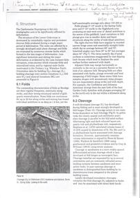
Sixteen page booklet Geological Survey Report, Mines Department Victoria. 'Geology of the Bendigo Area' by H.E. Wilkinson. Photo of Lansell's 222 Mine on the New Chum Line, Bendigo. Tallest poppet head on the field, approximately 38 m high, with a shaft depth of 635 m.bendigo, mining, geological survey report -
 Bendigo Historical Society Inc.
Document - CAROL HOLSWORTH COLLECTION: GEOLOGICAL REPORT BENDIGO GOLDFIELD BULLETIN 43
Four page document Geological Report Bendigo Goldfield, C.E. Willman and H.E. Wilkinson. Contents include: folds, cleavage, lineations, lineated quartz in laminated veins, faults, major and minor faults, joints, structural domains and relationship to mineralization.bendigo, mining, geological bulletin -
 Bendigo Historical Society Inc.
Document - CAROL HOLSWORTH COLLECTION: GEOLOGICAL REPORT BENDIGO
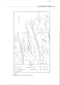
Four page document, not sequential. Front page: structural trends, major faults and folds in the Bendigo area are depicted in a diagram. Fault lines and folds include the Leichardt Fault, the Break O'Day Fault, Sebastian Fault, Whitelaw Fault, the Yankee Creek Fault and the Fosterville Fault. Aecond page shows the typical reef forms on the Bendigo goldfield (Willman 1988) in a diagram. The Sebastian goldfield is described, with its four lines of reef, the Eureka, Gaskill's, Frederick the Great and Gamboni. Third page describes the White Hills gravels. Fourth page is a table showing thel biostratigraphic zonation of the Ordovician bedrock based on key graptolite forms and assemblages.bendigo, mining, geological bulletin -
 Bendigo Historical Society Inc.
Document - CAROL HOLSWORTH COLLECTION: GEOLOGICAL REPORT BENDIGO GOLDFIELD
Four page document, an extract from the Geological Report on the Bendigo Goldfield. On front page, a line drawing of a puddling machine. Contents include: alluvial mining, reef mining, the boom years, deep sinking, decline of mining, modern exploration, physiography, the hills, the valleys and the soils. A table demonstrates the development of graptolite structures, including the Lancefieldian, Bendigonian, Chewtonian and Castlemainian graptolite species. Two diagrams demonstrate saddle and bedded reefs and fault reefs. Written on top of the document: C.E. William and H.E. Wilkinson, 1992. Geological Survey Report No. 93.bendigo, mining, geological bulletin 93 -
 Bendigo Historical Society Inc.
Document - CAROL HOLSWORTH COLLECTION: DEEP LEAD GOLD DEPOSITS OF VICTORIA
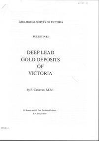
Bulletin 62 from the Geological Survey of Victoria, titled ' Derep Lead Gold Deposits of Victoria' by F. Canavan, M Sc. K. Bowen and H. Tan, Technical Editors, R.A. Bull, Editor. Bendigo and Sebastian District and the Huntly Telegraph Lead, are discussed in the paper.bendigo, mining, geological survey bulletin 62, bendigo, sebastian, geological survey. -
 Bendigo Historical Society Inc.
Book - BENDIGO MINING EXCHANGE - CONSERVATION MANAGEMENT PLAN - 2001
90 page spiral bound booklet Bendigo Mining Exchange, 18 Pall Mall Bendigo. Conservation Management Plan Prerpared for the City of Greater Bendigo by Allom Lovell and Associates, Conservation Architects, Melbourne. August 2001Allom Lovell & Associates -
 Bendigo Historical Society Inc.
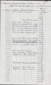
Document - ALBERT RICHARDSON COLLECTION: SHAFTS ALIENATED AND SITES RESERVED BY THE MINES DEPARTMENT
Handwritten one page table of information. On top of page ' Ref. derelict land in the City of Bendigo copied 17.4.62. Shafts alienated and sites reserved by the Mines Dept' List of mines, dates, depth of shaft, receiving body. For example: Londonderry, 1957, 2900 feet, Kindergarten. Reference: 'Derelict Land in the City of Bendigo' P.J. Rimmer and R.J. Johnston. Published jointly by the Dept of Geography, University of Sydney and The Geographical Society of NSW.Albert Richardsonbendigo, mining, derelict land reused -
 Bendigo Historical Society Inc.
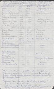
Document - ALBERT RICCHARDSON COLLECTION: DEEPEST SHAFT AND WINZES VICTORIA 1851 - 1911
Handwritten, 2 page, table of information showing mine name, alluvial or quartz and shaft depth. On top of page ' Deepest shafts and winzes Victoria 1851 - 1911. Reference: See Mines Report 1911, E.J. Dunn 10.11.08' Victoria Quartz mine Bendigo was the deepest. For example, entry reads: Victoria Quartz Mine, Bendigo, shaft 4270 plus 220 feet = total 4490 feet. Winze 385 feet from 4228 feet , No 37 Plat. Total 4613 feet from surface. Penthouse and cistern at 4228 feet. Shaft sunk to 4558 feet. Signed A.R.Albert Richardsonbendigo, mining, shaft depths -
 Bendigo Historical Society Inc.
Document - ALBERT RICHARDSON COLLECTION: A LOOK AT A MINE, LOOKING AROUND LONG GULLY 1900'S
Blue exercise book in which is a handwritten, in blue biro, a description of the basic principles under which most of the Bendigo mines operated, titled ' A look at a mine'. Information provided on four compartment shafts, poppet heads, boilers, engine rooms, skyshafts, landing brace, engine drivers. In the back section of the book is a recount of what Long Gully was like in the early 1900's, titled 'Around Long Gully in the early 1900's'Albert Richardsonbendigo, mining, albert richardson -
 Bendigo Historical Society Inc.
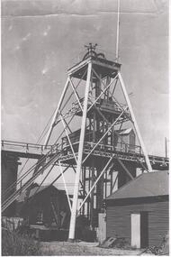
Photograph - NORTH DEBORAH GOLD MINE
Black and white photograph, copy, of the North Deborah Gold Mine poppet head, possibly taken in the 1940's. The trestle way and sky shaft used to convey ore to the landing brace are visible. Poppet head legs are metal and painted white. Corrugated iron sheds on right and in background. Air raid sirens on the top of the poppet head were used during World War 2 to warn the good citizens of Bendigo of any impending attack.bendigo, mining, north deborah gold mine -
 Bendigo Historical Society Inc.
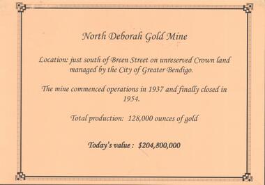
Photograph - NORTH DEBORAH GOLD MINE
Display interpretive sign for North Deborah Gold Mine. Mine located just south of Breen Street. Commenced operations in 1937 and closed in 1954. Total production 128,000 ounces of gold.Kay MacGregor, Bendigo Historical Societybendigo, mining, north deborah gold mine -
 Bendigo Historical Society Inc.
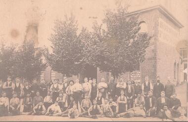
Photograph - HORWOODS FOUNDRY BENDIGO
Sepia tint photograph, copy. Image shows workers sitting outside the Horwood's Foundry, corner of Vine and Mackenzie Streets, C1880. Brick building behind workmen. 'Horwood & Sons' written on window. On side of building, RH wall is written 'Horwood's Foundry'. Horwood's manufactured mining machinery of various types. Their logo is on the stampers at the Deborah Gold Mine.bendigo, business, horwood's foundry -
 Bendigo Historical Society Inc.
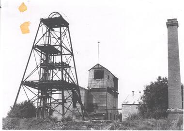
Photograph - DEBORAH GOLD MINE 1930'S
Black and white photograph, copy, of the Big Deborah Gold Mine, possibly taken in the 1930's. Deborah mine was near the junction of Abel and Adam Street, Golden Square. Image shows the mine site, a square brick chimney on the extreme RH side, engine room and stamper sheds in the middle and steel poppet head on LH side. Colour photo of Big Deborah, minus less the winding wheels at the top of the poppet legs.bendigo, mining, deborah gold mine -
 Bendigo Historical Society Inc.
Photograph - DEBORAH GOLD MINE, GOLDEN SQUARE
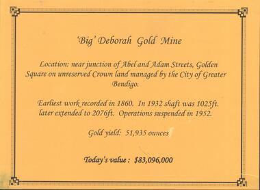
Information display card regarding the 'Big' Deborah Gold Mine, located near the junction of Abel and Adam Street, Golden Square. Earliest work recorded 1860. Shaft 2076 feet. Operations suspended in 1952. Gold yield 51,935 ounces. Battery shed still on site containing a 5 head stamper which was originally a 20 head stamper. The battery was manufactured by Horwood's Foundry, Bendigo. Photos of mine site taken in 2012: a.Engine room concrete footings, iron work visible. Pepper corn trees in background. Pampas grass in foreground. Steel mesh fence on RH side, enclosing the poppet head site. b. Concrete footings, peppercorn tree in background. c. Corrugated iron shed constructed over the stampers. Steel mesh front. d. Steel poppet head, no winding wheel at top. Pampas grass in foreground. e.. Stamper shed and steel poppet legs in background enclosing dilapidated wooden poppet head legs. f. Close up image of weights in stamper room g.Winding wheel on stampers h.Looking upwards to top of stampersbendigo, mining, deborah gold mine -
 Bendigo Historical Society Inc.
Document - CENTRAL NELL GWYNNE GOLD MINE
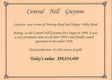
Interpretive sign and 4 photos Central Nell Gwynne Gold Mine, used in display. Central Nell Gwynne was located near the corner of Marong Road and Happy Valley Road. Opened in 1906, ceased operation in December 1949. Total production: 61,884 ounces of Gold. Today's Value: $99,014,400. Photos: a. Colour photo, concrete footings at mine site, April 2012. b. Colour photo, Central Nell Gwynne poppet head, April 2012.Poppet head painted white with red trim. Concrete footings in foreround. c. Central Nell Gwynne mine site 1930's. Poppet head and engine room sheds on LH side, trestle way to primary crusher and crushing battery. Tailing dam in immediate foreground. on RH side. Sand heaps in middle foreground. d. Central Nell Gwynne Mine 1930. Underground view, men holding carbide lamps working at 265 level in mine. Large quartz spur formation visible in foreground.bendigo, mining, central nell gwynne -
 Bendigo Historical Society Inc.
Document - NORTH DEBORAH , DEBORAH, CENTRAL NELL GWYNNE AND NAPOLEON GOLD MINES
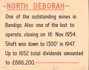
Five interpretive cards used for displays, yellow with black and orange text, describing the North Deborah, Deborah, Central Nell Gwynne and Napoleon Gold Mines. a. North Deborah: closed 16th November 1954. Shaft was 1300 feet deep. Total dividends 686,200 pounds. b. Deborah: underground operations suspended 1952, shaft 2076 feet. c. Central Nell Gwynne: operations ceased at end of 1949, shaft depth 1933 feet. d. Napoleon: first subsidiary company formed by BML to carry out comprehensive programme of development along Napoleon anticline. Shaft 1054 feet in 1937 when opertions ceased. e. Devonshire Sands, formed in 1933. Cyanide leaching plants installed on sand tailings heaps at Bendigo.Albert Richardsonbendigo, mining, north deborag mining company -
 Bendigo Historical Society Inc.
Document - CENTRAL DEBORAH GOLD MINE EMPLOYEES NAMES 1945 TO 1948
Small notebook, lined pages. Names, addresses and mining experience listed in pencil. Dates range from 1945 to 1948. Page near back of notebook details Spargo Creek Mine expenditure and shaft team.bendigo, mining, central deborah gold mine -
Bendigo Historical Society Inc.
Postcard - CENTRAL DEBORAH GOLD MINE BENDIGO POST CARDS
Fold out series of six colour postcards showing scenes from the Central Deborah Gold Mine. Images include: preparation for underground tour, winder driver and engine room, poppet head, first aid room, historic mining exhibits. Missing from Folder 131 2.2.2023. Richard LethleanAustralian Souvenirs and Marketing, 10-12 Roberna St. Moorabbin. 3189 -
 Bendigo Historical Society Inc.
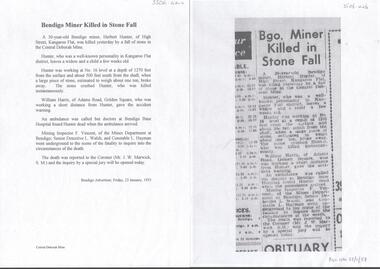
Newspaper - CENTRAL DEBORAH GOLD MINE MINING FATALITY
Newspaper article and typed copy of same, detailing the fatal accident that occurred at the mine on the 22nd January 1953, in which Herbert Hunter of Kangaroo Flat was killed. ' Hunter was working at No 16 level at a depth of 1270 feet from the surface and about 500 feet south from the shaft when a large piece of stone , estimated to wrigh about one ton, broke away. The stone crushed Hunter, who was killed instantaneously' Bendigo Advertiser article dated Friday 23rd January, 1953.bendigo, mining, central deborah gold mine -
 Bendigo Historical Society Inc.
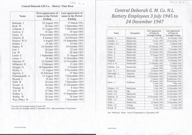
Document - CENTRAL DEBORAH GOLD MINE BATTERY TIME BOOK 1945 TO 1954
Two typed alphabetical listing of battery employees at the Central Deborah Gold Mine. One list covers period from 3rd July1945 to 24th December 1947. Other list covers period 26th June 1951 to 21st December 1954, when the mine and battery closed down.bendigo, mining, central deborah gold mine -
 Bendigo Historical Society Inc.
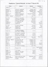
Document - CENTRAL DEBORAH GOLD MINE EMPLOYEES 1950 TO 1953
Typed document alphabetical listing of employees at the Central Deborah Gold Mine, dates from 1950 to 1953. Name of employee, address, start date and finish date included.bendigo, mining, central deborah gold mine -
Bendigo Historical Society Inc.
Document - MINING CATALOGUED ITEMS SUMMARY
List of mining items catalogued in Folders 121, 122, 124, 125, 129.bendigo, mining, catalogued items -
Bendigo Historical Society Inc.
Map - DEVONSHIRE GROUP OF MINES
Small map of Devonshire group of mines, Bendigo. Scale 8 chains to 1 Inch. Issued by M. P. Kelly sharebroker, Bendigo. Showing Hercules and Energetic, Pearl, New Victoria Catherine,, New St Mungo, xtended south devonshire, South Devonshire, United Devonshire,duchess of Edinburgh, Phoenix, South st Mungo, Lady Barkly, St. Mungo, Sadowa, Ellenborough, Williams' United, Catherine Reef United.bendigo, mining, devonshire mine -
 Bendigo Historical Society Inc.
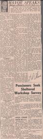
Newspaper - ALBERT RICHARDSON COLLECTION: THE MAYOR SPEAKS: MINE SITES
Newspaper article 'The Mayor Speaks' dated 12th August 1967, Bendigo Advertiser. Article by J.R. Flood. Mayor of Bendigo, detailing the location of mines including the Duchess of Edinburgh on the New Chum line, the mines on the Christmas line of reef, the Deborah reef mines, and the Sheepshead reef. Mine reclamation schemes are also addressed in the articlebendigo, mining, reef lines and mines -
 Bendigo Historical Society Inc.
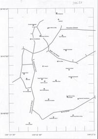
Document - CENTRAL DEBORAH GOLD MINE : GOLDEN SQUARE MINE SITES
Map showing mines in the Golden Square, Diamond Hill area. Roads include Diamond Hill Road, Burns Street, Woodward Road, Belle Vue Road, Houston Street. Latitude and Longitude on map.bendigo, mining, golden square mine sites -
Bendigo Historical Society Inc.
Document - BENDIGO & SANDHURST GOLD MINING COMPANIES FROM 1871, 1871-1950
Typed copy of the Bendigo & Sandhurst Gold Mining Companies From 1871. Vol 1 Victorian Government Gazettes. Eight pages. Includes Mine name, Reef/Gully, Place/Suburb, Mine Manager -
 Bendigo Historical Society Inc.
Document - ALBERT RICHARDSON COLLECTION: THE VICTORIA HILL HISTORICAL ASSOCIATIONS
Five page handwritten document (copy) on the history of Victoria Hill, Ironbark, Bendigo. 'Gold first found in 1853 by two colored men, one named Weymouth or 'Dido' and sold to Theodore Ballerstedt Senior, who in December 1853, was known as the 'Father of the Hill'.'bendigo, mining, victoria hill -
 Bendigo Historical Society Inc.
Document - ALBERT RICHARDSON COLLECTION: CARLISLE UNITED MINE GARDEN GULLY LINE
Eight page handwritten document with details of the Carlisle United Gold Mine at Long Gully. The lease was 76 acres, 660 yards on line of reef. The Kent shaft was the next mine north Havilah Road, Boldt Street's corner. 'The Carlisle United was formed by the amalgamation of ttte companies, the Old Carlisle, the North Garden and the Passby. These mines were situated on the west side of Bennett Street in about a length of a few hundred feet, with the Passby on the Casley Street corner. And the old Carlisle and North Garden only recently being unearthed beneath the Unity, 'Carlisle' sand heap.' Details about the mining plant, the main shaft, the winding engine air compressor, stone crusher, and engine house are given. The Kent shaft and steel poppet legs are described. Four early claims on the Carlisle United ground are listed: Morgan, Kirshner and Co., Boyd and Co. Claim, Shanks and Co's claim and Day and Co's claim.bendigo, mining, carlisle united -
 Bendigo Historical Society Inc.
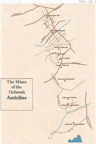
Document - THE MINES OF THE DEBORAH ANTICLINE
Plan of the mines along the Deborah Anticline: Deborah Consolidated, Deborah Associated, Deborah United, Deborah Extended, South Deborah, No. 2 shaft, Deborah North Deborah, Central Deborah, Monument Hill are all sited on the plan.Philip Wilkin, volunteer, BHSbendigo, mining, deborah line of reef -
 Bendigo Historical Society Inc.
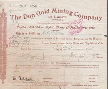
Document - WARNE COLLECTION: THE DON GOLD MINING COMPANY SHARE SCRIPT
Share certificate for 50 shares in the Don Gold Mining Company, no liability, Bendigo issued to M. H. Ashton of Melbourne. Date on the certificate 06 April, 1905business, mining, the don gold mining company