Showing 847 items
matching land subdivision
-
 Bendigo Historical Society Inc.
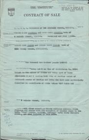
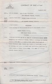
Document - H. A. & S. R. WILKINSON COLLECTION: CONTRACT OF SALE
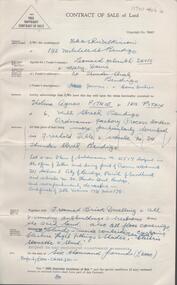
Contract of sale dated 27th March, 1958 between Mr. V. V. & Mrs R. M. Wodetzki (vendor) and Mr. L. J. & Mrs. T. M. Pascoe (purchaser). Solicitor for vendor: Watson, James & Rogers, Bull Street, Bendigo. Solicitor for purchaser: Watson, James & Rogers, Bull Street, Bendigo. Property 4 Malcom Street, Bendigo being lot 5 on plan of subdivision No. 22158(?) lodged in the office of titles and being part of Crown allotment8 and 9 section 165C land described in certificate of title volume 7597 folio 005(?), together with all floor coverings, blinds, curtains, electric light fittings and shades with the exception of crystal hade in the hall. "Shor" washing machine, "Masters" early electric stove. Price: 6,200 pounds. Attached Statement pursuant to section 34 of the estate agents act 1956 and 4 hand written notes.organization, business, h.a. & s.r wilkinson real estate -
 Bendigo Historical Society Inc.
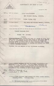
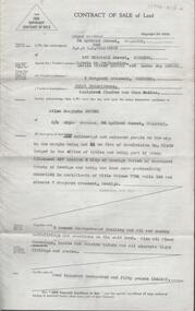
Document - H. A. & S. R. WILKINSON COLLECTION: CONTRACT OF SALE
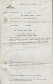
Contract of sale of land dated 11th January, 1956 between Mr. W. S. Bond (vendor) and Mr. R. B. Scott (purchaser). Property: surface and down to a depth of 50 feet below the surface of that piece of land being lot 71 on plan of subdivision lodged in the office of titles No. 16993 being part of Crown allotment 441B section H Parish of Sandhurst city of Bendigo and situate Corner Neale & Burrell Streets, Bendigo, together with brick dwelling, all sundry outbuildings, all floor coverings, all blinds, all electric light fittings and shades, Hoover washing machine, all curtains except those in the 2 front rooms and electric stovette. Price: 3,950 pounds.organization, business, h.a. & s.r wilkinson real estate -
 Bendigo Historical Society Inc.
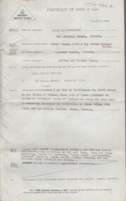
Document - H. A. & S. R. WILKINSON COLLECTION: CONTRACT OF SALE
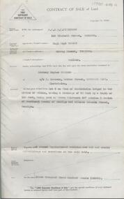
Contract of sale of land dated 25th August, 1956 between Mr. A. T. & Mrs. I. M. H. James (vendor) and Mr. J. H. Strange (purchaser). Property: lot 1 on plan of subdivision no. 19491 lodged in the office of titles being part of Crown allotment 24 Parish of Sandhurst County of Bendigo, land described in certificate of title volume 7646 folio 003 and situate Beischer Street, Bendigo, together with 5 roomed weatherboard dwelling, all sundry outbuildings, all floor coverings, blinds, curtains, Metro fridge, "Mettres" electric range, Hoover washing machine and all electric light fittings and shades. Price: 2,780 pounds. Attached 5 hand written notes .organization, business, h.a. & s.r wilkinson real estate -
 Bendigo Historical Society Inc.
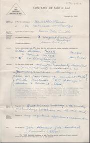
Document - H. A. & S. R. WILKINSON COLLECTION: CONTRACT OF SALE
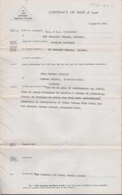
Contract of sale of land dated 24th February, 1956 between Mrs. D. I. Smith (vendor) and Mr. A. W. & Mrs. N. Pulfer (purchaser). Solicitor for vendor: E. C. Cohen. Solicitor for purchaser: Hyett, Willis & Hyett. Property: land being lot 13on plan of subdivision No. 21180 lodged in the office of titles, being part of Crown allotment 457 section H Parish of Sandhurst described in certificate of title volume7793 folio 150 and situate No. 3 Margaret Crescent, Bendigo, together with brick veneer dwelling and all sundry. Price: 5,500 pounds.organization, business, h.a. & s.r wilkinson real estate -
 Bendigo Historical Society Inc.
Document - H. A. & S. R. WILKINSON COLLECTION: CONTRACT OF SALE
Contract of sale of land dated 5th November 1955 between Mr. L. H. & Mrs. M Davis (vendor) and Misses T. A. & I. Pithie (purchaser). Solicitor for vendor: H. E. Every. Solicitor for purchaser: Neal Woodward. Property: Lot 4 on plan of subdivision No.21517 lodged in the office of titles being part of Crown allotment 351 section E, land described in certificate of title volume 7731 folio 178, together with 5 room brick dwelling also all floor coverings, blinds, curtains, electric light fittings and shades, electric stovette and stand. Price: 6,000 pounds.organization, business, h.a. & s.r wilkinson real estate -
 Bendigo Historical Society Inc.
Document - H. A. & S. R. WILKINSON COLLECTION: CONTRACT OF SALE
Contract of sale of land dated 30th August 1955 between Mr. E. M. Hopper (vendor) and Mr. J. H. & Mrs. E. E. Parker (purchaser). Property: land being part of Crown allotment3 section 5A having a frontage of 38 feet 8 inches as shown on plan of subdivision consented by the city of Bendigo on Wednesday 6th August, 1955 and situate block 5, No. 110 Penton Street, Golden Square, together with 5 roomed weatherboard dwelling as inspected to be completed similar to Mrs. James property 650 High Street, Golden Square. Price: 3,200 pounds. .organization, business, h.a. & s.r wilkinson real estate -
 Bendigo Historical Society Inc.
Document - H. A. & S. R. WILKINSON COLLECTION: CONTRACT OF SALE
Contract of sale of land dated 17th August, 1955 between Mr. H. B. Morgan (vendor) and Mr. L. H. Parsons (purchaser). Property: land being lot 3 on plan of subdivision lodged in the office of titles, having a frontage of 50 feet by a depth of 150 feet, being part of Crown allotment 547section H and situate in Osborne Street, Bendigo, together with 5 roomed weatherboard dwelling and all sundry. Price: 3,300 pounds.organization, business, h.a. & s.r wilkinson real estate -
 Bendigo Historical Society Inc.
Document - H. A. & S. R. WILKINSON COLLECTION: CONTRACT OF SALE
Contract of sale of land dated 12th July 1955 between Mr. C. Naismith (vendor) and Mr. J. M. Parsons (purchaser). Property: land being lot 20 on plan of subdivision No. 22101 part of Crown allotment 60 section D Parish of Mandurang, County of Bendigo and being land described in certificate of title volume 7925 folio 69 and situate Archer Street, Kangaroo Flat. Price: 140 pounds.organization, business, h.a. & s.r wilkinson real estate -
 Bendigo Historical Society Inc.
Document - H. A. & S. R. WILKINSON COLLECTION: CONTRACT OF SALE
Contract of sale of land dated 9th February 1955 between Mr. R. J. Sanderson (vendor) and Mr. L. A. Pitson (purchaser). Property: Lot 55 on plan of subdivision No. 16998 lodged in the office of titles, having a frontage to Burrell Street of 50 feet by a depth of 140 feet, being part of Crown allotment 432 section H Parish of Sandhurst County of Bendigo, land described in certificate of title volume 7314 folio 636 and situate Burrell Street, Bendigo, together with the fencing thereon. Price: 425 pounds.organization, business, h.a. & s.r wilkinson real estate -
 Bendigo Historical Society Inc.
Document - H. A. & S. R. WILKINSON COLLECTION: CONTRACT OF SALE
Contract of sale of land dated 12th January, 1955n Mr. L. W. & Mrs. L. M. Dennis (vendor) and Mrs. A. M. Praetz (purchaser). Property: land delineated and coloured purple on the map in the margin being lot 11 on plan of subdivision 21180 lodged in the office of titles being part of Crown allotment 457 section H Parish of Sandhurst, City of Bendigo, land described in certificate of title volume 7793 folio 149 and situate 7 Margaret Crescent, Bendigo, together with 5 rooms weatherboard dwelling and all sundry buildings on said land, also all floor coverings, blinds and electric light fittings and shades. Price: 4,150 pounds.organization, business, h.a. & s.r wilkinson real estate -
 Bendigo Historical Society Inc.
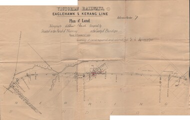
Document - BUSH COLLECTION: PLANS PERTAINING TO LAND OF S. A. BUSH
A: Plan of subdivision of Allots 6, 7, 8, 15 & 16, Sec. 62C, City of Bendigo (The Property of Albert Bush, Esq.) - Plan is torn in half forming two pieces (see 'Condition'. Pinned note attached to one piece. B: Victoria Railways, Eaglehawk & Kerang Line (Albert Bush land, Parish of Nerring, County of Bendigo.person, individual, bush collection - personal -
 Bendigo Historical Society Inc.
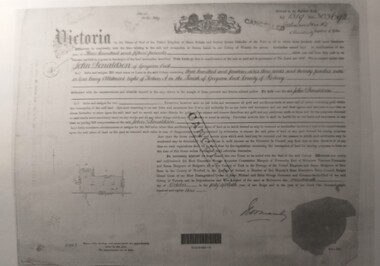
Document - CERTIFICATE OF TITLE
... Certificate of titles and its subdivision plans for land... MELBOURNE Certificate of titles and its subdivision plans for land ...Certificate of titles and its subdivision plans for land bought by George Lansell in Toorak. Dated 27th August 1874.melbourne -
 Bendigo Historical Society Inc.
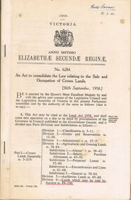
Book - 1958 VICTORIA ANNO TERTIO ELIZABETHÆ SECUNDÆ REGINÆ NO. 6284, 23/2/60
A small book owned by Accountant & Auditor Harold Curnow dated 23/2/60 detailing "An Act to consolidate the Law relating to the Sale and Occupation of Crown Lands." on page 61 it also has a 2/10/61 newspaper article and a June 27, 1962 page from the Victoria Gazette both of them detailing the Laws. The first page is written as following "Harold Curnow 1958. VICTORIA ANNO SEPTIMO ELIZABETHÆ SECUNDÆ REGINÆ No. 6284. An Act to consolidate the Law relating to the Sale and Occupation of Crown Lands, [30th September, 1958.] Be it enacted by the Queen's Most Execellent Majesty by and with the advice and consent of the legislative Assembly of Victoria in this present Parliament assmled and by the authority of the same as follows (that is to say) 1. This act may be cited as the Land Act 1958. and shall come into operation on a day to be fixed by proclamation of the Governor in council published in the Goverment Gazette, and is divided into Parts Divisions and Subdivisions as Follows:-"victoria -
 Tatura Irrigation & Wartime Camps Museum
Document, Certificate of Payment - John Donaldson
Certificate of payment to John Donaldson, vol 1519 folio 303692, memorials of instruments and titles office record of subdivision.3 pages of copies of original paperwork relating to J Donaldson ownership of land.john donaldson, vol 1519 folio 303692, memorials of instruments, titles office record of subdivision, certificate of payment -
 Tatura Irrigation & Wartime Camps Museum
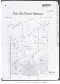
Certificate of Title, Subdivisions, 1879 and 1930
Title Deeds for property in Tatura2 certificates of title showing subdivisions made over several years. Vol. 5655:Folio 1130935 dated 16/5/1930 and Vol.1182: Folio 236330 dated 23/12/1869. Lease between Thomas Hogan and W F Bazeley dated 7th July 1911 for land in Hogan Street known as Slaughter Yard Paddock .Also lease dated 1911. In buff coloured legal envelope with number "2678" and "Hogan - Thomas" written in red on outside.tatura, relationship folders, certificate of title, lease, thomas hogan, john hogan, john james hanlon, edward glover, arthur burke, james brady, andrew collie, jean hunter, sydney embling, john maher, arthur goyen, patrick o'toole, philipe dove, george wildon, edwin harden, cuthbert corke, lee chung, hugh barnes, george manning, francis williams, john fawkner, michael walshe, alexander ferguson, rose gullett, john gibb, william taylor, richard casey, anthony grover, arthur grover, charles brady, elizabeth davey, frank williams, honora culkin, alexander park, stephen reville, richard carr, charles grover, henry mccarthy, james bruce, edward hanley, chew yen, ah poy, loo way, ah dick, charles mitchell, lionel martin, douglas forsyth, catherine wilson, mabel heath, patrick mcnamara, micheal cussen, james wilson, bazeley, documents, legal -
Tatura Irrigation & Wartime Camps Museum
Poster, Tatura Subdivision, 1928
Hogans Estate was privately owned land on Tatura's north side as opposed tot he government sub division when Tatura was founded.Large Tatura subdivision poster of 1928 advertising large area north of Hogan Street, named Hogan Estate. Clear plan of subdivisions. Bold print in red and blue.Great subdivision sale. Hogans Estate Tatura. Saturday 18 August 1928. J. McNamara & Co.tatura subdivision, hogans estate -
 Whitehorse Historical Society Inc.
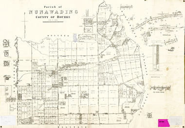
Legal record - Map, Parish of Nunawading, c1930
Office of Lands and survey map, 1864 with many further subdivisions of 1870 onwards added.Office of Lands and survey map, 1864 with many further subdivisions of 1870 onwards added. Boundaries of City of Box Hill included. Note added re Slater's land in Blackburn North. Office of Lands and survey map, 1864 with many further subdivisions of 1870 onwards added. maps, shire of blackburn and mitcham, city of box hill, slater family -
Whitehorse Historical Society Inc.
Legal record - Land Title, Creation of easement, 1929
Ethel Mary Halley of Wellington Road Marylands S.A., registered proprietor of Lot 4 on Plan of Subdivision 4104 [Tyrrell Avenue Blackburn] to use for the purpose of drainage. Title Vol. 4824 Fol. 964713Ethel Mary Halley of Wellington Road Marylands S.A., registered proprietor of Lot 4 on Plan of Subdivision 4104 [Tyrrell Avenue Blackburn] to use for the purpose of drainage. Title Vol. 4824 Fol. 964713Ethel Mary Halley of Wellington Road Marylands S.A., registered proprietor of Lot 4 on Plan of Subdivision 4104 [Tyrrell Avenue Blackburn] to use for the purpose of drainage. Title Vol. 4824 Fol. 964713tyrrell avenue, blackburn -
Whitehorse Historical Society Inc.
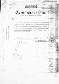
Legal record - Land Title, Certificate of Title, 1919
Lots 21 and 22 on Plan of Subdivision no. 6149 Crown Portion 89, Parish of Nunawading vol. 4192 fol. 838287, owned by State Savings Bank of VictoriaLots 21 and 22 on Plan of Subdivision no. 6149 Crown Portion 89, Parish of Nunawading vol. 4192 fol. 838287, owned by State Savings Bank of VictoriaLots 21 and 22 on Plan of Subdivision no. 6149 Crown Portion 89, Parish of Nunawading vol. 4192 fol. 838287, owned by State Savings Bank of Victoriablackburn road blackburn, walsham road blackburn, state savings bank of victoria -
 Whitehorse Historical Society Inc.
Document, Deep Creek Road, 13/04/1929
Photocopy of Certificate of Title Vol 5525 Fol. 1104883, land fronting on Deep Creek Road, Mitcham being lot 136 on Plan of Subdivision No 8022, part of Crown Portion 128A, Parish of Nunawading, County of Bourke, in the name of Francisco Schwerkolt, 13 April 1929, on her death in 1946, probate granted to Charles Victor Schwerkolt.Passed to Frances Dora Hogan in 1947, Alice Maud Everitt in 1950, Charles Edward Everitt and Muriel Eileen Priscilla Edwards in 1953, Stanley Ernest Edward Dawson and Iris Rae Dawson in 1973, Glenn Joseph Benham and Judith Rae Benham in 1975 and Ernest Victor Copling and Barbara Ruth Copling in 1980.deep creek road, mitcham, schwerkolt, francesca, charles clarence victor, schwerkolt cottage, hogan, frances dora, everitt, alice maud, charles edward, edwards, muriel eileen priscilla, dawson, stanley ernest edward, iris rae, benham, glenn joseph, judith rae, copling, ernest victor, barbara ruth -
 Whitehorse Historical Society Inc.
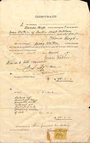
Document, Mitcham, 1/03/1915
Contract of sale of part Crown Portion 119,05 Mitcham, Parish of Nunawading, County of Bourke being Lot 6 on plan of subdivision No. 5339, by Thomas Keogh to Jessie Wathenland sales, wathen, jessie, keogh, thomas, mitcham -
 Whitehorse Historical Society Inc.
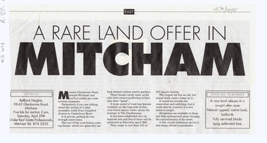
Article, A Rare land offer in Mitcham, 25/04/1995 12:00:00 AM
Rare land offerNewspaper article about a new subdivision in Glenburnie Road, MitchamRare land offerauctions, glenburnie road, mitcham, langford avenue, canterbury road -
Whitehorse Historical Society Inc.
Document, Certificate of Title, 1917 - 1933
Certificate of Title, Harrison Rotherham of 'Thulecroft', Albion Street, Surrey Hills, Merchant.Certificate of Title, Harrison Rotherham of 'Thulecroft', Albion Street, Surrey Hills, Merchant. Lots 61 & 62, subdivision 602, Part of Crown Allotment 127, Parish of Nunawading, County of Bourke with a right of carriage way over Harrison and Burnett streets, 1917. Vol 4046, Fol 809049. Also correspondence re rates, enforcement of charge, 1933.Certificate of Title, Harrison Rotherham of 'Thulecroft', Albion Street, Surrey Hills, Merchant.land titles, shire of nunawading, shire of blackburn and mitcham, rotherham, harrison, harrison street, mitcham, burnett street, mitcham -
Whitehorse Historical Society Inc.
Document, Certificate of Title, 1922, 1933
Certificate of Title, Margaret Kennedy.Certificate of Title, Margaret Kennedy. Lots 100, 101 & 102, subdivision 1968, part of crown allotment 1270, Parish of Nunawading, County of Bourke 1922 vol 4583, fol 916577 also rates enforcement of charge, 1933.Certificate of Title, Margaret Kennedy.land titles, shire of blackburn and mitcham, kennedy, margaret, mcdowall street, mitcham -
Whitehorse Historical Society Inc.
Document, Certificate of Title, 1921, 1933
Certificate of Title, Charles Norris and William Richard Norris.Certificate of Title, Charles Norris and William Richard Norris. Lot 6 Subdivision 4894, part of crown portions 89 & 90, Parish of Nunawading, County of Bourke 1922. Vol 4474, fol 894734 also correspondence re rates, enforcement of charge 1933.Certificate of Title, Charles Norris and William Richard Norris.land titles, shire of blackburn and mitcham, norris, charles, norris, william richard, blackburn road, blackburn -
Whitehorse Historical Society Inc.
Document, Certificate of Title, 1923 - 1934
Certificate of Title, William Arthur Hirst.Certificate of Title, William Arthur Hirst. Lot 20 Subdivision 6626, part of crown allotment 127A at Mitcham, Parish of Nunawading, Count of Bourke. Vol 4671, fol 934063. Also correspondence re rates enforcement charge, 1933-34.Certificate of Title, William Arthur Hirst.land titles, shire of blackburn and mitcham, hirst, william arthur, shire of nunawading, thomas street, mitcham -
Whitehorse Historical Society Inc.
Document, Certificate of Title, 1915, 1933
Certificate of Title, Frederick William GibbonsCertificate of Title, Frederick William Gibbons, Lot 88, Subdivision 1968, part of crown allotment 1270, Parish of Nunawading, County of Bourke 1915. Vol 3882, fol 776385 also correspondence re rates, enforcement of charge, 1933.Certificate of Title, Frederick William Gibbonsland titles, shire of blackburn and mitcham, gibbons, frederick william, shire of nunawading, burnett street, mitcham, gort road, mitcham -
Whitehorse Historical Society Inc.
Document, Certificate of Title, 1924, 1933
Certificate of Title: Edmund Francis ShapleyCertificate of Title: Edmund Francis Shapley, Lot 277 subdivision 3051 Parish of Nunawading Vol.4945 Fol. 988875 1924., Certificate of Title: Myra Constance Agnes Robinson Lot 278 Subdivision 3051. As above. Vol 4945 Fol,988876 1924, Rates - enforcement of charge 1933 & rates enforcement charge 1933.Certificate of Title: Edmund Francis Shapleyland titles, shire of nunawading, shire of blackburn, mitcham, shapley, edmund francis, robinson, myra constance agnes, alfred street blackburn -
Whitehorse Historical Society Inc.
Document, Certificate of Title, 1928, 1933-1934
Certificate of Title, Nanny Schifferdecker.Certificate of Title, Nanny Schifferdecker. Lots 44, 45,56 & 57 subdivision 3360 Crown portion 97 Parish of Nunawading, County of Bourke 1928. Vol 5406 fol 10881070 1928, Agnew and Craig Streets. Also correspondence re rates enforcement charge 1933.Certificate of Title, Nanny Schifferdecker. land titles, shire of blackburn and mitcham, schifferdecker, hanny, craig street, blackburn south, agnew street, blackburn south -
Whitehorse Historical Society Inc.
Letter - Correspondence, Abattoir Property, 1937
Letter between City of Box Hill and Shire of Blackburn and Mitcham re sale of Lot 2, Abattoir Estate. A plan of subdivision and list of allotments for auction by City of box Hill on 27 Oct 1937.Letter between City of Box Hill and Shire of Blackburn and Mitcham re sale of Lot 2, Abattoir Estate. A plan of subdivision and list of allotments for auction by City of box Hill on 27 Oct 1937.Letter between City of Box Hill and Shire of Blackburn and Mitcham re sale of Lot 2, Abattoir Estate. A plan of subdivision and list of allotments for auction by City of box Hill on 27 Oct 1937.land sales, city of box hill, shire of blackburn and mitcham, abattoirs paddock, aspinalls estate, woodhouse grove, box hill north, koonung creek, bishop, herbert thomas