Showing 10948 items matching "lander"
-
 Kew Historical Society Inc
Photograph - Flooding of the Yarra Valley at Kew East, 1974
Flooding of the Yarra Valley, including that section of the Yarra bordering Kew and Kew East in the north and west of the municipality, was a regular occurrence. Extreme flood events of the Yarra River are recorded to have occurred in 1891, 1901, 1916, 1923 and 1934. The Municipality of Kew's response to these floods was to enact planning decisions restricting residential development in flood prone areas following the floods of 1916, 1921 and 1934. While floods continued after the development of the Upper Yarra Reservoir (construction 1948-57), the regularity and extent of these inundations diminished. During the nineteenth century, the land abutting the south side of the Yarra in Kew was devoted to dairy farming. In the twentieth century, before and after the construction of the Eastern Freeway, much of this low-lying area was used as golf courses and public parks.Late example of the capacity of the Yarra Valley at Kew to flood, even though drainage works and the Upper Yarra Reservoir had reduced their regularity.Original black and white print photograph of the low-lying land at East Kew under floodwater on 16 May 1974. The vantage point of the photographer is Lister Street. Flooding was caused by overflowing water in Glass' Creek and the River Yarra. Annotation verso: "Lister St looking same as No.3 / 16 May 1974 11.30"floods, yarra river, glass' creek, lister street -
![Map, Plan of Town Allotments Bacchus Marsh [1873]](/media/collectors/5e461d8021ea67224c82f2a1/items/677a8ee7ab7bb47995c5573f/item-media/677a8fdeab7bb47995c55b56/item-fit-380x285.jpg) Bacchus Marsh & District Historical Society
Bacchus Marsh & District Historical SocietyMap, Plan of Town Allotments Bacchus Marsh [1873]
James Young was a prominent businessman, land owner and public figure in the early colonial period of Bacchus Marsh. After his death in 1871 land remaining from his estate in Bacchus Marsh was sold at auction in 1873. The sale of his estate included the substantial stone residence in Bennett Street which later became known as 'Stone Villa'. The sale of his land in 1873 was conducted by local auctioneer James Crook. 29 allotments were advertised for sale, although the plan for the sale indicated 30 allotments. The sale notice in the Bacchus Marsh Express of 11 October 1873 noted that the allotments were " in the very centre and heart of the most populous and business portion of the township, at the same time being the only remaining portion of the business block available for purchase by public sale, which fact intending purchasers should not lose sight of, as the opportunity cannot occur again". The designation of a new street, 'Bennett Street', shown on the plan, is also indicated in the advertising, "In reference to the main street frontages, opposite the Border Flour Mills. The Auctioneer would also direct attention to the plan, showing the formation of a new thorough fare (Bennett street) leading from Young street into Gell street, thus opening up the township on the high, more healthy, and commanding position so much to be desired for private dwellings".An important cartographic document which indicates an early major subdivision of land in the inner urban area of the Bacchus Marsh township. This subdivision lead to the continuing residential and commercial development of the township of Bacchus Marsh in the later part of the 19th century. The location of two well known demolished public structures, the Free Gardeners Hall in Gell Street, and the Old Mechanics Institute Hall (aka the Buffs Hall), on the corner of Young and Bennett Streets, are also shown on this map.A single page paper map showing 30 blocks of land for sale around 1873 in the vicinity of Bennett Street and Lerderderg Street. Described in contemorary sources as a 'lithographed copy'. No scale is indicated. The map is pasted into a bound volume containing 76 maps or plans in total. High resolution digital image stored on BMDHS computer network. land sales bacchus marsh, bacchus marsh victoria maps, james young 1816-1871, bacchus marsh roads and streets, bennett street bacchus marsh -
 Ringwood and District Historical Society
Document - Land Title, John Quinlan et al, Land title (Ringwood) and correspondence between George Pratt of Nunawading and the Commissioner of Crown Lands 1869-1877, 1869
Land title and correspondence between George Pratt and the Commissioner of Crown Lands and Survey dated 19th(?) August 1869. Numbered 16678 (1M) plus 20 pages marked 42M-61M +Additional Keywords: Commissioner of Land and Survey / Longmare, Mr. / Quinlan, John -
Port Melbourne Historical & Preservation Society
Document - Contract of Sale for 84 Dow Street, Port Melbourne, Law Institute of Victoria, 8 July 1982
The 1928 Contract of Sale is for the land which became 84 Dow Street, Port Melbourne. The land was sold by Catherine Fleming BARLOW of East Kew to Sydney William NEWMAN for the sum of 875 pounds. The deposit was 100 pounds with a quarterly re-payment of 10 pounds.Purchase completeddow street, built environment - domestic -
 Ringwood and District Historical Society
Document - Department of Lands and Survey, Wire Netting Branch, Melbourne, Victoria, Application for Vermin-Proof Fence Certificate - L.J. Mills vs John Collins, Grandview Grove, Ringwood, Victoria - 1939
Photocopied file of corresponence and documentation relating to a claim by L.J. Mills, Nurseryman, that adjoining property owner, J. Collins, Farmer, assists with replacement of a vermin proof wire netting dividing fence destroyed by 1939 bushfire. File includes 1939 and 1940 detailed property inspection reports by Vermin and Noxious Weeds Branch, Lands Department, Lilydale, describing land use in the area and signs of vermin activity. Application approved 18th April, 1940. Appeal lodged by Mr Collins disallowed in May, 1940. File closed June, 1940 with Departmental suggesion that Mr Mills consider further legal action through a Solicitor as fence had still not been wire-netted. TRANSCRIPTS: Vermin & Noxious Weeds Inspection Reports "19/9/1939 (To) Superintendent (Department of Lands and Survey, Melbourne) Re L.J. Mills application for Vermin Proof Fence. I called on Mr Mills yesterday 18th instant in connection with this matter. Mr Mills has a flower farm and claims that rabbits and hares are damaging his flowers. He showed me a bed of carnations which he stated were being damaged by rabbits. There was evidence of some leaves being nipped off, but I am unable to say whether this is due to rabbits or grubs. Very little if any real damage is being done. The property is netted on the east and south boundary and on half the north and west boundary. The surrounding country is undlating and fairly steep in places. The land to the east across Grandview Avenue (sic) is all planted out in old established orchards and well cultivated. Cleared grass land adjoins the south boundary and bush land adjoins the north and west boundaries. I walked over a large area surrounding Mr Mills land and never saw any rabbits or hares or any indications of rabbits. This locality is not rabbit infested and very little wire netting is being used. I do not consider that a vermin proof fence is necessary between these allotments. - Jas H Allison (Inspector, Vermin and Noxious Weeds Branch, Lands Department, Lilydale)." Follow up report following renewal of application for Certificate by Mr Mills, citing rabbits causing considerable damage to his flowers. He laid poison and obtained 9 carcases and stated that there is evidence of rabbit infestation from the adjoing land. "19/3/1940 (To) Mr Hannah (Superintendant, Department of Lands and Survey, Melbourne) Re L.J. Mills, Grandview Grove Ringwood, Lot 4 Grandview Estate Pt CG20 Ph of Warrandyte. I interviewed Mr Mills at his home on 15th inst. He showed me carcases of rabbits which he stated had been poisoned on his land. In places young plants had been nipped off apparently by rabbits. I made an inspection of adjoining properties and found one live burrow close to Mr Mills northern boundary. There were scratches and other evidence of rabbits on land north and west of Mr Mills property. In view of the present evidence of rabbits I consider that a vermin proof fence is now necessary to protect the flowers grown by Mr Mills. His land is netted on whole of east and south boundary and half way on west and north boundary. The adjoining land on west and north boundaries is owned by Mrs Linda Collins and John Collins resp of Brysons Road East Ringwood. - Jas H Allison (Inspector, Vermin and Noxious Weeds Branch, Lands Department, Lilydale)." -
 Warrnambool and District Historical Society Inc.
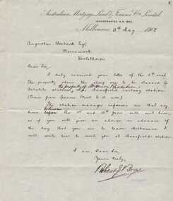
Letter, Australian Mortgage Land and Finance to Augustus Bostock, 1900
Augustus Bostock was the 9th child of Robert & Rachael Bostock of Vaucluse Epping Forest, Van Diemen’s Land. He was only 4 years old when his mother died. He was inspired by his father to seek his fortune in the Western District of Victoria. He arrived around 1850. He married Margaret Aitkin in July 1865. Augustus owned several properties in the district and leased others. He sat on the court of Warrnambool, Mortlake or Hexham as required. He resided at Marramook in Hawkesdale and later moved to Vaucluse in Hopetoun Road Warrnambool, where he died in 1920 at the age of 87. He was involved in many aspects of life in the Western District, racing, cricket, and social activities to name a few. This letter is written in reply to an earlier one by Augustus making himself available to do wool and sheep classing. This states of the availability of work at Delatite Station the property of Mr. Henry Ricketson one of many properties he owned.This letter follows from previous ones showing Augustus Bostock in his quest for work. Cream lined paper with Australian Mortgage Land and Finance letterhead printed at top of letter. The letter is handwritten in black ink with adjustments written in same hand as the signer of the letter. Blue secretary stamp underneath signature.Addressed to Augustus Bostock Esq Marramook Woolsthorpe. Signed by Robert **Boyne. Dated May 15th 1900. Watermarked, Original Turkey Mill Trent. augustus bostock, warrnambool -
 Ringwood and District Historical Society
Newspaper, Scrapbook Clipping, Library Collection, Ringwood, Victoria, `
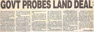
``Newspaper clipping from "The Post" 26-7-95, P 1. GOVT PROBES LAND DEAL The proposed multi-million dollar sale of the Ringwood Bowling Club site to retail giant Coles Myer, is currently being investigated by the State Government. Local Government minister, Roger Hallam, confirmed the Office of Local Government investigation this week.` -
 Bendigo Military Museum
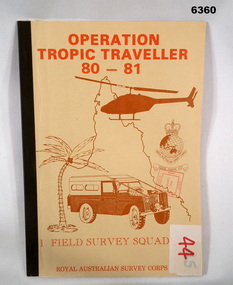
Administrative record - Operation Tropic Traveller 80 - 81 1 Field Survey Squadron, 1981
Project report, Operation Tropic Traveller 1980/81 was mounted to field complete the North Queensland Tac map area during the periods 25 Feb to 11 Nov 1980 and 3 Mar to 13 Oct 1981 Buff colored, A4 Folder, Mosaic in brown of Nth Qld, Helicopter, Corps badges, Land rover.1 field survey squadron, 1 fd svy sqn, royal australian survey corps -
 Phillip Island and District Historical Society Inc.
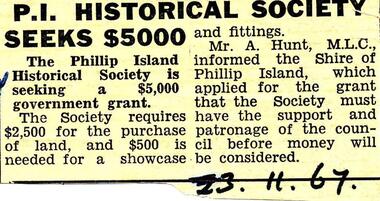
Newspaper clippings, 23/11/1967
Collection of newspaper clippers in scrap book dated 1960 - 1973Newspaper article concerning a financial grant being sought by the Phillip Island Historical Society for land and a showcase."P.I. Historical Society seeks $5,000"local history, newspapers, phillip island historical society seeking grant of $5000, jean jamieson -
Glenelg Shire Council Cultural Collection
Photograph - Photograph - Henty Beach, Aug-89
Port of Portland Authority ArchivesBack: 'Henty Beach area (Yacht club end) August 89 -
Glenelg Shire Council Cultural Collection
Photograph, Portland Wool Brokers Limited, Wool Store, n.d
Port of Portland AuthorityFront: (no inscriptions) Back: 177 (top left, pencil)port of portland -
Eltham District Historical Society Inc
Photograph, Top of the Devils Bank - Eltham, 1906c
Photograph from land sales brochure c1906 showing scene from top of the Devils Bank Elthamdevils bank, eltham -
 Federation University Historical Collection
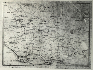
Photograph - Black and White, Map of Western Victoria
WGS 84 37" 47' S 142" 08' EPhotograph of a map showing the Grampians, Glenelg, Portland, Belfast (Port Fairy), Warrnambool, roads and land-holders.western victoria, victoria, belfast, port fairy, warrnambool, manifold -
Glenelg Shire Council Cultural Collection
Photograph - Photograph -Reclamation and Canal work, 1959
Port of Portland Authority ArchivesBack: November 1959 - Top right, black biro. Reclamation and canal work at southern end of botanic gardens - bottom left, pencil.port of portland archives, land reclamation, canal -
Glenelg Shire Council Cultural Collection
Photograph - Photograph - land reclamation, 1959
Port of Portland Authority ArchivesFront: Canal and Reclamation. Aerial view west November 1959 - typed.port of portland archives, land reclamation, canal, botanic gardens -
 Running Rabbits Military Museum operated by the Upwey Belgrave RSL Sub Branch
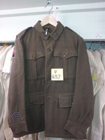
Tunic
TUNIC khaki army Wool with colour patches (RAA 1 Aust. Corps, Land H Q.)uniform, 1949, army -
 Bendigo Historical Society Inc.
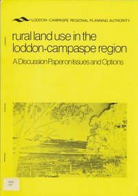
Book - RURAL LAND USE IN THE LODDON-CAMPASPE REGION, 1976
RURAL LAND USE IN THE LODDON-CAMPASPE REGION - a discussion paper on issues and options. 30 pages, with maps.Loddon-Campaspe regional planning authoritybook, rural, land use, loddon campaspe, rural, land use, agriculture -
 Bendigo Historical Society Inc.
Document - TED BEATTIE COLLECTION: INFORMATION SHEET, Pre 1980s
Information sheet 'Bendigo - where to go and what to see gold centre victoria - land of the welcome stranger' -
 Bendigo Historical Society Inc.
Document - JOHANSON COLLECTION: MORTGAGE MRS CATHERINE STUART RICHARDS
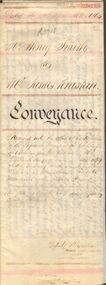
Conveyance of land from Mr Henry Smith to Mr. James Penistan. Dated 22 April 1864.bendigo, land sales, mr. henry smith to mr. james penistan, henry smith, james penistan. -
 Bendigo Historical Society Inc.
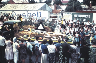
Slide - BENDIGO EASTER PROCESSION, Apr 1961
Slide.BENDIGO EASTER PROCESSION. Goornong Senior Young Farmers Club float depicting produce grown on the land.slide, bendigo, bendigo easter procession, bendigo easter procession -
 Dutch Australian Heritage Centre Victoria
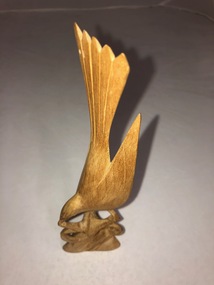
Wooden Bird Carving
Small pale wooden carving of a bird about to land on a tree branch which forms the carving's base. -
 Uniting Church Archives - Synod of Victoria
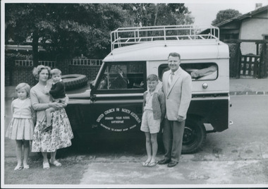
Photograph, Thomas Verrier & family, 1962
Thomas Verrier (ordained 1961): Sprent (Tas.) (HM) 1956–60; Katherine (NT) 1962–65; Nightcliff (Darwin) 1966–67; Bendigo North 1968–71; Burnie (Tas.) 1971–76; Bayswater & Wantirna 1977–?.Thomas Verrier and family standing alongside the Land Rover ready to depart for Uranium Fields Patrol Katherine.Rev. Thomas Verrier and family before departure for Katherine.verrier, thomas -
Whitehorse Historical Society Inc.
Article, Proposal to rezone land, 1992
Nunawading Council proposes to rezone land in Vermont South from public open space to restricted business.Nunawading Council proposes to rezone land in Vermont South from public open space to restricted business.Nunawading Council proposes to rezone land in Vermont South from public open space to restricted business.city of nunawading, rundle, geoff, grigg, vernon, local laws, vermont south -
Whitehorse Historical Society Inc.
Document, Certificate of title, 28/02/1924 12:00:00 AM
Certificate of Title for c. 3 acres of land east of Mitcham Road owned by Mary Theresa KirkpatrickCertificate of Title for c. 3 acres of land east of Mitcham Road owned by Mary Theresa KirkpatrickCertificate of Title for c. 3 acres of land east of Mitcham Road owned by Mary Theresa Kirkpatrickmitcham road, mitcham -
 Whitehorse Historical Society Inc.
Document, Map of Vermont & Mitcham
Copy of map showing land in Mitcham and Vermont areasCopy of map showing land in Mitcham and Vermont areas bounded by Whitehorse , Mitcham, Canterbury and Heatherdale roads.Copy of map showing land in Mitcham and Vermont areasland subdivision, whitehorse road, mitcham, heatherdale road, canterbury road, vermont, mitcham road -
 Whitehorse Historical Society Inc.
Document, Crown Allotment
Land documents relating to Crown Allotment 116 Shady Grove Nunawading Parish of Nunawading County of BourkeLand documents relating to Crown Allotment 116 Shady Grove Nunawading Parish of Nunawading County of BourkeLand documents relating to Crown Allotment 116 Shady Grove Nunawading Parish of Nunawading County of Bourkeland titles, holmes, dave, shady grove nunawading no.76, helen, jobbins, thomas, the freehold investment and banking company of australia ltd, wilson, david duncan butchart, boyle, walter, holbery, emily rachel, fisher, james cowley morgan -
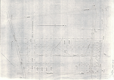
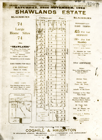 Whitehorse Historical Society Inc.
Document, Shawlands Estate, 22/11/1924 12:00:00 AM
Notice of Sale of land Holland Road and Canterbury RoadNotice of Sale of land Holland Road and Canterbury Road Blackburn Original in Haughton Maps LaTrobe LibraryNotice of Sale of land Holland Road and Canterbury Road land subdivision, canterbury road, blackburn south, holland road, shawlands avenue, coghill & haughton, shawlands estate, haughton map collection, state library of victoria. latrobe library -
Whitehorse Historical Society Inc.
Document, Healesville Freeway Reservation, 2013
Renewal project encompassing three land use concepts.Renewal project encompassing three land use concepts: Shared pathway, Davy Lane and Community use.Renewal project encompassing three land use concepts.healesville freeway reservation, vicroads -
Whitehorse Historical Society Inc.
Article, Blackburn North, 2013
Real estate advertisement for former orchard block of land in Blackburn North.Real estate advertisement for former orchard block of land in Blackburn North. Agent: Woodards. Aerial photo.Real estate advertisement for former orchard block of land in Blackburn North. surrey road blackburn north, no. 59-67, cock, herbert, junction road blackburn north -
Whitehorse Historical Society Inc.
Photograph - Illustration, Stephen Creek, n.d
Photo of Stephen Creek,1836 - 1908, early land holder who arrived in box Hill in 1856.Photo of Stephen Creek,1836 - 1908, early land holder who arrived in box Hill in 1856.Photo of Stephen Creek,1836 - 1908, early land holder who arrived in box Hill in 1856.creek, stephen, pioneers