Showing 1315 items matching "looking west"
-
 Bendigo Historical Society Inc.
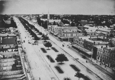
Photograph - STEREOSCOPE SANDHURST, c. 1860s
... Sepia stereoscope photographs of Sandhurst, looking West... of Sandhurst, looking West from where Gravel Hill School now stands ...Sepia stereoscope photographs of Sandhurst, looking West from where Gravel Hill School now stands. History of photograph: Printed on reverse 'Royal Historical Society of Victoria, Bendigo Branch' purple circular stamp. In blue pen in centre of stamp '1959' and '36'.place, landscape view, sandhurst -
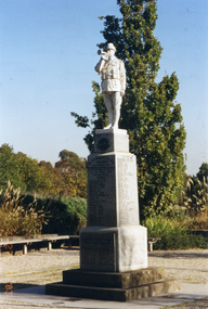 Whitehorse Historical Society Inc.
Photograph, Mitcham War Memorial, 27/05/2003 12:00:00 AM
... Park, Mitcham Road, Mitcham. View from east looking west. Part... from east looking west. Part of description of Blackburn ...Coloured photograph of Mitcham War Memorial in Halliday Park, Mitcham Road, Mitcham. View from east looking west. Part of description of Blackburn & Mitcham War Memorials prepared by Ted Arrowsmith for inclusion in War Memorials of Australia data base. See ND4383war memorials, halliday park, mitcham, arrowsmith, ted, war memorials in australia database -
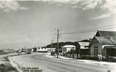 Lakes Entrance Historical Society
Postcard - Lakes Entrance, 1940c
... , looking west. Buildings identified are the Club Hotel... of Esplanade, looking west. Buildings identified are the Club Hotel ...From a wallet of miniature postcards produced by H D Bulmer for sale to touristsBlack and white small format post card of Esplanade, looking west. Buildings identified are the Club Hotel, Mitcheleson's Fancy Goods, Coate Bros Garage (later Crawford's), Broomes Auto Park, John's Milk Bar, Methodist Manse. Lakes Entrance VictoriaThe Esplanade Lakes Entrancetownship, roads and streets, retail trade -
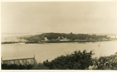 Lakes Entrance Historical Society
Photograph - The Entrance, 1910c
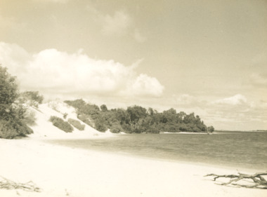
... Lakes from ocean- Bass Strait, looking west towards Western Pier... Strait, looking west towards Western Pier and dunes. Foreground ...also copies|Two black and white 8.5 x 14|Two black and white 16 x 25Sepia photograph showing view of entrance to Gippsland Lakes from ocean- Bass Strait, looking west towards Western Pier and dunes. Foreground on left shows gable roof of rocket shed and shipwreck bell on white post on right. Lakes Entrance Victoriawaterways, sandbar, rocket shed -
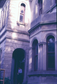 Kew Historical Society Inc
Slide - Villa Alba entrance porch, 1987
... the east, looking west. The bay window of the drawing room... the east, looking west. The bay window of the drawing room ...Built for William and Anna-Maria Greenlaw in the early 1880s, and with interiors decorated by the Paterson Bros, Villa Alba remained in private ownership until 1949. From 1950, the house was owned by a number of institutions. By 1984, the Villa Alba Preservation Society had been formed, and three years later, the Mount Royal Hospital granted a 25-year lease to Kew Council. In 2004, the title to Villa Alba was passed by the Victorian Government to The Villa Alba Museum Incorporated. Digital copy of a olour 35mm slide, framed in a plastic mount, of the portico of Villa Alba, 44 Walmer Street, Kew, 3101. The transparency shows the grey rendered tower and entrance, viewed from the east, looking west. The bay window of the drawing room is in the foreground."Villa Alba Exterior 1987"villa alba museum, mount royal hospital, historic houses -- kew (vic.), victorian architecture -- melbourne (vic.) -
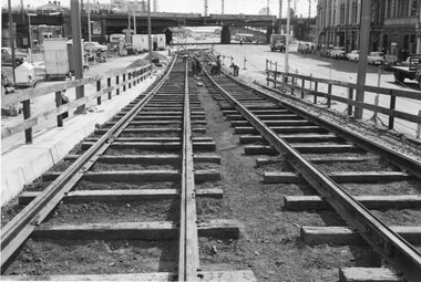 Melbourne Tram Museum
Photograph - Black & White Photograph/s, Melbourne & Metropolitan Tramways Board (MMTB), Nov. 1959
... overpass in Flinders St. looking west. shows work being completed... of the construction of the King St overpass in Flinders St. looking west ...Black and white photographs of the temporary track being completed during the first stage of the construction of the King St overpass in Flinders St. looking west. shows work being completed. Reg Item 4274 by Keith Kings dates the work to mid Nov. 1959.Some photos have pencil marks on rear.trams, tramways, trackwork, rails, track materials, track repairs, sleepers, equipment, flinders st, king st, kingsway -
 Lakes Entrance Historical Society
Photograph - Sand hummocks Lakes Entrance Victoria c1952, L Carpenter, 1952 c
... taken from sand hummocks looking west down Cunninghame Arm c1952... hummocks looking west down Cunninghame Arm c1952 Photograph Sand ...Black and white photograph of an area of the sand hummocks known locally as Hill 60 Sandy beach and lake in foreground Lakes Entrance Victoria. Also two black and white photographs taken from sand hummocks looking west down Cunninghame Arm c1952 township, topography, gippsland lakes, sand dunes -
Tatura Irrigation & Wartime Camps Museum
Photograph - original, Hogan Street Tatura c 1950's, 1950's original
... Original photograph of Hogan Street, Tatura. Looking west.... Looking west. Memorial clock in foreground. Palm tree on right ...Original photograph of Hogan Street, Tatura. Looking west. Memorial clock in foreground. Palm tree on right. Photograph on greeting card. Handkerchief originally enclosed.Original photograph of Hogan Street, Tatura. c 1950's. Black and white photograph.on back: a gift handkerchief with best wishes from Tatura -
 Eltham District Historical Society Inc
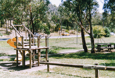
Photograph, Homestead Road, Eltham Lower Park
... Eltham Lower Park, looking south west across playground... hohnes hill Eltham Lower Park, looking south west across ...Eltham Lower Park, looking south west across playground area to Homestead Road, date unknowneltham lower park, parks, reserves, playgrounds, trees, eltham, hohnes hill -
 Eltham District Historical Society Inc
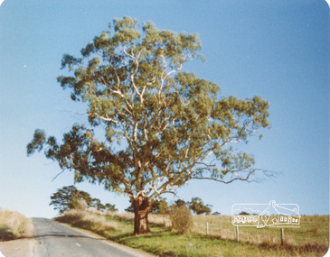
Photograph, Peter Bassett-Smith, White Gum, Main Road Eltham-Yarra Glen, Kangaroo Ground, June 1977, 1977
... Directory Map 23 D1) looking west approximately 1 mile from Kangaroo... Road, Eltham-Yarra Glen (Melways Directory Map 23 D1) looking ...Colour photograph of a Eucalyptus Viminalis (White Gum or Ribbony Gum or Manna Gum) on Main Road, Eltham-Yarra Glen (Melways Directory Map 23 D1) looking west approximately 1 mile from Kangaroo Ground approx. opposite Andy Avard's gate.eltham yarra glen road, kangaroo ground -
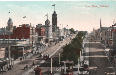
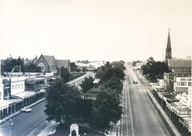 City of Ballarat Libraries
Photograph - Card Box Photographs, View west along Sturt Street, Ballarat circa 1935
... Taken from Doveton Street North looking west. The George... Ballarat East goldfields Taken from Doveton Street North looking ...Taken from Doveton Street North looking west. The George 5th Statue, St Andrews Kirk, St Patrick's Cathedral and the Alexandra Bandstand can be seen.doveton street north, sturt street, king george 5th, st andrews kirk, st patricks cathedral, alexandra bandstand, gardens, public, statue, commerical, church -
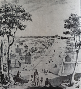 Ballarat Heritage Services
Photograph - Image, Collins Street, Melbourne in 1840, 1840
... Image of Collins Street Melbourne in 1840, looking west... Image of Collins Street Melbourne in 1840, looking west towards ...Image of Collins Street Melbourne in 1840, looking west towards Russell Street, from a drawing by Elisha Noyce and William Knight, August 1840. The original worko is held by the State Library of Victoria. A group of Aborigines stand in the foreground. From the State Library of Victoria's Pictures Collection. collins street melbourne, melbourne, aborigines -
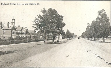 Ballarat Tramway Museum
Postcard, Ballarat Orphan Asylum and Victoria St
... looking west with a tram at the terminus and the tramway overhead... and Victoria St looking west with a tram at the terminus ...Yields information about the corner of the Victoria St terminus at the Orphanage and the relationship to the tramway.Digital Image of the Ballarat Orphan Asylum and Victoria St looking west with a tram at the terminus and the tramway overhead poles. Titled "Ballarat Orphan Asylum and Victoria St" From the Facebook group of old time photographs of yesterday. Probably taken soon after the tramway opened in 1905.trams, tramways, victoria st, orphanage, esco, postcards, tram 1 ? -
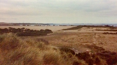 Phillip Island and District Historical Society Inc.
Photograph, Forrest Caves, 1980s
... dunes looking south west across Island.... dunes looking south west across Island. Forrest Caves Photograph ...4 coloured photos of Forrest Caves beach and view from dunes looking south west across Island.photographs, forrest caves phillip island -
Tatura Irrigation & Wartime Camps Museum
Photographs, Hogan Street Tatura
... 1. Hogan Street looking west from railway crossing c.1900... Tatura the-murray 1. Hogan Street looking west from railway ...1. Hogan Street looking west from railway crossing c.1900.|2. Hogan Street looking east from Ross Street, c.1900, Flanagan's Store.2 photos -
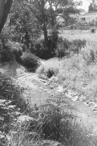 Ringwood and District Historical Society
Photograph, Mullum Creek, 50 yards west of bridge in Ringwood Street Ringwood. May 1971
... ." Enlargement reads, "Mullum Creek looking west from bridge in Ringwood... in Ringwood St." Enlargement reads, "Mullum Creek looking west from ...Writing on back of small photograph reads, "May 1971. Mullum Creek, 50 yards west of bridge in Ringwood St." Enlargement reads, "Mullum Creek looking west from bridge in Ringwood St. July 1972". -
![Construction of the electric tram line in Cotham Road [Kew]](/media/collectors/550653872162f11fb04854aa/items/662870846214a76cee3aecf0/item-media/662870de6214a76cee3af7de/item-fit-380x285.jpg) Kew Historical Society Inc
Kew Historical Society IncPhotograph - Construction of the electric tram line in Cotham Road [Kew], E.J. Dower, 1913
... in Cotham Road Kew, looking west / Taken from corner of Burke Road... trams in Cotham Road Kew, looking west / Taken from corner ...One of a small album of six photographs of the construction of the Cotham Road tramline in Kew, taken by Edgar James Dower in the second decade of the twentieth century. The reverse of each photo contains notes, written over time by the photographer, which are contained in the 'Inscriptions' field. Born and raised in Olinda, Dower's family later moved to Surrey Hills. He worked as an adult as a clerk in the city office of the Metropolitan Gas Company, and in his role as a 'collector', he was able to photograph scenes including the construction of tram and train lines and associated buildings in Kew, Hawthorn, Camberwell and Surrey Hills. Later he established a real estate agency with his brother - the E.J. Dower Real Estate Agency, Dandenong Office. The album as a whole can be viewed separately as the parent file.The image is an historically significant record of the development of transport infrastructure which was used to connect Victorians in the first two decades of the twentieth century. This development resulted from increases in population and the consequent extension of Melbourne's suburbs. The photographs in the album, as well as Dower's single photos mounted on card, individually and collectively richly detail the labour of workers and the tools and machinery used to create and extend Melbourne's tram and train networks in the years preceding and during World War 1.The first of six annotated photos in an album of photographs of the construction of the St Kilda to Kew electric tram line, taken in Cotham Road, Kew, by the amateur photographer, Edgar James Dower, in 1913. The album contains images detailing the preparation for the laying of the tracks plus work laying the line. The photographer notes on a number of the photos that te metal tracks were collected from the Hawthorn railway siding. The album, together with other phots by E.J. Dower has been made available by the owners for the Kew Historical Society to digitise and publish online and in print.Annotation verso: "1913 / Preparing for electric trams in Cotham Road Kew, looking west / Taken from corner of Burke Road by E.J. Dower / The metal was brought by horse and drays, from Hawthorn rail-way siding".keywords, theme -- connecting victorians by transport and communications, theme -- travelling by tram, photographers -- edgar james dower, cotham road -- kew (vic.) -
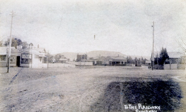 Sunbury Family History and Heritage Society Inc.
Photograph
... and Evans Street looking west and towards Sunbury Station. Mount... Street looking west and towards Sunbury Station. Mount Holden ...The post card is an early view of the intersection of Brook and Evans Street looking west and towards Sunbury Station. Mount Holden is in the distance. Chris Christianson's shop is on the LHS of the picture with the post office on the RHS. This image is an early view of Sunbury town centre with the railway station and post office. Like many country towns of this era, The roads have been formed but not surfaced. A sepia photograph in post card format of a view of a town centre showing an intersection and some small buildings with a hill in the distance.TO THE RAILWAY/SUNBURYbrook street, evans street, sunbury railway station, christianson, chris. -
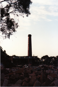 Whitehorse Historical Society Inc.
Photograph, Vitclay, 1995
... by demolished sheds. Springfield Road, Blackburn North, looking North..., Blackburn North, looking North-West. Vitclay Photograph Photograph ...Vitclay Chimney, prior to demolition in 1995, surrounded by demolished sheds. Springfield Road, Blackburn North, looking North-West.vitclay, springfield road, blackburn north, potteries, clay industries -
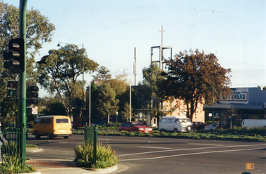 Whitehorse Historical Society Inc.
Photograph, Whitehorse Road, Mitcham
... and Station Street looking north-west toward the Anglican Church... of the corner of Whitehorse Road and Station Street looking north-west ...Coloured photograph of the corner of Whitehorse Road and Station Street looking north-west toward the Anglican Church, taken 2003whitehorse road, mitcham -
University of Melbourne, Burnley Campus Archives
Photograph - Black and white print, 672/1, 1947
... "Late Sept 1947. Note P. sinensis alba. Looking S. West... collection "Late Sept 1947. Note P. sinensis alba. Looking S. West ..."Late Sept 1947. Note P. sinensis alba. Looking S. West across Lily pond lawn." THKlily ponds, lawns, e. m. gibson collection -
 City of Ballarat Libraries
Photograph, Western view from Ballarat Town Hall Tower 1899
... View from the Ballarat Town Hall Tower looking west... looking west. Buildings that can be seen are William Dawson ...View from the Ballarat Town Hall Tower looking west. Buildings that can be seen are William Dawson Ironmonger and Walter Cornell Chemist. The slate roof of St Andrew's Kirk can also be seen.ballarat town hall tower, gardens, william dawson, walter cornell, commercial, st andrew's kirk, ballarat, ironmonger, chemist, church, sturt street -
 Orbost & District Historical Society
black and white photographs, C 1970s
... 3288.1 has been taken in Lawson Lane, Orbost, looking west... gippsland 3288.1 has been taken in Lawson Lane, Orbost, looking west ...3288.1 has been taken in Lawson Lane, Orbost, looking west from the rear of the Shire Offices. 3288.2 has been taken in Lawson Lane, Orbost, looking east from the rear of the Shire Offices.These photographs are pictorial records of the Orbost township C 1970s.Two black / white photographs showing cars parked on an unsealed road with buildings in the background.lawson-lane-orbost streets-orbost-1970s -
Tatura Irrigation & Wartime Camps Museum
Photograph, Old Saleyards 1927
... demolition. Looking west along Hogan Street, Tatura. New saleyards... during demolition. Looking west along Hogan Street, Tatura. New ...Original photograph of McNamara's saleyards during demolition. Looking west along Hogan Street, Tatura. New saleyards were established on land bordered by Ross Street, O'Toole Street, Maher Street and O'Reilly Roadl.Black and white photograph of old saleyards being demolished, Hogan Street, Tatura. Exterior. Approx. 1927.McNamaras old saleyards being demolished.old saleyards tatura -
 Ballarat Tramway Museum
Photograph - Black and White - tram 17 Victoria St and East St, A T Miles, 30/1/1968
... with East St, looking west. Shows the curve in Victoria St, just... (Victoria St) at the intersection with East St, looking west. Shows ...Black and White - tram 17 (Victoria St) at the intersection with East St, looking west. Shows the curve in Victoria St, just before the descent to Bridge St, Taken by A T Miles 30/1/1968.Yields information about the Victoria St route.Photograph - black and white print with notes on rear. Printed on Ilford paper.A T Miles stamp and location and date notes.tramways, trams, tram 17, victoria st, east st -
 Ballarat Tramway Museum
Slide - 27 mm sq slide/s - set of 3, Lilian Butler, Sturt St and Ripon Sts, 1971
... Point line junction at Ripon St, looking north west with short.... (Advised by Neville Britton 26/9/2016 - by e-mail) 3 - looking west ...Yields information about Ripon St, Talbot St.Set of 3 Hanimex slides - what cardboard mounts: 1 - View Point line junction at Ripon St, looking north west with short tram stop pole and Ampol service station sign on the right. 2 - Water column North West corner of Sturt Street and Talbot Street (opposite the Fire Station). Column long gone. (Advised by Neville Britton 26/9/2016 - by e-mail) 3 - looking west - South side of Sturt St. Photo from the collection of Lilian Butlerballarat, tramways, trams, sturt st, view point, ripon st, tram stops -
 Ballarat Tramway Museum
Postcard, Valentine & Sons Publishing Co, "Sturt Street Ballarat:", c1912
... of the Nichol and Allen Building in Grenville St looking west. Titled... in Grenville St looking west. Titled "Sturt St Ballarat" in the top ...Valentine Series postcard of Postcard, looking from the top of the Nichol and Allen Building in Grenville St looking west. Titled "Sturt St Ballarat" in the top left-hand corner. Has two ESCo trams in the view, with a 3rd outside the town hall. Shows all the buildings on both sides of Sturt St, many flying prominent flags. Postcard by Valentine & Sons, printed in Great Britain. In a note to Ken Magor, Wal Jack has written on the rear: "old type, No. 17 on left and No. 11 on right. Photo taken from Grenville Street looking west about 1912." Yields information about Sturt St looking west from Grenville St about 1912.Postcard, colour, divided back, with a handwritten note on rear.See image 2 for the handwritten note on the rear. tramways, trams, sturt st, postcards, grenville st, tram 17, tram 11, esco -
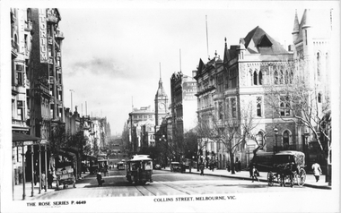 Melbourne Tram Museum
Postcard, Rose Stereograph Co, "Collins Street Melbourne", c1915
... Melbourne", looking west from Russell Street. Has several of cable...", looking west from Russell Street. Has several of cable trams ...Rose Series postcard No. P 4649 titled "Collins Street Melbourne", looking west from Russell Street. Has several of cable trams in the view along with many horse-drawn carts and some motor cars. Yields information about Collins St c1915Postcard - printed real photograph with Rose Stereograph Co. name on the rear.Has the Ken Magor stamp on the rear.trams, tramways, cable trams, collins st. -
 Whitehorse Historical Society Inc.
Photograph, Britannia Street, Mitcham, c. 1987
... , looking south west, showing the Guide Hall (left) and Anglers club...., Mitcham, looking south west, showing the Guide Hall (left ...Black and white photograph of Britannia St., Mitcham, looking south west, showing the Guide Hall (left) and Anglers club (right)britannia street, mitcham, mitcham guide hall, mitcham angling club -
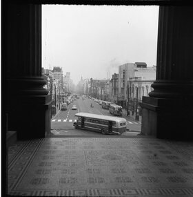 Ballarat Tramway Museum
Photograph - Black & White Photograph/s, Geoff Grant, 16/06/1955 12:00:00 AM
... of Parliament House looking west on 16 June 1955, a few days before... inside pillars of Parliament House looking west on 16 June 1955 ...View of Bourke Street Melbourne from just inside pillars of Parliament House looking west on 16 June 1955, a few days before the trams took over. MMTB Bus 580 turning into Bourke St from Spring St. Negative scanned hi res and imaged updated 20/5/2020.On rear in typed on paper "Buses inn Bourke St. A shot taken a few days before the trams took over. Taken from Parliament House steps 16 June 1955." & "Geoff Grant etc." stamp in btm rh corner.trams, tramways, melbourne, bourke st