Showing 2525 items matching "melbourne water."
-
 Kiewa Valley Historical Society
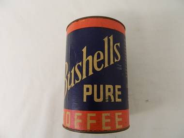
Tin Bushells, after 1937
Bushells tea and coffee producers started in Brisbane(1883) and expanded to Sydney, Melbourne(1899), Fremantle and finally to Auckland(1937). Like other Pacific Island sourced condiments Tea and coffee were a lot easier to import than British or European goods. Local Australian industries were starting to develop and grow to overcome the long transportation times and the high costs of goods from traditional suppliers. Bushells Pty Ltd is a prime example.This "Bushells" Coffee tin is a good example of Australian "grown" condiment suppliers serving the "whole" of the Australian marketplace. Rural areas were not neglected and the purchase price for goods were a reasonable levels. Kiewa Valley experienced a population growth from the late 1940's and due to the migrant works in the Kiewa Hydro Scheme the greater use of coffee was initiated. Rural areas, on the whole, where the population was more connected to some degree with a British heritage lineage were predominately tea drinkers. The American film productions, however, screened in Australia post 1950's showing a greater degree of coffee drinking "stars" had a long term effect upon the drinking habits of the rural populous. This round tin of coffee with lid is made from pressed steel lid framed top and bottom. Sturdy cylindrical body is made of cardboard. Paper information label is pasted onto the container with promotional and logo information.In large print and on opposite sides are two manufacturers labels.The topprint and on a diagonal slant in gold letters on a dark blue background is "BUSHELLS" underneath this "PURE" and below this on a red background "COFFEE". On one side in smaller print "EASY TO MAKE" and below this "Use one dessert-spoonful for each cup of coffee desired. Place in the pot and pour over it fresh water briskly boiling. Let stand for five minutes, then strain". Below this "1 IB. net" and underneath is a signature "BUSHELLS" below this in small print "Pty. Ltd." Below this, in a vertical row are"SYDNEY MELBOURNE fREMANTLE AUCKLAND"coffee and tea processors and distributors, hot drink suppliers -
 Kiewa Valley Historical Society
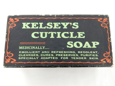
Box Cuticle Soap, mid to late 1900's
The mid 1900's provided the start of "the body beautiful" revolution. The cosmetic industry, with the help of quasi scientific selling advertising slant targeted those "customers" that needed the "extra care" factor that only their product could offer. At this period in time their advertising power was based on in store, radio and newspaper media channels with saturation levels relatively low. In the later years of the 1900's saturation levels and a wider range of products and increased competition further increased the product saturation levels available to the buying residents. With the introduction of television the advertisements become more elaborate and "catchy" words, phrases and comedy type situations helped boost the advertising "pitch" and subliminal undertones to effective levels required for a highly competitive health related market place. 'sellingThis subliminally,"medically" endorsed product was one of many during the great "spin" revolution of product marketing and selling. This item is significant in that it demonstrates that greater infusion of product awareness throughout rural areas was highly successful through a greater variety of advertising media. It also demonstrates that in a highly competitive marketplace there are no physical boundaries that impinge upon the distribution of products and services. The rural sector is a highly lucrative region for any product that helps protect the body from all the "nasty's" that become more noticeable in a rural environment. This rectangular box which had contained cuticle soap is constructed from cardboard and reinforced by a black nylon impregnated sheeting. This impregnation was required to keep the box from soaking up any water from the user's hands. The top section of the box(lid) has and in large print "KELSEY'S" top line followed by "CUTICLE" off to the right and underneath and to the right "SOAP". Below this and in smaller print is "MEDICINALLY..." below this and in smaller print "EMOLLIENT AND REFRESHING, REDOLENT, CLEANSES, CURES, PRESERVES, PURIFIES." and last line underneath "SPECIALLY ADAPTED FOR TENDER SKIN" On each of the sides of the top lid are, side 1 "INVALUABLE FOR THE NURSERY." underneath in smaller print "JOHN M. KELSEY CO." to the left of this and on a green backed highlighter "No. 1744 - Guaranteed under Pure Food Act, 1908, N.S.W. by John M. Kelsey Co. - No. 1744. Melbourne, Victoria." On the right side and in large print "KELSEY'S CUTICLE SOAP" on the next side and also a similar sign on the opposite side "SPECIALLY ADAPTED FOR TENDER SKIN." below this "JOHN M. KELSEY CO." "Registered" and on the other long side in large print "SPECIALLY ADAPTED FOR TENDER SKIN" underneath in smaller print JOHN M. KELSEY CO. Registered"specialised soap, toilet requisites, nursery health., bathroom, domestic -
 Kiewa Valley Historical Society
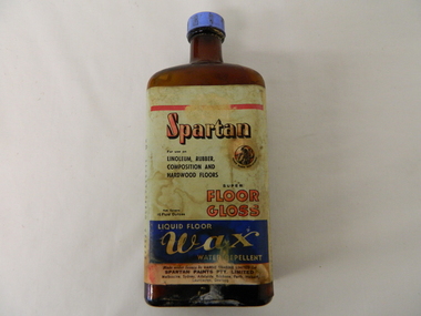
Bottle - Liquid Wax, mid 1900's
This bottle of liquid floor polish was manufactured before 1960(taken over by Wattyl) in a period when most of the floors in high traffic areas were covered in linoleum. Most of the floors using this product during this period would have been kitchens and laundries. During this period the cleanliness of the kitchen, hallways and eateries had to appear clean (cleanliness was a sign of a bacteria free area). This was a priority for kitchens, mess areas(SEC Hydro Scheme facilities) and connecting walkways. The cleanliness attitude was enhanced in the rural areas due to the "dirty" farm work not impinging upon the residential home.When Mount Beauty was first inhabited all the residential and worker's facilities were a prime area for linoleum floor surfaces. The liquid floor polish was in great demand, "a polished floor is a clean floor".This bottle of liquid floor polish is very significant to the Kiewa Valley, not only that it covers the floors of every home and residential barracks of the first major development of a "town" now known as Mount Beauty but also it demonstrates that the "cleanliness" approach of early Australians living areas in the rural regions was "on par" with its city cousins. It is the smaller types of mores that underlie the "mushrooming" cultural and psyche "wholeness" of an ever expanding Australian culture.This brown opaque glass bottle with an oblong shape has a blue coloured "screw on" cap. It has a "wrap around" label glued firmly on the bottle and covers the front and sides.On the front main label under a red line, "SPARTAN" underneath in smaller print "For use on" below this, "LINOLEUM, RUBBER, COMPOSITION AND HARDWOOD FLOORS" besides this is an encircled Trade Mark of a "Spartan Warrior holding a spear and shield" these word follow the curviture of the circle and are below it "TRADE MARK REGISTERED" Below this are "SUPER FLOOR GLOSS" to the left in very small print "Nett Contents 16 Fluid Ounces". Below this on a blue background and in white print"LIQUID FLOOR WAX WATER REPELLENT". On the bottom of the label "Made under licence by HARDIE TRADING LIMITED for SPARTAN PAINTS PTY, LIMITED" below this in small print "Melbourne, Sydney, Adelaide, Brisbane, Perth, Hobart, Launceston, Geelong. Embossed on the bootm of the glass is" G/Mfloor cleaners, liquid polish, "hygienic" clean floors. -
 Kiewa Valley Historical Society
Tester Direct Current, mid 1900's
This tester was used between 1950 and 1980's. As part of the Occupation, Health and Safety requirements, equipment used to monitor the performance of electricity producing generators, regularly, hand held testers were used to check the insulation and the "earth" pin were up the the required operational levels. As the generators and their ancillary monitoring equipment was spread over a large area and cumbersome to service small hand held devices were required. These had to always be safe for the user to operate. A selected range of high quality meters were recalibrated every two years in the Meter and Calibration Laboratory at Yarraville(near Melbourne) This meter is very significant to The Kiewa Hydro Electricity Scheme because it was an integral part of maintaining the electricity producing water driven generators of the power stations. The reason why this meter was so essential is that provided the safety check on equipment used to monitor each Hydro Generator that they were complying within the grid network parameters. Grid parameters are set so that if there is an electrical fault on the system, that fault can be attended to with a very small change in the output stability of each generator. It is essential that the voltage of the network remain within the set limits. Generators are at Dartmouth, Mackay, Clover, West Kiewa, Yarrawonga, Cain Curran and three Power Stations in the Thornton area.This hand driven current generator produces 500 volts by winding the handle(on funnel curved side) to keep the voltage constant(one minute per test). The whole body is made from caste aluminium. One of the functions of this meter is to test the isolation resistance of any equipment being tested. This is to see if that equipment is safe to handle(no electrical shocks). The second function is to test the earth pin of any portable electrical equipment. The turn key on one side can direct which function is required(marked insulation or continuity). On the top side(enclosed in a glass fronted marked scale) is a continuity scale(top) and an insulation scale(bottom). This is covered , when not in use by "flip up" lid with manufacturer's details and name of the instrument. Opposite the winder are two screw tight knobs. One marked earth(left side) and one marked line(right side). On the top and next to the glass windowed scales in a post manufacture SEC Vic equipment equipment ID number. For carrying purposes there is chromed steel (fold together) handle.The bottom of the unit has two metal "feet" 150mm long by 114mm wideManufacturer's details on top side "MEG" underneath "INSULATION AND CONTINUITY TESTER" below this "constant 500 VOLT pressure" below this "REGISTERED MEG MEGGER TRADE MARK" below this "REG DESIGN NO. 690326" below this "UNITED KINGDOM PATENT Nos. 193746, 197178, 198182, 202062, 202398, 204649, 350715" below this "SUPPLIED BY THE GENERAL ELECTRIC Co. Ltd OF ENGLAND" below this "MAGNET HOUSE, KINGSWAY LONDON W.C.2" 'sec vic kiewa hydro scheme, alternate energy supplies, alpine feasibility studies temperature, rainfall -
 Kiewa Valley Historical Society
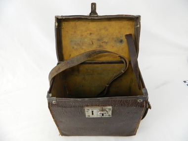
Case leather
This case was used between 1950 and 1980's. As part of the Occupation, Health and Safety requirements, equipment used to monitor the performance of electricity producing generators, regularly, hand held testers were used to check the insulation and the "earth" pin were up the the required operational levels. As the generators and their ancillary monitoring equipment was spread over a large area and cumbersome to service small hand held devices were required. These had to always be safe for the user to operate. A selected range of high quality meters were recalibrated every two years in the Meter and Calibration Laboratory at Yarraville(near Melbourne)This leather case contains a meter which is very significant to The Kiewa Hydro Electricity Scheme because it was an integral part of maintaining the electricity producing water driven generators of the power stations. The reason why this meter was so essential is that provided the safety check on equipment used to monitor each Hydro Generator that they were complying within the grid network parameters. Grid parameters are set so that if there is an electrical fault on the system, that fault can be attended to with a very small change in the output stability of each generator. It is essential that the voltage of the network remain within the set limits. Generators are at Dartmouth, Mackay, Clover, West Kiewa, Yarrawonga, Cain Curran and three Power Stations in the Thornton area.This carry case is made from leather hide and cloth covered cardboard insert. The front side has a lockable English made suitcase fitting. It has a broken carry strap (leather) travelling from top and through leather strap holders both sides and on the bottom of the case. A State Electricity Commission of Victoria identification tag riveted onto the top lid "ELECTRICAL ENGINEERING SECTION No. 1483"sec vic kiewa hydro scheme, alternate energy supplies, alpine located electricity generators, mobile measuring equipment -
 Eltham District Historical Society Inc
Photograph, George W. Bell, Christmas Hills bushfire, Jan. 1962, Jan 1962
Building of Pensioners Cottages at St Andrews; for those burnt out in the 1962 bushfires. A voluntary scheme of Mavis Gill through the Kangaroo Ground Relief CommitteeBlack and white photo mounted on cardChristmas Hills bushfire Photo Geo. W. Bell, Jan. 1962victorian bushfires - 1962, bushfires, fire damage - buildings, george w bell, houses, st andrews, mavis gill, pensioners cottages, christmas hills, water tank -
 Eltham District Historical Society Inc
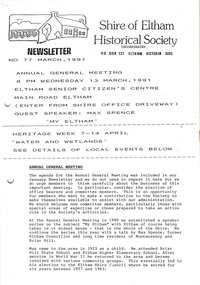
Newsletter, Newsletter, No. 77 March 1991
Contents: • Next meeting, guest speaker; Max Spence: My Eltham • Annual General Meeting • Heritage Week – Water and Wetlands • 1991 Photo Project • Eltham R.S.L. • Society Program The Shire of Eltham Historical Society was formed in October 1967. The first newsletter of the Society was issued May 1978 and has been published continuously ever since on a bi-monthly basis. With the cessation of the Shire of Eltham in late 1994, the Society's name was revised to Eltham District Historical Society and this name first appeared with issue No. 103, July 1995. The collection of the Society's newsletters provides a valuable resource on the history of the Society's activities, office bearers and committee members, guest speakers and subjects of historical interest pertinent to the former Shire of Eltham and the Eltham District.A4 photocopied newsletter distributed to membersnewsletter, eltham district historical society, shire of eltham historical society -
 Eltham District Historical Society Inc
Photograph, View of water tower and industrial area, Candlebark Court, Research
Colour photographcandlebark court, research (vic.), water tower -
 Eltham District Historical Society Inc
Photograph, Liz Pidgeon, Heritage Excursion; Eltham Lower Park Walk and Talk, 1 July 2017, 1 July 2017
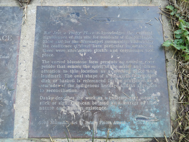
Transcription of plaque: Not Just a Pretty Place acknowledges the cultural significance of this site for residnets of the Nillumbik Shire and for the Wurundjeri community. Historically the confluence of rivers have particular importance as these were sites where rituals and ceremonies took place. The carved bluestone form presents an oversize river pebble that echoes the spirit of the water and draws attention to this location as a meeting place and landmark. The oval shape of a coolamun (Wurundjeri dish or basket) is referenced in the sculpture as a reminder of the indigenous heritage and as a gesture to reconciliation Danko describes the work as a contemporary message stick or sign, that can be read as a merker of time, nature and human existance. 2000 Nillumbik Art in Public Places Award. Heritage Excursion - Saturday 1st July - Eltham Lower Park - Walk and Talk Eltham Lower Park has played an important part in the history of our area since the early days of European settlement when it was used by local residents as an informal racecourse. Prior to that its location at the junction of the Diamond Creek and the Yarra River made it an important meeting place for the Wurundjeri people. The park combines formal elements and sporting facilities with remnant bushland that is of environmental significance. It is home to sporting and horse riding clubs, popular play spaces and the Diamond Valley Miniature Railway, which attracts large numbers of visitors. The park will be the venue for our July excursion which will comprise a walk of about 3.5 km around the park and adjacent areas. Along the way we will discuss the history and natural history of the area. The path along the creek and the river provides a pleasant and scenic walk. This walk on Saturday 1st July is about 3.5 km in length and will take 2 to 2.5 hours. It will start at 2pm at the Main Road car park at the front of the park. (Melway ref 21 H 10). From Newsletter No., 234, June 2017 Born Digitalelection day, heritage excursion, activities, eltham district historical society, eltham lower park, not just a pretty place, public art, plaque -
 Eltham District Historical Society Inc
Photograph, Liz Pidgeon, Heritage Excursion; East of Eltham, 6 Sep 2014, 20 May 2017
Newsletter No. 218, September 2014 September Excursion - East of Eltham Walk In Newsletter No. 197, March 2011, there was a brief history of Crown Allotment 15 Section 5 Parish of Nillumbik (CA 15) a parcel of land of a quarter of a square mile extending from Eucalyptus Road to Reynolds Road at the eastern extremity of Eltham. From the 1940s it was known as Stokes orchard. In later years it has been subdivided for residential purposes but leaving significant areas as power line and water supply reserves and bushland reserves that are habitat for the threatened For our excursion on 6th September we intend to walk through CA 15 to a bushland reserve east of Reynolds Road. The walk will traverse the boundary between suburban Eltham and the non-urban areas to the south and east. This is a pleasant walk through residential areas and bushland. Along the way we will discuss the early and more recent history of CA 15 as well as local natural history and geology. This walk is about 3.5 km in length and will take 2 to 2.5 hours. It will start at 2pm at the corner of Eucalyptus Road, Pitt Street and Nyora Road.Born Digitaleltham east, eltham district historical society, heritage excursion, activities, nyora road, reynolds road, gum tree road reserve, diosma road, stokes orchard, eucalyptus road -
 Eltham District Historical Society Inc
Photograph, Liz Pidgeon, Heritage Excursion; East of Eltham, 6 Sep 2014, 20 May 2017
Newsletter No. 218, September 2014 September Excursion - East of Eltham Walk In Newsletter No. 197, March 2011, there was a brief history of Crown Allotment 15 Section 5 Parish of Nillumbik (CA 15) a parcel of land of a quarter of a square mile extending from Eucalyptus Road to Reynolds Road at the eastern extremity of Eltham. From the 1940s it was known as Stokes orchard. In later years it has been subdivided for residential purposes but leaving significant areas as power line and water supply reserves and bushland reserves that are habitat for the threatened For our excursion on 6th September we intend to walk through CA 15 to a bushland reserve east of Reynolds Road. The walk will traverse the boundary between suburban Eltham and the non-urban areas to the south and east. This is a pleasant walk through residential areas and bushland. Along the way we will discuss the early and more recent history of CA 15 as well as local natural history and geology. This walk is about 3.5 km in length and will take 2 to 2.5 hours. It will start at 2pm at the corner of Eucalyptus Road, Pitt Street and Nyora Road.Born Digitaleltham east, eltham district historical society, heritage excursion, activities, nyora road, reynolds road, gum tree road reserve, diosma road, stokes orchard, eucalyptus road