Showing 2630 items
matching otway-reef
-
 Stawell Historical Society Inc
Map, Fred W Wright Surveyor, Plan of the Borough of Stawell showing Mining leases & reefs 1870, 1870
Mining details. Including Tramways, Water Races. Crushing Mills. Reefs and Reserves.Copy of Original Showing Stawell Borough with details including mining leases Companies and MillsInsert with details of Sections 23, 34, 35 & 36. Fred W Wright 12 May 1870mining -
 Bendigo Historical Society Inc.
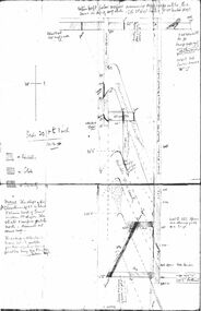
Document - CHRISTMAS REEF GOLD MINING CO. COLLECTION: PLAN OF MINE
Hand drawn plan of mine, showing spurs, slate, lava. Christmas Reef shaft and Great Western shaft drawn. Notations in pencil. On left hand side 'Memo: the shaft of the Christmas Reef Co is about 5 chains north of Great Western Cos shaft. The strata and surface pitch north, assumed at same rate. The working of Allingham and Moore's Trib Co are taken from their reports in Bendigo Advertiser May 1872 to May 1873. Jas Down Mgr' Scale on plan 20 ft to 1 inch Legend shows sandstone, slate and quartz.Bendigo Advertiserbendigo, mining, christmas reef gold mining -
Bendigo Historical Society Inc.
Map - GEOLOGICAL MAP OF BENDIGO GOLD FIELD
Two framed laminated maps (a,b) of Bendigo goldfield reef lines, map (b) is a continuation of the reef lines in map (a). On map(a) written in black on top: 'Geological Map, Bendigo Gold Field', Scale of chains, anticlines, synclines, shafts, alluvial and contours marked. Map (b) is continuation of (a). Written on the bottom RH corner of map: 'Prepared in 1923 in the Bendigo Office Mines Department under the direction of H. Herman, Director of Geological Surveys, from surveys by H.S. Whitelaw, Fiield Geologist, assisted by E.S. Usher & J. J. Moore. Re-issued in 1936.'H. Herman, Director of Geological Surveys, from surveys by H.S. Whitelaw, Fiield Geologist, assisted by E.S. Usher & J. J. Moore. Re-issued in 1936.'bendigo, mining, geological map. -
 Bendigo Historical Society Inc.
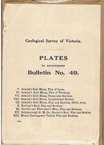
Book - MCCOLL, RANKIN AND STANISTREET COLLECTION: PLATES TO ACCOMPANY BULLETIN NO.49 MALDON GEOLOGICAL SURVEY OF VICTORIA
Book; Brown paper containers with plates (& maps) to accompany bulletin No49 of geological survey of Victoria. V Oswalds G.M. Plan of lease. VI. Oswalds G. M. Plan of workings. VII. Oswalds G. M. Transverse Sect. VIII. Oswalds G. M. Longit. Section. IX. Oswalds G. M. Plan & Sect. 500ft. Level. X. Northey's Reef plan & sections. XI. Carlisle and Whittaker's Mine Plan & Sections.XII. Goldsborough G. M. Co. Gordon's Reef, Plan & Section. XIII. Mount Tarrengower Tunnel Plan & Section.MCCOLL RANKIN & STANISTREETorganisation, industry, surveys, mccoll rankin & stanistreet -
Bendigo Historical Society Inc.
Map - MAP PORTION OF BENDIGO GOLDFIELD, Circa 1912
Map: Portion of Bendigo Goldfield showing Sheepshead, Deborah, Garden Gully, Paddy's Gully and Derby lines of reef. Showing statistical records of all the Companies on these lines. Issued by Wood and McNair, Sharebrokers, Bendigo and Eaglehawk. The map illustrates the main lines of reef as they appeared with mines and details of their calls and dividends as well as gold produced. Drawn by mining surveyor and geologist William Henry Cundy, who trained and worked for the Tasmanian Mines Department until 1893, when he moved and settled in Bendigo. Cundy was responsible for the surveying of the southern end of the field of Diamond Hill and beyond.topic, mining, companies, bendigo goldfield, sheepshead , deborah, garden gully, paddy's gully derby, wood and mcnair -
 Bendigo Historical Society Inc.
Document - ALBERT RICHARDSON COLLECTION: SECRETARY FOR MINES ANNUAL REPORT 1911
Three page typed report titled ' Notes on diagram showing pitch lines, Bendigo'. Longitudinal sections along the lines of reefs or anticlines within the 8 mile block at Bendigo are shown in a diagram' (diagram not included with notes) Mines and reef lines mentioned in the report are : New Chum line, New Chum Railway mine, Catherine United mine, Hercules and Energetic mine, Garden Gully, Hustlers and Redan, Sheepshead Reef, Sea Mine, Garden Gully, Miller's line of reef and Bendigo Development Mine. The 'old stacks' or chimneys, on Bendigo are described. 'Among the earliest of the stacks built at Bendigo in connexion with Quartz crushing plant, are the two figured in this Annual report No 1 was situate in Sailor's Gully but was demolished about three years ago. This, if not the first, must have been one of the first built, for it had a stone inserted on which chiselled the date 1854. It was built altogether of rough masonry. The other, No. 2, is still standing at the Sheepshead line and was apparently of later date, the upper portion being of brick. They are intersting landmarks of an era that is rapidly passing.' Map attached to report showing location of stacks. Stack at Sailors Gully was near the corner of Murchison Street and Lester Street. The stack at Sheepshead ( Deborah Triangle area) was near the intersection of Belle Vue Road and Adam Street.bendigo, mining, pitch lines bendigo -
 Glenelg Shire Council Cultural Collection
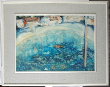
Painting, Summer Holiday, 1967
Aerial view of a harbour with a jetty and a boat. At edge of water is a narrow beach and 4 houses (white with roofs painted in orange, yellow, white and pale blue). Seaweed and reefs are visible below surface of water. Framed in wood and board frame (white and grey).Front: Barnard 1967 (lower left, blue paint). Back: Phyl Barnard "Summer Holiday" 1967. -
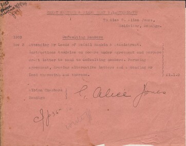 Bendigo Historical Society Inc.
Document - MISS G ALICE JONES COLLECTION: ACCOUNT
Great Eastern & Birds Reef N. L. Syndicate to Miss G. Alice Jones. Pink paper dated Nov 3 1933. Re Defaulting Members. Cost £1.1.0. "R693 delivered 3/7/34" written in the top left corner.miss g. alice jones - solicitor - account, great eastern & birds reef n l syndicte, mr leeds mccoll rankin & stanistreet -
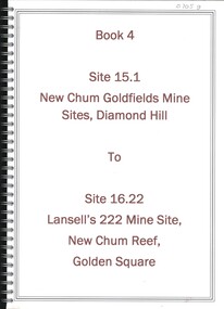 Bendigo Historical Society Inc.
Book - NEW CHUM GOLDFIELDS MINE SITE DIAMOND HILL TO LANSELL'S 222 MINE SITE NEW CHUM REEF GOLDEN SQUARE, 1992
Book 4, Site 15.1 New Chum Goldfields Mine site Diamond Hill to site 16.22, Lansell's 222 Mine site, New Chum Reef, Golden Square. Significance reports prepared for North Central Goldfields Project: Bendigo Goldfield.David Bannearbendigo, mining, goldfields report, bendigo, gold, goldfields, history -
Bendigo Historical Society Inc.
Document - NEW PRINCE OF WALES MINE - NOTES ON THE NEW PRINCE OF WALES MINE
Handwritten notes on the New Prince of Wales Mine on the Carshalton Line of Reef. Ground first worked in 1856. In 1859, the small claims amalgamated and 2 co-operative companies were formed, Hopkins & Co took the southern ground and Pegleg Co, the northern.Albert Richardsondocument, gold, new prince of wales mine, new prince of wales mine, notes on the new prince of wales mine, hopkins & co, pegleg & co, a m s page 59 -
Bendigo Historical Society Inc.
Document - CENTRAL RED, WHITE AND BLUE MINE - LOCALITY AND DESCRIPTION OF THE CENTRAL RED, WHITE AND BLUE MINE
Hand written notes on the Central Red, White and Blue Mine. Notes include depth of Shaft, when formed, locality, plant, poppet legs, engine house, crushing battery, gold produced and the reef the gold was obtained from. Also includes references.mine, gold, central red, white and blue mine, central red, white and blue mine, locality and description of the central red. white and blue mine, sheepshead line of reef, new chum hill, delbridge or mannings shaft, mine's dep't booklet 'bendigo goldfield' geo brown 1936, annals of bendigo1910 to 1936, a richardson -
Bendigo Historical Society Inc.
Document - NEW CHUM SYNCLINE MINE - NOTES ON THE NEW CHUM SYNCLINE MINE
Typed copy of notes on the New Chum Syncline Mine on the Nell Gwynne Line of Reef. Notes include depth of shaft, years of working, size of lease, locality, plant, best gold and total gold yield. Small locality map attaqched to front.document, gold, new chum syncline mine, new chum syncline mine, notes on the new chum syncline mine, walker & coy bundaberg, cameron & sutherland, little 180, central deborah, mines department booklet 'bendigo goldfield' 1936, mines dept annual and quarterly reports, a richardson -
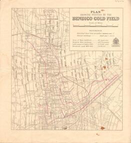 Bendigo Historical Society Inc.
Map - BENDIGO GOLD FIELD - MAP OF PORTION OF THE BENDIGO GOLD FIELD
Map showing portion of the Bendigo Gold Field showing Alluvial working, shaft sites , streets and lines of reefs.Department of Mines, Victoria. Many mines, lines of reefs and gullies are on the map. Blue Royal Historical Society of Victoria Bendigo Branch stamp on the back.document, bendigo gold field, department of mines, lines of reefs, gullies, mines -
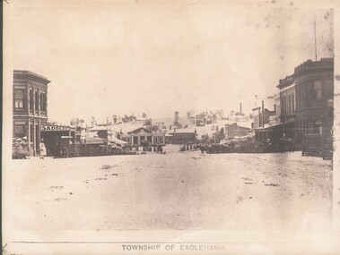 Bendigo Historical Society Inc.
Photograph - WES HARRY COLLECTION: TOWNSHIP OF EAGLEHAWK, C. 1860's
Sepia photograph of the Township of Eaglehawk, looking down the hill from about Victoria St. Visible are the Victoria Hotel and the Exchange Hotel on the left hand side of the photo. At the bottom of the hill there is the old Town Hall and in the distance on the hill is one of the Virginia Reef mines.place, eaglehawk, streetscape, eaglehawk, victoria hotel, exchange hotel, virginia reef -
Bendigo Historical Society Inc.
Document - PADDY'S GULLY LINE - NORTH VIRGINIA MINE
Two handwritten notes on the North Virginia Mine on the Paddy's Gully Line of Reef. Shaft No 286. Mentioned are: depth of shaft, production, Calls and Sill of shaft. Commenced operations in Sept 1933, ceased in 1942, recommenced in 1946 and ceased on 5/8/1949.document, gold, paddy's gully line, paddy's gully line, north virginia mine, m d -
 Bendigo Historical Society Inc.
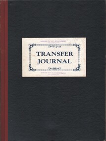
Document - MCCOLL, RANKIN AND STANISTREET COLLECTION: NAPOLEON REEF GOLD MINING CO. N.L, 1940-1941
Document: Napoleon Reef Gold Mining Company Transfer Journal, pre printed pages with hand written entries showing transfer of shares from one shareholder to another 5 June 1940 to 22 January 1941 (only 8 pages used).organization, business, industrial - mining, mccoll rankin & stanistreet, mining, gold mining, napoleon reef -
Stawell Historical Society Inc
Photograph, Water storage tanks part of reservoir in reefs road -- Coloured
Coloured Photo showing two water storage tanks part of reservoir in reefs roadDirt road in foreground power pole and water tanks. stawell -
 Otway Districts Historical Society
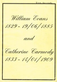
Book - Family History, Doris Robbins, William Evans 1929-19/06/1885 and Catherine Carmody 1833-14/01/1909, 1998
William Evans, being born in Anglesea, Wales, in 1829, migrated to Australia in 1857. He was appointed Assistant Lighthouse Keeper at Cape Otway Lighthouse in 1858, and married Catherine Carmody on the 14 May,1860. William and Catherine spent 22 years at Cape Otway. From this union, until August 1998, eight generations of children were recorded. The book explores the lives of these children.William Evans (1829-19 Jun 1885) and Catherine Carmody (1833- 14 Jan 1909), Doris Robbins. Self published; Colac (Vic); c.1998. 238 p.; illus, maps. Soft cover.william evans, catherine carmody, cape otway, lighthouse -
 Stawell Historical Society Inc
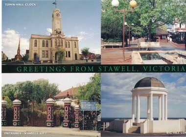
Postcard, postcard with 4 views of stawell
Town Hall Stawell, Gold Reef Mall, Central Park Gates, Big Hill MemorialPostcard showing four views of StawellStawellstawell -
 Torquay and District Historical Society
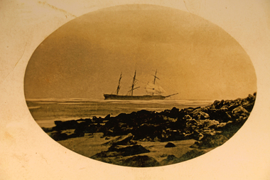
Photograph - Photograph (copy), Scammel Collection
Photo shows the Joseph H Scammel stranded on the reef off Point Danger Torquay in 1891One of the many ships wrecked on the coast of southern Victoria.Sepia photographshipwrecks great ocean road victoria -
 Ballarat Heritage Services
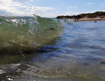
Photograph - Digital photographs, L.J. Gervasoni, Wavelet at Killarney Beach, 2016, c2016
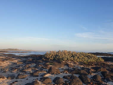
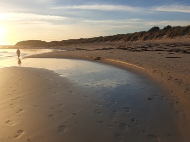
Killarney Beach is located at the end of Mahoney's Road. It is sheltered from wave action by offshore reefs. Colour photograph of a wavelet at Killarney Beach.beach, wave, killarney, killarney beach, killarney, victoria, coast, ocean, seascape, landscape -
 Ballarat Heritage Services
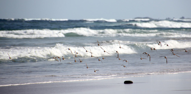
Photograph - Digital photographs, L.J. Gervasoni, Hooded Plovers Flying, Killarney Beach, 2015, c2015
Killarney Beach is located at the end of Mahoney's Road. It is sheltered from wave action by offshore reefs. Colour photograph of Hooded Plovers flying at Killarney Beach, Victoria. killarney beach, killarney, beach, coast, ocean, hooded plovers, birds, flying, seascape -
 Ballarat Heritage Services
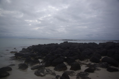
Photograph - Photograph - Colour, Clare Gervasoni, Killarney Beach, New Year's Eve, 2016, 31/12/2016
Killarney Beach is located at the end of Mahoney's Road. It is sheltered from wave action by offshore reefs. A number of beach scenes at dusk showing Killarney Beach. killarney beach, seaside, new year's eve, beach -
 Ballarat Heritage Services
Photograph - Photograph - Colour, Killarney Beach, 2016, 24/12/2016
Killarney Beach is located at the end of Mahoney's Road. It is sheltered from wave action by offshore reefs. Colour photograph of Killarney Beachkillarney beach, seaside, coastal -
 Ballarat Heritage Services
Photograph - Photograph - Colour, Clare Gervasoni, Killarney Beach, Victoria, 26/12/2019
Killarney Beach is located at the end of Mahoney's Road. It is sheltered from wave action by offshore reefs. Colour photograph of Killarney Beach, Victoria.killarney beach, coast, beach -
 Ballarat Heritage Services
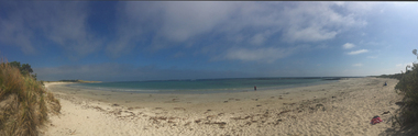
Photograph - Photograph - Colour, Clare Gervasoni, Killarney Beach, Victoria, 26/12/2019
Killarney Beach is located at the end of Mahoney's Road. It is sheltered from wave action by offshore reefs. Panoramic photograph of Killarney Beach, Victoria.killarney beach, coast, beach -
 Ballarat Heritage Services
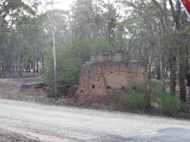
Photograph - Photograph - Colour, Steele's Pioneer Mine Ruins, Yandoit, 2016, 18/01/2016
Steele's Reef was opened in 1859 along with a number of other reefs in the Yandoit area. The reef was worked by small mining parties until the late 1880s. In 1887, the Steele's Reef Quartz Mining Company fixed steam pumping machinery and commenced sinking a shaft. The company were unable to find a profitable ore body and after two years work closed down. By this time their shaft had reached a depth of 150 feet. The mine was then taken over by the Pioneer Quartz Mining Company who appear not to have worked the mine. In 1906, the Steele's Pioneer Company commenced work, erecting a winding winch at the old shaft sunk by the Steele's Company. The next year the company erected a 10-head battery, set of poppet legs, a pumping engine. Sinking the shaft a further 100 feet, the company struggled to find payable ore and soon closed down.Colour photographs of the remnants of Steele's mine at Yandoit, Victoria. steele's mine, yandoit, mining, ruins -
Tarnagulla History Archive
Article: Old Tarnagulla, The Romance of Poverty Reef
Donald Clark Collection.A typed article with title 'Old Tarnagulla, The Romance of Poverty Reef'. Discusses a Minute Book of the Sandy Creek Progress Committee which was held (at the time of writing) by a member of the Old Tarnagulla-ites based in Melbourne. Written by C.P. Ward, date unknown, probably 1970s. -
 Bendigo Historical Society Inc.
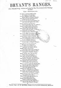
Document - AUSTIN COLLECTION: 'BRYANT'S RANGES' WORDS OF SONG
Copy of song written by Charles Thatcher, 'Bryant's Ranges' 'New original song, written and sung by Mr Thatcher at the Bendigo Theatre, tune Bow-wow-wow. Song mentions Bendigo reefs and the gold seekers success or otherwise, then they were off to 'Bryant's Ranges'.bendigo, mining, song by charles thatcher -
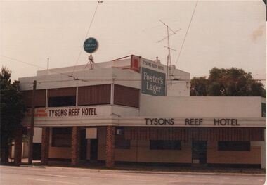 Bendigo Historical Society Inc.
Photograph - BENDIGO HOTEL COLLECTION: TYSONS REEF HOTEL, WEEROONA AVENUE, BENDIGO
Colour photograph: Two storey building, with single storey section on RH side, plain façade, white painted, unpainted brick verandah supports to edge of footpath. Tysons Reef Hotel in brown paint in two places on front of building. Early 1980's ?bendigo, hotel, tysons reef