Showing 1016 items matching "paddock"
-
 Ballarat Tramway Museum
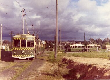
Photograph - Colour Photograph/s, B. Groves?, 7/12/1962 12:00:00 AM
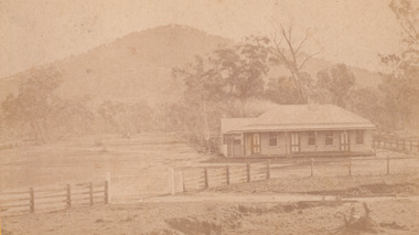
Colour print of five SECV Bendigo trams at the North Bendigo tram terminus during a 1962 tour. Tram 28 (Birney), another Birney and then three single truckers at the terminus. All have their poles turned to return to the City. Photo shows the nature of the location of the terminus; open paddocks. All trams have been fitted with dash canopy lights. Taken on AGFA paper. On rear is a stamped date "- 7.12.62", looks like a machine imprint.On rear "Tram Tour Bendigo / Mr. B. Groves / 333 Pascoe Vale Road / Essendon W5 / Vict." In top right hand corner is the number "1175" In the stamp appears " 110B / Photo / The? / -7.12.62"birney, bendigo, north bendigo, tram 28 -
 Bendigo Historical Society Inc.
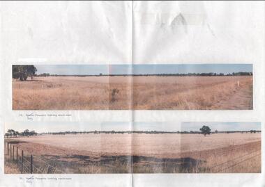
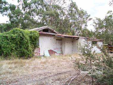
Photograph - Kangaroo Flat Gold Mine Collection: photos of Woodvale site, Daly property, pre dam construction, 1986
Photographs taken at the time of the purchase by Western Mining Corporation of the property owned by G.P. Daly of Raywood Road, Woodvale, in 1986. The intent of the purchase was to provide land for the Woodvale ponds. Land size was 16 acres, known as Allotment 13, Section 3, Parish of Nerring. Paper with two colour photographs attached, each of three photos joined to show landscape view, of the property purchased from G.P Daly by Western Mining Corporation. Photographs show rural land, grassy paddocks with tree line in background. Barb wire fence visible in foreground of bottom photo. Top photograph is titled 23. Daly property looking south-east. Bottom photograph is titled 24. Daly property looking north east. woodvale, g.p. daly, western mining corporation, purchase -
 Benalla Art Gallery
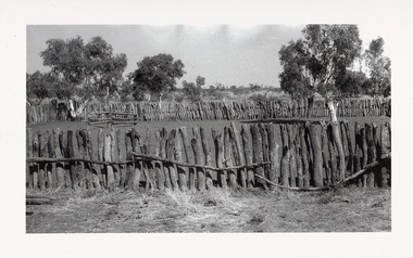
Photograph, Sidney NOLAN, ‘Central Australia’ series, 1949
Born: Carlton, Victoria, Australia 1917; Lived and worked: England 1953-1992; Died: London, Middlesex, England 1992Post WarGift of the Friends of the Benalla Art Gallery, 2005 Black and white photogaph of makeshift horse arena. Unframed in archival folder.Recto: Not signed, not dated, not titledphotograph, fence, hill, rural, arid, tree, building, figures, fence, bush, child, woman, rock painting, paddock -
 Ballarat Heritage Services
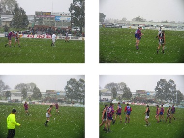
Digital photographs, L.J. Gervasoni, 2004 CHFL grand final in the snow, 2004
Australian Rules grand final played in the snow at Ballaratvictoria, weather, paddock, australian, australian rules, football, aussie rules, grand final, match, hepburn fnc, hepburn, burras, snow, playing -
 Eltham District Historical Society Inc
Photograph, Richard Pinn, Wattle Glen Picnic Ground, Dilapidated Pavilion Building, 2015, 07/02/2015
The Wattle Glen Picnic Ground was located in a paddock just west of the Wattle Glen railway station (between the station and the creek). It has now completely disappeared except for a dilapidated overgrown building on a rise across the track from the railway platform. This was the picnic ground's main pavilion, which for a short time (circa 1972-1974) also served as the Wattle Glen post office and general store. The picnic ground operated from circa 1925 until late 1974, its heyday being in the early 1970s.Born digital (three images)wattle glen, picnic ground -
 Federation University Historical Collection
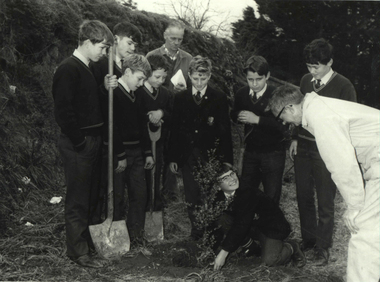
Photograph - Photograph - Black and White, Ballarat Technical School Students Plant Out Old Gaol Terraces, 1969, 14/07/1969
When Ballarat Junior Technical School's new building was opened in 1921, the surrounding area was rubble-strewn with raw clay slopes. The Head, A W Steane designed the landscaping of the slopes from the Gaol wall down to the Battery Paddock. The boys did much of the work. Apart from beautifying the grounds, this project occupied their leisure time, particularly as they had nowhere to play. The school acquired the gaol site in April 1969. The work of improving the grounds which was begun by A W Steane and his students is being carried on.Eight Form 1 boys from Ballarat Technical School planting trees at the old Ballarat Gaol terraces. Don Ogilvie is in the foreground. Peter Murley is planting watched by Frank McKenzie in the background. Boys from left: John Brown, Bradley Julius, Gary Green, Steven Ryan, Kim Hall, Peter Gross, Peter Rasmussen.Details of photograph written in pencil on back "Ballarat Courier Press Photograph - Copyright - " stamped on back.ballarat junior technical school, grant street garden, garden terrace, ballarat gaol, battery paddock, former ballarat gaol walls, don ogilvie, john brown, bradley julius, gary green, steven ryan, kim hall, peter gross, peter rasmussen., peter murley, frank mckenzie, ballarat technical school -
 St Kilda Historical Society
Photograph
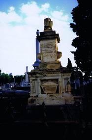
The Melbourne General Cemetery opened in June 1853. The first male buried there was John Alexander Burnett, chief clerk to the mercantile firm of Dalgety, Borradale & Co. The headstone reads: In Memory of James Alexander Burnett, Merchant, Who Died 25 May 1853, Aged 36 Years. Burnett Street, St Kilda, is named after him. The street was created by F. G. Dalgety when he sold his land in St Kilda (12 acres known as 'Dalgety's Paddock') on 12 April 1853.Colour photographIst Grave in Melbourne Cemetery of St Kilda identity John Alexander Burnettst kilda, john alexander burnett, melbourne cemetery -
 City of Greater Bendigo - Civic Collection
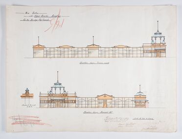
Work on paper - Architectural Drawing, City of Bendigo, New Baths at Upper Reserve Bendigo for the Bendigo City Council, 18th November 1912
The 'New' City of Bendigo baths also known as 'The Baths' were opened on 26th February,1913 at a cost of £2000. These baths made use of an existing dam and had men only and ladies bathing areas as well as a 'paddling paddock' for young children. This set of plans is for the Men's Bathing shed which serviced the men's bathing area adjacent to the still existing tennis courts on Barnard Street. In 1958 the Municipal Baths were replaced by an Olympic Pool and £17,000 was raised by public subscription towards this pool’s construction. Ink, pen, pencil and watercolour architectural drawing for the proposed new baths at the Upper Reserve on Barnard Street, Bendigo.New baths / at Upper Reserve Bendigo / for the Bendigo City Council / Elevation facing tennis courts / Elevation of Terminals at A, A, / Elevation facing Barnard Street / This is one of the drawings /referred to in my contract/ dated 18th November 1912 / Signed Robert J Rogers / (unknown) / Mayor Jas Semmensbendigo swimming club, rosalind park, upper reserve bendigo, faith leech memorial swimming pool, bendigo baths, city of greater bendigo community groups -
 City of Kingston
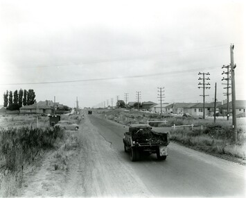
Photograph - Black and white, 27 February 1964
Cheltenham is a suburb in the City of Kingston that was originally established as a rural market gardening community. The area is bordered by Highett. The previous market gardens, farms and paddocks have gradually been sub-divided into housing and industrial estates. The Methodist Children's Home Methodist Homes for Children and St John of God Training Centre on the site of the future Southland shopping centre has not yet been demolished. The recently built Cheltenham High School is visible and the increased urbansation of the area is evident. Some farmland remains including the Le Page homestead.The developing urban area of Cheltenham within the City of Kingston. This image illustrates the mid-century urban sprawl of of Cheltenham and the subdivision of market gardens within the municipality and the changing demographic of the district as new houses are constructed and infrastructure established.Aerial photograph of the suburbs of Cheltenham and Highett within the City of Kingston. Highett Gas Works (top left); Bernard Street, Cheltenham (top right); Weatherall Road (bottom left): Elliott and Cobham Streets Cheltenham (bottom right).White handwritten: X Vic.1831 White type: MELBOURNE 1963 PROJECT RUN23 [underlined] 27-2-64 LENS 205 152-70 M/M 5.150 [arrow] White handwritten: X 166 cheltenham, highett, urbanisation -
 The Beechworth Burke Museum
Photograph - Carte de Visite, William E Barnes
In July of 1880, Ann Jones' successful hotel in Glenrowan burnt to the ground during the Kelly siege. She had opened her business in the year prior having been unsuccessful in her attempt to run a tea-room business in Wangaratta. The first building on this particular site was the home Ann Jones had built for herself and her family. Two years later she converted the home and added the hotel to the rear of the structure. One year later it was burnt to the ground. This image depicts the streetscape of Glenrowan in 1883, three years after the siege. Importantly, it reveals the appearance of several buildings which can reveal information for how Glenrowan (as a small town) might have stood during the siege. These buildings are of typical Australian colonial "miner's cottage" style. On what would have been the site of Ann Jones' hotel, to the far left of the photograph, a police station stands. This police station was built before April 1883. This Carte-de-viste (CdV) taken by renowned Wangaratta based photographer William Edward Barnes previously belonged to the donor's grandfather, Daniel Mullins who was a Police Officer stationed at Glenrowan soon after the Kelly gang siege. Today, the siege has become an important part of Australian culture and Ned Kelly and the Kelly Gang (comprising of Ned Kelly, Dan Kelly, Steve Hart and Joe Byrne) has become ingrained in Australian history and mythology. A CdV is a sepia toned photograph mounted on card and is generally of a small size. This particular style was first patented by Andre Adolphe Eugene Disdéri (1819-1889) in 1854. In 1857, the CdV was introduced to England and after photographs of Queen Victoria, Prince Albert and their family were taken using CdV in 1860 the popularity of this method reached a peak.This photograph is part of the Burke Museum "Kelly album" which includes a significant collection of photographs and artefacts connected to Ned Kelly and the Kelly Gang. Ned Kelly and his gang have become ingrained in Australian popular culture and thus many museums, art galleries and private collections house material connected to the Kelly story which allows the events and people to be researched and interpreted. Artefacts and photographs pertaining to the Kelly gang are particularly valuable for Australian museums. This particular photograph is significant for its connection to Wangaratta based photographer William Edward Barnes and to the Glenrowan Siege and Ann Jones' Hotel which burnt down during the siege in June 1880. Taken in 1883, this photograph has the opportunity to provide information about the townscape of Glenrowan shortly after the siege. It also provides important insight into the architecture and layout of the town. To the far right of the image, the photograph depicts the police station which was built on the site of Ann Jones' Hotel which can provide important information for the Kelly story and how the town evolved following 1880. It is also interesting to emphasise that the police station was built on the site of Ned Kelly and the Kelly gang's last stand.This photograph is a sepia image mounted on yellow card which depicts the newly built police station (in 1882) which stands on the far right of the image on the site of the former Ann Jones Hotel. A fence appears through the lower front of the image and an open paddock is to the left. In the rear centre of the image, there is a mountain. In front of the mountain are many trees, most of them gum. The police station is a one storey structure with a veranda and there are three doorways visible in the image. The image depicts four windows on the front of the station.W.E.Barnes / photographer / Wangaratta / ...1882 / BMM8087kelly album, william barnes, wangaratta photographer, carte-de-viste, glenrowan, 1882, police station, ann jones inn, ann jones hotel, kelly siege, glenrowan siege, colonial australia -
Tatura Irrigation & Wartime Camps Museum
Certificate of Title, Subdivisions, 1879 and 1930
Title Deeds for property in Tatura2 certificates of title showing subdivisions made over several years. Vol. 5655:Folio 1130935 dated 16/5/1930 and Vol.1182: Folio 236330 dated 23/12/1869. Lease between Thomas Hogan and W F Bazeley dated 7th July 1911 for land in Hogan Street known as Slaughter Yard Paddock .Also lease dated 1911. In buff coloured legal envelope with number "2678" and "Hogan - Thomas" written in red on outside.tatura, relationship folders, certificate of title, lease, thomas hogan, john hogan, john james hanlon, edward glover, arthur burke, james brady, andrew collie, jean hunter, sydney embling, john maher, arthur goyen, patrick o'toole, philipe dove, george wildon, edwin harden, cuthbert corke, lee chung, hugh barnes, george manning, francis williams, john fawkner, michael walshe, alexander ferguson, rose gullett, john gibb, william taylor, richard casey, anthony grover, arthur grover, charles brady, elizabeth davey, frank williams, honora culkin, alexander park, stephen reville, richard carr, charles grover, henry mccarthy, james bruce, edward hanley, chew yen, ah poy, loo way, ah dick, charles mitchell, lionel martin, douglas forsyth, catherine wilson, mabel heath, patrick mcnamara, micheal cussen, james wilson, bazeley, documents, legal -
 University of Melbourne, Burnley Campus Archives
Photograph - Colour print, A.P. Winzenried, Down on the Farm-at Burnley, 1931-1990
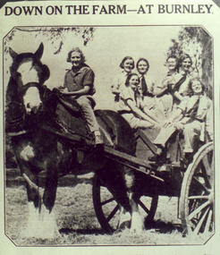
Photograph made by A.P. Winzenried for, "Green Grows Our Garden," p73Colour photograph. Copy of newspaper article, made by A.P. Winzenried. Caption reads, "Down on the Farm-at Burnley. New recruits at Burnley Horticultural School drove in rustic state to gather the maize crop yesterday. So popular has the school course become that there are no more vacancies for students this season. These beginners tackled a tall job, for the maize produced in the school paddock is 10 to 11 feet high." Horse drawn cart with 6 female students seated on it and one astride the horse.a.p. winzenried, green grows our gardern, maize crop, students, students working outside, west orchard, horse-drawn cart, draught horse -
 Surrey Hills Historical Society Collection
Photograph, Grovedale Road Quarry in the 1920s - looking north, c1920
The quarry was part of John Butler Maling's property. He was one of the original settlers of the area and farmed the area between Weybridge Street and Whitehorse Road. Clay was quarried from part of this area and used to make the bricks used in the construction of his home, known as 'Ancyra'. This is still extant at the corner of Weybridge and James Streets. Maling grazed cows and used the quarry as a water source. He was the uncle of John Butler Maling, Mayor of Camberwell. He was married to Kate Conlon in 1882. They had 3 children: Silas Young, Alick and Zillah. Maling was born in c1829 in Shepreth, Cambridgeshire; he died in Surrey Hills on 9 October 1912 and is buried in Box Hill Cemetery - CE-*-0586. Mrs Kate Maling (born c1859 in Co Meath, Ireland) died at the property on 8 March 1921. She is buried in Brighton General Cemetery. Probate was valued at over 10,000 pounds and included other properties in Sandringham, Hawthorn and Macedon. At the time of her death the Surrey Hills property was described as being 23 cres with 2 brick houses, 1 cow, 2 heifers and 40 fowls or chickens. The property was subdivided after her death. The quarry was filled in after several drownings or near drownings and the land is now occupied by a park and playground maintained by the City of Boroondara. Beckett Park is sited on horizon to the left beyond the trees. This documents the landscape prior to close settlement and is material to early building and farming in the Surrey Hills area.Black and white photo of the quarry between Grovedale Road and James Street taken in the 1920s and looking north. In the foreground is an area of water with high banks dividing the horizontal centre. Beyond are paddocks and trees behind which is a row of at least 3 single-storey houses. Light poles can be seen along a distant street. There are many mature trees in the background. The houses and trees are positioned along Whitehorse Road in the vicinity of Westminster Street. Shadows indicate the photo was taken in early morning or evening.quarries, grovedale road, james street, surrey hills, balwyn, clay quarries, ancyra, kate conlon, kate maling, john butler maling, farming -
 University of Melbourne, Burnley Campus Archives
Album - 35mm Colour slides, Garden Views and Miscellaneous, 1960-1964
18 slides 1960-1964. 1. "Pep Talk" Feb 1960 (Wilson's Promontory?) 2. "Undeveloped land (mowed) Ryde S of H 17.3.61". 3. "Burnley Hort College Feb 1962". 4. "BHC Vege Ground 1963", 5. "Cow Paddock New Plantings. 4, 6, 15, 16, 19. Orchard 1963". 3, 7-11, 13, 14. Garden views Sep 63. 17, 18. "Second Year Students 1964-Mildura".burnley horticultural college, cow paddock, plantings, garden views, students, bhc, lagoon paddock, vegetable plots, mildura camp, orchard, wilson's promontory -
 Linton and District Historical Society Inc
Photograph, Kitty Jennings and Joyce Chung
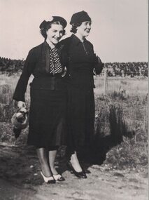
Kitty (Catherine) Sandow and Joyce Rowe grew up in Linton and attended Linton State School. Kitty Sandow (1916-1984) married Reg Jennings in 1946. Joyce Rowe (1912-1997) married Mick (Martin) Chung in 1931. Kitty and Reg took over the management of Kitty's parent's grocery and confectionery shop, which then became known as "Jennings' Milk Bar". Joyce, a descendant of the Nicol family, worked at Nicol's bakery. Her husband Mick Chung worked for the railways.Enlarged black and white copy of original photograph which has been mounted on card. The photograph shows two women, both wearing dark coloured jackets and skirts, hats and dress-shoes. The woman on the left is carrying a handbag, while the woman on the right has a handbag tucked under her arm. They are standing on a roadway or track, and a wire fence and paddock can be seen in the background. Kitty Jennings (née Sandow) and her friend Joyce Chung (née Rowe). The photograph is undated.joyce chung (née rowe), kitty jennings (née sandow) -
 Dandenong & District Historical Society
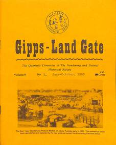
Journal, Dandenong & District Historical Society, Gipps-Land Gate Vol.8 No.3, 1980
An interesting group of Early Dandenong Personalities, Places and EventsA5 size publication of the Gipps-Land Gate, June - October 1980, 16 pages, featuring an old picture of Dandenong on the cover. Keeping Posted Projects Suggested For Victoria's Sesqui-Centenary History Of Clayton When The Natives Still Roamed This District Harking Back 75 Years Ago Personalities Behind The Headstones Alex T. McLean Snr Constable Fitzgerald Was Police Paddock Identity Little Snippets From Our Past George Howard - Pioneering Personality An interesting group of Early Dandenong Personalities, Places and Eventshotel history, early education in dandenong, interesting milestones, family histories -
 Eltham District Historical Society Inc
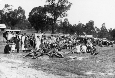
Photograph, Returned soldiers picnic, Police Paddocks, Queenstown, c.1916, c.1916
Possibly a picnic for returned servicemen from Gallipoli. This photo was taken in front of the Police Paddocks with the police station on the left. Model T Fords parked with soldiers, drivers and locals resting on the police paddock in front of the Queenstown (St Andrews) station. The RACV Volunteer Motor Corps service during World War One was the reason the organisation was granted its Royal prefix. Automobile Club of Victoria members volunteered their time and vehicles to collect returning soldiers and nurses from ships at Princes Pier, Port Melbourne. Trips were also often arranged for convalescing soldiers to country areas for picnics and to “revive spirits”. The soldiers were also picked up from the Austin Hospital in Heidelberg and Mont Park Military Hospital in Macleod. Queenstown (St Andrews) was a common picnic spot. The Evelyn Observer reported on June 9. 1916 "Some 75 returned soldiers visited Queenstown on Sunday, 28th ult., and were hospitably entertained by local residents who had provided refreshments sufficient for 150. Mr. Milne in an appropriate speech welcomed the soldiers, and Mr. Robison suitably responded.” The photo was reproduced page 108 of “The Diamond Valley Story" by Diane H. Edwards.This photo forms part of a collection of photographs gathered by the Shire of Eltham for their centenary project book,"Pioneers and Painters: 100 years of the Shire of Eltham" by Alan Marshall (1971). The collection of over 500 images is held in partnership between Eltham District Historical Society and Yarra Plenty Regional Library (Eltham Library) and is now formally known as the 'The Shire of Eltham Pioneers Photograph Collection.' It is significant in being the first community sourced collection representing the places and people of the Shire's first one hundred years.Digital image, 16 x 24 and 12.5 x 9 cm and 4 x 5 inch B&W Neg sepp, shire of eltham pioneers photograph collection, queenstown, cars, police station, st andrews, soldiers, picnic, exhibition yprl 2019-12, gallipoli, model t ford, pioneers and painters, police paddocks, retuned soldiers -
 Eltham District Historical Society Inc
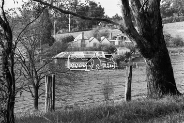
Photograph, George Coop, Carrucan's Dairy on Dalton Street, Eltham, c.1969, 1969
Viewed from intersection of Mount Pleasant Road and Metery Road looking northwest. The dairy is in the foreground situated on Dalton Street. An unmade Bible Street can be seen running down the hill at the left to intersect with Dalton Street. Dalton Street runs from left to right between the dairy and the Carrucan family home opposite located on the southeast corner of Bible and Dalton streets. Doug Orford recalls the dairy was at a slight angle to Dalton Street. Tim Erickson, (a nephew to Betty Erickson, nee Carrucan) reacalled (9 May 2025): the bottom front paddock ran from MeteryRoad to Mount Pleasant Road The brick dairy from 1thje 1950s had 10-15 milking cow , Jersey and Guernsey6 and the used to send the cream to Eltham Dairy The garage when Tim was a child used to house a couple of sulkies The laundry was a local home built job The small house built late 1940s for Betty Carrucan for her family The small orchard grew Quince, Apple and Plum The main block was the upper paddock Cypress trees remain present as of 2025 Originally 2 buildings but a third was added in the early 1900s for a kitchen and diningDigital TIFF file Scan of 35mm Ilford HP4 black and white transparencybible street, carrucan dairy, carrucan home, dalton street, eltham, mount pleasant road -
 Kiewa Valley Historical Society
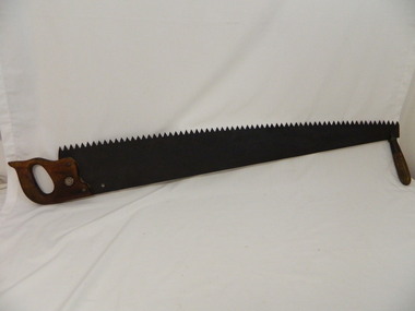
Saw Logging, circa early 1900's
This item can be seen as a hand piece belonging to a logger or farmer spanning over one hundred or more years. The equipment was made to perfection as a hand tool and has not been improved upon since its introduction into the logging industry or farming fraternity. It can be used by one person or two (husband and wife or father and child). Its versatility is ageless. It can be used for domestic clearing of the paddocks, or for domestic fire places and stoves or commercial logging up until the 2000s (introduction of specific logging trucks that cut and treat the trees in one process).This item is very significant to the rural and logging regions within the Kiewa Valley. It has been used for domestic wood cutting and for industrial logging in the mid to late 1900s. It was used when clearing land for the SEC Hydro scheme and to allow for the introduction of the Mount Beauty construction workers' village (later developed into the town) The great advantage of this saw was that it uses only muscle power and can be located where ever a lumber "Jack" or property owner can venture. either by foot or by horse.This saw is a Warranted Superior One/Two Man Logging Saw. It has 68 teeth and is 42 inches long. At a position of one inch (2.5cm) from the end is a hole one inch down from the leading edge. There is another hole 45 cm in front of the handle. Both these holes are for a "helper handle" which when in use renders this logging saw fit for a two man operation. This is a cross cut saw for cutting down vertical trees (horizontal cut) The handle is made from wood and fastened to the blade by three heavy duty screws. The one helper handle stands 150mm high and has a 150mm wooden hand grip.The central screw has 25mm manufacturers' identification logo stamped "WARRANTED SUPERIOR".one or two man cross cut saws, forestry, timber industry -
 Tatura Irrigation & Wartime Camps Museum
Photograph, Coursing and Racing Club
Greyhound Coursing was popular as far back as 1886, when the first president of the club was Mr Gellion. From 1896, open coursing was held at Dhurringile Estate until 1904, when meetings were held "in the paddock north of the town" In 1919 the Tatura Plumpton Coursing Club was inaugurated and successfully ran many of the classics, such as the Oaks, Derby, and Waterloo Cup meetings until 1967, when Plumpton Coursing was declared illegal. Plumpton Coursing Club: L-R: Neil Colliver, Mick O'Reilly, Jack Maher, John Marker, Tom Cornish.Black and white photograph of members of the Plumpton Coursing Club. Photograph on foam backing.Plumpton Coursing Club - list of members (see below). approximately 1950's.tatura, recreations, sports -
 Stawell Historical Society Inc
Photograph, "Ashen" Homestead Remnants in Murtoa after a Storm c1920’s
Dugald McPherson's Ashen's Homestead (Remnants) c1920’s Ashen's south of Murtoa was one of the area's original squatting runs. This photo taken in the 1920's shows the homestead after a violent storm had been through the area. In 1853, the country around Ashen's was covered by timber, she-oaks, bull-oaks, light gum and box thickets of ti-tree and clumps of pine and wattles. The vegetation was so thick outside the horse paddock it was difficult to move in any direction. It was said McPherson and two others fought over the land.Back entrance to Ashen's Station.stawell -
 Surrey Hills Historical Society Collection
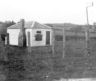
Photograph, The gate-keeper's shed, Surrey Hills Golf Club
Reproduced by permission of Mr John Arnold from his book: "The Riversdale Golf Club - a history, 1892-1977." Copyright to book: Riversdale Golf Club. Surrey Hills Golf Club operated from 1892-1908 then moved and became Riversdale Golf Club. The game was played across paddocks from Trafalgar Street, Mont Albert to Whitehorse Road and down Victoria Crescent to where Box Hill TAFE is now located in Elgar Road. There were problems with cows eating the tee flags! The clubhouse still exists as 30 Trafalgar Street.Apart from it association with the Surrey Hills Golf Club which is long gone, this image documents the landscape of pre-urban Surrey Hills.Black and white photo of a rectangular timber building with a slate hip roof and brick chimney on the LHS. The one visible window appears to be boarded up and has a door to its right. The building is fenced by posts and wire. A (?) street sign bearing the letters FLINT is at the right of the picture."The gate-keeper's shed was used as a clubhouse from 1895-1900."sports grounds, surrey hills golf club, riversdale golf club, timber building, john arnold -
 Surrey Hills Historical Society Collection
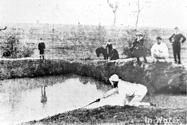
Photograph, Surrey Hills Golf Club water hazard, 1895, 1895
Reproduced by permission of Mr John Arnold from his book: "The Riversdale Golf Club - a history, 1892-1977." Copyright to book: Riversdale Golf Club. Surrey Hills Golf Club operated from 1892-1908 then moved and became Riversdale Golf Club. The game was played across paddocks from Trafalgar Street, Mont Albert to Whitehorse Road and down Victoria Crescent to where Box Hill TAFE is now located in Elgar Road. There were problems with cows eating the tee flags! The clubhouse still exists as 30 Trafalgar Street.Apart from its association in documenting the Surrey Hills Golf Club which has long disappeared, this image documents the landscape in the pre-urban era.Black and white photo of a scene at Surrey Hills Golf Club. There is a water hazard in the foreground with a lady on her knees trying to retrieve a ball from the water's edge. Three lads, one on a horse, are watching, as are 3 males to the right."In water" in the bottom right of the photo. Caption: "Captain Fred Andrew watches his partner's misfortunes during a game at Surrey Hills in 1895."sports grounds, surrey hills golf club, riversdale golf club -
 Surrey Hills Historical Society Collection
Photograph, Corner of Braemar and Melrose Streets, Box Hill North
Reproduced by permission of Mr John Arnold from his book: "The Riversdale Golf Club - a history, 1892-1977." Copyright to book: Riversdale Golf Club. Surrey Hills Golf Club operated from 1892-1908 then moved and became Riversdale Golf Club. The game was played across paddocks from Trafalgar Street, Mont Albert to Whitehorse Road and down Victoria Crescent to where Box Hill TAFE is now located in Elgar Road. There were problems with cows eating the tee flags! The clubhouse still exists as 30 Trafalgar Street.Black and white panoramic photo taken from the corner of Braemar and Melrose Streets, Box Hill North. There is a large area of ground in the front. A fence and hedge traverse the photo in the middle distance in front of which is a tall light pole. Behind the hedge mature trees and houses can be made out.Caption: "Bottom: The same view today taken from the corner of Braemar and Melrose Streets, Box Hill North, or, from the position of the threesome to the left in the above photograph." + in grey lead pencil in Jocelyn Hall's hand (No 290)sports grounds, surrey hills golf club, riversdale golf club, melrose street, braemar street, surrey hills, john arnold -
 Bacchus Marsh & District Historical Society
Map, Maddingley Township, Parish of Parwan, 1880s
This map is dated Sept. 6th 1856. However places in the township of Maddingley which did not appear until the late 1880s such as the Bacchus Marsh Railway Station and line are shown on this map in their correct locations. This suggests the map has been derived from an earlier map. An earlier date of 1843 with a surveyor's name preceding it can also be seen on the map. The map is important because it indicates the location and dimensions of early but now discontinued use of land such as the showgrounds and police paddock and a site reserved for the Church of England which was not ultimately used for a permanent church. A single page paper map showing land allotments, streets, rivers, creeks, park lands, the railway line and Bacchus Marsh railway station in the township of Maddingley. The map is pasted into a bound volume containing 76 maps or plans in total. Bottom of Map: Surveyor-General's Office, Melbourne, Sept 6th, 1856bacchus marsh victoria maps, maddingley victoria maps, land use, maddingley victoria history -
 Eltham District Historical Society Inc
Photograph, Trestle Bridge, Eltham, c.1910
Most likely an F-Class 2-4-0 Steam Locomotive pushing carriage about to cross the Eltham Railway Trestle Bridge heading towards Greensborough, viewed from what was later Eltham Common and site of the re-located Shillinglaw Cottage (1964) and Eltham Library (1994). On the far side of the track on what is present day Central Park oval is a crop field. The railway was commenced in 1900 and passed through the middle of the Shillinglaw Farm. Here it passes through the farm paddocks. The train station at Eltham opened in 1902. Colour photocopy of original photo print (on loan?) 25.5 x 39 cm mounted on coreflutePencil mark at bottom "(c) 1910"eltham, trestle bridge, bridges, shillinglaw farm, f-class 2-4-0 steam locomotive, eltham railway trestle bridge, eltham trestle bridge, railway bridge, steam locomotive -
 University of Melbourne, Burnley Campus Archives
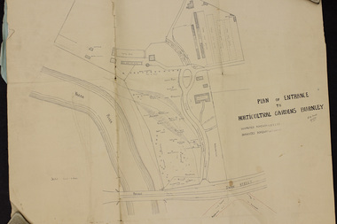
Plan, Plan of Entrance to Horticultural Gardens Burnley, 1932
Copy of plan photographed at the Public Records Office Victoria. (1) Hand drawn plan signed by A.W. Jessep 8/12/32 with 'Suspected Roadway' and ' Suggested Roadway'. Scale 1 inch - 1 chain. Trees on East side named. (2) Memorandum to The Agricultural Superintendent dated 08.12.1932 'Re Proposed Boulevard Along the River Yarra' from the Principal A.W. Jessep. Plan had been to put road through the Lagoon Paddock and he suggested the route outside the Burnley College grounds.prov, burnley gardens, a.w. jessep -
 University of Melbourne, Burnley Campus Archives
Album - 35mm Colour slides, Miscellaneous Burnley, 1985
1, 3-8, 15, 20, 22. Quad. Feb 85. 19. Pruning Day 1985 "Barry Dimelow" Jul 85. 18. Apprentice? mowing the Bull Paddock, 2, 11. Administration Building, 14. Nursery, Nov 85. 23, 24.News reporters Dec 85. 27-41. Possible excursion, using a cultivator, not Burnley Nov 85. 10, 13. Garden view. 16. Signing of documents by the Principal? 21. Possibly part of Old Nursery. 43. Sunken garden.pruning day, 1985, barry dimelow, bull paddock, administration building, mowing, publicity, cultivator, quad, nursery, excursion, apprentice, sunken garden -
 City of Kingston
Photograph - Black and white, c. 1957
This image shows the urbanisation of a formerly rural area of Moorabbin.Black and white photograph looking west along South Road. There is a truck in the foreground, travelling along the sealed South Road. A car is waiting to exit from Rowan Road. People are walking along the left hand side of the road, and a young person a bike is riding along the right side. They are all going in the same direction as the traffic. The left hand side of the image shows paddocks in the foreground, which houses further back. The right hand side of the image shows suburban houses with electricity poles running the length of the road. Handwritten in blue ink on reverse: 57-523A Handwritten in red ink on reverse: 85% Handwritten in black ink or grey lead: Ch. 6moorabbin, cars, roads, housing -
 Wodonga & District Historical Society Inc
Functional object - Chinese Ceramic Spoons
During the Victorian goldrushes of the 1850s thousands of Chinese migrants arrived to seek their fortunes. At that time many came to the lucrative gold fields of Northeast Victoria. After the Gold rush, many Chinese migrants returned home. However, a number settled in the area as merchants, hawkers and market gardeners in surrounding towns including Wodonga, the Ovens, King, Buffalo River and Kiewa Valleys. They also rented lands and established themselves in the hops and tobacco farming industries. These spoons were found by Mr Robert Black when he was ploughing a paddock on his farm in Kergunyah, Victoria in the 1930s.2 small ceramic Chinese spoons. Spoon 1 has a clear light green glaze. Spoon 2 is decorated with a blue painted pattern.chinese immigration to victoria, chinese market gardens, chinese migration northeast victoria