Showing 927 items matching "peak"
-
 The Beechworth Burke Museum
Photograph, c1960
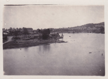
... The present day park and reserve occupies the site of the former Rocky Mountain Mining Company, an open-cut sluice mine that began operations in the mid-Nineteenth Century and operated until the early 1900s, through the peak of Victoria’s Gold Rush. It was converted into a park and leisure area in the 1920s. ...The present day park and reserve occupies the site of the former Rocky Mountain Mining Company, an open-cut sluice mine that began operations in the mid-Nineteenth Century and operated until the early 1900s, through the peak of Victoria’s Gold Rush. It was converted into a park and leisure area in the 1920s. ...The photograph depicts a view across the water at Lake Sambell. The image dates from approximately 1960. The present day park and reserve occupies the site of the former Rocky Mountain Mining Company, an open-cut sluice mine that began operations in the mid-Nineteenth Century and operated until the early 1900s, through the peak of Victoria’s Gold Rush. It was converted into a park and leisure area in the 1920s. Lake Sambell was formally opened to the public on Friday 5th October 1928 and was opened by the Victorian Government’s Minister of Lands, Mr Bailey, as part of initiatives to boost the economies and development of country towns. The lake was named after Mr L.H. Sambell, a shire engineer and secretary of the Forward Beechworth Committee who was involved in promoting the transformation of the mining site and promoting plantation forestry and tourism as alternative industries. £300 to begin the process was provided by Mr J. McConvill, a former resident of Beechworth, who is remembered in a street name adjacent to the lake. Residents of Beechworth have worked to raise funds to improve the Lake Sambell reserve several times, such as efforts in the 1930s and 1940s to raise the banks several feet to deepen the water for swimming purposes. Fundraising campaigns include the ‘Ugly Man’ competition conducted on behalf of the Wallace Park-Lake Sambell Development Scheme. The latter competition was run by the Fire Brigade Bend’s team as part of a larger competition called the ‘Mile of Pennies’; it was won by Mr Len Knight of Beechworth’s Commercial Hotel. The ‘Mile of Pennies’ was conducted at a Carnival held on New Year’s Eve, 1947. It was proposed by the Beechworth and District Progress Association. As well as improving swimming facilities, funds were raised to install a caravan park facility near the lake. Funds were also donated by commercial entities, such as £250 received from Zwar Bros. Pty Ltd. The photograph is significant as it shows the level of development of Beechworth in the early to mid-Twentieth Century. Sepia rectangular photograph printed on matte photographic paperObverse: nil. Reverse: 3470 / Velox (paper mark)beechworth, beechworth lake, lake sambell, lake, beechworth and district progress association, forward beechworth committee, ugly man, mile of pennies, wallace park lake sambell development scheme, wallace park-lake sambell development scheme, zwar bros, zwar, l.h. sambell, j. mcconvill, minister of lands, commercial hotel, len knight, rocky mountain mining company, rocky mountain mining co, gold rush, redevelopment, transformation, community fundraising -
 The Beechworth Burke Museum
Photograph, c1960
... The present day park and reserve occupies the site of the former Rocky Mountain Mining Company, an open-cut sluice mine that began operations in the mid-19th Century and operated until the early 1900s, through the peak of Victoria’s Gold Rush. It was converted into a park and leisure area in the 1920s. ...The present day park and reserve occupies the site of the former Rocky Mountain Mining Company, an open-cut sluice mine that began operations in the mid-19th Century and operated until the early 1900s, through the peak of Victoria’s Gold Rush. It was converted into a park and leisure area in the 1920s. ...The photographs in this set depict views across the water at Lake Sambell. The images date from approximately 1960. The present day park and reserve occupies the site of the former Rocky Mountain Mining Company, an open-cut sluice mine that began operations in the mid-19th Century and operated until the early 1900s, through the peak of Victoria’s Gold Rush. It was converted into a park and leisure area in the 1920s. Lake Sambell was formally opened to the public on Friday 5th October 1928 and was opened by the Victorian Government’s Minister of Lands, Mr Bailey, as part of initiatives to boost the economies and development of country towns. The lake was named after Mr L.H. Sambell, a shire engineer and secretary of the Forward Beechworth Committee who was involved in promoting the transformation of the mining site and promoting plantation forestry and tourism as alternative industries. £300 to begin the process was provided by Mr J. McConvill, a former resident of Beechworth, who is remembered in a street name adjacent to the lake. Residents of Beechworth have worked to raise funds to improve the Lake Sambell reserve several times, such as efforts in the 1930s and 1940s to raise the banks several feet to deepen the water for swimming purposes. Fundraising campaigns include the ‘Ugly Man’ competition conducted on behalf of the Wallace Park-Lake Sambell Development Scheme. The latter competition was run by the Fire Brigade Bend’s team as part of a larger competition called the ‘Mile of Pennies’; it was won by Mr Len Knight of Beechworth’s Commercial Hotel. The ‘Mile of Pennies’ was conducted at a Carnival held on New Year’s Eve, 1947. It was proposed by the Beechworth and District Progress Association. As well as improving swimming facilities, funds were raised to install a caravan park facility near the lake. Funds were also donated by commercial entities, such as £250 received from Zwar Bros. Pty Ltd.The photographs are significant as they show the level of development in Beechworth in the middle of the Twentieth Century. Four sepia and black and white rectangular photographs printed on matte photographic paper. 3469.1: Obverse: nil Reverse: 3469-1 3469.2: Obverse: nil Reverse: 3469-2 3469.3: Obverse: nil Reverse: 3469-3 3469.4: Obverse: nil Reverse: 3469-4beechworth, beechworth lake, lake sambell, lake, beechworth and district progress association, forward beechworth committee, ugly man, mile of pennies, wallace park lake sambell development scheme, wallace park-lake sambell development scheme, zwar bros, zwar, l.h. sambell, j. mcconvill, minister of lands, commercial hotel, len knight, rocky mountain mining company, rocky mountain mining co, gold rush, redevelopment, transformation, community fundraising -
 The Beechworth Burke Museum
Photograph - Carte de Visite
... In 1857, the CdV was introduced to England and after photographs of Queen Victoria, Prince Albert and their family were taken using CdV in 1860 the popularity of this method reached a peak....In 1857, the CdV was introduced to England and after photographs of Queen Victoria, Prince Albert and their family were taken using CdV in 1860 the popularity of this method reached a peak. This photograph is part of the Burke Museum "Kelly album" which includes a significant collection of photographs and artefacts connected to Ned Kelly and the Kelly Gang. ...In July of 1880, Ann Jones' successful hotel in Glenrowan burnt to the ground during the Kelly siege. She had opened her business in the year prior having been unsuccessful in her attempt to run a tea-room business in Wangaratta. The first building on this particular site was the home Ann Jones had built for herself and her family. Two years later she converted the home and added the hotel to the rear of the structure. One year later it was burnt to the ground. This image depicts the streetscape of Glenrowan in 1883, three years after the siege. Importantly, it reveals the appearance of several buildings which can reveal information for how Glenrowan (as a small town) might have stood during the siege. These buildings are of typical Australian colonial "miner's cottage" style. On what would have been the site of Ann Jones' hotel, to the far left of the photograph, a police station stands. This police station was built before April 1883. This image was captured by an unknown photographer. This Carte-de-viste (CdV) previously belonged to the donor's grandfather, Daniel Mullins who was a Police Officer stationed at Glenrowan soon after the Kelly gang siege. Today, the siege has become an important part of Australian culture and Ned Kelly and the Kelly Gang (comprising of Ned Kelly, Dan Kelly, Steve Hart and Joe Byrne) has become ingrained in Australian history and mythology. A CdV is a sepia toned photograph mounted on card and is generally of a small size. This particular style was first patented by Andre Adolphe Eugene Disdéri (1819-1889) in 1854. In 1857, the CdV was introduced to England and after photographs of Queen Victoria, Prince Albert and their family were taken using CdV in 1860 the popularity of this method reached a peak.This photograph is part of the Burke Museum "Kelly album" which includes a significant collection of photographs and artefacts connected to Ned Kelly and the Kelly Gang. Ned Kelly and his gang have become ingrained in Australian popular culture and thus many museums, art galleries and private collections house material connected to the Kelly story which allows the events and people to be researched and interpreted. Artefacts and photographs pertaining to the Kelly gang are particularly valuable for Australian museums. This particular photograph is significant for its connection to the Glenrowan Siege and Ann Jones' Hotel which burnt down during the siege in June 1880. Taken in 1883, this photograph (taken by an unidentified photographer) has the opportunity to provide information about the townscape of Glenrowan shortly after the siege. It also provides important insight into the architecture and layout of the town. To the far right of the image, the photograph depicts the police station which was built on the site of Ann Jones' Hotel which can provide important information for the Kelly story and how the town evolved following 1880. It is also interesting to emphasise that the police station was built on the site of Ned Kelly and the Kelly gang's last stand.This photograph is a sepia image of the Glenrowan streetscape depicting several buildings. The newly built police station (in 1883) stands on the far right of the image on the site of the former Ann Jones Hotel. On the left are several buildings built in typical 'miner's cottage' Australian colonial style. This includes the gable roof with the skillion at rear. An unidentifiable individual stands next to the chimney of the front left building. Numerous paddocks appear in the image, particularly in the front right and the rear of the houses contain many trees. To the rear of the image, there is a mountain. A street runs through the centre of the photograph.Glenrowan / taken 1.4.83 ... / BMM 8086kelly album, ned kelly, glenrowan, police history, police, australian architecture, streetscape, glenrowan 1883, 1883, dan kelly, steve hart, joe byrne, carte-de-viste, james bray, daniel mullins, william e barnes, colonial australia, police station, photograph -
 The Beechworth Burke Museum
Photograph - Carte de Visite, William E Barnes
... In 1857, the CdV was introduced to England and after photographs of Queen Victoria, Prince Albert and their family were taken using CdV in 1860 the popularity of this method reached a peak....In 1857, the CdV was introduced to England and after photographs of Queen Victoria, Prince Albert and their family were taken using CdV in 1860 the popularity of this method reached a peak. This photograph is part of the Burke Museum "Kelly album" which includes a significant collection of photographs and artefacts connected to Ned Kelly and the Kelly Gang. ...In July of 1880, Ann Jones' successful hotel in Glenrowan burnt to the ground during the Kelly siege. She had opened her business in the year prior having been unsuccessful in her attempt to run a tea-room business in Wangaratta. The first building on this particular site was the home Ann Jones had built for herself and her family. Two years later she converted the home and added the hotel to the rear of the structure. One year later it was burnt to the ground. This image depicts the streetscape of Glenrowan in 1883, three years after the siege. Importantly, it reveals the appearance of several buildings which can reveal information for how Glenrowan (as a small town) might have stood during the siege. These buildings are of typical Australian colonial "miner's cottage" style. On what would have been the site of Ann Jones' hotel, to the far left of the photograph, a police station stands. This police station was built before April 1883. This Carte-de-viste (CdV) taken by renowned Wangaratta based photographer William Edward Barnes previously belonged to the donor's grandfather, Daniel Mullins who was a Police Officer stationed at Glenrowan soon after the Kelly gang siege. Today, the siege has become an important part of Australian culture and Ned Kelly and the Kelly Gang (comprising of Ned Kelly, Dan Kelly, Steve Hart and Joe Byrne) has become ingrained in Australian history and mythology. A CdV is a sepia toned photograph mounted on card and is generally of a small size. This particular style was first patented by Andre Adolphe Eugene Disdéri (1819-1889) in 1854. In 1857, the CdV was introduced to England and after photographs of Queen Victoria, Prince Albert and their family were taken using CdV in 1860 the popularity of this method reached a peak.This photograph is part of the Burke Museum "Kelly album" which includes a significant collection of photographs and artefacts connected to Ned Kelly and the Kelly Gang. Ned Kelly and his gang have become ingrained in Australian popular culture and thus many museums, art galleries and private collections house material connected to the Kelly story which allows the events and people to be researched and interpreted. Artefacts and photographs pertaining to the Kelly gang are particularly valuable for Australian museums. This particular photograph is significant for its connection to Wangaratta based photographer William Edward Barnes and to the Glenrowan Siege and Ann Jones' Hotel which burnt down during the siege in June 1880. Taken in 1883, this photograph has the opportunity to provide information about the townscape of Glenrowan shortly after the siege. It also provides important insight into the architecture and layout of the town. To the far right of the image, the photograph depicts the police station which was built on the site of Ann Jones' Hotel which can provide important information for the Kelly story and how the town evolved following 1880. It is also interesting to emphasise that the police station was built on the site of Ned Kelly and the Kelly gang's last stand.This photograph is a sepia image mounted on yellow card which depicts the newly built police station (in 1882) which stands on the far right of the image on the site of the former Ann Jones Hotel. A fence appears through the lower front of the image and an open paddock is to the left. In the rear centre of the image, there is a mountain. In front of the mountain are many trees, most of them gum. The police station is a one storey structure with a veranda and there are three doorways visible in the image. The image depicts four windows on the front of the station.W.E.Barnes / photographer / Wangaratta / ...1882 / BMM8087kelly album, william barnes, wangaratta photographer, carte-de-viste, glenrowan, 1882, police station, ann jones inn, ann jones hotel, kelly siege, glenrowan siege, colonial australia -
 Eltham District Historical Society Inc
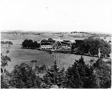
Photograph, View of Kangaroo Ground District from War Memorial Tower, 16 November 1951, 16 Nov. 1951
... It commands a magnificent 360 degree panorama from Kinglake across the Diamond Valley to Macedon and the You Yangs. It is built on a peak which was once a volcano, 237 metres above sea level. ...It commands a magnificent 360 degree panorama from Kinglake across the Diamond Valley to Macedon and the You Yangs. It is built on a peak which was once a volcano, 237 metres above sea level. ...View from Shire of Eltham War Memorial tower at Garden Hill, Kangaroo Ground, probably taken shortly after the memorial's re-dedication held 8 Nov. 1951. On November 11th 1926 the Shire of Eltham War Memorial Tower at Kangaroo Ground was opened. It is regarded as one of Melbourne’s most outstanding lookout towers. It commands a magnificent 360 degree panorama from Kinglake across the Diamond Valley to Macedon and the You Yangs. It is built on a peak which was once a volcano, 237 metres above sea level. After World War one a memorial cairn was erected on the site, and in 1925 a committee of public-minded citizens began to plan for a tower. Many generous donations of material and money were forthcoming so that in 1926 the Governor General Lord Stonehaven was able to unveil the plaque before a crowd of 500 people There was some concern in the 1960s when the Forests Commission wanted to build a firespotters cabin on the top. At first R.S.L. branches opposed the idea, but it was realised that this use could combine with its use as a tourist attraction, and would ensure its maintenance for the future. Today the Kangaroo Ground tower provides one of the best views around Melbourne and is a fitting memorial to those who died in two world wars. From: Historic items for Diamond Valley Community Radio September 1990 (EDHS collection) On November 8th, 1951, the memorial was re-dedicated by the Governor of Victoria, Sir Dallas Brookes with the addition of the names of men from the Shire of Eltham who fell in the Second World War. Further wreaths were added in time for the 2001 Reembrance Day service to commemorate the men from th shire who had fallen in the Malayan, Korean, Borneo and Vietnam campaigns.This photo forms part of a collection of photographs gathered by the Shire of Eltham for their centenary project book,"Pioneers and Painters: 100 years of the Shire of Eltham" by Alan Marshall (1971). The collection of over 500 images is held in partnership between Eltham District Historical Society and Yarra Plenty Regional Library (Eltham Library) and is now formally known as the 'The Shire of Eltham Pioneers Photograph Collection.' It is significant in being the first community sourced collection representing the places and people of the Shire's first one hundred years.Digital image 120 format B&W negative B&W Print 12.5 x 17.5 cmsepp, shire of eltham pioneers photograph collection, kangaroo ground, garden hill, kangaroo ground tower, lookout, memorial park, panorama, shire of eltham war memorial, view, vista -
 The Beechworth Burke Museum
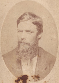
Photograph - Carte de Visite, James Bray, 1870
... These cards were exchanged during the Victorian era (peaking in the 1860s) between families and friends. ...These cards were exchanged during the Victorian era (peaking in the 1860s) between families and friends. ...A Carte de Visite (hereafter CdV) (also known as a calling card) was popular within the mid-19th Century. It is a small card with a photographic portrait mounted on it. These cards were exchanged during the Victorian era (peaking in the 1860s) between families and friends. This particular CdV was captured by James Bray in c.1870. Bray who worked as a professional photographer in Camp Street Beechworth from 1870-1891. He is renowned for his previous work photographing members of the Kelly gang. Depicted in this photograph is Isaiah “Wild” Wright. Wright was born in approximately 1846 in County Monaghan, Ireland. At age 11, Wright arrived with his father John Wright, mother Margaret and younger siblings in Victoria on the 9th of July 1857. They sailed on the ship ‘Carleton’ which left from Liverpool in England. Wright was stood 5 foot 11 inches tall and had brown hair with hazel eyes. He had a scar on the inside corner of his left eyebrow, a large scar on his right cheek and a scar on the back of his head. Over the years in Australia, Wright was sentenced on numerous (particularly of horse theft) charges and spent time in Pentridge, Hulk Sacramento and Hulk Sandridge. Wright married Bridget Lloyd in 1973. Through this marriage he was connected to the Kelly family as Bridget’s mother was one of Ellen Kelly’s (Ellen was the mother of Edward “Ned” Kelly) sisters. Wright is famous for his participation in the horse stealing incident of 1871 and subsequent bare knuckle fight against Ned Kelly that occurred in 1874. In 1878, Bridget and Isaiah Wright became parents to John "Jack" Thomas Wright. Jack Wright was an Australian rules footballer who played for Geelong in the Victorian Football League 1902-1906. Wright passed away on the 29th of May 1911.This photograph is part of the Burke Museum "Kelly album" which includes a significant collection of photographs and artefacts connected to Ned Kelly and the Kelly Gang. Ned Kelly and his gang have become ingrained in Australian popular culture and thus many museums, art galleries and private collections house material connected to the Kelly story which allows the events and people to be researched and interpreted. Individuals like Isaiah “Wild” Wright played an essential part in the Kelly story which have been enlarged and adapted for popular culture. The study of these individuals thorugh their images and records can help researchers to correctly interpret their involvement with Ned Kelly and the Kelly gang. Artefacts and photographs pertaining to the Kelly gang are particularly valuable for Australian museums. This particular photograph is significant for its connection to Beechworth photographer James Bray who is responsible for many images depicting members of the Kelly Gang. Sepia oval CDV printed on Card. Obverse: J.E. Bray/ Photo Reverse: 10238 Portrait & Landscape/ Photographer J E Bray Signature Beechworth/ Victoria/ Negatives Kept. Copies 5I/. Each May/ Be Had By Forwarding Name And Address/ Accompanied With Remittance To/ The Amount Of Order/ Photographs Coloured In Watercolourskelly album, kelly gang, beechworth, wild wright, boxing, burke museum, imperial hotel, bare-knuckle boxing, isaiah wright, ned kelly, isaiah wild wright, horse theft, hulk sacramento, calling card, pentridge, james bray, cdv, carte de visite -
 Bendigo Historical Society Inc.
Document - Fortuna - Health, Reports and Risk Assessments of the Site, 2008
... The firstimprovements at Fortuna were undertaken by the Ballerstedt family and consisted of a small mill and house. At the peak of the mining era (c.1860s) Fortuna was central to the deep alluvial gold mining operations of Bendigo. ...The firstimprovements at Fortuna were undertaken by the Ballerstedt family and consisted of a small mill and house. At the peak of the mining era (c.1860s) Fortuna was central to the deep alluvial gold mining operations of Bendigo. ...Theodore Ballerstedt originally purchased the Fortuna site from the Crown in 1857. The firstimprovements at Fortuna were undertaken by the Ballerstedt family and consisted of a small mill and house. At the peak of the mining era (c.1860s) Fortuna was central to the deep alluvial gold mining operations of Bendigo. In 1871 Theodore Ballerstedt sold the house, mine and associated works to George Lansell 'The Quartz King'. During his time at Fortuna, Lansell owned 13 mines and directed a further 73 in Bendigo. The primary building on the site is the Fortuna Villa. With the wealth Lansell generated from gold mining he funded the continuous expansion of the Villa and surrounding grounds. The Villa is built in a number of architectural styles, namely Victorian Italianate and Victorian Free Classical, with Federation influences. The surrounding landscape featured up to seven decorative lakes in the early 1870s, including one larger lake which still remains today. The former lakes were originally used as disposal points for tailings produced in the gold processing activities at the site. Fortuna was occupied by the Department of Defence from 1942 and was compulsorily acquired for Army use in 1957. Since that time Fortuna has been occupied by the Army and other various Defence organisations. During Defence's ownership, additional buildings were constructed and existing buildings were modified for re-use. In 1992 Defence purchased the adjoining undeveloped property, commonly known as the Bush Block. This parcel of land adjoins the main Fortuna landholding. It is approximately 0.8 hectares in size and is predominately covered in vegetation regrowth. Heritage investigations note that the uniqueness of Fortuna lies in the mixture of architectural styles of the Villa. The relationship between mining and domestic areas and the. close proximity of the two is considered rare to Australian domestic building of that time.Fortuna - Health, Reports and Risk Assessments of the Site This item contains the following documents: 11217.75a Fortuna Defense Site - Health Risk Assessment Final Report - 50 pages and appendices A to M - Contact the BHS for details 11217.75b Fortuna Defense Site - Structural inspection and report on various buildings, Department of Defence, Fortuna Site, 30 Chum Street Bendigo - Contact the BHS for details 11217.75c Fortuna Defense Site - Department of Defence Summary Report on Property Disposals Bendigo - Contact the BHS for details 11217.75d Fortuna Defense Site - Department of Defence Report on unexploded ordnance - Contact the BHS for details 11217.75e Fortuna Defense Site - Department of Defence Phase 1 Summary Report on Property Disposals Bendigo - Contact the BHS for details 11217.75f Fortuna Defense Site - Health Risk Assessment Final Report - 50 pages and appendices A to M - Contact the BHS for details 11217.75g Fortuna Defense Site - Environmental Site Assessment - Contact the BHS for detailsnon-fictionbendigo, fortuna, george lansell -
 The Beechworth Burke Museum
Photograph, c1960
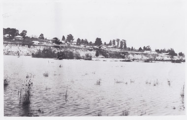
... The present day park and reserve occupies the site of the former Rocky Mountain Mining Company, an open-cut sluice mine that began operations in the mid-Nineteenth Century and operated until the early 1900s, through the peak of Victoria’s Gold Rush. It was converted into a park and leisure area in the 1920s. ...The present day park and reserve occupies the site of the former Rocky Mountain Mining Company, an open-cut sluice mine that began operations in the mid-Nineteenth Century and operated until the early 1900s, through the peak of Victoria’s Gold Rush. It was converted into a park and leisure area in the 1920s. ...The photograph depicts a view across the water at Lake Sambell. The image is thought to date from the 1960s so may show the lake during a period of drought, such as that experienced across South-Eastern Australia in 1967. The present day park and reserve occupies the site of the former Rocky Mountain Mining Company, an open-cut sluice mine that began operations in the mid-Nineteenth Century and operated until the early 1900s, through the peak of Victoria’s Gold Rush. It was converted into a park and leisure area in the 1920s. Lake Sambell was formally opened to the public on Friday 5th October 1928 and was opened by the Victorian Government’s Minister of Lands, Mr Bailey, as part of initiatives to boost the economies and development of country towns. The lake was named after Mr L.H. Sambell, a shire engineer and secretary of the Forward Beechworth Committee who was involved in promoting the transformation of the mining site and promoting plantation forestry and tourism as alternative industries. £300 to begin the process was provided by Mr J. McConvill, a former resident of Beechworth, who is remembered in a street name adjacent to the lake. Residents of Beechworth have worked to raise funds to improve the Lake Sambell reserve several times, such as efforts in the 1930s and 1940s to raise the banks several feet to deepen the water for swimming purposes. Fundraising campaigns include the ‘Ugly Man’ competition conducted on behalf of the Wallace Park-Lake Sambell Development Scheme. The latter competition was run by the Fire Brigade Bend’s team as part of a larger competition called the ‘Mile of Pennies’; it was won by Mr Len Knight of Beechworth’s Commercial Hotel. The ‘Mile of Pennies’ was conducted at a Carnival held on New Year’s Eve, 1947. It was proposed by the Beechworth and District Progress Association. As well as improving swimming facilities, funds were raised to install a caravan park facility near the lake. Funds were also donated by commercial entities, such as £250 received from Zwar Bros. Pty Ltd.The photograph is significant as it shows Lake Sambell at lower water levels, such as may have been experienced during period of drought.Sepia rectangular photograph printed on matte photographic paperObverse: nil Reverse: 3470beechworth, beechworth lake, lake sambell, lake, beechworth and district progress association, forward beechworth committee, ugly man, mile of pennies, wallace park lake sambell development scheme, wallace park-lake sambell development scheme, zwar bros, zwar, l.h. sambell, j. mcconvill, minister of lands, commercial hotel, len knight, rocky mountain mining company, rocky mountain mining co, gold rush, redevelopment, transformation, community fundraising, drought, 1967, 1960s -
 The Beechworth Burke Museum
Photograph - Lantern Slide, c1900
... These individuals, as well as many others who were brought from surrounding institutions, exhibited behaviours that were deemed to be unfit for mainstream society. At its peak, the asylum consisted of sixty-seven buildings and housed over twelve-hundred patients and five-hundred staff. ...These individuals, as well as many others who were brought from surrounding institutions, exhibited behaviours that were deemed to be unfit for mainstream society. At its peak, the asylum consisted of sixty-seven buildings and housed over twelve-hundred patients and five-hundred staff. ...This glass slide captures a scene from a male hospital ward at Mayday Hills Mental Asylum. Also known as the Beechworth Lunatic Asylum, Mayday Hills was officially opened on the twenty-fourth of October 1867 and was commissioned following lobbying from Beechworth Municipal Council concerning a need for better living conditions for individuals confined to the town's gaol. These individuals, as well as many others who were brought from surrounding institutions, exhibited behaviours that were deemed to be unfit for mainstream society. At its peak, the asylum consisted of sixty-seven buildings and housed over twelve-hundred patients and five-hundred staff. At the time of Australian Federation in 1901 - just a year after this photograph was taken - the patient population numbered six-hundred and seventy-four. The asylum was officially closed in 1996. It is listed on the Victorian Heritage Register as being architecturally significant. The extensive complex of buildings are examples of Italianate-style, which is strongly associated with asylums of the 1860s - the period in which construction of this particular asylum began. Today the asylum offers tours to visitors, including daytime history tours and night-time ghost tours. Lantern slides, sometimes called 'magic lantern' slides, are glass plates on which an image has been secured for the purpose of projection. Glass slides were etched or hand-painted for this purpose from the Eighteenth Century but the process became more popular and accessible to the public with the development of photographic-emulsion slides used with a 'Magic Lantern' device in the mid-Nineteenth Century. Photographic lantern slides comprise a double-negative emulsion layer (forming a positive image) between thin glass plates that are bound together. A number of processes existed to form and bind the emulsion layer to the base plate, including the albumen, wet plate collodion, gelatine dry plate and woodburytype techniques. Lantern slides and magic lantern technologies are seen as foundational precursors to the development of modern photography and film-making techniques.This glass slide is socially and historically significant as it is representative of the lives of the nurses and patients at Beechworth Mayday Hills Asylum in the early twentieth century. It is also historically significant as it is representative of the changing style of treatments and attitudes towards mental illness. Thin translucent sheet of glass with a circular image printed on the front and framed in a black backing. It is held together by metal strips to secure the edges of the slide.Obverse: h /lantern slide, slide, glass slide, plate, burke museum collection, photograph, monochrome, mayday hills, mayday hills hospital, mayday hills asylum, beechworth lunatic asylum, beechworth mental asylum, psychiatric hostpital, beechworth, burke museum, beechworth municipal council, beechworth patients, psychiatric patients, victorian heritage register, 1900, 1900 mayday hills, italianate style, 19th century asylums, asylums victoria, male ward mayday hills -
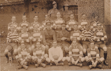 The Beechworth Burke Museum
Photograph
... Both sport and war demand peak physical fitness, camaraderie, strategy, and allegiance to a team collaboratively working towards a common goal: to win. ...Both sport and war demand peak physical fitness, camaraderie, strategy, and allegiance to a team collaboratively working towards a common goal: to win. ...Taken some time between 1914-18, depicted is a large group of unidentified males. Four of them are dressed in Australian military uniforms. The remaining 19 men are dressed in striped uniforms. The male in the centre of the front row is cradling a football, suggesting that the group was part of a football or rugby league team. It is believed that the soldiers in this photograph were part of the Australian Imperial Force. This can be inferred by the chevron rank insignia visible on their uniforms. The placement of this insignia on the sleeve of the right arm suggests that this soldier was either a Warrant Officer or a Non-Commissioned Officer (NCO). Additionally, they are also wearing 'Rising Sun' collar badges on their coats. Australia, unlike most other Commonwealth countries, did not adopt metal regimental badges during the First World War. All units were issued with the Australian Army General Service Badge, better known as the 'Rising Sun’ badge. This insignia is almost always identified with the Australian Imperial Force. Sport has always been entwined with war. Both sport and war demand peak physical fitness, camaraderie, strategy, and allegiance to a team collaboratively working towards a common goal: to win. The connection between sport and war is especially strong in Australia since these two concepts form the basis of our national identity. The Australian War Memorial has a number of World War I recruitment posters linking war and sport in its collection. One of the posters produced in 1915 by the State Parliamentary Recruiting Committee in Victoria attempted to shame young men into enlisting by juxtaposing the image of an Australian soldier standing guard over his deceased mate with a photograph of a Victorian Football League match. Another poster, produced in 1917, features vignettes of different sports including cricket, bowling, boxing, kayaking and golf. Its slogan reads, "Join Together - Train Together - Embark Together - Fight Together: Enlist in the Sportman's 1000".The record is historically significant due to its connection to World War I. This conflict is integral to Australian culture as it was the single greatest loss of life and the greatest repatriation of casualties in the country's history. Australia’s involvement in the First World War began when the Australian government established the Australian Imperial Force (AIF) in August 1914. Immediately, men were recruited to serve the British Empire in the Middle East and on the Western Front. The record has strong research potential. This is due to the ongoing public and scholarly interest in war, history, and especially the ANZAC legend, which is commemorated annually on 25 April, known as ANZAC Day. Additionally, the record presents a unique opportunity to further explore the relationship between the arts, sport and war. This statement of significance has already established that war is integral to Australia's national identity - and sport is of equal importance. Specifically, the record begs to question how the peak physical fitness and camaraderie valued in team sports were creatively translated into military recruitment campaigns during World War I. Evidently, this record and its historic context demonstrates that there is potential here, and if further research is completed on this topic, it may provide insight into Australian military recruitment tactics used in the past and present, and into the future.Sepia rectangular photograph printed on matte photographic paper mounted on card.Reverse: 6529 / hyossest (?) / (?)1/11/1 /military album, army, military, war, wwi, world war i, sport, football, rugby, aif, australian imperial force -
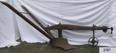 Flagstaff Hill Maritime Museum and Village
Tool - Plough, Syracuse Chilled Plow Co, 1876-1900
... The company was originally founded as the Robinson Chilled Plough Company in 1876 and changed its name 3 years later. At its peak, in the early 20th century. The company made more than 100,000 horse-drawn ploughs and road scrapers of various designs that were sold from the Syracuse plant each year and exported around the world. ...The company was originally founded as the Robinson Chilled Plough Company in 1876 and changed its name 3 years later. At its peak, in the early 20th century. The company made more than 100,000 horse-drawn ploughs and road scrapers of various designs that were sold from the Syracuse plant each year and exported around the world. ...The Syracuse Chilled Plough Company was created in 1876 and specialised in the manufacture of agricultural ploughs. Harry Wiard invented the chilling process in plough manufacture. The company was originally founded as the Robinson Chilled Plough Company in 1876 and changed its name 3 years later. At its peak, in the early 20th century. The company made more than 100,000 horse-drawn ploughs and road scrapers of various designs that were sold from the Syracuse plant each year and exported around the world. The company slogan of the day was, “The sun never sets on a Syracuse plough." Eventually, other farming implements were added to the line. The company employed more than 300 people in its local plant, which covered a square block on the cities Near West Side. In 1910-11, Deere and Company began expanding its holdings, and with the success of the Syracuse Chilled Plough Company, Deere sought to acquire the company. The management of the Syracuse operation after John Deere took over remained in the hands of Wiard and Chase, and the manufacturing operations were left in Syracuse. The only change from previous Syracuse operations was the selling of the companies products through Deere retail outlets instead of directly to the trade. The factory in Syracuse continued to produce ploughs until 1955. The subject item in the Flagstaff collection is an early model Syracuse Chilled plough with a wooden beam frame it is very much lighter in weight and was adapted to work sandy or light loamy soil. This plough has a sloping landside, which tends to keep the clods and dirt from falling into the furrow, making the ploughman's work much more comfortable and easy. This design was made in eight sizes for both right and left-handed ploughing and became very popular in the far West and South of the USA. Note: The definition of a chill plough means : a plough having the share and mould-board of chilled semi steel or cast iron.The subject item is believed to be a very early plough given its wooden beam frame and was made before 1900 probably around 1880. This makes it a significant example of the types of plough that early settlers were using in Victoria. There would not be very many of this type of vintage plough left with a wooden beam and frame, making it today a desirable collector's item. Syracuse Wood Beam Chilled single furrow plough metal wheel in front. Syracuse Chiller Co Syracuse & 50 L stamped on ploughshare.flagstaff hill, warrnambool, shipwrecked-coast, flagstaff-hill, flagstaff-hill-maritime-museum, maritime-museum, shipwreck-coast, flagstaff-hill-maritime-village, plough, syracuse chiller co, chiller plourh, farm equipment, furrow -
 Bendigo Historical Society Inc.
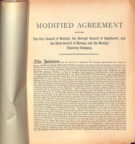
Booklet - Bendigo Tramways Agreement between City of Bendigo, Borough of Eaglehawk, Shire of Marong and Bendigo Tramway Company
... These were a success from the very beginning. During peak hour people would be standing in the aisles, in the doorways, even on the running boards on the outside of the tram. ...These were a success from the very beginning. During peak hour people would be standing in the aisles, in the doorways, even on the running boards on the outside of the tram. ...The Sandhurst and Electric Tramway Company was the first to blaze a trail when it introduced battery trams to Bendigo in June 1890. Unfortunately they had made a serious miscalculation, as the batteries quickly proved inadequate for the hilly terrain of Bendigo. After a couple of months battery trams ceased running and were later replaced by steam trams in February 1892. Steam trams were a reliable means of transport and successfully moved Bendigonians around for ten years, but the onset of the recession forced the Bendigo Tramways Company to sell up in 1899 to the Electric Supply Company of Victoria (ESCo) who continued to run steam trams until 1902. This turn-of-the-century sale led to the introduction of electric trams to Bendigo in April 1903. These were a success from the very beginning. During peak hour people would be standing in the aisles, in the doorways, even on the running boards on the outside of the tram. In addition, the trams were also the first option for deliveries. Parcels, newspapers, movie reels for the picture theatres and even mail bags found their way onto the trams; sent from outlying post offices to the GPO in the city centre. At the end of World War I the Victorian Government constituted the new semi-government instrumentality, the State Electricity Commission of Victoria (SEC). The SEC was to take over all privately owned power generating companies in Victoria and operate as a state owned monopoly ... Bendigo's tramway system was an integral part of the deal. The outbreak of World War II was a testing time. Revenue and passenger numbers were declining as automobiles became more popular. Additionally, shortages in manpower and materials due to wartime economies caused difficulties. As a result, the SEC made several attempts at closing the tramways and handing over the passenger services to private bus operators. It took some time, but in July 1970 the Victorian Parliament finally granted the SEC's application for abandonment of the tramways. April 1972 marked the closure of the Bendigo Tramways as a commuter service and an estimated 20,000 people gathered to say an emotional farewell.Booklet concerning Modified Agreement between City of Bendigo, Borough of Eaglehawk, Shire of Marong and Bendigo Tramway Company. Lime green paper cover without any text. Five pages. Agreement made September, 1891. Stapled at the spine to join cover and pages together. marong shire, city council of bendigo, council of bendigo, bendigo tramway company -
Bendigo Historical Society Inc.
Plan - Fortuna - Survey Unit Layouts, April 1982
... The firstimprovements at Fortuna were undertaken by the Ballerstedt family and consisted of a small mill and house. At the peak of the mining era (c.1860s) Fortuna was central to the deep alluvial gold mining operations of Bendigo. ...The firstimprovements at Fortuna were undertaken by the Ballerstedt family and consisted of a small mill and house. At the peak of the mining era (c.1860s) Fortuna was central to the deep alluvial gold mining operations of Bendigo. ...Theodore Ballerstedt originally purchased the Fortuna site from the Crown in 1857. The firstimprovements at Fortuna were undertaken by the Ballerstedt family and consisted of a small mill and house. At the peak of the mining era (c.1860s) Fortuna was central to the deep alluvial gold mining operations of Bendigo. In 1871 Theodore Ballerstedt sold the house, mine and associated works to George Lansell 'The Quartz King'. During his time at Fortuna, Lansell owned 13 mines and directed a further 73 in Bendigo. Fortuna was occupied by the Department of Defence from 1942 and was compulsorily acquired for Army use in 1957. Since that time Fortuna has been occupied by the Army and other various Defence organisations. During Defence's ownership, additional buildings were constructed and existing buildings were modified for re-use. In 1992 Defence purchased the adjoining undeveloped property, commonly known as the Bush Block. This parcel of land adjoins the main Fortuna landholding. It is approximately 0.8 hectares in size and is predominately covered in vegetation regrowth. Heritage investigations note that the uniqueness of Fortuna lies in the mixture of architectural styles of the Villa. The relationship between mining and domestic areas and the. close proximity of the two is considered rare to Australian domestic building of that time. The primary building on the site is the Fortuna Villa. With the wealth Lansell generated from gold mining he funded the continuous expansion of the Villa and surrounding grounds. The Villa is built in a number of architectural styles, namely Victorian Italianate and Victorian Free Classical, with Federation influences. The surrounding landscape featured up to seven decorative lakes in the early 1870s, including one larger lake which still remains today. The former lakes were originally used as disposal points for tailings produced in the gold processing activities at the site. Heritage investigations note that the uniqueness of Fortuna lies in the mixture of architectural styles of the Villa. The relationship between mining and domestic areas and the. close proximity of the two is considered rare to Australian domestic building of that time.Fortuna - Survey Unit Layouts This item contains the following documents: 11217.84a Layout of workspace and equipment used by the Army Survey Group 11217.84b Layout of workspace and equipment used by the Army Survey Group 11217.84c Layout of workspace and equipment used by the Army Survey Groupnon-fictionbendigo, fortuna, george lansell -
 Bendigo Historical Society Inc.
Drawing - Fortuna - Drawing Presented to Brian McLachlon, abt 2000
... The firstimprovements at Fortuna were undertaken by the Ballerstedt family and consisted of a small mill and house. At the peak of the mining era (c.1860s) Fortuna was central to the deep alluvial gold mining operations of Bendigo. ...The firstimprovements at Fortuna were undertaken by the Ballerstedt family and consisted of a small mill and house. At the peak of the mining era (c.1860s) Fortuna was central to the deep alluvial gold mining operations of Bendigo. ...Theodore Ballerstedt originally purchased the Fortuna site from the Crown in 1857. The firstimprovements at Fortuna were undertaken by the Ballerstedt family and consisted of a small mill and house. At the peak of the mining era (c.1860s) Fortuna was central to the deep alluvial gold mining operations of Bendigo. In 1871 Theodore Ballerstedt sold the house, mine and associated works to George Lansell 'The Quartz King'. During his time at Fortuna, Lansell owned 13 mines and directed a further 73 in Bendigo. Fortuna was occupied by the Department of Defence from 1942 and was compulsorily acquired for Army use in 1957. Since that time Fortuna has been occupied by the Army and other various Defence organisations. During Defence's ownership, additional buildings were constructed and existing buildings were modified for re-use. In 1992 Defence purchased the adjoining undeveloped property, commonly known as the Bush Block. This parcel of land adjoins the main Fortuna landholding. It is approximately 0.8 hectares in size and is predominately covered in vegetation regrowth. Heritage investigations note that the uniqueness of Fortuna lies in the mixture of architectural styles of the Villa. The relationship between mining and domestic areas and the. close proximity of the two is considered rare to Australian domestic building of that time. The primary building on the site is the Fortuna Villa. With the wealth Lansell generated from gold mining he funded the continuous expansion of the Villa and surrounding grounds. The Villa is built in a number of architectural styles, namely Victorian Italianate and Victorian Free Classical, with Federation influences. The surrounding landscape featured up to seven decorative lakes in the early 1870s, including one larger lake which still remains today. The former lakes were originally used as disposal points for tailings produced in the gold processing activities at the site. Heritage investigations note that the uniqueness of Fortuna lies in the mixture of architectural styles of the Villa. The relationship between mining and domestic areas and the. close proximity of the two is considered rare to Australian domestic building of that time.Fortuna - Drawing Presented to Brian McLachlon This item contains the following documents: 11217.77a Six copies Black and White drawing by Jason Nickson (cleaner) presented to Brian McLachlon on his transfer to the USA. Drawing shows Brian on a motor bike being farewelled by the Fortuna Villa (holding a baby named DIGO) and welcomed by the Statue of Liberty and the US flagnon-fictionbendigo, fortuna, george lansell, jason nickson fortuna cleaner, brian mclochlon fortuna -
 Warrnambool and District Historical Society Inc.
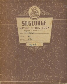
Work on paper - Booklets Fletcher Jones, 001143.1 Project Book 001143.2 Booklet:Plusites 001143.3 Flyer, Mid 20th century
... It tells of the royal visit of 1954 and other social events and items of interest around the various shops. 001143.3 Flyer :The text on this flyer also tells the story of the development of the Fletcher Jones brand to the point where there in the year2000 retail expansion was still happening but the Warrnambool workforce had shrunk from over 1000 at the peak to approximately 200. The company had commenced importing a range of clothing by this time ...It tells of the royal visit of 1954 and other social events and items of interest around the various shops. 001143.3 Flyer :The text on this flyer also tells the story of the development of the Fletcher Jones brand to the point where there in the year2000 retail expansion was still happening but the Warrnambool workforce had shrunk from over 1000 at the peak to approximately 200. The company had commenced importing a range of clothing by this time These three items present different views of a company which was an important part of industry in Warrnambool for over 60 years in the latter part of the 20th century. ...Fletcher Jones Clothing Factory was a key industry in Warrnambool from 1948 to its closure in 2005. The business was founded by David Fletcher Jones (1897-1977), a clothing manufacturer and retailer who worked as a hawker in the Western District following service with the A.I.F. in World War One. In 1924 Fletcher Jones opened three shops in Liebig Street selling men’s wear, hosiery and linen and operating a small tailoring business. He moved his shop to another location in Liebig Street and began to concentrate on men’s trousers production. In 1946 he opened a shop in Collins Street in Melbourne and eventually had stores and factories all over Australia. In Warrnambool he opened his factory at Pleasant Hill in Flaxman Street in 1948 and became a major Warrnambool employer, with over 1000 employees at one time. He transformed his business into a co-operative, with the name, ‘Fletcher Jones and Staff’ registered in 1947. The business diversified into other ranges of clothing for men and women but failed to compete with cheaper overseas clothing imports and the factory and shops were closed in the early 21st century. 001143.1 Project Book. This project book tells the story of the establishment and development of the Fletcher Jones company across the various stores which were established in Melbourne, Adelaide, Sydney, Geelong and Hobart. It explores the philosophy behind the business and milestones achieved and the factory gardens. The book itself provides an example of schoolwork completed in the mid 20th century. 001143.2 Booklet: Plusites: This is a staff booklet which has items of interest relating to staff such as births deaths and marriages. It tells of renovations and happenings in regard to the various shops around the country as well as trading figures. It tells of the royal visit of 1954 and other social events and items of interest around the various shops. 001143.3 Flyer :The text on this flyer also tells the story of the development of the Fletcher Jones brand to the point where there in the year2000 retail expansion was still happening but the Warrnambool workforce had shrunk from over 1000 at the peak to approximately 200. The company had commenced importing a range of clothing by this time These three items present different views of a company which was an important part of industry in Warrnambool for over 60 years in the latter part of the 20th century. The founder was one of Warrnambool’s most well respected people and many district people had connections to the firm. 001143.1 Project Book. Brown mottled card cover with cream insert for personal details. Back cover plain cream. It contains a student’s project work on the Fletcher Jones company. Some is handwritten and also contains a number of black and white photographs throughout the book. A coloured map of Australia is in the middle pages. 001143.2 Booklet: Plusites. White light card cover with dark blue text and diagram. Bottom left of page has a map of the coastline of Victoria. 20 pages. 001143.3 Flyer. Advertising Flyer re factory direct sales at Warrnambool. Black text with maroon border and Fletcher jones logo at the bottom and 4 photographs at the top. 001143.1 Project Book. T Cronin 4B WHS 001143.2 Booklet: Plusites. Vol 1 No 1 June 1954. 001143.3 Flyer fletcher jones, warrnambool history, fletcher jones and staff pty ltd -
 The Beechworth Burke Museum
Photograph - Lantern Slide, c1900
... These individuals, as well as many others who were brought from surrounding institutions, exhibited behaviours that were deemed to be unfit for mainstream society. At its peak, the asylum consisted of sixty-seven buildings and housed over twelve-hundred patients and five-hundred staff. ...These individuals, as well as many others who were brought from surrounding institutions, exhibited behaviours that were deemed to be unfit for mainstream society. At its peak, the asylum consisted of sixty-seven buildings and housed over twelve-hundred patients and five-hundred staff. ...Taken in approximately 1900, this glass slide captures an image of a Mayday Hills Mental Asylum nurse. Also known as the Beechworth Lunatic Asylum, Mayday Hills was officially opened on the twenty-fourth of October 1867 and was commissioned following lobbying from Beechworth Municipal Council concerning a need for better living conditions for certain individuals confined to the town's gaol. These individuals, as well as many others who were brought from surrounding institutions, exhibited behaviours that were deemed to be unfit for mainstream society. At its peak, the asylum consisted of sixty-seven buildings and housed over twelve-hundred patients and five-hundred staff. At the time of Australian Federation in 1901 - just a year after this photograph was taken - the patient population numbered six-hundred and seventy-four. The designated site of the institution was chosen due to its scenery and altitude. It was argued that these picturesque surroundings would assist in curing the hospital's patients of their ailments. The asylum was officially closed in 1996. It is listed on the Victorian Heritage Register as being architecturally significant. The extensive complex of buildings are examples of Italianate-style, which is strongly associated with asylums of the 1860s - the period in which construction of this particular asylum began. Today the asylum offers tours to visitors: both daytime history tours and night-time ghost tours. Lantern slides, sometimes called 'magic lantern' slides, are glass plates on which an image has been secured for the purpose of projection. Glass slides were etched or hand-painted for this purpose from the Eighteenth Century but the process became more popular and accessible to the public with the development of photographic-emulsion slides used with a 'Magic Lantern' device in the mid-Nineteenth Century. Photographic lantern slides comprise a double-negative emulsion layer (forming a positive image) between thin glass plates that are bound together. A number of processes existed to form and bind the emulsion layer to the base plate, including the albumen, wet plate collodion, gelatine dry plate and woodburytype techniques. Lantern slides and magic lantern technologies are seen as foundational precursors to the development of modern photography and film-making techniques.This glass slide is socially and historically significant as it is representative of the lives of the nurses who worked at Beechworth's Mayday Hills Asylum in the early twentieth century. Thin translucent sheet of glass with a portrait image printed on the front. It is held together by metal strips to secure the edges of the slide.burke museum, beechworth, lantern slide, slide, glass slide, plate, burke museum collection, photograph, monochrome, mayday hills, mayday hills mental asylum, beechworth asylum, beechworth asylum nurses, psychiatric nurses, psychiatric care, 1900 mayday hills, victorian heritage register, italianate style, 19th century asylums, asylums victoria -
 The Beechworth Burke Museum
Photograph - Lantern Slide, c1900
... These individuals, as well as many others who were brought from surrounding institutions, exhibited behaviours that were deemed to be unfit for mainstream society. At its peak, the asylum consisted of sixty-seven buildings and housed over twelve-hundred patients and five-hundred staff. ...These individuals, as well as many others who were brought from surrounding institutions, exhibited behaviours that were deemed to be unfit for mainstream society. At its peak, the asylum consisted of sixty-seven buildings and housed over twelve-hundred patients and five-hundred staff. ...Taken in approximately 1900, this glass slide captures an image of two Mayday Hills Mental Asylum nurses. Also known as the Beechworth Lunatic Asylum, Mayday Hills was officially opened on the twenty-fourth of October 1867 and was commissioned following lobbying from Beechworth Municipal Council concerning a need for better living conditions for certain individuals confined to the town's gaol. These individuals, as well as many others who were brought from surrounding institutions, exhibited behaviours that were deemed to be unfit for mainstream society. At its peak, the asylum consisted of sixty-seven buildings and housed over twelve-hundred patients and five-hundred staff. At the time of Australian Federation in 1901 - just a year after this photograph was taken - the patient population numbered six-hundred and seventy-four. The designated site of the institution was chosen due to its scenery and altitude. It was argued that these picturesque surroundings would assist in curing the hospital's patients of their ailments. The asylum was officially closed in 1996. It is listed on the Victorian Heritage Register as being architecturally significant. The extensive complex of buildings are examples of Italianate-style, which is strongly associated with asylums of the 1860s - the period in which construction of this particular asylum began. Today the asylum offers tours to visitors: both daytime history tours and night-time ghost tours. Lantern slides, sometimes called 'magic lantern' slides, are glass plates on which an image has been secured for the purpose of projection. Glass slides were etched or hand-painted for this purpose from the Eighteenth Century but the process became more popular and accessible to the public with the development of photographic-emulsion slides used with a 'Magic Lantern' device in the mid-Nineteenth Century. Photographic lantern slides comprise a double-negative emulsion layer (forming a positive image) between thin glass plates that are bound together. A number of processes existed to form and bind the emulsion layer to the base plate, including the albumen, wet plate collodion, gelatine dry plate and woodburytype techniques. Lantern slides and magic lantern technologies are seen as foundational precursors to the development of modern photography and film-making techniques.This glass slide is socially and historically significant as it is representative of the lives of the nurses who worked at Beechworth's Mayday Hills Asylum in the early twentieth century.Thin translucent sheet of glass with a portrait image printed on the front. It is held together by metal strips to secure the edges of the slide.burke museum, beechworth, lantern slide, slide, glass slide, plate, burke museum collection, photograph, monochrome, 1900 mayday hills, mayday hills, beechworth mental hospital, beechworth mental asylum, beechworth asylum nurses, psychiatric nurses, psychiatric care, victorian heritage register, italianate style, 19th century asylums, asylums victoria -
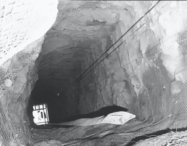 Bendigo Historical Society Inc.
Photograph - AUSTIN COLLECTION: Central Deborah Gold Mine Lift Shaft
... Central Deborah Gold Mine history: At its peak, Central Deborah Gold Mine reached a depth of 412 metres. ...History House 11 Mackenzie Street Bendigo goldfields Central Deborah Gold Mine history: At its peak, Central Deborah Gold Mine reached a depth of 412 metres. ...Central Deborah Gold Mine history: At its peak, Central Deborah Gold Mine reached a depth of 412 metres. It has 17 separate levels and 15 kilometres of drives and cross cuts (tunnels). The Central Deborah was very much a hands-on mine and the conditions that the miners worked in would be considered shocking by today's standards – being lowered underground in a cage with only two sides, often working ankle to knee deep in water, filling up to 32 ore trucks a shift by hand which were then pushed a mile or more along rails in the drives, working by carbide lamp, breathing in the fumes and rock dust and communication by bells. Geez, they were ironmen. However, at the time working conditions were considered to be among the best on the goldfields at Central Deborah, after all it was one of the only mines that had hot showers. Following Central Deborah Gold Mine's closure, the Bendigo skyline began to noticeably change. Obvious remnants of mining such as poppet heads, engine rooms, service quarters, battery houses and chimneys were steadily disappearing. After intense lobbying by the local community, the Bendigo City Council purchased the still very much intact Central Deborah Gold Mine in 1970 for a mere $6,000 to ensure that a vital link to Bendigo's historic golden past was maintained. The Bendigo Trust was then formed to oversee the operations of the Central Deborah Gold Mine, which led to the surface of the mine being opened to the public in 1971. Initially the surface was open for just 12 hours a week and as the demand for viewing a part of Bendigo's history increased, so did the opening hours. In 1974 the mine was gazetted as a Public Historical Purposes Reserve and attracted such visitors as H.R.H Prince Charles. By far the greatest shortcoming at this stage was that no one could view the underground workings, as these had become flooded. After what could only be described as a monumental effort by everyone involved, Level 2 of the mine was officially opened to the public by the Premier of Victoria, the Honourable John Cain, on 20 June 1986, which brought to fruition a long standing dream.Black and white photograph, looking from bottom of lift shaft towards the surface; light visible at top of shaft. Lift cables and safety mesh on sides of shaft. gold mining, central deborah gold mine, ray beer, mine manager -
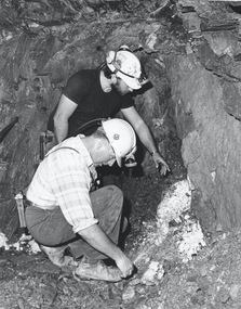 Bendigo Historical Society Inc.
Photograph - AUSTIN COLLECTION: Central Deborah Gold Mine, Possibly 1990's
... Central Deborah Gold Mine history: At its peak, Central Deborah Gold Mine reached a depth of 412 metres. ...History House 11 Mackenzie Street Bendigo goldfields Central Deborah Gold Mine history: At its peak, Central Deborah Gold Mine reached a depth of 412 metres. ...Central Deborah Gold Mine history: At its peak, Central Deborah Gold Mine reached a depth of 412 metres. It has 17 separate levels and 15 kilometres of drives and cross cuts (tunnels). The Central Deborah was very much a hands-on mine and the conditions that the miners worked in would be considered shocking by today's standards – being lowered underground in a cage with only two sides, often working ankle to knee deep in water, filling up to 32 ore trucks a shift by hand which were then pushed a mile or more along rails in the drives, working by carbide lamp, breathing in the fumes and rock dust and communication by bells. Geez, they were ironmen. However, at the time working conditions were considered to be among the best on the goldfields at Central Deborah, after all it was one of the only mines that had hot showers. Following Central Deborah Gold Mine's closure, the Bendigo skyline began to noticeably change. Obvious remnants of mining such as poppet heads, engine rooms, service quarters, battery houses and chimneys were steadily disappearing. After intense lobbying by the local community, the Bendigo City Council purchased the still very much intact Central Deborah Gold Mine in 1970 for a mere $6,000 to ensure that a vital link to Bendigo's historic golden past was maintained. The Bendigo Trust was then formed to oversee the operations of the Central Deborah Gold Mine, which led to the surface of the mine being opened to the public in 1971. Initially the surface was open for just 12 hours a week and as the demand for viewing a part of Bendigo's history increased, so did the opening hours. In 1974 the mine was gazetted as a Public Historical Purposes Reserve and attracted such visitors as H.R.H Prince Charles. By far the greatest shortcoming at this stage was that no one could view the underground workings, as these had become flooded. After what could only be described as a monumental effort by everyone involved, Level 2 of the mine was officially opened to the public by the Premier of Victoria, the Honourable John Cain, on 20 June 1986, which brought to fruition a long standing dream.Black and white photograph. Two men with hard hats and lights, inspecting quartz outcrop on wall of drive at Central Deborah Gold Mine.gold mining, central deborah gold mine, ray beer, mine manager -
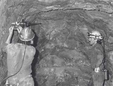 Bendigo Historical Society Inc.
Photograph - AUSTIN COLLECTION: Operating rock drill, Central Deborah Gold Mine, Possibly 1990's
... Central Deborah Gold Mine history: At its peak, Central Deborah Gold Mine reached a depth of 412 metres. ...History House 11 Mackenzie Street Bendigo goldfields Central Deborah Gold Mine history: At its peak, Central Deborah Gold Mine reached a depth of 412 metres. ...Central Deborah Gold Mine history: At its peak, Central Deborah Gold Mine reached a depth of 412 metres. It has 17 separate levels and 15 kilometres of drives and cross cuts (tunnels). The Central Deborah was very much a hands-on mine and the conditions that the miners worked in would be considered shocking by today's standards – being lowered underground in a cage with only two sides, often working ankle to knee deep in water, filling up to 32 ore trucks a shift by hand which were then pushed a mile or more along rails in the drives, working by carbide lamp, breathing in the fumes and rock dust and communication by bells. Geez, they were ironmen. However, at the time working conditions were considered to be among the best on the goldfields at Central Deborah, after all it was one of the only mines that had hot showers. Following Central Deborah Gold Mine's closure, the Bendigo skyline began to noticeably change. Obvious remnants of mining such as poppet heads, engine rooms, service quarters, battery houses and chimneys were steadily disappearing. After intense lobbying by the local community, the Bendigo City Council purchased the still very much intact Central Deborah Gold Mine in 1970 for a mere $6,000 to ensure that a vital link to Bendigo's historic golden past was maintained. The Bendigo Trust was then formed to oversee the operations of the Central Deborah Gold Mine, which led to the surface of the mine being opened to the public in 1971. Initially the surface was open for just 12 hours a week and as the demand for viewing a part of Bendigo's history increased, so did the opening hours. In 1974 the mine was gazetted as a Public Historical Purposes Reserve and attracted such visitors as H.R.H Prince Charles. By far the greatest shortcoming at this stage was that no one could view the underground workings, as these had become flooded. After what could only be described as a monumental effort by everyone involved, Level 2 of the mine was officially opened to the public by the Premier of Victoria, the Honourable John Cain, on 20 June 1986, which brought to fruition a long standing dream.Black and white photograph. Two men with hard hats and lights standing in front of underground rock surface at Central Deborah Gold Mine. Paul Maker on left hand side of image is operating a small rock drill. John Jeffrey on right hand side is observing the procedure. gold mining, central deborah gold mine, rock drill, underground -
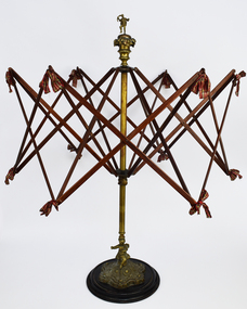 National Wool Museum
Functional object - Wool Winder, pre. 1950
... Originating from Scotland pre-1950, this wool winder is ornately decorated featuring a male figure at its peak and a cherub at its base. Wool Winders are practical objects typically with minimal decoration; however, Wool Winders with ornate design features do exist. ...National Wool Museum 26 Moorabool Street Geelong geelong-and-the-bellarine-peninsula Originating from Scotland pre-1950, this wool winder is ornately decorated featuring a male figure at its peak and a cherub at its base. Wool Winders are practical objects typically with minimal decoration; however, Wool Winders with ornate design features do exist. ...Originating from Scotland pre-1950, this wool winder is ornately decorated featuring a male figure at its peak and a cherub at its base. Wool Winders are practical objects typically with minimal decoration; however, Wool Winders with ornate design features do exist. Scrimshaw (whale ivory) was a popular choice of material in the 18th and 19th century. It is smooth, preventing yarn from getting caught when unwinding, as well as having artistic beauty. Wool winders require a heavy base, as to not topple over when in use. It is popular to decorate these bases on more elaborate winders, such as shown in this example. The bows featured to tie the wood segments together is another feature of more elaborate models of wool winders, also highlighted in this example. This winder began life in the possession of Annie Crawford. The Crawford name has a strong connection with the town of Paisley, Scotland, and its Woollen Mills. The Crawford name can be seen working at the Woollen Mills in the 1851 Scotland Census, with Robert and his brother’s James and John working as Wool dyers. Their father Alexander also worked as a Loom Weaver. The winder immigrated with Annie when she, her husband and 3 children travelled to Australia, ready to start a new life. Most of their possessions were left behind in Scotland. This winder accompanied the family on their journey; so it stands to reason that the winder was special to them. Annie Crawford passed the winder onto her eldest daughter Joan Crawford. Joan did not have any children and so she passed the winder onto the eldest female grandchild, Fiona Crawford. Fiona Crawford continued the connection of the Crawford name with textiles, with an exhibition titled "When you go looking for me, I am not there". Utilising medieval embroidery tradition of ‘Punto Assisi, the exhibition was a reflection on the lack of women recorded in history, particularly their contribution to the domestic arts. Her work investigates both the absence of women while also honouring the unknown female makers of this now highly desired art. The Wool Winder was donated to the National Wool Museum in 2021 by Dianne Crawford, the sister of Fiona Crawford. Umbrella swift style wool winder made of metal, wood, and ribbon. Decorated at its highest point with a sculpted man standing on one leg, holding what is perhaps a rolled newspaper as though he may be bidding at an auction. Or perhaps he is holding a hank of wool. The man stands upon a three-tier platform of decreasing size and design which leads to the central metal shaft. At the base, the winder is decorated with an engraved cherub. Both figures have a small hole in one of their hands, indicating that they originally held something. Unfortunately, it is not known what this is. From the central metal shaft, this winder has 2 rows of 6 arms radiating out. These arms cross in the middle to form an X. These arms are also connected horizontally with additional arms which cross. This all forms an intricate web design, tied together with ribbon. The size of the web these arms create is adjustable, to accommodate yarns of different length. Beneath the second row of arms is a locking screw which holds this row at the desired height and width. This entire top section, beginning at the central metal shaft, can be unscrewed from its base for easier storage. The base begins in a wooden circular shape growing into a smaller ornately designed raise on which the cherub sits. From the head of the cherub the central metal shaft begins.paisley, scotland, wool winder, immigration -
 Bendigo Military Museum
Uniform - SERVICE DRESS, ARMY, Australian Government Clothing Factory, 1981 - 1984
... Light green half hat band with a rising pointed peak at front attached with black elastic. ...Light green half hat band with a rising pointed peak at front attached with black elastic. ...Uniform items issued to "BROWNE" Service No. F3207137.Garments - dark green colour wool and polyester fabric. 1. Jacket - Winter service dress jacket - collarless, with two curved inset pockets at hip. Four gold colour plastic buttons with shank and metal safety pin. Buttons have raised emblem "Australian Army Psychology Corps". Dark green colour polyester fabric lining. Manufacturer's label at back below neckline. White cotton label. 2. Skirt - Winter Service Dress skirt. A-line skirt, narrow waistband, five belt loops. front of skirt pair of box pleats. Rear at waist, nylon and metal zipper and dark green plastic button. Dark green colour polyester fabric lining. Manufacturers label sewn to waistband lining. 3. Belt - self fabric belt with gold colour plastic buckle. 4. Slacks - Winter Service dress slacks - full length with five belt loops, front nylon and metal zipper fly, dark green colour plastic button at waist, Manufacturer's labels two outside back. 5. Belt - self fabric belt with keeper and metal press stud. 6. Hat - Service dress hat - dark green colour fabric split brim, turned down at front and up at rear with light green colour fabric three panel crown. Light green half hat band with a rising pointed peak at front attached with black elastic. Interior - black velveteen sweatband lining, crown lining dark green polyester fabric. Manufacturer's label sewn rear lining. Manufacturer's labels - black ink print. 1.& 2. "A.G.C.F. ^/VICTORIA 1981/ 8410-66-096-5154/ SIZE 14 AVE HEIGHT/FULL HIP/ 90cm BUST/ 70 cm WAIST 100 cm HIPS/ Wool & polyester/ Garment/ NAME / SERVICE NO" With garment care instructions. Handwritten - blue ink pen "BROWNE/ F3207137" 4. " A.G.C.F. VICTORIA 1984 ^ 1984/ 8410-66-096-5173 SIZE 14 AVE HGT/ AVE HIP Waist 70 cm/ Hip 96 cm/Name/ Service No". With garment care instructions. Outside back - 'THIS TAG IS FOR IDENTIFICATION PURPOSES ONLY/ PLEASE REMOVE BEFORE WEARING" with printed and handwritten information. 6. "EMERCO VIC./ ^/ 8410-66-097-4922/ SIZE 56/ NAME/ SERVICE NO".passchendaele barracks trust, uniform, winter service dress, army, browne -
 Royal District Nursing Service (now known as Bolton Clarke)
Photograph - Photograph, black and white, Barry Sutton, 24.04.1974
... The next lady, on the far right, has shoulder length black curly hair and is wearing dark grey slacks, and a black round neck jumper over a white blouse with the peaks and cuff seen....The next lady, on the far right, has shoulder length black curly hair and is wearing dark grey slacks, and a black round neck jumper over a white blouse with the peaks and cuff seen. Photograph Photograph, black and white Barry Sutton ...Sister Pat (Paddy) Rowley is the Principal Nurse Educator at Royal District Nursing Service (RDNS) and is standing with a group of RDNS staff in the Education Department at RDNS Headquarters, 452 St. Kilda Road, Melbourne. Sr. Rowley is wearing the RDNS winter uniform of a blue/grey skivvie under a blue/grey V neck tunic style dress made of herring bone winter material. She, and the lady in the white dress, are displaying the RDNS winter beret made of the same herringbone material as the RDNS winter dress.From its earliest years when the Trained nurses (Nurses) of Melbourne District Nursing Society (MDNS began to wear uniforms the chosen colour was grey, though the style changed throughout the years as fashions changed from the late 1800s through to the 1970s. Their Nurses firstly wore long grey frocks, and on their heads, a white cap with a long white tail hanging from the centre back. When bicycles were introduced the headgear changed to a white pith helmet adorned with a red Maltese cross in the centre front. This was held on with a veil going over the hat and tied under the chin. Over the years there were complaints that the veils became wet in the rain and they asked for a change of uniform, but this did not happen until 1921. Later the Trained nurses (Sisters) complained their skirts became wet when riding their bicycles in the rain and asked, when raining, to be able to wear breeches and gaiters. This was granted provided they wore aprons when attending patients. It was not long before the uniform changed to a shorter length grey frock, red cardigan, grey coat and grey brimmed hat; later changed to a peaked grey hat. In 1966 MDNS were granted Royal patronage. Now as Royal District Nursing Service (RDNS), the uniform was redesigned and colour changed in 1971. By 1972 the Sisters were wearing the new winter uniform of a blue/grey skivvie under a V neck tunic style frock made of blue/grey herringbone winter material with the RDNS insignia on the upper left, and a beret of the same material. In summer the uniform became a royal blue V neck tunic style frock, with the RDNS insignia on the upper left, worn over a short sleeve white blouse. A royal blue peaked hat with the RDNS insignia in the centre front was worn at first and then only worn on official occasions. This uniform was worn until changed to a corporate style in the mid 1980s,This black and white photograph depicts six Royal District Nursing Service (RDNS) staff standing in two rows in front of closed long grey curtains. They are looking at the camera and smiling, some are partly hidden. L- R back row - A lady who has short dark hair and is wearing a grey and black patterned frock. Next is a lady with her black hair drawn back; is wearing black pants and a black sleeveless V neck jacket over a white skivvie. The next lady has wavy short dark hair; is wearing white slacks, a light grey jacket with lapels and the pocket on its upper left has a vertical zip in the centre. She has a black and white striped scarf around her neck. Front row L-R - A lady with shoulder length black curled hair who is wearing a white uniform style dress and is turned toward the right of the photograph. Her right hand is on the top edge of an RDNS beret which is held on its edge with the inner white lining seen, and the upper section showing the deep front of the beret which has a central RDNS logo. To the right of this, is Sister Pat (Paddy) Rowley who has short dark straight hair; is wearing dark rimmed glasses and is wearing a light grey skivvie under a darker V neck tunic style dress. She is turned toward the left of the photograph and her right hand is holding the bottom edge of the RDNS beret and her left hand is on the top edge. The next lady, on the far right, has shoulder length black curly hair and is wearing dark grey slacks, and a black round neck jumper over a white blouse with the peaks and cuff seen.Barry Sutton MA 23 rdns, rdns education, royal district nursing service, rdns uniform, sister pat (paddy) rowley -
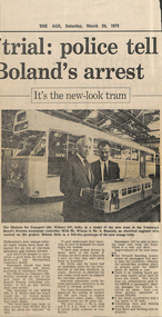 Melbourne Tram Museum
Newspaper, The Age, “It’s the new-look tram”, 24/03/1973 12:00:00 AM
... One-man operations could be used in off-peak periods. State Government recently approved calling of tenders for 100 new trams to replace Melbourne's oldest trams. 300 trams are 50 years old. ...One-man operations could be used in off-peak periods. State Government recently approved calling of tenders for 100 new trams to replace Melbourne's oldest trams. 300 trams are 50 years old. ...Newspaper clipping titled: The Age, 24/3/73 “It’s the new-look tram” Photo and text of Melbourne’s newest tram Minister for Transport, Mr Wilcox, look at model of new tram at Preston workshops. Mr S Bramich, electrical engineer, worked on project. Photo shows model of tram with full-size prototype behind the two men. Melbourne's new orange-coloured super trams have been designed for an era of one-man operators and women drivers. Cheaper to run. Passengers should find them more comfortable and faster. Will go into service early next month (April?). MMTB Chairman, RF Kirby said board would like to recruit women drivers for trams, especially new super trams. "...very keen to have women tram drivers. But union has objected." Kirby said board had no immediate plans for introduction of one-man operators but trams could be easily adapted. One-man operations could be used in off-peak periods. State Government recently approved calling of tenders for 100 new trams to replace Melbourne's oldest trams. 300 trams are 50 years old. New tram is 53 feet long and 8 feet 9 inches wide. Passengers will enter through front door and purchase ticket from seated conductor. Rear exit door. Improvements to new trams are:, forward boarding means all passengers have to pass conductor, reducing missed-fare problem costing about $1M per year, no running board and tram cannot move until all doors are closed. Reduce compensation payments to passengers for injuries, last year around $30K, faster acceleration and top speed of 45 mph, ventilating fans and heating during the winter, stop lights and flashing turn indicatorstrams, tramways, prototype tramcar, modelling, z class, preston workshops, minister for transport, mmtb chairman -
Surrey Hills Historical Society Collection
Work on paper - Vertical file, Brack, John
... ‘Raising the bar’, ‘The Age’, 20.3.2009 (1 page). 10. ‘An artist at peak hour’, ‘Good Weekend, The Age’, pre-1999 (5 pages). 11. ...‘Raising the bar’, ‘The Age’, 20.3.2009 (1 page). 10. ‘An artist at peak hour’, ‘Good Weekend, The Age’, pre-1999 (5 pages). 11. ...1. Notes by Ronald Millar from Australian Art Library – John Brack re ‘Surrey Gardens’ watercolour, 1961 (3 pages). 2. Extract from ‘Herald’, 5.2.1974; 3. Extract from ‘The Age, 26.7.1986 (both on 1 page). 4. ‘Art market back from the dead’, ‘The Weekend Australian’, 1.5.1999 (1 page). 5. ‘Older and wiser’, ‘The Weekend Australian’, 1.5.1999 (1 page). 6. ‘Brack and forth’, ‘The Weekend Australian’, 1.5.1999 (1 page). 7. ‘John Brack inside and outside, ‘Artlines’, Winter 2001, by Joanna Bosse (1 page); AND funeral notice 1999 with note re burial at Maldon cemetery. 8. ‘Money on the Bar as the six o’clock swill makes a comeback’, ‘The Age, 18.1.2006 (1 page). 9. ‘Raising the bar’, ‘The Age’, 20.3.2009 (1 page). 10. ‘An artist at peak hour’, ‘Good Weekend, The Age’, pre-1999 (5 pages). 11. ‘The lost course of John Brack’, ‘The Age’, 4.6.1983 (1 page on board). 12. ‘Truth found in the past’, Sun Artscene with Rod Carmichael, 1983 (1 page). 13. Extracts from National Gallery of Victoria ‘What’s on’ brochure, July-August, 2018 (2 pages). 14. ‘Brack portrait celebrates family and chaos’, Meaghan Wilson-Anastasios, Age, 13.6.2020, (3 pages). 15. ‘”Useless”: John Brack’s widow, Helen Maudsley, on art in the age of the selfie’, Lindy Percival, Sydney Morning Herald, 5.12.2017 (3 pages). 16. ‘Brack sums up his complex train of thought’, Christopher Heathcote, Age ?, 2009 ? undated (1 page). 17. ‘Brack’s back’, April 2000, unknown paper; AND ‘Brack, bucks, suburbia and beyond’, Ashley Crawford, source and date unknown (2 pages). 18. Copy of painting of Surrey Hills Gardens, 1961 (1 page). 19. Notes on Surrey Gardens painting by Ronald Millar (1 page). -
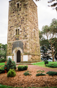 Eltham District Historical Society Inc
Photograph, Shire of Eltham War Memorial, Memorial Park, Garden Hill, Kangaroo Ground; Eltham Heritage Tour, 24 May 1992, 24/05/1992
... It commands a magnificent 360 degree panorama from Kinglake across the Diamond Valley to Macedon and the You Yangs. It is built on a peak which was once a volcano, 237 metres above sea level. ...It commands a magnificent 360 degree panorama from Kinglake across the Diamond Valley to Macedon and the You Yangs. It is built on a peak which was once a volcano, 237 metres above sea level. ...ELTHAM HERITAGE TOUR The Society excursion on 24th May 1992 was arranged by David Bick, leader of the team carrying out the Shire's heritage study. David selected a number of sites or buildings identified in the study, some of them lesser known components of the Shire's heritage. The tour commenced at the Eltham Shire Office at 10.00 am. Travel was by private car and mini-bus with stops at about twelve locations for commentary by David.It included a short walk in Hurstbridge and lunch at Kinglake. Highlights of the tour included: - 10 am Leave from Shire Offices - 3 Important Trees - A Physical Link to Eltham's First Settlers - Toorak Mansion Gates - A Surviving Farm House - An Intact Circa 1900 Main Street - First Settlers - Gold Miners, and Timber-getters - An Early Hotel - A Pioneering Homestead - Changing Eltham Shire - 20th Century - 4 pm Afternoon Tea and Finish Tour Extract from ELTHAM CULTURAL HERITAGE TOUR (Newsletter No. 85, July 1992, by Bettina Woodburn) "Now we drove through stands of pines to the Kangaroo Ground Lookout Tower, a most unusual War Memorial, World War I. The tower and a shed/residence (it had a chimney) were built from local sandstone. Below to the south and east of Melbourne spread 'suburbia'. Close by the landscape seemed so contrived - English fields and hedgerows! Although only about twenty inches deep, the soil of this ancient volcano, its crater lost under subsequent weathering, was rich, deserving the name of "Garden Hill". Now native trees are taking over again. In Kangaroo Ground itself stand the inevitable Store, School and Church - and two Norfolk pines and a monkey puzzle tree." On November 11th 1926 the Shire of Eltham War Memorial Tower at Kangaroo Ground was opened. It is regarded as one of Melbourne’s most outstanding lookout towers. It commands a magnificent 360 degree panorama from Kinglake across the Diamond Valley to Macedon and the You Yangs. It is built on a peak which was once a volcano, 237 metres above sea level. After World War one a memorial cairn was erected on the site, and in 1925 a committee of public-minded citizens began to plan for a tower. Many generous donations of material and money were forthcoming so that in 1926 the Governor General Lord Stonehaven was able to unveil the plaque before a crowd of 500 people. There was some concern in the 1960s when the Forests Commission wanted to build a firespotters cabin on the top. At first R.S.L. branches opposed the idea, but it was realised that this use could combine with its use as a tourist attraction, and would ensure its maintenance for the future, Today the Kangaroo Ground tower provides one of the best views around Melbourne and is a fitting memorial to those who died in two world wars. From: Historic items for Diamond Valley Community Radio September 1990 (EDHS collection) Record of the Society's history and activities and highlighting various aspects of the Heritage Study undertaken by David Bick used to create the future heritage overlay for the Shire of Eltham and later Nillumbik Shire.Roll of 35mm colour negative film, 4 stripsKodak Gold 100 5095culture, events, garden hill, kangaroo ground, kangaroo ground memorial, memorial park, shire of eltham war memorial tower, war memorials -
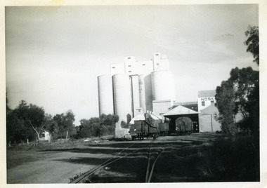 Charlton Golden Grains Museum Inc
Photograph, c.1960
... . ### Transformation of the Site At its peak, the mill was a major employer, providing work for approximately 65–70 men. .... ### Transformation of the Site At its peak, the mill was a major employer, providing work for approximately 65–70 men. ...Noske's mill in mid 1960s. Noske's Flour Mill, with its commanding presence and towering silos, has long **dominated the Charlton skyline** and remains a significant landmark, even though it no longer mills flour. The mill's history is deeply intertwined with the development of Charlton and the grain industry of the surrounding district. The foundation for the mill's presence was laid in 1919 when Messrs Noske Bros. Pty. Ltd., already owning mills in Horsham, Nhill, and Murray Bridge, acquired G. H. Foreman’s Mill located by the Avoca River. The founder, **T. J. Noske**, was an early pioneer of flour exporting, expanding his milling business after unexpectedly acquiring the Horsham mill. ### A State-of-the-Art Operation The original mill by the river operated until August 1926 before being closed and dismantled. Plans were well underway for a **new, state-of-the-art mill** to be located at the former Cobb and Co site. In 1927, the new mill began operation. It was one of the largest in the state, boasting a capacity of three tons of flour per hour, a 250 h.p. diesel engine, and three initial silos. The mill quickly gained a reputation for **excellence** for both its design and its flour, which was sold successfully in local and overseas markets. ### Periods of Expansion and Trial The mill continued to grow, reflecting the importance of the local agricultural industry. Between 1940 and 1941, **nine new silos** were built, adding bulk receival points. In the record-breaking 1968 season, the mill received a colossal wheat intake of **695,000 bushels**. However, the mill also faced setbacks. On January 21, 1949, disaster struck when a **large fire** erupted in the storage shed, which contained 500 tons of bagged flour ready for export and new flour bags. The blaze was so intense that smoke was visible as far away as Wycheproof, and it threatened to destroy the entire mill. Thanks to the monumental efforts of the Charlton, St. Arnaud, Wycheproof, and Wedderburn Brigades, who ran the main pump almost continuously for 26 hours, the damage was contained, though the estimated loss was a substantial £60,000. ### Transformation of the Site At its peak, the mill was a major employer, providing work for approximately 65–70 men. But after over 45 years of operation, flour production at the mill ceased on October 25, 1973. Noske Industries Ltd. sought to adapt, converting the operation to a less successful stock feed production centre. In 1977, the **Grain Elevators Board** took over the site as a grain receival depot, building a large elevator tower that surpassed the height of the original buildings. The site eventually returned to private hands and, since 2000, has been owned and operated as a primary grain receival site for **GrainCorp**, cementing its continued, vital role in Charlton's agricultural life.Black and white photograph with white border.charlton, business, noske's, flour mill -
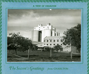 Charlton Golden Grains Museum Inc
Postcard, A view of Charlton. The seasons greeting from Charlton, c.1946
... . ### Transformation of the Site At its peak, the mill was a major employer, providing work for approximately 65–70 men. .... ### Transformation of the Site At its peak, the mill was a major employer, providing work for approximately 65–70 men. ...Eight silos added in 1940s. Noske's Flour Mill, with its commanding presence and towering silos, has long **dominated the Charlton skyline** and remains a significant landmark, even though it no longer mills flour. The mill's history is deeply intertwined with the development of Charlton and the grain industry of the surrounding district. The foundation for the mill's presence was laid in 1919 when Messrs Noske Bros. Pty. Ltd., already owning mills in Horsham, Nhill, and Murray Bridge, acquired G. H. Foreman’s Mill located by the Avoca River. The founder, **T. J. Noske**, was an early pioneer of flour exporting, expanding his milling business after unexpectedly acquiring the Horsham mill. ### A State-of-the-Art Operation The original mill by the river operated until August 1926 before being closed and dismantled. Plans were well underway for a **new, state-of-the-art mill** to be located at the former Cobb and Co site. In 1927, the new mill began operation. It was one of the largest in the state, boasting a capacity of three tons of flour per hour, a 250 h.p. diesel engine, and three initial silos. The mill quickly gained a reputation for **excellence** for both its design and its flour, which was sold successfully in local and overseas markets. ### Periods of Expansion and Trial The mill continued to grow, reflecting the importance of the local agricultural industry. Between 1940 and 1941, **nine new silos** were built, adding bulk receival points. In the record-breaking 1968 season, the mill received a colossal wheat intake of **695,000 bushels**. However, the mill also faced setbacks. On January 21, 1949, disaster struck when a **large fire** erupted in the storage shed, which contained 500 tons of bagged flour ready for export and new flour bags. The blaze was so intense that smoke was visible as far away as Wycheproof, and it threatened to destroy the entire mill. Thanks to the monumental efforts of the Charlton, St. Arnaud, Wycheproof, and Wedderburn Brigades, who ran the main pump almost continuously for 26 hours, the damage was contained, though the estimated loss was a substantial £60,000. ### Transformation of the Site At its peak, the mill was a major employer, providing work for approximately 65–70 men. But after over 45 years of operation, flour production at the mill ceased on October 25, 1973. Noske Industries Ltd. sought to adapt, converting the operation to a less successful stock feed production centre. In 1977, the **Grain Elevators Board** took over the site as a grain receival depot, building a large elevator tower that surpassed the height of the original buildings. The site eventually returned to private hands and, since 2000, has been owned and operated as a primary grain receival site for **GrainCorp**, cementing its continued, vital role in Charlton's agricultural life.Large landscape black and white photo set on a blue card backing. The card has a green holly leaf pattern embossed on the edge.A view of Charlton. The Season's Greetings from Charlton.charlton, noske bros, noske's, flour mill -
Glenelg Shire Council Cultural Collection
Administrative record - Hire Purchase Agreement, c. 1939
... In 1921 Healing’s son Keith joined the firm and became an apprentice bicycle maker and Healing cycles grew more popular and at peak production 25,000 bicycles were made per year. ...In 1921 Healing’s son Keith joined the firm and became an apprentice bicycle maker and Healing cycles grew more popular and at peak production 25,000 bicycles were made per year. ...From Aussie Velos: Alfred George Healing was born in 1868 in the suburb of Richmond, Melbourne (VIC). Starting in the cycle industry as a cycle builder and repairer in 1898, he obtained the Victorian agency for the English “Haddon” bicycle located on Bridge Road, Richmond. With many years behind him in the bicycle industry in 1907 he opened a small shop from borrowing £50 from his sister and began operating as A.G Healing. Importing bicycle parts Healing was quickly gaining a reputation for his quality and service among the cycling community, with steady business growth, Healing stumbled across an error that had been made in a recent order which resulted in twice the number of bicycle parts received. With no finances to pay for them, Healing decided to cycle around Victoria selling these parts to make the money he needed to fix up the order. As Healing travelled across Victoria he found that there was such a large market place for cycling gear that the order was soon fixed. It became apparent that Healing needed to open cycle shops in various locations. By 1912 Healing decided to open up his own proprietary company in Niagara Lane, Melbourne (VIC), the company was surging with enthusiastic cyclists and commuters and other branches began to spread all over state of Victoria. In 1921 Healing’s son Keith joined the firm and became an apprentice bicycle maker and Healing cycles grew more popular and at peak production 25,000 bicycles were made per year. Shops under the name of Healing were now operating across Australia. The business was now transferred to another location of Melbourne House, Post-office place (MELB). In 1926 Duncan and Co. wholesale and retail distributors of automotive parts was absorbed and was occupied in a larger building in Franklin Street (MELB) to maintain the warehouse operations. A.G Healing was now a public company. By 1933 the firm also began to specialize in importing radios and later began to make their own. One of the many Champions who rode on a Healing cycle was W.K “Bill” Moritz. His achievements included winning all major events in Australia and New Zealand during the years of 1936-37 path racing season. In 1936 Healing released a lightweight cycle that would rule in their supreme line-up, built from the lightest possible materials, the frame and forks were chrome plated, stripped for racing weighed exactly 16 1/2 lbs. It was fitted with special “Osgear” three-speed gear and built specially built for D. Byrant. By 1937, Healing cycles were being ridden by many, at the exhibition board track Jack Molloy won the Victorian ten-mile amateur championship, Bill Moritz captured the five mile professional, and Tassle Johnson the five-mile amateur scratch race. These wins brought up the total championships won in one week by Healing cycles to six.A hire agreement (hire purchase) between H.L. Vivian and R&G Finances Pty Ltd, for a Healing 'A' bicycle, with Eadie Coaster Hub brake. -
 Charlton Golden Grains Museum Inc
Photograph, Charlton Shire, Charlton Flour Mill, c.1987
... . ### Transformation of the Site At its peak, the mill was a major employer, providing work for approximately 65–70 men. .... ### Transformation of the Site At its peak, the mill was a major employer, providing work for approximately 65–70 men. ...A previous mill had operated in Charlton by Mr. W.E. Foreman on the banks of the Avoca River and was acquired in 1919 by Noske Bros. The present Flour Mill was built by Noske Bros and opened in May 1927. It was taken over by the Grain Elevator Board in the 1970s. Noske's Flour Mill, with its commanding presence and towering silos, has long **dominated the Charlton skyline** and remains a significant landmark, even though it no longer mills flour. The mill's history is deeply intertwined with the development of Charlton and the grain industry of the surrounding district. The foundation for the mill's presence was laid in 1919 when Messrs Noske Bros. Pty. Ltd., already owning mills in Horsham, Nhill, and Murray Bridge, acquired G. H. Foreman’s Mill located by the Avoca River. The founder, **T. J. Noske**, was an early pioneer of flour exporting, expanding his milling business after unexpectedly acquiring the Horsham mill. ### A State-of-the-Art Operation The original mill by the river operated until August 1926 before being closed and dismantled. Plans were well underway for a **new, state-of-the-art mill** to be located at the former Cobb and Co site. In 1927, the new mill began operation. It was one of the largest in the state, boasting a capacity of three tons of flour per hour, a 250 h.p. diesel engine, and three initial silos. The mill quickly gained a reputation for **excellence** for both its design and its flour, which was sold successfully in local and overseas markets. ### Periods of Expansion and Trial The mill continued to grow, reflecting the importance of the local agricultural industry. Between 1940 and 1941, **nine new silos** were built, adding bulk receival points. In the record-breaking 1968 season, the mill received a colossal wheat intake of **695,000 bushels**. However, the mill also faced setbacks. On January 21, 1949, disaster struck when a **large fire** erupted in the storage shed, which contained 500 tons of bagged flour ready for export and new flour bags. The blaze was so intense that smoke was visible as far away as Wycheproof, and it threatened to destroy the entire mill. Thanks to the monumental efforts of the Charlton, St. Arnaud, Wycheproof, and Wedderburn Brigades, who ran the main pump almost continuously for 26 hours, the damage was contained, though the estimated loss was a substantial £60,000. ### Transformation of the Site At its peak, the mill was a major employer, providing work for approximately 65–70 men. But after over 45 years of operation, flour production at the mill ceased on October 25, 1973. Noske Industries Ltd. sought to adapt, converting the operation to a less successful stock feed production centre. In 1977, the **Grain Elevators Board** took over the site as a grain receival depot, building a large elevator tower that surpassed the height of the original buildings. The site eventually returned to private hands and, since 2000, has been owned and operated as a primary grain receival site for **GrainCorp**, cementing its continued, vital role in Charlton's agricultural life. Colour photograph of Charlton Flour Mill and silos. Intersection of Kaye & Davies Streets in the foreground. One large silver silo and three taller greyish concrete silos to the left. Three other cream coloured silos behind. There are pipes and sheds on top of the silos. There is a cream single story building to the right of the silver silo and a multi-storey building behind with eight window in the upper level. There is a small red brick building on the far left of the photo.w.e. foreman, noske bros, flour mill charlton, business, industry