Showing 23108 items matching "sardine-creek"
-
 Hume City Civic Collection
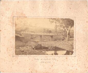
Photograph, c1874 - 1880
A photo of a bluestone and timber bridge across the Deep Creek at Lighthouse Creek. There is a man standing on the bridge. The photographer, Alfred Sinel, is listed in the 1874 rate book.A sepia mounted photograph of a bridge at Lighthouse Gully in Deep Creek.written in ink bottom centre: "Bridge at Lighthouse Gully" / Deep Creek. written LH corner of photograph: Photographed by A. Sinelbridges, sunbury, men, clothing and dress, sinel, alfred, photographers, lighthouse gully, deep creek, shire of bulla, george evans collection -
 Orbost & District Historical Society
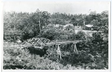
black and white photograph, c1920-1954
This is a copy of "THE BRIDGE AT BOGGY CREEK, NOWA NOWA, LAKE TYERS." which is a Rose Stereograph Co postcard. Boggy Creek Bridge was built in 1916 as part of the Bairnsdale to Orbost extension to the main Gippsland Railway, and is situated in the middle of the township of Nowa Nowa, crossing a steep-sided and well-timbered creek-valley. This section of the line closed in 1987. This bridge plays a major part in the identity and history of the town of Nowa Nowa, This item is associated with the East Gippsland Railway.A large black / white photograph of a large wooden bridge across a creek. There is a house and outbuildings in the background on the right. It is in a bush setting. on back - "Boggy Creek bridge - Nowa Nowa 1887 LaTrobe Collection"boggy-creek-bridge east-gippsland-railway -
 Ringwood and District Historical Society
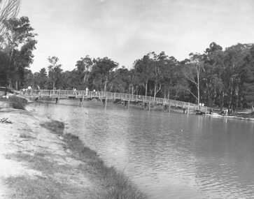
Photograph, Ringwood Lake, 1973 previously Sandy Gully Creek (1854)
Typed below photograph, "Ringwood Lake, 1973 previously Sandy Gully Creek (1854). -
 Ringwood and District Historical Society
Photograph, Ringwood Rifle Range, Jumping Creek Road, South Warrandyte, 1959
Black and white photogaph (3 copies)Written on back of photographs, "Ringwood Rifle Range, Jumping Creek, South Warrandyte, 1959". -
 Ringwood and District Historical Society
Photograph, Looking across Mullum Creek to Adelaide Street. Ringwood 1971
Written on back of photograph, "May 1971. Looking across Mullum Creek to Adelaide Street." -
 Ringwood and District Historical Society
Photograph, The surfaced bypass for Mullum Mullum Creek, Warrandyte Road, Ringwood. Possibly 1987
Written on back of photograph, "Date ? The surfaced bypass for Mullum Mullum Creek, Warrandyte Road." -
 Ringwood and District Historical Society
Photographs, 1979-80 MMBW pipe line project at Hubbard Reserve, North Ringwood � The manhole in the creek
Part of a 43-photo record of the MMBW�s engineering feat in drilling a 12 inch pipe line up to 40 feet deep through rock hardened by volcanic action associated with geological fault that occurs along the line. The work took place from October 1979 to May 1980 on the southern boundary of Hubbard Reserve, North Ringwood. The collection was presented to the Ringwood Historical Research Group by J Clarke on 9th June 1980.E563 1 April 1980 A43 The manhole in the creek, waiting until boring is finished. -
 Stawell Historical Society Inc
Map - Plan, Earle and Partners, Restoration of Pleasant Creek Courthouse Stawell West 1975, 4/8/1975
Designs for Restoration. Includes details for Public Toilet & Trees.A1 Plan of PrecinctDrawing No. 5 4.8.1975. Pleasant Creek Court of Petty Sessions Built in 1860. Museumstawell historical -
 Ringwood and District Historical Society
Photograph, Schwerkolt Cottage, Deep Creek Road, Mitcham - 1964
Black and white photograph- 2 images of front and back entrances of cottage. (2 copies of each image)Written on rear of backing sheet: "Schwerkolt Cottage, Deep Creek Road, Mitcham, 1964." -
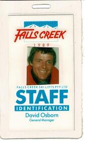 Falls Creek Historical Society
Staff Identification Tag David Osborn 1989
SKI TICKETS Before tows and lifts were introduced at Falls Creek, it could take skiers 20 minutes to climb to the Summit … but only TWO minutes to go back to the bottom. The arrival of tows, then chairlifts and T-bars changed the face of skiing forever. The first rope tow was constructed by Toni St. Elmo for the 1951 winter season. Bob Hymans installed a smaller tow for his guests at Skyline Lodge. Tows were still quite slow, so in 1956 Bob Hymans created his single chairlift. In 1958 the Village rope tow, designed by Albury engineer Jock Wilson, opened. It was financed by shareholders including Bill Griffith (Bowna Ski Club) and the Bridgford family (St. Trinian’s Ski Club). Several other tows followed including the Summit T-bar in 1961, built by Ron McCallum and operated by Alpine Developments Pty. Ltd. which was a company formed by C. H. (Bill) Bridgford. By 1982 Falls Creek was served by 16 different lifts or T-bars, all owned and operated by Alpine Developments (Holdings) Pty. Ltd. During the development of Falls Creek, different methods have been used to pay for the use of tows, lifts and T-bars … including metal tokens, single tickets, strips of tickets and season passes. The Falls Creek Historical Society Collection includes many examples of these items.This Staff Identification Card is significant because it belonged to David Osborn who lead developments at Falls Creek in the late 1980s.A staff identification tag featuring a coloured photograph of David Osborn. He came to Falls Creek to take up the position of General Manager, Falls Creek Ski Lifts Pty. Ltd. He continued in this role until 1990 when he was offered the position of Managing Director at Thredbo. During his period as General Manager major projects carried out at Falls Creek were:- the construction of Halleys Comet Chairlift, Slalom Street Plaza development, the introduction of snowmaking, Cloud 9 Restaurant, the construction of the Scott Chair and the Village Bowl. In 2022 David Osborn released a book, "Falls Creek Stories 1984 - 1990" which documents the developments which occurred in Falls Creek and the people who made them possible.At top: FALLS CREEK 1989 Below photo: FALLS CREEK SKI LIFTS PTY.LTD STAFF IDENTIFICATION David Osborn General Manager chairlift falls creek, david osborn, falls creek development 1980s -
 Falls Creek Historical Society
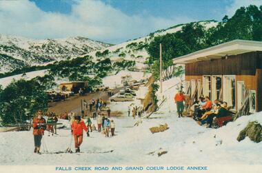
Postcard - Falls Creek Road and Grand Coeur Lodge Annexe
These photographs were taken in and around Falls Creek by Samuel Keith Pearce and printed for him as a foldout postcard by NuColor Vue. The postcards state they were printed for S. K. Pearce Pty. Ltd of Tawonga and Mount Beauty. Samuel Keith Pearce was born on 24 June 1917 in Armadale, Victoria. By the late 1940s he owned the Mt Beauty Supermarket, Newsagency, Drapery and Hardware store at Mount Beauty and also a store at Tawonga in partnership with his brother Gordon Cathew Pearce. For some time, they operated as Pearce Brothers. In the early 1960s Keith also opened a mini mart In Falls Creek. As well as being a keen photographer and an astute businessman, Keith Pearce was a well-known identity in the Kiewa Valley, making many contributions to the development of the area over a long period. This included serving as a member of the Bright Shire Council for many years. He worked hard to promote the interests of the Upper Kiewa Valley. As a sign of recognition and appreciation for his contribution to the community, the park opposite the grocery store in Mount Beauty was named the SK Pearce Gardens in his honour. Samuel Keith Pearce died on 7 July 1994 in Mount Beauty, VictoriaThis collection of postcards and image is significant because they were commissioned by a highly successful business in Falls Creek, Victoria.A high definition photo of Falls Creek Road and Grand Coeur Lodge Annexe. The original Grand Coeur Lodge was built by Bill Hymans between 1950 and 1952. Unfortunately it was burned down in 1961. Grand Coeur was never rebuilt, but Bob modified his annexe to be used as accommodation and later also operated Southern Cross and the Four Seasons. falls creek accommodation, falls creek businesses, grand coeur chalet -
 Upper Yarra Museum
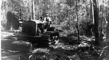
Negative Photographic Reproduction, Bulldozer working at Mc Crae Creek mill 1945
Bulldozer working at Mc Crae Creek mill 1945 Black and White negative scanned at 600 dpibuldozer working mc crae creek mill 1945 -
 Lorne Historical Society
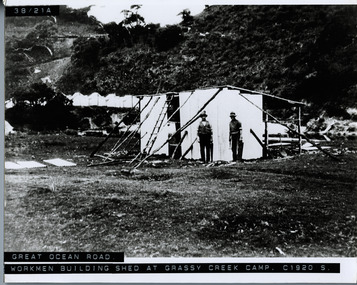
Photograph, Workmen building shed at Grassy Creek Campsite circa 1920
Photograph circa 1920 showing two men using hand tools, building a shed at Grassy Creek -
 Lorne Historical Society
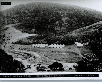
Photograph, Workers tents at Grassy Creek camp Great Ocean road
Photograph showing rows of tens and utility tents at the construction camp at Grassy Creek on the Great Ocean Road -
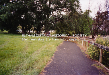
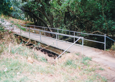 Eltham District Historical Society Inc
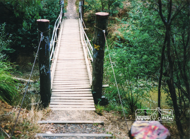
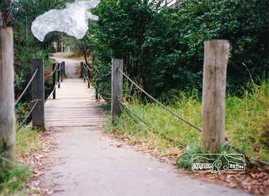
Photograph, Doug Orford, Diamond Creek Trail, Eltham
Two colour photographs showing view looking towards and entering footbridge on the Diamond Creek Trail, Elthamwalkways, bridges, diamond creek, eltham, alistair knox park -
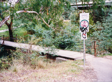 Eltham District Historical Society Inc
Photograph, Doug Orford, Diamond Creek Trail, Eltham
Two colour photographs showing view looking towards and entering footbridge on the Diamond Creek Trail, Elthamwalkways, bridges, diamond creek, eltham -
 Eltham District Historical Society Inc
Photograph, Flooding of Diamond Creek at Lower Eltham Main Road bridge, Nov 2004, 2004
Two colour photographs of the flooded Diamond Creek at the Lower Eltham Main Road bridge in Nov 2004eltham, main road, bridges, diamond creek, floods -
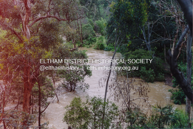
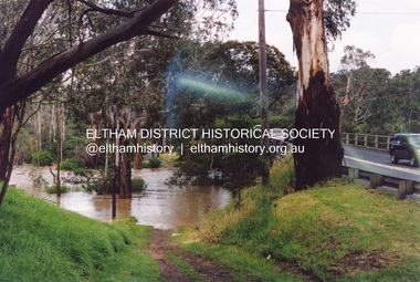
 Eltham District Historical Society Inc
Photograph, Diamond Creek in flood, Eltham, 13 Nov 2004, 13/11/04
Three colour photographs of the floodwater from Diamond Creek crossing the path below the Eltham Community Centre.eltham, diamond creek, floods, eltham community centre -
 Eltham District Historical Society Inc
Photograph, Diamond Creek in flood, Eltham, 13 Nov 2004, 13/11/04
Three colour photographs of the floodwater from Diamond Creek crossing the path below the Eltham Community Centre.eltham, diamond creek, floods, eltham community centre -
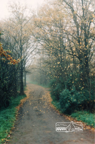 Eltham District Historical Society Inc
Photograph, Diamond Creek Trail, Eltham
Colour photograph of Autumn view of Diamond Creek Trail opposite Dalton Street west of Main Roaddalton street, walkways -
 Eltham District Historical Society Inc
Photograph, Flooding of Diamond Creek at Lower Eltham Main Road bridge, Nov 2004, 2004
Two colour photographs of the flooded Diamond Creek at the Lower Eltham Main Road bridge in Nov 2004eltham, main road, bridges, diamond creek, floods -
 Eltham District Historical Society Inc
Photograph, Diamond Creek in flood, Eltham, 13 Nov 2004, 13/11/04
Three colour photographs of the floodwater from Diamond Creek crossing the path below the Eltham Community Centre.eltham, diamond creek, floods, eltham community centre -
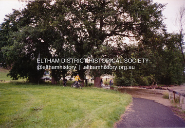
 Eltham District Historical Society Inc
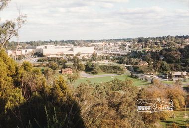
Photograph, Diamond Creek Valley, Eltham
Colour photograph looking north over the Diamond Creek Valley from the area of the Living and Learning Centre.eltham, diamond creek valley -
 Eltham District Historical Society Inc
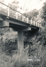
Photograph, Watsons Creek Bridge, Christmas Hills, 1970c
Black and white photograph of bridge over Watsons Creek, Christmas Hills (Clintons Road?) c.1970bridges, watsons creek, christmas hills -
 Eltham District Historical Society Inc
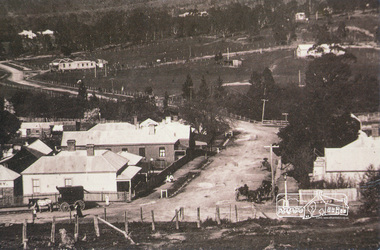
Photograph, Chute Street, Diamond Creek, 1910, looking east, 1910
Postcard of Chute Street Diamond Creek looking east, 1910 from the collection of Nillumbik Historical Society.diamond creek, chute street -
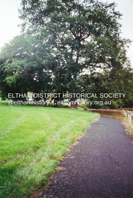
 Eltham District Historical Society Inc
Photograph, Doug Orford, Diamond Creek Trail, Eltham
Two colour photographs showing view looking towards and entering footbridge on the Diamond Creek Trail, Elthamwalkways, bridges, diamond creek, eltham, alistair knox park -
 Eltham District Historical Society Inc
Photograph, Doug Orford, Diamond Creek Trail, Eltham
Two colour photographs showing view looking towards and entering footbridge on the Diamond Creek Trail, Elthamwalkways, bridges, diamond creek, eltham -
 Stawell Historical Society Inc
Slide, Ian McCann, Pleasant Creek c 1972
Two Glass fronted buildings with green painted brick building in background Pleast Creek c 1972stawell buildings -
Whitehorse Historical Society Inc.
Photograph - Illustration, Stephen Creek, n.d
Photo of Stephen Creek,1836 - 1908, early land holder who arrived in box Hill in 1856.Photo of Stephen Creek,1836 - 1908, early land holder who arrived in box Hill in 1856.Photo of Stephen Creek,1836 - 1908, early land holder who arrived in box Hill in 1856.creek, stephen, pioneers -
 Whitehorse Historical Society Inc.
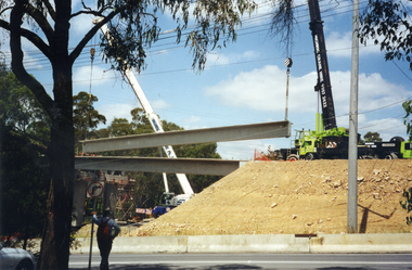
Photograph, Bridge Work Deep Creek Road, 1/02/2002 12:00:00 AM
Coloured Photo of last Span being put into place on Bridge over Deep Creek Road, Mitcham.deep creek road, mitcham.