Showing 4068 items matching "surveying"
-
 Ringwood and District Historical Society
Document - Map, Plan of Subdivision - Part of Crown Allotments 14A & 14C, Parish of Ringwood, County of Mornington, Vol 5378 Fol 511 - 1927
Department of Lands and Survey photocopy dated 17/1/1951, page number 12308.Map includes Canterbury Road, Heathmont Road, Dickasons Road, Bennett Avenue, Orchid Street and Allens Road, Heathmont, Vic. -
 Bendigo Historical Society Inc.
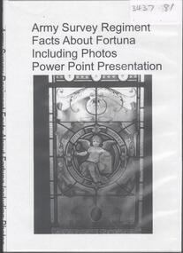
Archive - ARMY SURVEY REGIMENT
DVD. Army Survey Regisment, facts about Fortuna, including photos, Powerpoint presentation. -
 Orbost & District Historical Society
Book - front cover, The Corringle Creek to Sydenham Inlet Coastal Reserve A RESOURCES STUDY, 1977
This 1977 Resources Study was a joint project of the Shire of Orbost & the Dept. of Crown Lands & Survey with the purpose of collating information on natural resources, pattern of public use, and constraints on future use so that management can be formulated.This report gives and understanding of the resources and management directions of coastal land in East Gippsland in 1977. A buff coloured cover with black printing and blue tape binding. 71 pages + maps/charts. THE CORRINGLE CREEK TO SYDENHAM INLET COASTAL RESERVE. A resources study with comment on the implications for management by IAN R. BROWN Research officer and PETER B. LAVERY Land Management Oficer. Coastal management Committee Victoria 1977. Published under the authority of the Coastal Management Committee by the Department of Crown Lands and Survey, Victoria 1977. Printed by James Yeates Printing, Bairnsdale 3875.corringle creek, sydenham inlet, natural resources survey -
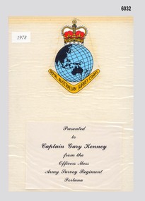 Bendigo Military Museum
Album - Photo Album presented to Capt GW Kenney by members of the ASR Officers Mess on leaving Fortuna 1978, 1978
Images of the contents of a Photo Album presented to Capt GW Kenney by members of the ASR Officers Mess on leaving Army Survey Regiment, Fortuna in 1978 are particularly important as a snapshot set of many members of the Army Survey Regiment in 1978. These photos are particularly interesting as members are photographed in their workplaces. Unfortunately, not all workplaces have been represented, however a large number have been. The majority of individuals in these photographs who were serving at the Army Survey Regiment at the time have been named. The images have been converted into MPEG - 4 video file format that runs for 3.5 minutes and is stored on a memory stick. The 69 individual still images have been saved in compressed JPEG (.jpg) format and are also stored on the single 16Gb USB memory stick. 39156 Capt GW Kenney served in the Australian Army from 6 Jan 67 till 1 Aug 2000. He commenced his career within the RASvy Corps until 1978 and after completing his religious training went on to serve as an Army Chaplin for the remainder of his 30yr Army career. He officiated at many significant Survey Corps ceremonial and social occasions in his Chaplin capacity. Capt Kenney gave his permission for the scanning of the Album by the ExFortuna Survey Association Inc.Images of the contents of a Photo Album presented to Capt GW Kenney by members of the ASR Officers Mess on leaving Army Survey Regiment, Fortuna in 1978. Images are 300 dpi scans of the colour and black and white photographs from the Album. The 69 images are mainly colour with a few being black and white. The individual still images have been saved in compressed JPEG (.jpg) format and stored on a single 16Gb USB memory stick. The images have also been converted into MPEG - 4 video file format and also stored on the memory stick. The 10.7Mb video runs for 3.5 minutes. A hard copy colour print of the Album cover is included.royal australian survey corps, rasvy, fortuna, army survey regiment, army svy regt, asr -
 Marysville & District Historical Society
Map (Item) - Tourist Map, Tourists Resorts' Committee, Tourist's Map of Healesville Marysville and Warburton Districts, 13.10.1925
A tourist map for Healesville, Marysville and Warburton that was produced by the Tourists Resorts' Committee. This map was produced in 1925.A tourist map for Healesville, Marysville and Warburton that was produced by the Tourists Resorts' Committee.Photo Lithographed at the Department of Lands and Survey, Melbourne by W.J. Butson./ 13.10.25healesville, marysville, warburton, victoria, tourists resorts' committee, ben cairn, mount donna buang, the black's spur, the acheron valley, narbethong, launching place, tourist information, tourism, map, tourist map -
 Bendigo Historical Society Inc.
Map - JACK FLYNN COLLECTION: VILLAGE OF BETLEY, 30/06/1874
Map: Village of Betley, on the Bet Bet Creek, Parish of Dunolly. Parish plan.Photo Lithographed at the Department of Lands and Survey Melbourne by J. Noone 30.6.74map, gladstone, village, betley, bet bet creek, dunolly -
 Bendigo Historical Society Inc.
Map - JACK FLYNN COLLECTION: BAMAWM, 19/08/1924
Map: Parish of Bamawm, County of Bendigo. Parish plan.Photo Lithographed at the Department of Lands and Survey, Melbourne by W.J. Butson. 19.8.24map, bendigo, parish plan, bamawm -
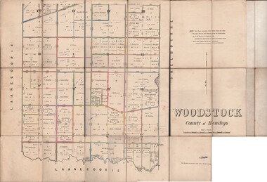 Bendigo Historical Society Inc.
Map - JACK FLYNN COLLECTION: WOODSTOCK, 27/03/75
Map: Parish of Woodstock , County of Bendigo. Parish plan.Photo-Lithographed at the Department of Lands and Survey Melbourne by J. Noone. 27.3.79map, bendigo, parish plan, woodstock -
 Stawell Historical Society Inc
Map, T.F. McGauran, William Couty of Borong 1891, 1891
Stawell Water Supply Reserve. Grampians State Forest. Dairy Creek, Fyans Creek, Barney's Creek, Bovine Creek, Glasstree Creek, Stoney Creek. Stawell Water Supply Aquaduct Fkuming Tunnel.A2 Parish Map of Willam Inculdin Stawell Water Supply Reserve and Creeks. Marked in redPhoto Lithographed at the Department of Lands and Survey Melbourne. By T.F. McGauran 20.07.91 water supply survey -
Stawell Historical Society Inc
Map, T.F. McGauran, Winjallock County of Kara Kara, 1900
Noth of Navarre and BarkleyA2 Map0f Parish of Kara Kara.Photo Lithographed and the department of Lands & Survey, Melbourne by T.F. McCauran 22.10.00survey -
Stawell Historical Society Inc
Map, Department of Lands and Survey, Borough of Stawell. Parishes of Stawell and Illawarra 1903, 1903
Victoria Co., St Georges Co., Wimerra Co., Leviathon Co. Tramway, Quarry reserve, Newington Co., Galatea Co., Moonlight Co., Federal Co., Borough reservior., A0 Map of Stawell on linen backing. Plus one Printed on PaperPhoto Lithograped at the Department of Lands and survey Melbourne by T.F. McGauran 13.6.03surevy -
 Bacchus Marsh & District Historical Society
Map, Parwan Parish Map, County of Grant, 1909
A single page paper map showing the map for the Parish of Parwan in the County of Grant. A cadastral map showing parish boundaries and land ownership. The map is pasted into a bound volume containing 76 maps or plans in total. High resolution digital image stored on BMDHS computer network. Photo-lithographed at the Department of Lands and Survey, Melbourne by T.F. McGauran, 7.7.09. bacchus marsh region parish plans, parwan parish maps, parwan parish plan -
 Bacchus Marsh & District Historical Society
Map, Trentham Parish Map 1905 Copy 1
A single page paper map showing the map for the Parish of Trentham in the Counties of Dalhousie and Bourke. A cadastral map showing parish boundaries and land ownership. The map is pasted into a bound volume containing 76 maps or plans in total. High resolution digital image stored on BMDHS computer network. Photo-lithographed at the Department of Lands and Survey, Melbourne by T.F. McGauran 22.3.05 trentham parish maps, trentham parish plan, bacchus marsh region parish plans -
 Bacchus Marsh & District Historical Society
Map, Blackwood Parish Map, County of Bourke, 1892
A single page paper map showing the map for the Parish of Blackwood in the County of Bourke. A cadastral map showing parish boundaries and land ownership. The map is pasted into a bound volume containing 76 maps or plans in total. High resolution digital image stored on BMDHS computer network. Photo-lithographed at the Department of Lands and Survey, Melbourne by T.F. McGauran 14.7.92bacchus marsh region parish plans, blackwood parish plan, blackwood parish maps -
 Bacchus Marsh & District Historical Society
Map, Blackwood Parish Map, County of Bourke, 1905
A single page paper map showing the map for the Parish of Blackwood in the County of Bourke. A cadastral map showing parish boundaries and land ownership. The map is pasted into a bound volume containing 76 maps or plans in total. High resolution digital image stored on BMDHS computer network. Photo-lithographed at the Department of Lands and Survey, Melbourne by T.F. McGauran 21.7.05bacchus marsh region parish plans, blackwood parish plan, blackwood parish maps -
 Bacchus Marsh & District Historical Society
Map, Myrniong Parish Map, County of Bourke, 1882
A single page paper map showing the map for the Parish of Myrniong in the County of Bourke. A cadastral map showing parish boundaries and land ownership. The map is pasted into a bound volume containing 76 maps or plans in total. High resolution digital image stored on BMDHS computer network. Photo-lithographed at the Department of Lands and Survey, Melbourne by J. Noone, 17.7.82myrniong parish plan, myrniong parish maps, bacchus marsh region parish plans -
 Bacchus Marsh & District Historical Society
Map, Parish of Yangardook, County of Bourke 1876
The parish of Yangardook lies directly north of the township of Melton. The locality of Toolern Vale lies in the centre of this parish. A single page paper map showing the plan for the Parish of Yangardook in the in the County of Bourke. Scale 40 chains to 1 inch. The map is pasted into a bound volume containing 76 maps or plans in total. High resolution digital image stored on BMDHS computer network. Photo lithographed at the Department of Lands and Survey, Melbourne by J. Noone, 1.8.76yangardook parish maps, toolern vale victoria maps -
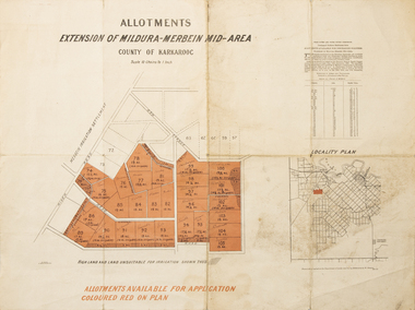 Merbein District Historical Society
Map - Allotments Extension of Mildura-Merbein Mid-Area, Allotments available, 23 November 1920
Allotments available to Discharged Soldiers Discharged Soldier's Settlement Act Historic Large map, folded in 4, coloured map of Merbein indicating allotments available and locality plan. Scale 10 chain to 1 inchPhoto-Lithographed at Department of lands Survey, Melbourne J. Butson 23.11.20discharged soldiers, ww1, soldier settlement, irrigation -
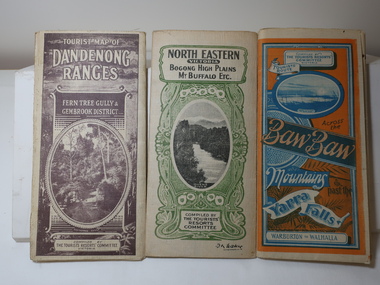 Kiewa Valley Historical Society
Maps - Tourist
These maps were all dated 1933 which was before the construction of the Kiewa Hydro Electric Scheme and when Tawonga was spelt Towonga. North East Victoria in 1933 was before the construction of the Kiewa Hydro Electric Scheme so the townships of Mt Beauty and Bogong are not shown. The description of the Snow Lines was important as skiers, bushwalkers and campers relied on them. The details on the map include "ADB. Numbered from A.1-377 round plates. CD Numbered from C 1-235 square plates. Poles about 3 chains apart 27 to the mile." 3 Tourist location maps (folded) and printed on parchment. 1. Tourist map of the Dandenong Ranges. Brown cover. dated 6-4-33. Govt. printer showing roads, tracks in red and heights of the land. 2. Tourist Map of Warburton, Mt Baw Baw, and Walhalla. Blue and Orange cover. dated 23-5-33 Govt. printer. 3 different maps of each area showin roads, tracks and timber tramways.Also in red and blue. 3. Tourist Map of North Eastern Victoria including Bogong High Plains Mt Buffalo Etc. Green cover. dated June 1933 Govt. printer. Main map and insert titled Bogong High Plains. Showing roads , tracks and tram ways. On insert showing snow poles. Also Red and Blue and mountains.By Authority of H.J. Green - 6 pence. Dept of Lands and Survey, Melbourne1933 maps, tourism maps, bogong high plains map 1933, snow poles -
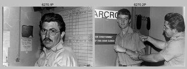 Bendigo Military Museum
Photograph - Photo Troop, Lithographic Squadron – Army Survey Regiment, Fortuna, Bendigo, c1983
This collection of seven photos was most likely taken at Lithographic Squadron, Army Survey Regiment, Fortuna, Bendigo in c1983. The main tasks undertaken by technicians in Photo Troop were most likely enlargements, reductions and duplication of map reproduction material, and processing of aerial photography.This is a set of seven photographs of Photo Troop personnel and equipment from Lithographic Squadron at the Army Survey Regiment, Fortuna, Bendigo, c1983. The photographs were on 35mm negative film and were scanned at 96 dpi. They are part of the Army Survey Regiment’s Collection. .1) - Photo, black & white, c1983, Photo Troop work area, SGT Garran Hill. .2) - Photo, black & white, c1983, Photo Troop work area, L to R: SPR Steve Burke, SGT Garran Hill. .3) - Photo, black & white, c1983, Photo Troop work area, SPR Steve Burke. .4) - Photo, black & white, c1983, Photo Troop work area, WO1 Noel ‘Nesty’ Coulthard. .5) - Photo, black & white, c1983, Photo Troop work area, WO1 Noel ‘Nesty’ Coulthard. .6) - Photo, black & white, c1983, Photo Troop work area, CPL Gary Tremain. .7) - Photo, black & white, c1983, Photo Troop work area, CPL Neville Carr. No personnel are identified.royal australian survey corps, rasvy, army survey regiment, army svy regt, fortuna, asr, litho -
 Bendigo Military Museum
Photograph - Komori Newkoni Printing Press operating at the Army Survey Regiment, c1980s
These five photographs of the Komori Newkoni Printing Press were probably taken circa 1980s in Lithographic Squadron at the Army Survey Regiment, Fortuna, Bendigo. The photos are not annotated except for .4P. The Komori Newkoni Printing Press was a four-colour offset press. It was one of the replacements for the George Mann Printing Presses, however improvements to productivity were not realised as it was unreliable, was very cramped between decks and there were safety concerns for the operators. This lithographic printing machine built by Komori Printing Machinery Co., Ltd in Japan. The press was in service at the Army Svy Regt from 1975 to the 1980s.This is a set of photographs of the Newkoni Komori Printing Press operational at the Army Survey Regiment, Bendigo c1980s. The photographs were printed on photographic paper and are part of the Army Survey Regiment’s Collection. The photographs were scanned at 300 dpi. .1) - Photo, black & white, c1980s, Terry Winzar, Lithographic Squadron .2) - Photo, black & white, c1980s, Roy Hicks, Lithographic Squadron .3) - Photo, black & white, c1980s, L to R: unidentified, Kim Reynolds, unidentified (x3), John ‘Flash’ Anderson, Lithographic Squadron .4) - Photo, black & white, c1980s, Per Andersen, Lithographic Squadron .5) - Photo, black & white, c1980s, John ‘Flash’ Anderson, Lithographic SquadronInscriptions and markings .1 to .5 – no annotationsroyal australian survey corps, rasvy, army survey regiment, army svy regt, fortuna, asr, printing, litho -
 Bendigo Historical Society Inc.
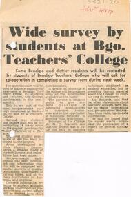
Document - LA TROBE UNIVERSITY BENDIGO COLLECTION: BENDIGO TEACHERS' COLLEGE SURVEY
A Bendigo Advertiser article titled 'Wide survey by students at Bgo. Teachers' College'. Some Bendigo and district residents to be contacted by students of Bendigo Teachers' College to complete a survey. The aim of the questionnaire is to indicate the extent of the community's awareness of the college and students' involvement in the local community. The Principal of the College Mr. K.G. Scarrott made a statement regarding the purpose and value of the survey. Bendigo Advertiser 14/8/1971.bendigo, education, bendigo teachers' college survey, la trobe university bendigo collection, collection, bendigo, education, survey, questionnaire, bendigo teachers' college, mr. k.g. scarrott, bendigo advertiser, tertiary education, teacher training, students -
 Bendigo Historical Society Inc.
Document - LANDS OFFICE - CROWN LANDS SURVEYED AND SOLD SANDHURST - 1857 - 1879, 1857 - 1879
Journal: black hard cover with buff spine and corners. Contains details of crown land surveyed and sold, district of Sandhurst. Double pages numbered on top right, page columns - parish, town lands, particulars, survey fees, date of survey, date of sale, auction, selection price per acre, total amount, purchaser. No index. On spine '08' 'Bendigo A' 26th June 1857 to 1879 (?)Lands Officeplace, land sales, lands office, crown land, land surveys, bendigo, sandhurst -
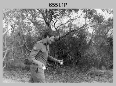 Bendigo Military Museum
Photograph - 4th Field Survey Squadron Regimental Training, Murray Bridge Training Area, SA, 1988
This is a set of eight photographs of 4th Field Survey Squadron personnel undergoing regimental training held at the Murray Bridge Training Area of South Australia in 1988. The aim of regimental training was typically to provide personnel a practical knowledge of infantry and minor tactics at the section level, navigation and map reading, RATEL and survival in the Field.This is a set of eight photographs of 4th Field Survey Squadron personnel undergoing regimental training held at the Murray Bridge Training Area of South Australia in 1988. The black and white photographs are on 35mm negative film and are part of the Army Survey Regiment’s Collection. The photographs were scanned at 96 dpi. .1) - Photo, black & white, 1988. CPL Steve McGuiness. .2) - Photo, black & white, 1988. L to R: Unidentified, SPR Charmian McKean. .3) - Photo, black & white, 1988. SPR Andrew Quin. .4) - Photo, black & white, 1988. L to R: Unidentified, LT Geoff ‘GT’ Ford. .5) & .6) - Photo, black & white, 1988. Unidentified personnel. .7) - Photo, black & white, 1988. L to R: Unidentified (x2), SPR Perry Langeberg, SGT Laurie Justin (3rd from right), remainder unidentified. .8) - Photo, black & white, 1988. L to R: Unidentified, SGT Laurie Justin, remainder unidentified..1P to .8P – There are no personnel identified. ‘1988 REGT ADV TRAINING MURRAY BRIDGE’ annotated on negatives sleeve.royal australian survey corps, rasvy, 4 fd svy sqn -
 Federation University Historical Collection
Book, Report on the Ballarat East Gold-Field, 1894 and Ballarat East Gold-Field, 1907, 1894
The Ballarat Ironworkers' and Polytechnic Association was at the Ballarat School of Mines. In 1907 J.W. Gregory Professor of Geology at Glasgow Univesity, Late Director of the geological Survey of Victoria and Professor of Geology at Melbourne University. W. Dickson was Secretary for Mines and Donald McLeod was the Minister of Mines. in 1894 Ernest Lidgey was the Assistant Geological Surveyor for the Victorian Department of Mines. A.W. Howitt was Secretary for Mines and Henry Foster was the Minister of Mines. Charcoal hard covered report on the Ballarat East Goldfield. The book combines two reports from the Victorian Department of Mines. The 1894 report is 52 pages and includes images and plans. The 1907 Report is number 4 in the Memoirs of the Geological Survey of Victoria. Photographs include Looking South from the Britannia Mullock Heap, View from Sovereign Hill, Golden Point gold discovery site.Stamped "Ballarat Ironworkers' Association School of Mines" Bookplate of the Ballarat Ironworkers' and Polytechnic Association. Written inside front cover: "S.J. Miller, 115 Ascot Street, Ballarat"ballarat ironworkers' and polytechnic association, ballarat school of mines, ironworkers, geology, mining, ballarat east, llanberris, victoria united mine, normanby, north woah hawp, bookplate, s.j. miller, library plate, golden point, gold discovery at golden point, new normanby mine, william baragwanath, new speedwell, britannia united, llanberris co, sulieman pasha, prince regent, dalzell-cum-prince regent, north prince extended, eastern star, f. gray, victoria united gold mine, sovereign hill mine, prince regent mine, britannia mine -
Whitehorse Historical Society Inc.
Map, Dandenong Ranges area. Sheet 7, c1957
Detailed map covering area from Mitcham and Vermont to Ringwood and Heathmont.Detailed map covering area from Mitcham and Vermont to Ringwood and Heathmont. Shows streets, block boundaries, buildings, railway and creeks. Note says prepared from State Aerial Survey, April 1954 and Cadastrial Survey information July 1956.Detailed map covering area from Mitcham and Vermont to Ringwood and Heathmont. maps, mitcham, vermont, ringwood, heathmont -
 Bendigo Historical Society Inc.
Map - FORTUNA HUSTLER'S MINE - PLAN OF THE FORTUNA HUSTLER'S MINE
Plan of the Fortuna Hustler's Mine, Bulletin No 33, Plate No II. Geological Survey of Victoria. Signed by H A Whitelaw, Underground Survey Office Bendigo, September 1913. Map shows levels and depths. There are smaller drawings of some sections of some levels. mining, parish map, fortuna hustler's mine, plan of the fortuna hustler's mine, geological survey of victoria, h a whitelaw, underground survey office bendigo -
 Bendigo Military Museum
Photograph - Printer Technicians and other RASvy personnel at the Army Survey Regiment, c1980s
These ten photographs were probably taken circa 1980s in Lithographic Squadron at the Army Survey Regiment, Fortuna, Bendigo. Most of the photos were taken on the shop floor in the Print Room.This is a set of photographs of Printer Technicians and other RASvy personnel in Lithographic Squadron, Army Survey Regiment, Bendigo c1980s. The photographs were printed on photographic paper and are part of the Army Survey Regiment’s Collection. The photographs were scanned at 300 dpi. .1) - Photo, black & white, c1980s, WO2 Steve Egan, Lithographic Squadron .2) - Photo, black & white, c1980s, WO2 Jeff Lynch, Lithographic Squadron .3) - Photo, colour, c1980s, SPR Peter Dillon, Lithographic Squadron .4) - Photo, black & white, c1980s, L to R: Peter Dillon, unidentified, Lithographic Squadron .5) - Photo, black & white, c1980s, L to R: SPR Colin Yeats, SPR Graeme Spong, CPL Peter Dillon, Lithographic Squadron .6) - Photo, black & white, c1980s, L to R: SPR Colin Yeats, WO2 Ralph Chant, Lithographic Squadron .7) - Photo, black & white, c1980s, L to R: Dale Hudson, Mark ‘Dogs’ Doherty, Lithographic Squadron .8) - Photo, black & white, c1980s, L to R: SGT Greg Rowe, WO1 Trevor Osborne, Dale Hudson, Lithographic Squadron .9) - Photo, black & white, c1980s, L to R: unidentified, SGT Kim Reynolds, Shane ‘Soupy’ Campbell, Lithographic Squadron .10) - Photo, colour, 1987, L to R: Jim Ash, Daryl South, Jeff Willey, unidentified, Lithographic Squadron.1P to .4P – not annotated .5P - annotated on front with ‘I AM BROKE, I’M NOT and me neither’, annotated on back with ‘Curly Larry Moe’ .6P to .9P – not annotated .10P – annotated with dateroyal australian survey corps, rasvy, army survey regiment, army svy regt, fortuna, asr, litho, printing -
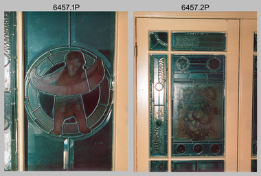 Bendigo Military Museum
Photograph - Army Survey Regiment - Fortuna Interior, Bendigo, c1985
This set of 22 photographs was taken inside Army Survey Regiment’s Fortuna Villa circa 1985. The photos feature some of Fortuna Villa’s interior. Unfortunately, the magnificent array of colours and hand-painted features of Fortuna’s leadlight windows are not highlighted with light transmission, as the photographer did not take the photos in the daytime. See item 6456.30P, for photos of Fortuna Villa’s exterior and The Army Survey Regiment’s out-buildings that were taken at the same time.This set of 22 photographs was taken inside Army Survey Regiment’s Fortuna Villa circa 1985. The colour photographs were printed on photographic paper and are part of the Army Survey Regiment’s Collection. The photographs were scanned at 300 dpi. .1) & .2) - Photo, colour, c1985. Fortuna Villa – Reception/Music Room leadlight windows. .3) - Photo, colour, c1985. Fortuna Villa – Entrance foyer door and leadlight windows. .4) - Photo, colour, c1985. Fortuna Villa – Entrance foyer vaulted ceiling. .5) - Photo, colour, c1985. Fortuna Villa – Dressing Room bay leadlight windows. .6) - Photo, colour, c1985. Fortuna Villa – Dressing Room wood panel wardrobe (concealed marble bath inside). .7) - Photo, colour, c1985. Fortuna Villa – Main bathroom’s solid cedar toilet chest and water pitcher set. .8) to .14) - Photo, colour, c1985. Fortuna Villa – Drawing Room bay leadlight windows. .15) to .16) - Photo, colour, c1985. Fortuna Villa – Cupola stairway leadlight windows. .17) - Photo, colour, c1985. Fortuna Villa – Dining/ballroom doorway with velvet wallpaper. .18) - Photo, colour, c1985. Fortuna Villa – Dining/ballroom. .19) - Photo, colour, c1985. Fortuna Villa – Billiard room’s timber vaulted ceiling. .20) & .21) - Photo, colour, c1985. Fortuna Villa – Top floor nursery samples of original wallpaper. .22) - Photo, colour, c1985. Fortuna Villa – Top floor ballroom/gymnasium’s elaborate vaulted ceiling.There are brief descriptions on a note behind each photograph.royal australian survey corps, rasvy, army survey regiment, army svy regt, fortuna, asr