Showing 2020 items matching "the place between"
-
 Eltham District Historical Society Inc
Photograph, Hurstbridge-Kinglake Road, 1 April 1905
Country Roads Board, Neg. No. 18.3This photo forms part of a collection of photographs gathered by the Shire of Eltham for their centenary project book,"Pioneers and Painters: 100 years of the Shire of Eltham" by Alan Marshall (1971). The collection of over 500 images is held in partnership between Eltham District Historical Society and Yarra Plenty Regional Library (Eltham Library) and is now formally known as the 'The Shire of Eltham Pioneers Photograph Collection.' It is significant in being the first community sourced collection representing the places and people of the Shire's first one hundred years.Digital imagesepp, shire of eltham pioneers photograph collection, kinglake, hurstbridge-kinglake road -
 Eltham District Historical Society Inc
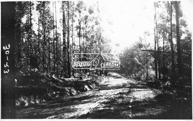
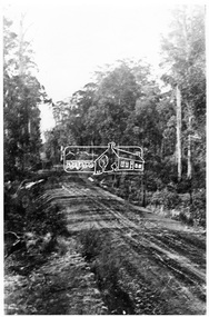
Photograph, Kinglake Road, 13 April 1905
Source: Country Roads Board, Neg. No. 30-23This photo forms part of a collection of photographs gathered by the Shire of Eltham for their centenary project book,"Pioneers and Painters: 100 years of the Shire of Eltham" by Alan Marshall (1971). The collection of over 500 images is held in partnership between Eltham District Historical Society and Yarra Plenty Regional Library (Eltham Library) and is now formally known as the 'The Shire of Eltham Pioneers Photograph Collection.' It is significant in being the first community sourced collection representing the places and people of the Shire's first one hundred years.Digital imagesepp, shire of eltham pioneers photograph collection, kinglake, hurstbridge-kinglake road -
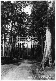
 Eltham District Historical Society Inc
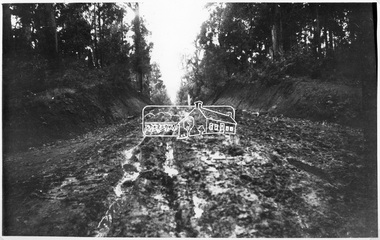
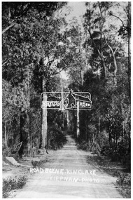
Photograph, Whittlesea-Kinglake Road near "Tommy's Hut", 13 April 1905
Country Roads Board, Neg. No. 30-25This photo forms part of a collection of photographs gathered by the Shire of Eltham for their centenary project book,"Pioneers and Painters: 100 years of the Shire of Eltham" by Alan Marshall (1971). The collection of over 500 images is held in partnership between Eltham District Historical Society and Yarra Plenty Regional Library (Eltham Library) and is now formally known as the 'The Shire of Eltham Pioneers Photograph Collection.' It is significant in being the first community sourced collection representing the places and people of the Shire's first one hundred years.Digital imagesepp, shire of eltham pioneers photograph collection, kinglake, whittlesea-kinglake road -
 Eltham District Historical Society Inc
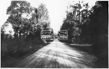
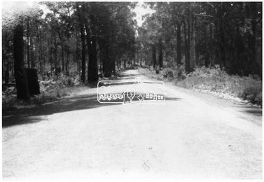
Photograph, Kinglake Road
Country Roads Board, Neg. No. 30-24This photo forms part of a collection of photographs gathered by the Shire of Eltham for their centenary project book,"Pioneers and Painters: 100 years of the Shire of Eltham" by Alan Marshall (1971). The collection of over 500 images is held in partnership between Eltham District Historical Society and Yarra Plenty Regional Library (Eltham Library) and is now formally known as the 'The Shire of Eltham Pioneers Photograph Collection.' It is significant in being the first community sourced collection representing the places and people of the Shire's first one hundred years.Digital imagesepp, shire of eltham pioneers photograph collection, kinglake, kinglake road -
 Eltham District Historical Society Inc
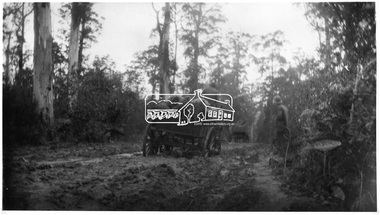
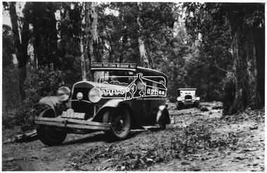
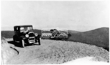
Photograph, Goodwood Powelltown Melbourne Daily
Two cars, probably 1929 Chryslers navigate the forest track probably Kinglake National Park. Front vehicle has sign: "Goodwood Powelltown Melbourne daily". Photo sourced from the Forests Commission of Victoria. Ref. JJ 399This photo forms part of a collection of photographs gathered by the Shire of Eltham for their centenary project book,"Pioneers and Painters: 100 years of the Shire of Eltham" by Alan Marshall (1971). The collection of over 500 images is held in partnership between Eltham District Historical Society and Yarra Plenty Regional Library (Eltham Library) and is now formally known as the 'The Shire of Eltham Pioneers Photograph Collection.' It is significant in being the first community sourced collection representing the places and people of the Shire's first one hundred years.Digital imagesepp, shire of eltham pioneers photograph collection, kinglake, goodwood powelltown melbourne daily, automobile, chrysler, kinglake national park, forest track -
 Eltham District Historical Society Inc
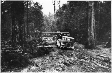
Photograph, Goodwood Powelltown Melbourne Daily rear view
Two vehicles, possibly 1929 Chryslers negotiate a forest track, probably in the Kinglake National Park. Front vehicle has sign: Goodwood Powelltown Melbourne daily". Source: Forests Commission of Victoria. Ref. JJ 397This photo forms part of a collection of photographs gathered by the Shire of Eltham for their centenary project book,"Pioneers and Painters: 100 years of the Shire of Eltham" by Alan Marshall (1971). The collection of over 500 images is held in partnership between Eltham District Historical Society and Yarra Plenty Regional Library (Eltham Library) and is now formally known as the 'The Shire of Eltham Pioneers Photograph Collection.' It is significant in being the first community sourced collection representing the places and people of the Shire's first one hundred years.Digital imagesepp, shire of eltham pioneers photograph collection, kinglake, goodwood powelltown melbourne daily, automobile, forest track, chrysler, kinglake national park -
 Eltham District Historical Society Inc
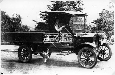
Photograph, Forests Commission automobile, 26 December 1895
Source: Forests Commission of Victoria. Ref. HH 988This photo forms part of a collection of photographs gathered by the Shire of Eltham for their centenary project book,"Pioneers and Painters: 100 years of the Shire of Eltham" by Alan Marshall (1971). The collection of over 500 images is held in partnership between Eltham District Historical Society and Yarra Plenty Regional Library (Eltham Library) and is now formally known as the 'The Shire of Eltham Pioneers Photograph Collection.' It is significant in being the first community sourced collection representing the places and people of the Shire's first one hundred years.Digital imagesepp, shire of eltham pioneers photograph collection, kinglake, automobile, forrests commision -
 Eltham District Historical Society Inc
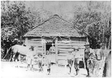
Negative - Photograph, Mr. Glower, Caretaker Cottage on Aitken's property
Reproduced on p42 of 'Pioneers & Painters'This photo forms part of a collection of photographs gathered by the Shire of Eltham for their centenary project book,"Pioneers and Painters: 100 years of the Shire of Eltham" by Alan Marshall (1971). The collection of over 500 images is held in partnership between Eltham District Historical Society and Yarra Plenty Regional Library (Eltham Library) and is now formally known as the 'The Shire of Eltham Pioneers Photograph Collection.' It is significant in being the first community sourced collection representing the places and people of the Shire's first one hundred years.Digital image 4 x 5 inch B&W Neg B&W Print 19 x 25 cmsepp, shire of eltham pioneers photograph collection, kinglake, aitken, caretaker cottage, glower, pioneers and painters -
 Eltham District Historical Society Inc
Photograph, Bald Spur Look-out
Source: Mrs. McMinn, KinglakeThis photo forms part of a collection of photographs gathered by the Shire of Eltham for their centenary project book,"Pioneers and Painters: 100 years of the Shire of Eltham" by Alan Marshall (1971). The collection of over 500 images is held in partnership between Eltham District Historical Society and Yarra Plenty Regional Library (Eltham Library) and is now formally known as the 'The Shire of Eltham Pioneers Photograph Collection.' It is significant in being the first community sourced collection representing the places and people of the Shire's first one hundred years.Digital imagesepp, shire of eltham pioneers photograph collection, kinglake, bald spur look-out -
 Eltham District Historical Society Inc
Photograph, The new Glenburn Road, Kinglake
Source: Mrs. McMinn, Kinglake Cross Ref: SEPP_0034This photo forms part of a collection of photographs gathered by the Shire of Eltham for their centenary project book,"Pioneers and Painters: 100 years of the Shire of Eltham" by Alan Marshall (1971). The collection of over 500 images is held in partnership between Eltham District Historical Society and Yarra Plenty Regional Library (Eltham Library) and is now formally known as the 'The Shire of Eltham Pioneers Photograph Collection.' It is significant in being the first community sourced collection representing the places and people of the Shire's first one hundred years.Digital imagesepp, shire of eltham pioneers photograph collection, kinglake, glenburn road -
 Eltham District Historical Society Inc
Photograph, Road from Hotel to Hall, Kinglake
Source: Mrs. McMinn, Kinglake Cross Ref: SEPP_0037This photo forms part of a collection of photographs gathered by the Shire of Eltham for their centenary project book,"Pioneers and Painters: 100 years of the Shire of Eltham" by Alan Marshall (1971). The collection of over 500 images is held in partnership between Eltham District Historical Society and Yarra Plenty Regional Library (Eltham Library) and is now formally known as the 'The Shire of Eltham Pioneers Photograph Collection.' It is significant in being the first community sourced collection representing the places and people of the Shire's first one hundred years.Digital imagesepp, shire of eltham pioneers photograph collection, kinglake -
 Eltham District Historical Society Inc
Photograph, Road from Hotel to Hall, Kinglake at later stage
Source: Mrs. McMinn, Kinglake Cross Ref: SEPP_0036This photo forms part of a collection of photographs gathered by the Shire of Eltham for their centenary project book,"Pioneers and Painters: 100 years of the Shire of Eltham" by Alan Marshall (1971). The collection of over 500 images is held in partnership between Eltham District Historical Society and Yarra Plenty Regional Library (Eltham Library) and is now formally known as the 'The Shire of Eltham Pioneers Photograph Collection.' It is significant in being the first community sourced collection representing the places and people of the Shire's first one hundred years.Digital imagesepp, shire of eltham pioneers photograph collection, kinglake -
 Eltham District Historical Society Inc
Photograph, Whittlesea Road, Kinglake
Source: Mrs. McMinn, KinglakeThis photo forms part of a collection of photographs gathered by the Shire of Eltham for their centenary project book,"Pioneers and Painters: 100 years of the Shire of Eltham" by Alan Marshall (1971). The collection of over 500 images is held in partnership between Eltham District Historical Society and Yarra Plenty Regional Library (Eltham Library) and is now formally known as the 'The Shire of Eltham Pioneers Photograph Collection.' It is significant in being the first community sourced collection representing the places and people of the Shire's first one hundred years.Digital imagesepp, shire of eltham pioneers photograph collection, kinglake, whittlesea road -
 Kiewa Valley Historical Society
Photograph of Kiewa Valley Panorama, Farming lands within the Kiewa Valley in1950s, Circa 1950
This photograph shows how (early to mid1900s), before the establishment of the Mount Beauty "gated" village, the Kiewa Valley was farmed and the scarce population was spread out over acres of productive land. This photograph catches a time before (what appeared to the local farmers as the invasion by a mass of construction workers) when this remote valley was part of a "lay back" rural landscape,occasionally visited by friends and some wayward tourists. The mountain ranges provided an adequate barrier against the way-would traveller. The immigration numbers coming into Australia was still quite small ( due to the "white" Australia policy) which was in force before World War II. After World War II a mass of displaced European refugees and migrants boosted the Australian population and provided for a greater degree of diverse professions and rural related work force.This photograph depicts the borderline in time between an exclusively rural based population and respective activities(early 1900s)to the present (2000 on wards) integrated village, tourist and retiree/holiday area. The time when land was exclusively used in agriculture is over and the impact of cheaper rural produce from Asian markets will see a shift of land useage and population activities. The Kiewa Valley is loosing its hiding place and is becoming more and more a source of untapped residential land. Black and white photograph of farming/grazing land useage, before the establishment of the Mount Beauty Village. Small pockets of residentual houses can be viewed. Road access (unsealed dirt) was typical of that provided in rural regions in the 1950s. The photo is on 200gms paper and not on photographic paper.kiewa valley in the early1900s, grazing in the kiewa valley, sec victoria -
 Kiewa Valley Historical Society
Photograph of Snow Covered Catchment Area Vic, Snow Covered Catchment Area Victorian Alps - 1950s, Circa 1950
This photograph details (early to mid1950s), the Victorian Alpine region when this remote area was part of a "lay back" rural landscape,occasionally visited by recreational adventurers and some wayward tourists. The mountain ranges had provided an adequate barrier against the way-would traveller, but with the opening up of this region by the provision of improved roadways and accommodation facilities, courtesy of the Kiewa Valley Hydro Electricity Scheme, changes such as tourism and its impact upon the "natural" state started to show its side effects (clearing of the land). The expansion of the European immigration numbers (1950s) coming into Australia was increasing after World War II which not only provided increased construction workers to the region but also immigrants who appreciated alpine regions. Some of these immigrants contributed to the expansion of the region and provided for a greater degree of diverse professions and rural related work force.This photograph depicts the borderline in time between an exclusively rural based population and respective activities(early 1900s)to the present (2000 on wards) integrated village, tourist and retiree/holiday area. The time when land was exclusively used in agriculture and Alpine grazing lands is over. The Kiewa Valley is loosing its hiding place and is becoming more and more a source of untapped residential land and winter time recreational adventure lands. The changes brought about by modern technologies involving recreational activities such as hang gliding, gliding (local airstrip), mountain bikes, car rallies and their associated clubs is providing for an increased short term population boost. These together with the attractions for retirees is changing not only the physical nature of the Kiewa valley but also its "soul".This item is a black and white photograph of a section of snow covered catchment area in the Victorian Alps in the mid 1900. It is on 200 gms paper but not on photographic paper and has a white boarder (3 mm).kiewa valley tourism, victorian alps, alternate energy supplies, alpine population growth -
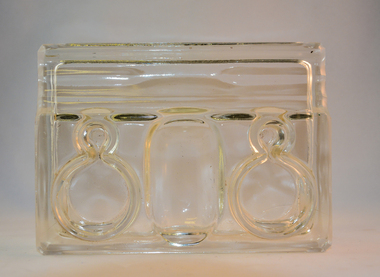 Kiewa Valley Historical Society
Ink Well Desk Set, circa mid to late 1900's
The "nib" pen was the preferred scribe method up until the "fountain" pen was produced (1940's), both could use specific inks that had longer life periods on paper surfaces. Ink wells such as those incorporated in this desk set allowed the user to select the colour and "type of ink" required. The nib pen was the only writing pen that could tolerate "Iron gall" ink. Legal documents were at the start of the mid 1980's required by law(in Australia) to be signed by "well" filled pens. The inks used were either "indian" or "iron/oak gall" because their infusion into paper could not be erased and they had a longer "paper" life and were harder to forge. Bottled ink was superior to that supplied in fountain pens or "biro pens" because the user's choice to a greater range of inks covered a variety of scenarios. Forging a nib signature is extremely hard compared to that of a "biro pen" because a nib settles in to the users particular style of pen movement and arm pressure.This desk writing set was typical of those used by administrators, businesses or quasi legal sectors within the Kiewa Valley, before the lifting of the ban on the use of biros "to sign" legal documents. Fountain pens were used extensively before cheaper biros (throw away) writing implements (1940's) came into the market place.This glass ink well desk set has two circular ink wells connected to their respective nib holders. The nib holders are smaller circular receptacles and feed off the larger ink reservoirs. Between the two larger ink wells is a shallow bottomed elongated "oval" sphere able to contain "slide on" clips, two pronged fasteners (require a hole to be punched in papers) or small "bulldog" clips. At the front edge is an elongated and grooved (two) place for writing nibs. The grooves keep each nib or fountain pen separated.The glass structure is made from clear glass and only the outside "boxed" walls of the desk set make contact with the desk surface. The ink wells can also securely accommodate small bottles of ink. This would have been the case for refillable fountain pens.stationery, fountain pens, nib pens, ink receptors, glass ink wells -
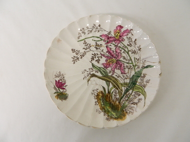 Kiewa Valley Historical Society
Plate - Gilt, 1870 -1920
This gilt plate is from an era where master crockery manufacturers where either located in Britain or Europe.The cost of transportation and the time taken to receive items limited the availability of first class goods. This was an era that was "British is best" in all manufactured goods. With the slow influx of European immigrants European manufactured goods also became of high value. This social requirement was more of a prerequisite for the more affluent rural population, especially at a time when Australia "rode on the sheep's back". Fine British and European goods were a "status symbol", even in rural Australia. After World War II, the invasion of American and Japanese merchandise opened up the market place for cheaper "throw away" items. Longevity and quality of goods fell away as the "throw away" society rolled on.This item demonstrates the time when the rural sector was at its most affluent and influential in dictating the strong ties between Australia, Britain and Europe. The very influential "Country Party" ensured that the protection of the rural sector was well entrenched. The ability of the "well off" rural sector, in this period, were not only able to travel abroad but also to purchase expensive items "overseas" cutlery and crockery. The significance of this item is that it highlights a period in time when the "rural" affluence was at its peak.This hand painted floral gilt plate is a cream fluted china plate decorated with pink and yellow orchid flower arrangement. It is in the "Art Nouveau" period 1880-1920.underneath and within the circular base and in gold freehand script "4" underneath "1562". Pressed into the base is the manufacturer's monogram.Circled around the FAM mark is "* FRANZ ANT. MEHLEM*BONN A/RHEIN*"hand painted china, floral gilt plate, decorative china -
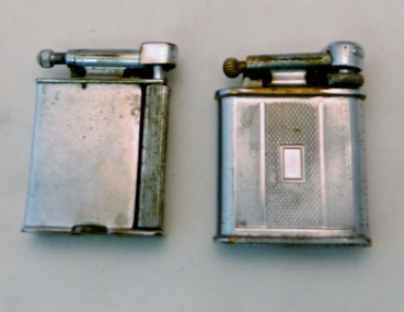 Kiewa Valley Historical Society
Lighter Lift Arm, Circa 1930's to 1940's
This cigarette or pipe lighter was in use in the mid 1900's when the majority of users were men. Ladies did smoke but mainly not in "public" The activity was still regarded as a male activity. Middle to Upper "Class" of women nearly always had a gentleman "at hand" that would "light up" her cigarette. This was seen as a "social" activity only but later in the mid 1900's onward it was quite acceptable for both sexes to "smoke" at anytime.This type of lighter was male orientated due to the degree of lighting the flint with the horizontal movement required a strong thumb action across the lighting wheel. It is significant to rural areas such as the Kiewa Valley as the majority of men (especially during and after World War II) regarded smoking as a way to ease off the "tension" of hard work. The socio-economics of the Australian work place changed after the emancipation of women in the "workforce" after the World War II depleted the male workforce for the duration of the War and changed the Australian ethics of women in all aspects of both city and rural working "so called" male only occupations.This Polo Swift lift arm cigarette/pipe lighter has a chrome plated shell and is fueled by petrol. To operate this lighter you lift the "snuffer" arm exposing the wick, then scrape the flint wheel to create a spark from the adjacent flint(resting on the brass ignition wheel).At the bottom of the lift arm station "POLO". Each side of the lighter are "Art Deco line running from the top of the lighter to the bottom. Between these is a rectangular box with "diamond crossed lines"early hand lighters, smoking in the 1930's, cigarette lighter, tobacco, cigerettes, lighter -
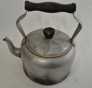 Kiewa Valley Historical Society
Kettle Aluminium, mid to late 1900's
This aluminium kettle was manufactured between 1940 to 1960's and replaced the heavier caste iron "open fire" stove ones (in doors or in the bush). A cast iron flat base between the open fires and the kettle was required. This kettle was used extensively with indoor open fire places. It was part of the evolution in "tea" making kettles. These were the only method of making hot beverages before introduction of electric kettles. For the Kiewa Valley the connection to the major electricity grid was post 1950's.This kettle is significant demonstrating the type of kitchen utensils required before electrical home connections became a reality. The aluminium structure of the kettle was an advancement over the heavier caste iron kettles. This type of kettle is still in use for bush and mountain hikers/climbers due to the light weight. This kettle was used by the Tawonga C.W.A. Branch. The C.W.A. motto "Honour our God, Loyalty to the throne, Service to the country, Through country women, For country women, By country women."This 99% aluminium hot plate kettle with lid (bakelite handle) is Australian made for flat stoves (cooking or room heating). It has a "tea style" spout and a bakelite hand grip(knob) on the top of the lid. The lid has nine ridges (for strength) radiating from the central hand grip. The two handle prongs are bop riveted onto the the body of the kettle. The bakelite hand grip has been fashioned to fit the natural contours of a clutching hand.On both sides of the aluminium handle "HOT PLATE WARE" and covering an oblique shaped triangle "99% PURE ALUMINIUM" and below that "MADE IN AUSTRALIA".Within the triangle "DURALIFE"cwa, homeware aluminium kitchen utensils, made in australia cook ware -
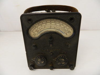 Kiewa Valley Historical Society
Meter AVO, circa 1930 to 1951
When this AVOMETER was being utilised in the early 1950's it was at the "leading" edge of electrical measuring instrumentation.The first meter was produced by Automatic Coil Winder and Electrical Equipment Co. in 1923. This model was produced in the time from 1933 to 1951 when it was superseded by the most popular model, Model 8 (1951 to 2008).This AVO meter brought the measuring of three electrical power indicators i.e., amps, volts and ohms into one measuring unit. By using a "one fits all" unit, the carrying of separate measuring devices was reduced considerably. The need for a mountainous and a large area of operational requirements, such as the SEC Vic Kiewa Hydro Electricity Scheme, to minimise the weight of equipment carried by electricians and technicians was of the utmost relevance. The significance of this meter to the Kiewa Valley region relates to the impact of modern technology (at that time) upon a mainly rural environment. This equipment shows how the boost of "modern" equipment into the area because of the "Hydro Scheme" was facilitated a lot faster than would have taken under "normal" evolutionary time. The speed of information on all "new technology" had a relatively slow assimilation rate to those living in rural communities. This AVOMETER is a Model 7 MKII, production pre 1951. This meter measures electrical Amps, Volts and Ohms and has two internal batteries for its power. The main casing is made from aluminium with a bake-lite front. The front has a "window" detailing, with a needle pointer, the amount of electrical power being tested. There are two big dial switches, detailing Direct Current(DC) and Alternating Current(AC) when reading measurements of Ampere, Voltage and Ohms for power. This meter took the place of three or four meters used earlier. Modern meters (2000 onwards) have become digilised and are considerably lighter in weight and smaller. There are two electrical connection leads (one black and one red) each has a removable clasp and is 125cm long.Molded on the front centre panel " UNIVERSAL AVOMETER". Below this and above the left hand dial "D.C. SWITCH" .Above the right hand switch the right "A.C. SWITCH". On the left of each switch is an arrow pointing to it.The left switch is marked with a "+" and the right one with a "-". There is a "divisional 2" mark. Between and below the dials is "CUT OUT" plunger.electrical meters, electrical equipment, sec vic., state electricity commission of victoria, mt beauty, bogong village -
 Eltham District Historical Society Inc
Photograph, Woodburn residence, mudbrick adobe (1949), Eltham Heritage Tour, 24 May 1992, 24/05/1992
ELTHAM HERITAGE TOUR The Society excursion on 24th May 1992 was arranged by David Bick, leader of the team carrying out the Shire's heritage study. David selected a number of sites or buildings identified in the study, some of them lesser known components of the Shire's heritage. The tour commenced at the Eltham Shire Office at 10.00 am. Travel was by private car and mini-bus with stops at about twelve locations for commentary by David.It included a short walk in Hurstbridge and lunch at Kinglake. Highlights of the tour included: - 10 am Leave from Shire Offices - 3 Important Trees - A Physical Link to Eltham's First Settlers - Toorak Mansion Gates - A Surviving Farm House - An Intact Circa 1900 Main Street - First Settlers - Gold Miners, and Timber-getters - An Early Hotel - A Pioneering Homestead - Changing Eltham Shire - 20th Century - 4 pm Afternoon Tea and Finish Tour Extract from ELTHAM CULTURAL HERITAGE TOUR (Newsletter No. 85, July 1992, by Bettina Woodburn) "In some respects Eltham is a 'back-water' and it has its own distinctive flavour. On the outskirts the homes date from the 1960's, 70's and 80s with a sprinkling of 'earth homes', mud-brick or pise, rammed dirt. Crossing Main Road into Beddoe Street and Thompson Crescent a very pleasant drive past pines and old fence lines, front lawns unfenced, the occasional ·old farm building, we eventually looked down on a huge circular roof of a 1992 adobe home. Other distinctive places included the Pauline Toner Butterfly Reserve, Gordon Ford's splendid garden at Fulling in Pitt Street, cypress hedges and old houses in Bridge Street and in every direction Eltham's special feature - a totally treed horizon. We were now in the part of the Shire closest to Melbourne - Montmorency - not on the way to anywhere, with no through road going across it, developed in the 1950's and 1960's with conventional gardens, now converted to native plants. The rail looped between Greensborough and Eltham and a shopping street (Were Street) served the area, growing up the hill from the station. It was a typical outer Melbourne suburb with lawns and roses with patches of originality. The shopping precinct still has 1950 characteristics - walls which sloped back, projecting roofs, the original shop fronts are nearly all tiled below the old windows. There's an air of past times about the School, the Dairy, the Butcher's (now a milk bar) and the Castlemaine stone face of the Commonwealth Bank. The final stop for the tour was at the mud-brick Woodburn residence, adobe of 1949 with additions. After War Service, Bill Woodburn had commenced an Architecture course at Melbourne University and after second year in the Christmas vacation, with his wife, Betti, built the two bedroom house - with amazing saving of costs. In the three and a half months they made over 3000 bricks (external walls 18" x 12" x 4", internal walls 12" x 9" x 4"), sifted top soil for mortar and laid them, on concrete foundations and slab floor, made all the structural window frames, door frames and roof members to carry 'super six' asbestos sheets, laboured for the electrician and plumber, did all the glazing and, still without electricity, moved in in March 1949. Rooms have been added, at first with glass walls, later using concrete blocks, to accommodate three daughters and a son. The house not only grew from the earth, but also with the family."Record of the Society's history and activities and highlighting various aspects of the Heritage Study undertaken by David Bick used to create the future heritage overlay for the Shire of Eltham and later Nillumbik Shire.Roll of 35mm colour negative film, 4 stripsKodak Gold 100 5095shire of eltham historical society, activities, heritage tour, woodburn house -
 Eltham District Historical Society Inc
Photograph, Upper Yarra Dam, Spring Tour, 22 Oct 1995, 22/10/1995
EXPLORING THE UPPER YARRA (Newsletter No. 105, November 1995, by Bettina Woodburn) We enjoyed the Spring Excursion, this year "Exploring the Upper Yarra" - in spite of the constant rain and the countryside under the cloud cover, especially in the valleys, being mainly shiny shades of green. The occasional fields of buttercups, clumps of arum lilies and splendid rhododendron and other flowering bushes became very special. The Cobb and Co coach was warm and a cosy retreat as we zig-zagged on the highways and byways to glimpse the Yarra River, upstream and down, its secret places, and particularly the many bridges. Russell excelled as 'Poet Laureate', reading from Dacre Smyth's book. This 1979 publication includes paintings of all the bridges along the river with poems and brief descriptions of each one. Some of the bridges are in out of the way places and are not very well known. We looked forward to hearing the poetry as much as seeing the ' constructions'…Big Pat (was he short or tall, lean or fat? He did win the two hundred pound reward for discovering gold and had the creek named after him), about the 'Eddies'?, and the disliked 'meccano' bridge in Warburton, etc. etc. The hot roast lunch in the old Reefton Hotel was also most welcome. It was easy to imagine it peopled by miners and early settlers. Starting by crossing the new (1974) concrete bridge at Warrandyte we headed through Wonga Park with views to the Christmas Hills and to the escarpment of the Yering Gorge, which causes flood waters to back up through the Yarra Glen plain, so avoiding disasters downstream. At the end of a long driveway we found the wooden, privately owned Henley Bridge (1935 after the 1934 floods). This facilitates access to different parts of Henley Farm and to Lilydale. Everard Park, named after Blanche Shallard's father, a State Member for 17 years, below the Highway Yarra crossing was in need of care. It is 10 miles from Yarra Glen by road but, as "Yarra Marra” canoeists well know, 32 winding miles down by water. After more delightful countryside scenes we joined the Warburton Highway at Woori Yallock. From the old Railway Station at Launching Place the Centennial Trail for walkers, cyclists and ' horse riders has replaced the rails. The line from Lilydale was opened in 1901, and the last diesel freight train ran to Warburton in 1965. It continued to rain as we had morning tea in Warburton in a shelter between footbridges. From here we continued upstream past the Bridge to O'Shannasy Lodge and Reservoir, Starvation Creek, and the Peninsular tunnel (miners dug it as at Pound Bend) which we visited (scrambling down those steps!) on our return after lunch. Our furthermost point was the Upper Yarra Dam Reserve (and vast catchment area). Finished in 1957 after ten years work and 100 years after Yan Yean, it supplies much of Melbourne's water. After crossing the 30m Launching Place Bridge to the Eltham side of the Yarra and Healesville, we saw in the distance the Yarra Glen Timber Trestle Bridge over the river flats "the longest for years in the land it was said!" Harry's dream of "better weather over the Divide" unfortunately didn't come true, but I'm sure we 36 members will retain happy memories of a day that was wet and green and filled with Bridges. Bettina Woodburn - October 1995 Record of the Society's history of activities - Spring 1995 excursionRoll of 35mm colour negative film, 3 stripsKodak Gold 200-4shire of eltham historical society, activities, upper yarra dam, henley bridge -
 Eltham District Historical Society Inc
Photograph, Upper Yarra Dam, Spring Tour, 22 Oct 1995, 22/10/1995
EXPLORING THE UPPER YARRA (Newsletter No. 105, November 1995, by Bettina Woodburn) We enjoyed the Spring Excursion, this year "Exploring the Upper Yarra" - in spite of the constant rain and the countryside under the cloud cover, especially in the valleys, being mainly shiny shades of green. The occasional fields of buttercups, clumps of arum lilies and splendid rhododendron and other flowering bushes became very special. The Cobb and Co coach was warm and a cosy retreat as we zig-zagged on the highways and byways to glimpse the Yarra River, upstream and down, its secret places, and particularly the many bridges. Russell excelled as 'Poet Laureate', reading from Dacre Smyth's book. This 1979 publication includes paintings of all the bridges along the river with poems and brief descriptions of each one. Some of the bridges are in out of the way places and are not very well known. We looked forward to hearing the poetry as much as seeing the ' constructions'…Big Pat (was he short or tall, lean or fat? He did win the two hundred pound reward for discovering gold and had the creek named after him), about the 'Eddies'?, and the disliked 'meccano' bridge in Warburton, etc. etc. The hot roast lunch in the old Reefton Hotel was also most welcome. It was easy to imagine it peopled by miners and early settlers. Starting by crossing the new (1974) concrete bridge at Warrandyte we headed through Wonga Park with views to the Christmas Hills and to the escarpment of the Yering Gorge, which causes flood waters to back up through the Yarra Glen plain, so avoiding disasters downstream. At the end of a long driveway we found the wooden, privately owned Henley Bridge (1935 after the 1934 floods). This facilitates access to different parts of Henley Farm and to Lilydale. Everard Park, named after Blanche Shallard's father, a State Member for 17 years, below the Highway Yarra crossing was in need of care. It is 10 miles from Yarra Glen by road but, as "Yarra Marra” canoeists well know, 32 winding miles down by water. After more delightful countryside scenes we joined the Warburton Highway at Woori Yallock. From the old Railway Station at Launching Place the Centennial Trail for walkers, cyclists and ' horse riders has replaced the rails. The line from Lilydale was opened in 1901, and the last diesel freight train ran to Warburton in 1965. It continued to rain as we had morning tea in Warburton in a shelter between footbridges. From here we continued upstream past the Bridge to O'Shannasy Lodge and Reservoir, Starvation Creek, and the Peninsular tunnel (miners dug it as at Pound Bend) which we visited (scrambling down those steps!) on our return after lunch. Our furthermost point was the Upper Yarra Dam Reserve (and vast catchment area). Finished in 1957 after ten years work and 100 years after Yan Yean, it supplies much of Melbourne's water. After crossing the 30m Launching Place Bridge to the Eltham side of the Yarra and Healesville, we saw in the distance the Yarra Glen Timber Trestle Bridge over the river flats "the longest for years in the land it was said!" Harry's dream of "better weather over the Divide" unfortunately didn't come true, but I'm sure we 36 members will retain happy memories of a day that was wet and green and filled with Bridges. Bettina Woodburn - October 1995 Record of the Society's history of activities - Spring 1995 excursionRoll of 35mm colour negative film, 2 stripsKodak Gold 100-4shire of eltham historical society, activities, upper yarra dam, henley bridge -
 Eltham District Historical Society Inc
Photograph, Upper Yarra Dam, Spring Tour, 22 Oct 1995, 22/10/1995
EXPLORING THE UPPER YARRA (Newsletter No. 105, November 1995, by Bettina Woodburn) We enjoyed the Spring Excursion, this year "Exploring the Upper Yarra" - in spite of the constant rain and the countryside under the cloud cover, especially in the valleys, being mainly shiny shades of green. The occasional fields of buttercups, clumps of arum lilies and splendid rhododendron and other flowering bushes became very special. The Cobb and Co coach was warm and a cosy retreat as we zig-zagged on the highways and byways to glimpse the Yarra River, upstream and down, its secret places, and particularly the many bridges. Russell excelled as 'Poet Laureate', reading from Dacre Smyth's book. This 1979 publication includes paintings of all the bridges along the river with poems and brief descriptions of each one. Some of the bridges are in out of the way places and are not very well known. We looked forward to hearing the poetry as much as seeing the ' constructions'…Big Pat (was he short or tall, lean or fat? He did win the two hundred pound reward for discovering gold and had the creek named after him), about the 'Eddies'?, and the disliked 'meccano' bridge in Warburton, etc. etc. The hot roast lunch in the old Reefton Hotel was also most welcome. It was easy to imagine it peopled by miners and early settlers. Starting by crossing the new (1974) concrete bridge at Warrandyte we headed through Wonga Park with views to the Christmas Hills and to the escarpment of the Yering Gorge, which causes flood waters to back up through the Yarra Glen plain, so avoiding disasters downstream. At the end of a long driveway we found the wooden, privately owned Henley Bridge (1935 after the 1934 floods). This facilitates access to different parts of Henley Farm and to Lilydale. Everard Park, named after Blanche Shallard's father, a State Member for 17 years, below the Highway Yarra crossing was in need of care. It is 10 miles from Yarra Glen by road but, as "Yarra Marra” canoeists well know, 32 winding miles down by water. After more delightful countryside scenes we joined the Warburton Highway at Woori Yallock. From the old Railway Station at Launching Place the Centennial Trail for walkers, cyclists and ' horse riders has replaced the rails. The line from Lilydale was opened in 1901, and the last diesel freight train ran to Warburton in 1965. It continued to rain as we had morning tea in Warburton in a shelter between footbridges. From here we continued upstream past the Bridge to O'Shannasy Lodge and Reservoir, Starvation Creek, and the Peninsular tunnel (miners dug it as at Pound Bend) which we visited (scrambling down those steps!) on our return after lunch. Our furthermost point was the Upper Yarra Dam Reserve (and vast catchment area). Finished in 1957 after ten years work and 100 years after Yan Yean, it supplies much of Melbourne's water. After crossing the 30m Launching Place Bridge to the Eltham side of the Yarra and Healesville, we saw in the distance the Yarra Glen Timber Trestle Bridge over the river flats "the longest for years in the land it was said!" Harry's dream of "better weather over the Divide" unfortunately didn't come true, but I'm sure we 36 members will retain happy memories of a day that was wet and green and filled with Bridges. Bettina Woodburn - October 1995 Record of the Society's history of activities - Spring 1995 excursionRoll of 35mm colour negative film, 4 of 5 stripsKodak Gold 400-5shire of eltham historical society, activities, upper yarra dam, henley bridge -
 Kiewa Valley Historical Society
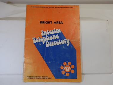
Book - Telephone Directory - 'Bright Area', Bright Area / Interim / Telephone / Directory (1974)
STD (Subscriber trunk dialling) codes were introduced in Australia between 1971 and 1996. 'STD is fast, convenient and easy. Calls can be cheaper .. so use it for all it's worth.' This directory lists all the town's area codes in each Australian state and explains how STD operates.This list is followed by an 'Alphabetical list of the Bright Area Telephone subscribers.The 'Bright' area included Mt Beauty, Dederang, Bruarong, Kergunuyah, Kiewa, Mitta and Tallandoon.The 1974 directory gives the names and addresses of residents and businesses in Mt Beauty and the Kiewa Valley.Looks like an orange exercise book with black and white print and a blue arrow pointing to the bottom left corner..Book is held by 2 staples. Includes an index of places and information available in this directory. Between first pages a piece of paper is inserted. It has the heading "Subscriber Trunk Dialling (S.T.D.) 18 places named 6 of which have the 060 code.telephone directory 1974, mt beauty telephone directory 1974, mt beauty resident's addresses 1974 -
 Kiewa Valley Historical Society
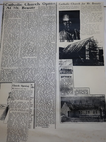
Booklets and Papers - St Joseph's Catholic Church Mt Beauty, St Joseph's Catholic Church Mt Beauty Golden Jubilee 1954-2004
Catholics from Tawonga attended Mass at Dederang the area being part of the Myrtleford parish. With the coming of the State Electricity Commission and the increase in population Masses were said in various schools, homes and halls between Tawonga and Mt Beauty until the completion of St Joseph's ChurchSt Joseph's Catholic Church, Mt Beauty was consecrated on November 7th 1954. The SEC allocated land to each of the churches for them to provide their own places of worship. It was built by volunteers who donated money and their time to raise funds and build the church.1. Booklet with yellow cover, black print and 28 pages back to back held by 2 staples. 2. Booklet "Mass to Celebrate the 40th Anniversary of St Joseph's Church Mt Beauty 1954-1994" 4 pages back to back 3. Papers: vary - 1. A3 sheet with articles from newspapers "Catholic Church Opens At Mt Beauty"; "Catholic Church for Mt. Beauty". 2. x4 A4 sheets typed back to back -"Recalling the first 40 years" 3. St Joseph's Mt Beauty 1968-69 Lawn Cutting Roster 4. Miscellanious st joseph's mt beauty, catholic church, golden jubilee, religion -
 Kiewa Valley Historical Society
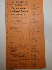
Programme - 29th Annual Combined Sports 1971, Kiewa Valley Schools' Sports Association
Combined school athletic sports were held annually. This one was between 11 teams: Mt. Beauty Black, Tawonga Purple, Mt Beauty Gold, Dederang, Mt Beauty Blue, Tawonga South, Mt Beauty Green, Bogong, Kancoona and Kergunyah South. Events included High Jump, Long Jump for Boys and Girls and Triple Jump for Boys. Also, Potato Race, Zig Zag team of 6, and Bounce Ball. Flat Races boys and girls. Championship for Boys and Girls Under and Over 10 years.Relay Team Open, Skip Ball Open. Tunnel Ball Open,.Circle Gap Open and a Boys and Girls Circle Gap 220 yards.Primary Schools from the Kiewa Valley held athletic sports each year. The schools consisted of small and big schools in the Kiewa Valley. The events included running and jumping as well as team 'fun/novelty' events.Events were run according to age and differed between boys and girls.Orange cardboard athletic sports programme folded in half with 69 events listed with "Officials" named and children's names or teams listed. "Don't you Think It's True You Ought To Be in Blue" penned on the front. "Good Old Blue. Blue Forever. We stick to First Place." "Blue is the Best" "No Sweat to Blue" penned on the fold in the middle. "Good Old Blue" and "Blue" penned on the back.athletics., athletics sports day, school sports, kiewa valley sports -
 Kiewa Valley Historical Society
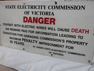
Sign - S.E.C.V
The SECV constructed the KHES and were required to put Safety signs in public and dangerous places.The SECV built the KHES and were responsible for safety signs for the publicLarge metal safety sign warning the public of Danger. Black print with "Danger" and "Death" printed in red. There are 10 holes for erecting the sign onto a eg. building. There is a hole in each corner and one in the centre of the two sides and two equally spaced between the corners of the top and bottom sides.secv safety sign -
 Kiewa Valley Historical Society
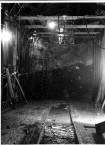
Photograph Tailrace tunnel Arch Drive, Tunnel face at Tailrace showing Arch Drive, between 1943 and 1952
This photo was taking during construction of the tailrace tunnel between West Kiewa Power Station and Mt. Beauty. Much of the area was unstable and timber supports were erected prior to concreting. The tunnel was commenced in 1941 and completed in 1952. It brings water from the power station into the open tailrace at Mt. Beauty and then into the regulating pondage before discharge into the Kiewa River.Shows method of construction for supporting walls and ceiling of tunnel with timber, size of tunnel (note worker on upper level), and conditions in the work place during construction in the 1940's/50's - note the timber ladder to gain access to the upper level.Black and white photographHand written on back of photograph "Tunnel face at Tailrace showing Arch Drive".tailrace, power station, water, construction -
 Eltham District Historical Society Inc
Newsclipping photocopies, Holdup of Commercial Bank, Main Road, Eltham
Articles cover the story of an attempted bank robbery of the Commercial Bank, (Main Road, Eltham) on Thursday 15th December 1949 when shots were exchanged in a bid to prevent the escape of a man who had attempted to rob the bank. A subsequent search took place. 19 year old youth Kay Arthur Morgan was later caught and committed to trial. He had used a stolen gun, 15 shots had been fired.. Two bullets were fired into the ceiling and back wall of the bank, after penetrating the wooden counter and passing in between the legs of the receiving officer Spear. Names mentioned: Senior Constable N. Forbes, Harry Wallace (Manager), Mr. L.A. Spears (Receiving Officer) , Senior Detective H. McMennamin, Mr H. D. Pettie (Mountain View Rd, Montmorency, Detective Sergeant K. Hubbard, Inspector F. Hobley, Senior Inspector R. Newton, Detective P. Pedersen, Detective L Dent, Detective J. Oakers, Includes photosFour pages of photocopies of newspaper clippings with typed source information. Pistol stolen, The Argus, 10th December, 1919 Search of Scrub proves fruitless, The Age 17th December 1949, page 3 Pistol Battle at Bank, The Age 16th December 1949 "Guilty" pleas to pistol theft Court told of lad's hold-up bid, The Argus 23rd February, 1950 page 7 commercial bank, eltham, robbery