Showing 1860 items
matching the rock
-
 Phillip Island and District Historical Society Inc.
Photograph Folder, The Rose Stereographs, Early 20th Century
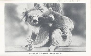
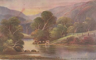
Souvenir history of Phillip Island.A collection of black & white photographs in a souvenir folder. Photographs include: Koalas, Penguins, Seals, The Suspension Bridge, Cowes Pier, Cowes Beach, The Race Track, The Nobbies, Pyramid Rock, The Pinnacles and Forrest Cave. On the front of the folder: Cowes, Phillip Island. Greetings from Cowes, P.I. Inside and description of Phillip Island as shown on Photograph 281-12. 281.01. Koalas, or Australian Native Bears. 281-02. "Come on, Hurry, Baby's waiting." 281-03. View of Suspension Bridge, looking from San Remo to Phillip Island. 281-04. View from the Pier, Cowes. 281-05. On the Seal Rocks, Phillip Island, Vic. 281-06. Western Beach, Cowes, Phillip Island. 281-07. The straight, Racing Circuit, Cowes, Phillip Island. 281-08. the Nobbies, Phillip Island. 281-09. The Pyramide, Back Beach, Phillip Island. 281-10. The Pinnacles, Cape Woolamai, Phillip Island. 281-11. Forest Cave, Phillip Island, Vic. wildlife - koala, wildlife - seals, wildlife - penguins, the nobbies, the pinnacles, forrest caves, pyramid rock, cowes foreshore - cowes pier - phillip island, cowes beach phillip island, phillip island suspension bridge, phillip island race track, stan harris -
 Glenelg Shire Council Cultural Collection
Print - Contact Print, 1960-1979
Black and white contact print from glass plate negative. Image shows a group of 5 women and a boy sitting on a rock platform, with their backs to a cliff. Dress late 19th, early 20th century. -
Glenelg Shire Council Cultural Collection
Photograph - Photograph - Shelly Beach, Bridgewater Bay Victoria, n.d
Black and white photo - original photo 7763 7763 - Black and white photo of natural rock arch at Shelly Beach. Mr. H.L. Vivian , dressed in a suit and with a walking stick, is standing beneath the arch.Back: '56' in pencilshelly beach -
 Halls Gap & Grampians Historical Society
Photograph - B/W, C 1960s (?)
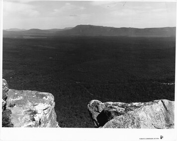
The photo is taken from Reed's Lookout.The photo shows the view across a valley from a (Reed's Lookout). The foreground is two large rock platforms. A reservoir (Moora Moora) and ranges can be seen in the background. Roads can be seen in the valley in the foreground.'Forests Commission, Victoria' inscribed on bottom, right of border. 'Publicity & Public relations Branch, When reproducing please Acknowledge Forests Commission, Victoria, Negative No. 322-23' stamped on back.scenery, lookouts -
 Halls Gap & Grampians Historical Society
Photograph - Coloured
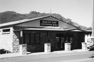
Halls Gap Hall c2000. for further info see Rec.389. A stone faced building with a veranda in front. The supports are surrounded by rock piers. A sign appears over the door "Halls Gap Centenary Hall". A vehicle is parked in front of Building. Mt. William Range is in background.buildings, halls -
 Australian Commando Association - Victoria
Book, Strike Swiftly - 40 years of 2 Commando Company - 1955 -1995, Printed January 1995
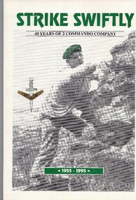
It gives a concise history of 2 Commando Company, from 1955 when it was formed, to 1995, giving details of its Officers Commanding, including its founding OC, their philosophies, and general and significant Company events and personnel over the 50 years. It has 3 chapters describing the development of Australia's Special Forces.Written to mark the 40th anniversary of 2 Commando Company, and presented to all 2 Commando Association members and friends who attended the 40th anniversary dinner in February 1995. Gives a 40 year history of the Company. Soft cover; White cover, green main title. Contains chronological concise history of the Unit, also with themed chapters, with limited photographs. Cover photo of Commando rock climbing, wearing green beret.NLA ISBN 0 646 22208 2. Copyright 1995.40th anniversary- 2 commando company- 2 commando association-40th anniversary-officer commanding- founding oc-australia special forces -
 Port Melbourne Historical & Preservation Society
Photograph - Construction of rock wall at George Samuel Walter Memorial Garden, Jack GOULD, C. 1950-55
From a box of photographs in Nancy U'REN's papers used during research for her thesis, The Early Growth and Development of Sandridge (1976) and/or her book with Noel TURNBULL, A History of Port Melbourne (1983). Black and white photograph showing Crockford Street as it turns into Bay Street. A worker is bent over on the edge of George Samuel Walter Memorial Garden next to a pile of rocks beginning the construction of the rock wall.bay street, crockford street, port melbourne town hall, george samuel walter memorial garden, nancy u'ren nee morris -
 Bendigo Historical Society Inc.
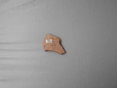
Geological specimen - GRAPTOLITE COLLECTION: TETRAGRAPTUS FRUTICOSUS (J. HALL) (3 BR.)
Tetragraptus fruticosus (J. Hall) (3 br.) Bendigonian. Cream coloured rock, 'Be19' on sticker next to graptolite specimen. Graptolite specimen was formerly held in the School of Mines Museum, Pall Mall, Bendigo. -
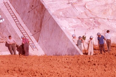 Stawell Historical Society Inc
Slide, Ian McCann, Abutment Wall Bellfield, 1965
Colour Slide: Outside A Group of 7 men 5 tot he right and two to the left side of photo standing in frount of rock and concretes wall , a ladder attached to the conrete lfet side of photograph. -
Lakes Entrance Regional Historical Society (operating as Lakes Entrance History Centre & Museum)
Photograph, Judy Davies, March 2001
Also two photographs taken inside Schnappers Cottage showing tongue and groove lining, coved ceiling, dado above wide vertical wall boards 04653.1 and 04653.2 15 x 10 and 10 x 15 cmColour photograph of Schnapper Cottage a small white painted dwelling with a red roof situated on the edge of lake edged with rock groyne and remains of timber railing at western side of entrance at Lakes Entrance Victoriaforest -
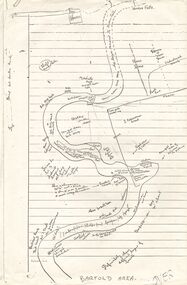 Bendigo Historical Society Inc.
Document - PETER ELLIS COLLECTION: SKETCH OF THE BARFOLD GORGE
Two photocopies of hand-drawn sketch of the Barfold Gorge. On the sketch is the location of a house, trees, fences, different types of rock, some accessible areas to get down to the river, geological features and water falls.place, land, barfold gorge, peter ellis collection, barfold area, mitchell's falls, queen's fall -
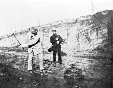 Surrey Hills Historical Society Collection
Photograph, Surrey Hills Golf Club - the cutting in (now) Whitehorse Road, 1905, 1905
Reproduced by permission of Mr John Arnold from his book: "The Riversdale Golf Club - a history, 1892-1977." Copyright to book: Riversdale Golf Club. Surrey Hills Golf Club operated from 1892-1908 then moved and became Riversdale Golf Club. The game was played across paddocks from Trafalgar Street, Mont Albert to Whitehorse Road and down Victoria Crescent to where Box Hill TAFE is now located in Elgar Road. There were problems with cows eating the tee flags! The clubhouse still exists as 30 Trafalgar Street. The men are standing on what is now Whitehorse Road in the cutting which can still be seen near the Box Hill Motel. Walter John Carre Riddell: Born c1859; died 12 March 1930; unmarried. Father came from Riddell in Scotland and took up land at Riddell's Creek, near Gisborne. W J Carre Riddell was educated at Melbourne Grammar, graduated in law from Melbourne University in 1882 and practised law until 1907. MLA for West Bourke for 17 years. Chairman of MMBW from 1907 until retirement in 1927. Versatile sportsman. REF: Obituary in Trove - The Argus, 13 March, 1930, p8.The image is significant for its association with Walter John Carre Riddell who was a significant identity in early 20th century Melbourne. His was well-known for his sporting prowess. In early life he was a keen footballer, cricketer and tennis player. In his later years he took up golf. Was President of Royal Melbourne Golf Club and Chairman of the Victorian Golf Association. The 'coffin hole' was a notoriously difficult position to play out from.Black and white photo of 2 men, one swinging his golf club; the other carrying a golf bag and watching. They are dressed in suits and hats and are standing in a cutting, the face of which shows rock strata."W. J. Carre Riddell playing out of the coffin, 1905."sports grounds, surrey hills golf club, riversdale golf club, jon arnold, w j carre-riddell, walter john carre riddell -
 University of Melbourne, Burnley Campus Archives
Plan - Plans and photographs, Burnley Low Energy Greenhouse, c. 2008
Laminated plans for greenhouse (1) Burnley Low Energy Greenhouse, (2) Solar Boosted Heat Pump - Greenhouse Bench Heating System. C photographs pasted on cardboard and labelled (3) Loading 20 mm gravel into Rock pile. (4) Reinforcement at Bottom Gravel level. (5) Sealing the Top of the Rock pile. (6) Top of Rock pile Before A-Frame Construction. (7) Corner Detail of Portal Frame. (8) Glazing Frames for Solar Panels. (9) Structure Partially Clad, with Solar Panel Supports at Rear. (10) Back of Solar Panels in Place. Laminated C photographs pasted on cardboard and labelled. (11) Burnley Low Energy Greenhouse. (12) Greenhouse Covering Materials Burnley. Pamphlet (13) Burnley College Institute of Land and Food Resources (slightly damaged)burnley, greenhouse, solar energy, construction, pamphlet -
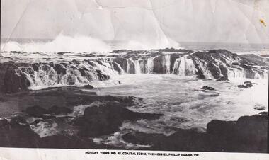 Phillip Island and District Historical Society Inc.
Photograph, The Nobbies
Coastal view of The Nobbies area depicting platform rocks, surf, pounding behind them. Rock and calmer water in the foreground.Coastal scene at The Nobbies, Phillip IslandMurray Views No. 45. Coastal Scene The Nobbies, Phillip Island, Vic.local history, photographs, the nobbies, coastline, phillip island, black & white photograph, mona condrick -
Phillip Island and District Historical Society Inc.
Newspaper clippings
Photographs of sinking of Harbour Trust Dredge "George Kermode" to form an artificial reef a mile south-east of Pyramid Rock.Photographs of sinking of Harbour Trust Dredge "George Kermode" to form a reeflocal history, documents, newspapers, newspaper clipping, dredges, black & white newspaper clipping, harbour trust dredge "george kermode" -
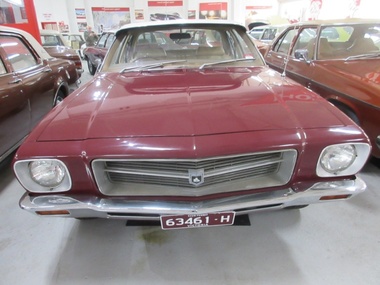 Trafalgar Holden Museum
Vehicle - HQ Holden Kingswood sedan
This was thew first "ground up" redesign of the Holden line since the original release in 1948, and included an all new body suspension and chasis and upgraded brakesMade by General Motors Holden in 1971, a total redesign from the "ground up"4 Door HQ Kingswood sedan Burgundy body with white roof.Holden Lion and rock emblem center of Grille, Kingswood, Trimatic, 202 badges on boot lid Kingswood badges both front mud guards Registered number 63461-Hvechile, hq holden kingswood, car -
 Bendigo Historical Society Inc.
Postcard - Alice McGregor Postcard Collection, 1900 - 1920
Alice McGREGOR Born: 1908; unknown parents. Possibly adopted by the Salter family? Electoral Roll 1936: Highland Terrace Kangaroo Flat. Alice Mary Salter and William Robert Salter living together; presumed to be sister and brother. William Robert Salter was killed in a MVA in Bendigo in 1937 aged 26. In Victoria in 1938, Alice Mary Salter married James Thomas McGregor (born Victoria 1917, died Victoria 1983, buried Fawkner Cemetery) Lived: 1968; 22 Wade Street Golden Square Alice McGregor Died: 1999 aged 91 at Anne Caudle Centre, Bendigo Buried: Kangaroo Flat Cemetery See additional research. Postcard Album of Alice McGregor contained 86 post cards.Postcard Album of Alice McGregor contained 86 post cards. See 1400. Colour painting of a rural scene of 2 cows beside the Yarra at West Warburton. Addressed to Miss H G Shatford, Black Rock, Via Sandringham, Victoria Sender J G D, Emu Park, W East Dated 25 Oct 1906 postcard, collector, alice mcgregor -
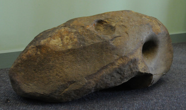 Orbost & District Historical Society
Aboriginal grinding stone, Aboriginal people have shaped this rock through usage, pre-European Australia
This large and very heavy stone was donated by Albert Emphield. Where he found it is unknown, but he worked in the Orbost forest areas and lived at Cabbage Tree Creek.Aboriginal usage, tool manufacture.A large rock of generally oval shape and with a number of flatish surfaces and hole indentations which were identified by archaeologist Dr Joanna Freslov 2.6.2008 as being used by Aboriginal people as a grinding or tool-sharpening stone.aboriginal-grinding-stone -
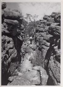 Halls Gap & Grampians Historical Society
Photograph - B/W, C 1960s
Photo is of area known as ' Silent Street'. It is on path to Pinnacle Lookout.Photo shows a man walking along slabs of rock that form a path between rocky outcrops. He is walking away from the camera. Various shrubs line the path. Gum trees can be seen in background.'Copyright photograph'. This photograph may be reproduced on condition that it is acknowledged as 'Victorian Railways Photograph', p3456- Silent Street . Halls Gap.scenery, wonderland range -
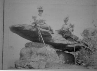 Halls Gap & Grampians Historical Society
Photograph - Sepia
The name " Balmain " has been attributed to the photo, James Balmain and his wife, Amy Sophia [D'Alton} purchased a vacant school cottage from the area and moved it to their land and called it Bellfield. Amy died at age 37, James returned to Scotland with their 3 children.Photo shows 2 women sitting on a rock formation, both are wearing hats adorned with flowers and appear to be wearing long skirts and high buttoned blouses. They are both holding sticks which seem to be decorated with flowers,recreation, bush-walking -
 Federation University Historical Collection
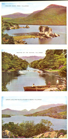
Letter Card, Six View Letter card of Killarney, Ireland
Probably acquired because of its connection to rural life and the Irish immigrants settled in the Ballarat DistrictSix coloured images from Killarney, Ireland. * Colleen Gawn Rock * Meeting of the Waters * Upper Lake and MacGillycuddy's Reeks, Killarney * The Islands, Upper Lake * Kate Kearney's Cottage * Lower Lake and Ross Castlechatham-holmes family archive, killarney, ireland -
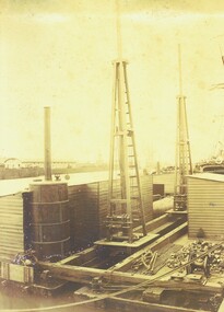
Glenelg Shire Council Cultural Collection
Photograph - Photograph - Main Breakwater construction, Portland, n.d
Port of Portland Authority ArchivesBack: 11 - blue biro Border ruled in pencil Portland "Guardian" - purple stampport of portland archives, main breakwater, construction, portland harbour, harbour development -
 Bendigo Historical Society Inc.
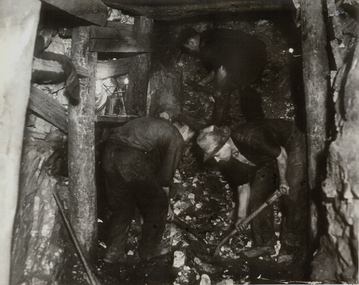
Photograph - UNDERGROUND MINE
Black and white photograph of underground mine working with two workers shovelling rock in foreground, another miner working in upper background. Mine drive (end) showing wooden support posts and associated timber work.mining, underground equipment, miners, bendigo, mines and mining, mines, miners -
 Bendigo Historical Society Inc.
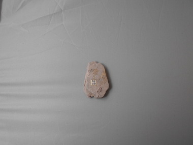
Geological specimen - GRAPTOLITE COLLECTION: DIDYMOGRAPTUS SIMILIS (J. HALL) 41341)
Didymograptus similis (J. Hall) 41341) Bendigonian. Pale brown rock, one specimen. ' Be29' on sticker near graptolite specimen. Graptolite specimen was formerly held in the School of Mines Museum, Pall Mall, Bendigo. -
 Bendigo Historical Society Inc.
Geological specimen - GRAPTOLITE COLLECTION: TETRAGRAPTUS FRUTICOSUS (J. HALL) 3 BR
Tetragraptus fruticosus (J. Hall) 3 br. Bendigonian. Pale grey rock, one specimen. Sticker with 'Be19' alongside graptolite. Graptolite specimen was formerly held in the School of Mines Museum, Pall Mall, Bendigo. -
Bendigo Historical Society Inc.
Geological specimen - GRAPTOLITE COLLECTION: DIPLOGRAPTUS (GLYTOGRAPTUS)
Diplograptus (Glytograptus) austrodentatus H. and R. Middle Ordovician. Grey rock, multiple graptolite specimens on surface. "Mo51' and 'Mo52' on stickers. Fossil collection was formerly held by the School of Mines Museum, Pall Mall, Bendigo. -
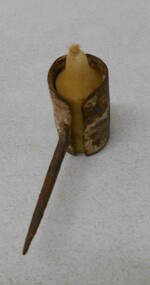 Bendigo Historical Society Inc.
Tool - MINING 'SPIDER' CANDLE HOLDER
Metal candle holder, cylindrical, open top and bottom, with metal spike attached. Used by underground miners. Candle holder was stuck into timbers or rock to provide light. Small stub of candle in holder. Wick fraying.gold mines, mining equipment, candle holder -
 Bendigo Historical Society Inc.
Photograph - R.G.FORD'S SUBMARINE ROCK DRILL AND COMPRESSOR, c. 1879
Sepia tone coloured photograph, R.G.Ford's Submarine Rock Drill and Compressor Made for Melbourne Harbour Trust (c.1879), Markings on rear of photo read 'Central Deborah Collection Copied 18 December 2001'photograph, harbor, r.g.fords, submarine rock drill & compressor -
 Victorian Interpretive Projects Inc.
Photograph - colour, Clare Gervasoni, Rock Art in the Playground of the Former Dry Diggings Primary School, 05/08/2004
... Rock Art in the Playground of the Former Dry Diggings ...The Dry Diggings area is located outside Hepburn Springs in the shadow of Mount Franklin. It was an early goldmining area, but little remains of the thriving town of the 1860s. Colour photograph in digital format of the shape of Australia carved into a rock in the playground of the former Dry Diggings Primary School near Hepburn Springs and Daylesford. The carved area has been filled with white quartz stone. dry diggings, education, rock, -
Tatura Irrigation & Wartime Camps Museum
Photograph, 1936/02
Photo taken by the photographer for Victoria State Rivers and Water Supply CommissionMedium sized black and white photograph. Eildon Reservoir spillway / Concrete structure centre / rock and earth fill dam wall top half / round concrete tower left midway along wall bank.goulburn, irrigation, photo, victoria state rivers and water supply commission, eildon, eildon weir