Showing 1165 items
matching town view
-
 Port Melbourne Historical & Preservation Society
Photograph - Aerial view of Port Melbourne piers and foreshore, Jack GOULD
From a box of photographs in Nancy U'REN's papers used during research for her thesis, The Early Growth and Development of Sandridge (1976) and/or her book with Noel TURNBULL, A History of Port Melbourne (1983). Jack GOULD probably created this from an earlier photograph.Black and white aerial photograph showing the Port Melbourne foreshore and the piers from Princes Pier to Lagoon Pier and beyond. C. 1922-23.piers and wharves - princes pier, piers and wharves - town pier, piers and wharves - lagoon pier, foreshore, piers and wharves - railway pier, nancy u'ren nee morris -
Port Melbourne Historical & Preservation Society
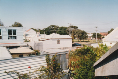
Photograph - View over Bay Street and rooftops towards City of Melbourne, Jack GOULD, 1975
From a box of photographs in Nancy U'REN's papers used during research for her thesis, The Early Growth and Development of Sandridge (1976) and/or her book with Noel TURNBULL, A History of Port Melbourne (1983). Black and white photograph looking toward the city from a rooftop in Bay Street in 1975.bay street, port melbourne town hall, nancy u'ren nee morris -
Port Melbourne Historical & Preservation Society
Photograph - Princes Street, Port Melbourne, Ron Laing, 1999
Ron Laing at the request of the Society photographed the same view as item 799.01 in 1999, prior to the Borer's Bakery site being redevelopedColour photograph taken of Princes Street from the same viewpoint as 1933 photograph of construction workers in the excavation for the main drain in Princes Street (799.01 & .02).built environment, ron laing -
Port Melbourne Historical & Preservation Society
Photograph - Sandridge Lagoon, Latrobe Library, 1920s
Photograph is a copy of one held in the PP Port Melbourne photo collection. It was donated and presented to the PMH&P Society by Joan WINTER of the City of Port Phillip at the August 1996 Annual General Meeting laser copy of photo of Sandridge Lagoon, viewed towards Bay: Western Jetty shown with several fishing vessels alongside. People on the Jetty (some with pushbikes); edge of Harper's building at right. sandridge lagoon, industry - fishing, sport - yachting -
Port Melbourne Historical & Preservation Society
Sign, Alison KELLY, Vintage Port Worth Preserving, c.. 1984
Sign believed to have been made c.1984 as part of the campaign against amalgamation. Large oblong sign with 'Vintage Port' in white and "Worth Preserving' in red on a blue background. Top left has an image of a red topped shipping beacon. The sign has eyelet holes an each corner & in the centre to enable it to be hung. The reverse side has copies of two panoramic views from the late 1900's which were added at a later date & show the view from Station Pier to the city & the reverse.built environment - industrial, built environment - domestic, centenary bridge, commonwealth government engine works, beacon, piers and wharves - princes pier, piers and wharves - station pier, amalgamation -
Port Melbourne Historical & Preservation Society
Photograph, GRAHAM ST. PORT MELB
The rockery and buildings in this area of Graham Street were demolished in the 1970s when the Graham Street overpass was constructed.View of ornamental reserve (rockery) in Graham Street with buildings in the background. The decorative lights of the Maskell & McNab Memorial are visible within the rockery.graham street, parks and gardens, frederick william maskell, james mcnab, maskell & mcnab memorial -
Port Melbourne Historical & Preservation Society
Photograph - Graham Street Rockery
The rockery and buildings in this area of Graham Street were demolished in the 1970s when the Graham Street overpass was constructed.View of ornamental reserve (rockery) in Graham Street with many people, men, women and children standing in front of the rockery and a number of two-storey buildings in the background. The decorative lights of the Maskell & McNab Memorial are visible within the rockery. There is a bicycle leaning against the wall of the rockery at the centre of the image.graham street, parks and gardens, frederick william maskell, james mcnab, maskell & mcnab memorial -
 Port Melbourne Historical & Preservation Society
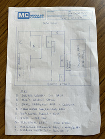
Document, MM Crane Factory - Plan View, 18 Feb 2020
Blue printed plan view of Malcolm Moore Crane Factory with lettered index of areas within the factory from 1979 some with names listed including Norm (presumably Norm Robinson).built environment - industrial, industry, engineering, malcolm moore pty ltd, norm robinson -
Port Melbourne Historical & Preservation Society
Photograph - Digital images of aerial views over Station and Princes Piers, GMH and Fishermans Bend and images of Guard of Honour in March 1924, 18 Mar 1924
Guard of Honour at Princes Pier for Vice Admiral Sir Frederick FIELD, Royal Navy. Donor's father, Eric DOUGLAS is on left in front row.Two digital images of aerial views over GMH, two digital images of aerial views over Fishermans Bend, one digital image of Princes and Station Piers and two digital images of Guard of Honour in March 1924.piers and wharves - princes pier, eric douglas, sir frederick field, royal navy -
 Port Melbourne Historical & Preservation Society
Photograph - View to Crichton Reserve, c.2010
View from Upper story Station Street house to Crichton Reservecrichton reserve -
 Ithacan Historical Society
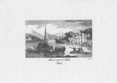
Print, View of the port of Vathi Ithaca, c1820s
"Town and Harbour Bathi. Ithaca" (Vathi) engraved by J. Tingle from artwork by C.Bentley, was published in The Shores and Islands of The Mediterranean ..., about 1840. A reproduction of a black and white etching of the Ithacan port of Vathi. A fishing boat is being brought in to the port and the crew are preparing to unload the catch. There are some buildings around the harbour's edge and smaller boats are also in the harbour.In Italian: Citta e porto di Bathi (Itaca) -
Port Melbourne Historical & Preservation Society
Photograph - Aerial view of Port Melbourne, c. 1990
Notations made as a result of conversations Anne had in the early 1990's with an elderly male resident of Port Melbourne.Map and aerial photo of Port Melbourne with handwritten annotations detailing the location of various buildings, trotting tracks, etc which previously existed in Port Melbourne (recollections only).fishermans bend -
Port Melbourne Historical & Preservation Society
Photograph - Aerial view of Port Melbourne, c. 1972
Aerial photographic view of Port Melbourne c1972local government - city of port melbourne -
Port Melbourne Historical & Preservation Society
Plan - Proposed footbridge over the Lagoon, Bridge Street, Port Melbourne, 1863
Plan of proposed footbridge over the Lagoon in line of Bridge StreetIn ink on reverse, two small drawings: elevation land view over a distance of 25.00 chains (colour tinted), and Plan view, section of an unidentified street:In pencil on reverse, notation '107 Albert Street'sandridge lagoon, robert h morgan -
Port Melbourne Historical & Preservation Society
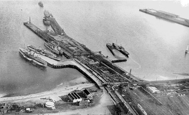
Photograph - Aerial view of Williamstown piers and Alfred Graving Dock, Port of Melbourne Authority, c. 1925
Black and white aerial photo of Williamstown Piers and Alfred Graving Dock, with caption, both pasted onto paper with chequered computer bordertransport - shipping, piers and wharves, williamstown, alfred graving dock -
Port Melbourne Historical & Preservation Society
Photograph - Aerial view of the commencement of Appleton Dock, Aug 1925
Black and white aerial photo of Commencement of Appleton Dock and construction of new river berths, with caption, both pasted onto paper with chequered computer bordertransport - shipping, piers and wharves, yarra river, appleton dock -
Port Melbourne Historical & Preservation Society
Photograph - Aerial view of American destroyers at Victoria Dock, 6 Aug 1925
Copy of aerial photo of Victoria Dock 1925 with destroyers from visiting American fleet, with caption, both pasted onto paper with chequered computer bordertransport - shipping, piers and wharves - miscellaneous, victoria dock -
Port Melbourne Historical & Preservation Society
Photograph - View to north for clock tower, Port Melbourne Town Hall, 1930s
... Poor copy of photo of view to north from Town Hall... environment bay street Poor copy of photo of view to north from Town ...Poor copy of photo of view to north from Town Hall clocktower, possibly early 1930s, showing Fountain Inn, lower Bay Street and Crockford Street Cable tram tracks visible.built environment, bay street -
 Port Melbourne Historical & Preservation Society
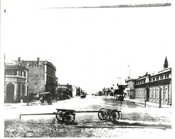
Photograph - Morley's Coal Depot cart, Bay Street, Sandridge, c. 1873
Copy of photo looking north in Bay Street from Beach and Bay, Morley's Coal Depot cart in foreground, c1873On back: view up Bay St circa 1872-3business and traders, william morley -
 Port Melbourne Historical & Preservation Society
Photograph - Aerial view during construction of Station Pier, Port Melbourne, c. 1925
Aerial photo showing the double-headed pier created by partially dismantled Railway Pier and partially built Station Pier, late 1920s. Also the new wing piers with paddlesteamers Hygeia, Weeroona and Ozone (latter being broken up), foreshore and railyards, and end of Princes Pier. Pasted on A4 paper printed with computer generated chequered border.transport - shipping, piers and wharves - station pier, piers and wharves - railway pier, ps weeroona, ps hygeia -
Port Melbourne Historical & Preservation Society
Photograph - Southern pedestrian stairway, Centenary Bridge, Viva, 1989
Black and white photo taken 1989 by 'Viva', an artist from the Mission Arts Centre: southern pedestrian stairway to Centenary Bridge,side viewengineering - bridges, centenary bridge, viva - artist -
Port Melbourne Historical & Preservation Society
Photograph - Aerial view of River Yarra and Victoria Dock, 1920s
Copy of aerial photo of River Yarra and Victoria Dock, 1920s; pasted onto A4 sheet with computer graphics bordertransport - shipping -
Port Melbourne Historical & Preservation Society
Photograph - COR/BP tank farm clean-up, Alison Kelly, Aug 1990
Shot when Alision Kelly was caretaker at the nearby 'Mission Art Centre' and displayed there and at the Port Melbourne LibraryFour colour photos of bulldozer working on clean up process on site of former COR/BP tank farm - view to south. Archivally mounted on vertical strip of white card and enclosed in mylar. Photos all looking south; views of equipment scooping out hydro-carbons, soil from pit filled with ground water; top to bottom: Williamstown and Webb Dock in background; white Toyota EAY-921 right foreground; close up; close up; Princes Pier in left backgroundInk on back: 'A. Kelly 645 2324'town planning - proposals shelved - bayside, environment, alison kelly -
 Port Melbourne Historical & Preservation Society
Photograph - Sketch, View of Sandridge, Booth, 1873
Photograph of sketch - View of Sandridge - Booth, Australia. 1880On rear: E.C.Booth - Australia. 1880. P78built environment, n chevalier, london virtue & co ltd -
Port Melbourne Historical & Preservation Society
Photograph - Canal at Fishermen's Bend, 1886
View of canal at Fishermen's Bend 1886. East end - showing inflow of water, during flooding.On rear: SLTF 919.45 M48F Views of canal at Fishermen's Bend 1886. View No 5 - General view East end - inflow of water.engineering - canals and drainage -
Port Melbourne Historical & Preservation Society
Work on paper - Display panel, Station Pier, Port Melbourne, Alison Kelly, 1988
Photographed and displayed at Missions to Seamen building in 1989 by Alison KellyDisplay panel with three photos (outer beacon; eastern Station Pier kiosk; view of western Station Pier kiosk, beacon, Princes Pier gatehouse and former western paddlesteamer waiting room) glued directly onto black art board, velcro on back.In pencil on back: 'Pat Grainger 70 Station St Port Melb'piers and wharves - station pier, piers and wharves - princes pier, beacons, alison kelly, thirst aid kiosk -
 Port Melbourne Historical & Preservation Society
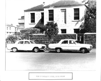
Photograph - House built for Frederick Poolman, Manager, Victorian Sugar Mills, Rouse Street, Port Melbourne, View of Poolman's house, Rouse Street, 1960s
Poolman's house became the manager's house for Harper's when that company took over the area of the former sugar mill. It was demolished late 1970s. Used for Council display purposes and still mounted with caption together with photo of Swallow and Ariell houses.(no.679)Photographic copy of a photo of blue stone two-storey house built for the Manager of the Victorian Sugar MIlls, Frederick POOLMAN. Labelled 'View of Poolman's house, Rouse Street' as part of a display prepared by Council.'131' in blue ink; 'Poolmans house?' in blue inkbuilt environment - industrial, built environment - domestic, frederick poolman, victorian sugar works, colonial sugar refineries -
Port Melbourne Historical & Preservation Society
Postcard, Diana Calder, Spirit of Tasmania, 1994
Left from 'Thirst-Aid' kiosk, Station Pier, when it closedUnused postcard featuring view of Spirit of Tasmania c1994transport - ferries, spirit of tasmania, tt-line co pty ltd -
Port Melbourne Historical & Preservation Society
Postcard, Diana Calder, Spirit of Tasmania, 1994
Left from 'Thirst-Aid' kiosk, Station Pier, when it closedUnused postcard featuring four views of Spirit of Tasmania c1994. (2 copies)transport - ferries, spirit of tasmania, tt-line co pty ltd -
Port Melbourne Historical & Preservation Society
Photograph - Sign, Gainsborough House, Station Street, Port Melbourne, Sign on Gainsborough House,1857, 1950s - 1970s
Full view of house - one of two photographs of 184 Station Street, so-called 'Gainsborough House', mounted together in white card with captions. Houses built by Stevedore Jules Commans late 19th century (erroneous '1857' sign added sometime in the 20th century)built environment - domestic, jules commans