Showing 2417 items
matching townships
-
 Bendigo Historical Society Inc.
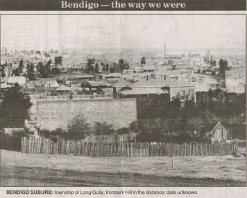
Newspaper - LONG GULLY HISTORY GROUP COLLECTION: BENDIGO - THE WAY WE WERE - LONG GULLY
Black and white photo from Bendigo - the way we were series in the Bendigo Advertiser, November 14, 2000. The photo shows the township of Long Gully, Ironbark Hill in the distance. Date unknown. The photo shows houses, mine chimneys, trees and a rough picket type fence in the foreground.bendigo, history, long gully history group, the long gully history group - bendigo - the way we were - long gully, bendigo advertiser 14/11/2000, ironbark hill -
 Bendigo Historical Society Inc.
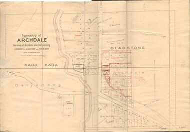
Map - JACK FLYNN COLLECTION: TOWNSHIP OF ARCHDALE, /08/1904
Map: Township of Archdale, Parishes of Archdale and Dalyenong, Counties of Gladstone and Kara Kara. Scale 4 Chains to 1 Inch. Has attached letters relating to land transfers between the Estate of Kate Sanderson and Barry Frederick Mortlock also between Matilda Jane Sanderson and A. O. Proctor.J. K. Spark Narrister & Solicitor, Formerly Mitchell, Monotti & Sparkmap, gladstone, township, archdale, dalyenong, gladstone, kara kara -
 Clunes Museum
Map, 1962
.1 &.2 MAP OF BALLARAT SHIRE GROUP RURAL FIRE BRIGADES FIRE CONTROL MAP. COMPILED BY C. H. FENTON. (2 COPIES) DETAILING SEALED ROADS, STATE FORESTS, PINE PLANTATIONS, FOREST AREAS, RAILWAYS, BOUNDARIES, TOWNSHIP AREAS CEMETERIES, CREEKS, SWAMPS AND HOUSES.local history, document, maps, fire brigade -
 Southern Sherbrooke Historical Society Inc.
Postcard - Postcard-original-Swans Bend Belgrave, Vic. c.1940s, A Bend In The Road, Belgrave
Sepia-toned postcard featuring bend coming into Belgrave Township from the west. Later known as Swans Corner. Dr Shirley Francis's house in centre of photo. Photo shows a hillside with three houses above the road. A man walks along the lower side of the road. c. 1920s. -
 Bendigo Historical Society Inc.
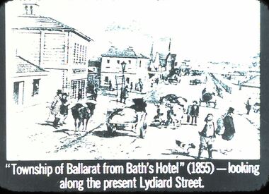
Slide - DIGGERS & MINING: THE DIGGINGS - THE DIGGERS
Diggers & Mining: The Digging - The Diggers. Slide: ''Township of Ballarat from Bath's Hotel'' (1855) - looking along the present Lydiard Street. Shows the hustle and bustle of the towns that have grown from gold. Black and white side. Markings: 41 994.LIF:6. Used as a teaching aid.hanimounteducation, tertiary, goldfields -
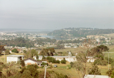 Lakes Entrance Regional Historical Society (operating as Lakes Entrance History Centre & Museum)
Photograph - Township, Fish, Marie, 1985c
Colour photograph of township, showing buildings, Jemmys Point, Mount Barkly, Kalimna Heights, North Arm and old North Arm bridge, and Rigby Island beyond. Sea Vista flats in foreground. Photo taken from near Telecom Tower on Merrangbaur Hill. Lakes Entrance Victoriatopography, township, waterways, bridges -
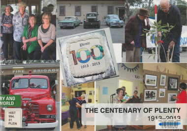 Eltham District Historical Society Inc
Book, The Centenary of Plenty 1913-2013, 2014
Published to commemorate the centenary of the township of Plenty in the Shire of Nillumbik in 2013. It includes photos and information about the centenary celebrations and brief histories of various community groups in Plenty.plenty (vic.), centenary -
 Eltham District Historical Society Inc
Negative - Photograph, J.A. McDonald, Heidelberg-Kinglake Road, Sep. 1960
Looking north from south boundary of St Andrews Township (Cr. Brinkkotter in car) Noted on album page as September 1960 but photo dated October on reverseRecord of various Shire of Eltham infrastructure works undertaken during the period of 1952-1962 involving bridge and road reconstruction projects, sometimes with Eltham Shire Council Project Reference numbers quoted. It was during this period that a number of significant improvements were made to roads and new bridges constructed within the shire that remain in place as of present day (2022). In many situations, the photos provide a tangible visible record of infrastructure that existed throughout the early days of the Shire. The album was put together by or under the direction of the Shire Engineer, J.A. McDonald.infrastructure, shire of eltham, bridge construction, road construction, cr. a. brinkkotter, heidelberg-kinglake road, st andrews, 1960-09 -
 Marysville & District Historical Society
Photograph (Item) - Colour photograph, Unknown
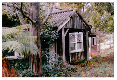
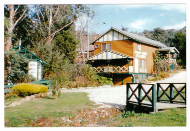
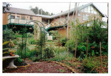
A colour photograph of one of the cottages at Amber View Cottages in Marysville. These cottages, along with most of the buildings within the township, were destroyed in the 2009 Black Saturday bushfires.A colour photograph of one of the cottages at Amber View Cottages in Marysville.amber view cottages, marysville, victoria, australia, accommodation, photograph, 2009 black saturday bushfires -
 Marysville & District Historical Society
Photograph (Item) - Colour photograph, 1986
A colour photograph of the timber worker's cottage that became Arbor Green Cottage in Marysville. This cottage, along with most of the buildings in the township, was destroyed in the 2009 Black Saturday bushfires.A colour photograph of the timber worker's cottage that became Arbor Green Cottage in Marysville.1 Falls Rd M'sville Spring 1986./ Rear cottage./ To become/ Arbor Green Cottage.marysville, victoria, australia, photograph, accommodation, arbor green cottage, 2009 black saturday bushfires -
 Marysville & District Historical Society
Photograph (Item) - Colour photograph, 1986
A colour photograph of the timber worker's cottage that became Arbor Green Cottage in Marysville. This cottage, along with most of the buildings in the township, was destroyed in the 2009 Black Saturday bushfires.A colour photograph of the timber worker's cottage that became Arbor Green Cottage in Marysville.1 Falls Rd M'sville./ Timber workers cottage/ To become Arbor Green Cottage./ Spring 1986.marysville, victoria, australia, photograph, accommodation, arbor green cottage, 2009 black saturday bushfires -
 Marysville & District Historical Society
Photograph (Item) - Colour photograph, Unknown
A colour photograph of the main building and entrance gate to Arbor Green Galleries in Marysville. This cottage, along with most of the buildings in the township, was destroyed in the 2009 Black Saturday bushfires.A colour photograph of the main building and entrance gate to Arbor Green Galleries in Marysville.Arbor Green Galleries./ 1 Falls Rd M'sville./ Side approach.marysville, victoria, australia, photograph, accommodation, arbor green cottage, 2009 black saturday bushfires -
 Marysville & District Historical Society
Photograph (Item) - Colour photograph, Unknown
A colour photograph of the rear of the main building and garden at Arbor Green Galleries in Marysville. This cottage, along with most of the buildings in the township, was destroyed in the 2009 Black Saturday bushfires.A colour photograph of the rear of the main building and garden at Arbor Green Galleries in Marysville.Arbor Green Galleries./ 1 Falls Rd M'sville./ Rear aspectmarysville, victoria, australia, photograph, accommodation, arbor green cottage, 2009 black saturday bushfires -
 Marysville & District Historical Society
Photograph (Item) - Colour photograph, 1986
A colour photograph of the timber worker's cottage that became Arbor Green Cottage in Marysville. This cottage, along with most of the buildings in the township, was destroyed in the 2009 Black Saturday bushfires.A colour photograph of the timber worker's cottage that became Arbor Green Cottage in Marysville.1 Falls Rd M'sville./ Spring 1986./ Timber workers cottage/ To bcome Arbor Green Cottagemarysville, victoria, australia, photograph, accommodation, arbor green cottage, 2009 black saturday bushfires -
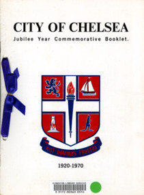 City of Kingston
Booklet - Commemorative book, City of Chelsea, City of Chelsea Jubilee Commemorative Booklet, 1970
In 1920 the City of Chelsea was formally proclaimed to be a city, rather than a township. This booklet, produced in 1970 was to commemorate it being 50 years since Chelsea was proclaimed a city.Five (5) page booklet with white cardboard covering with black text at top and bottom and a blue and red coat of arms for the City of Chelsea in the centre. The book was, at one time, registered with the Kingston Library Service and has a barcode and green sticky dot adhered to the front. There are two holes punched into the left hand side of the booklet with a royal blue ribbon threaded through and connected with a bow.chelsea, proclamation, city -
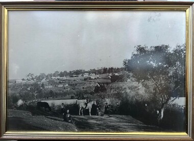 Greensborough Historical Society
Photograph - Photograph (Framed), From Willis Vale to Greensborough 1889, 1889
A view of Greensborough township from Willis Vale, home of the Partington family. Taken on the day of Ellen Whatmough's funeral, this photograph shows both Eva and William Partington.From the John Mackey collection. this item was displayed at the offices of Ryan, Mackey and Kelly, solicitors, Main Street Greensborough.Timber-framed photograph of view of Greensborough, black and white.greensborough, john mackey, partington family, ellen whatmough -
 Eltham District Historical Society Inc
Folder, Short History of the Municipality of Eltham, 1981
Document from unknown author. Sections include: Constitutional history, population growth including ABS data 1943- 1978, notes on the European history of Eltham - about your Council - schools - list of historical buildings. Copy also held at Yarra Plenty Regional Library (Eltham Library). Possibly produced as a resource for students. Also includes single page headed Heritage Week 1983, rural townships, page 3 with refernece to key buildings in Eltham township.30 pages, typed textHG Booklet 17harry gilham collection, pioneers of eltham, population, shire of eltham -
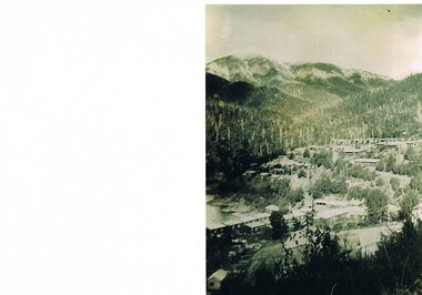 Kiewa Valley Historical Society
Photograph Bogong Township, Bogong Township Circa 1940s right side view, circa 1950
The Bogong Township (circa 1930s) was constructed by The State Electricity Commission of Victoria as a base camp for construction workers under the Kiewa Hydroelectric Scheme starting in 1938. The Scheme employed 4000 men during its construction phase. A small number were first housed at Bogong Village and when required the Mount Beauty Township was established(1949). Construction at the dams and Power Stations was interrupted during World War II. June 1951 started construction at full pace. The Bogong Township was developed firstly as an accommodation centre (base camp) for construction workers employed under the Kiewa Hydroelectric Scheme. Due to the influx of European workers into the Township the beautification of the immediate surrounds(gardens etc.) had a distinct European flavour. This environment has been very beneficial for tourism in later years. Strict environmental control has not allowed for any extensive redevelopment in tourist accommodation and basically restricted it to the accommodation initially built for the construction workers. Activities such a bike riding, snow skiing, restricted horse riding and bush walking on the Alpine plains and mountains are now a viable part of the Kiewa Valley Tourist Industry.Scanned copy of original black and white photo. Paper manufacturer is Kodak. Paper is Kodak XtraLife II.On reverse side "Kodak ExtaLife II paper"bogong village, bogong township, sec alpine constructions, victorian alpine tourism, winter sports. -
 Kiewa Valley Historical Society
Photograph of Kiewa Valley Panorama, Kiewa Valley from No. 5 Road, Before 1945
In 1943 a camp for workmen was erected and a commencement made with the erection of plant storage and workshop buildings in the new township of Mt. Beauty. The photograph was probably taken after the completion of these buildings. There is no sign of construction of the town itself. In the latter part of 1945 work was commenced on the Mt. Beauty township area with a medical centre, general trading store and some houses under construction. The No. 5 Road, from where the photograph was taken, is the road to West Kiewa Power Station and Big Hill Scenic Lookout.Is an excellent view of the Kiewa Valley before there was little work undertaken to establish the town of Mt. Beauty. Farming was well established with the evidence of huge areas of cleared land. The junction of the East and West Kiewa Rivers can be clearly seen. The first Workmen's camp is near the river and some workshop buildings can also be seen. Black and white photograph of the Kiewa Valley, looking North.Handwritten on the back of photograph "Kiewa Valley from No. 5 Road".kiewa valley, camp, buildings, mt. beauty -
Bendigo Historical Society Inc.
Book - KINGOWER 2006
130 page soft cover booklet 'Kingower 2006' A history of the Kingower Township published by the 'Back to Kingower' Committee in 2006 Compiled by Dona Martin and her father Don Walker Edited by Christine Hancock Illustrated with B&W photos of people and places. Donated by Neil Talbot's family 2018Dona Martin & Don Walker -
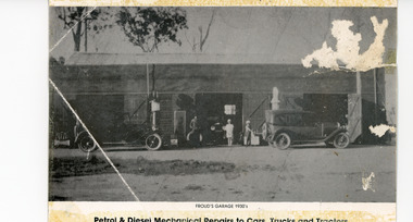 Lakes Entrance Regional Historical Society (operating as Lakes Entrance History Centre & Museum)
Photograph, 1930 c
Appears to have been a promotional postcardBlack and white photograph of Harry (William Henry) Froud's garage situated on Princes Highway in township. Shows two canvas topped motor cars in front of petrol bowsers and another inside the garage, man and girl at doorway, assistant in apron filling petrol tank of one car. Johnsonville VictoriaPetrol and Diesel Mechanical Repairs to Cars, Trucks and Tractorstownship -
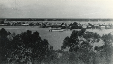 Lakes Entrance Regional Historical Society (operating as Lakes Entrance History Centre & Museum)
Photograph, 1945 c
The Hulk of the Baang Yarnda on the North Arm foreshore. (Note in album)Black and white photograph showing view from Kalimna cliff overlooking North Arm and township, Cunninghame Arm and sand dunes out to Bass Strait. Hulk of old Baang Yarnda moored in North Arm, towed there in 1939 and left to rot. Thick vegetation in foreground. Lakes Entrance Victoria.boats and boating, shipyard -
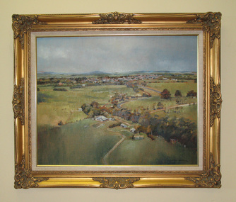 South Gippsland Shire Council
Painting. Oil, Leongatha Landscape
Framed oil painting titled: "Leongatha Landscape" painted by Harris Smith. Features scene of farming property in the foreground and township of Leongatha in the distance. Rolling hills, flora, buildings and sky. Gold decorative frame with cream textured vinyl window mount. Painted in shades of browns, greens, blues and yellows. -
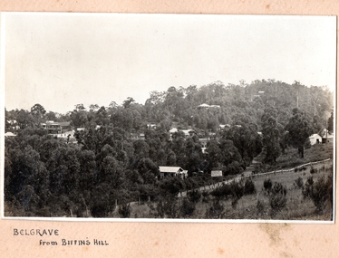 Southern Sherbrooke Historical Society Inc.
Photograph, Belgrave from Biffin's Hill
Photo of Belgrave township from Biffin's Hill (present-day site of Mater Christi School). Road running across front of photo is now Belgrave-Gembrook Rd. There is a sign on the side of the road advertising Biffin Hill Estate for sale. Belgrave main street is visible in background. c. 1920s -
Bendigo Historical Society Inc.
Booklet - Sebastian Back to & School Centenary March 1-2, 1975, Souvenir Booklet
Yellow, soft cover souvenir booklet, 16 pages. 'Sebastian Back to & School Centenary' March 1-2, 1975 B&W photo of Frederick the Great Mine on front cover. Illustrated with B&W photos including the Sebastian Township about 1865 Printed by 'Express' Print, Wedderburnsebastian, centenary -
 Lakes Entrance Regional Historical Society (operating as Lakes Entrance History Centre & Museum)
Postcard, Bulmer, H D, 1940c
One Black and White Photograph 6.5 x 11|Two Postcard 8.5 x 14|Two Small format postcard 6 x 9|This is the before paired photograph used in the 150 year, Lakes Entrance 1858-2008 display.|The after paired photograph number is 01156.1 Also one 12 x 16 framed photograph used in room display.Black and white photographic card of a series of miniature cards used for souvenirs other subject, west side of township, Kalimna Hill, trees, sand hummock views. North Arm bridge and the continuing sealed highway leading around to town. Lying in the distance is the Southern Ocean. Lakes Entrance Victoriatownship, bridges, room display -
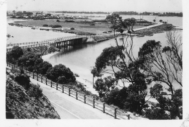
 Eltham District Historical Society Inc
Negative - Photograph, Coghill & Haughton, On the banks of the Plenty, c.1924
Negative copy and associated print of detail from original Sales Brochure: Plenty Township Estate and Bryn Teg Hill's Estate, Coghill & Haughton, Melbourne (c.1924)Roll of 35mm Black and White negative film, 3 strips, (1 of 14 frames) Print 10 x 15 cmFilm - Agfa Ortho 25bridge, bryn teg, bryn teg hill's estate, coghill & haughton, heidelberg golf club hotel, houses, lower plenty, lower plenty bridge, lower plenty road, main road, mrs m thomas, plenty river, plenty township estate, real estate agent, sales brochure -
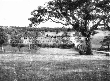
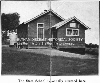 Eltham District Historical Society Inc
Negative - Photograph, Coghill & Haughton, Original Lower Plenty School, c.1924
Negative copy and associated print of detail from original Sales Brochure: Plenty Township Estate and Bryn Teg Hill's Estate, Coghill & Haughton, Melbourne (c.1924)Roll of 35mm Black and White negative film, 3 strips, (1 of 14 frames) Print 10 x 15 cmFilm - Agfa Ortho 25lower plenty, lower plenty state school no. 1295, bryn teg hill's estate, coghill & haughton, sales brochure -
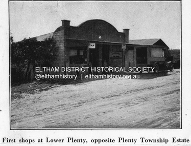 Eltham District Historical Society Inc
Negative - Photograph, Coghill & Haughton, First shops at Lower Plenty opposite Plenty Township Estate, c.1924
Negative copy and associated print of detail from original Sales Brochure: Plenty Township Estate and Bryn Teg Hill's Estate, Coghill & Haughton, Melbourne (c.1924)Roll of 35mm Black and White negative film, 3 strips, (1 of 14 frames) Print 10 x 15 cmFilm - Agfa Ortho 25lower plenty, bryn teg hill's estate, coghill & haughton, sales brochure, main road, plenty-township-estate, shops -
![Negative - Photograph, Coghill & Haughton, A Beautiful Home on the Plenty [Yallambie, Lower Plenty], c.1924](/media/collectors/4f729f7b97f83e03086018a5/items/62365fb2c8228c0f0d9ff3d8/item-media/6600e1625527135282394551/item-fit-380x285.jpg) Eltham District Historical Society Inc
Eltham District Historical Society IncNegative - Photograph, Coghill & Haughton, A Beautiful Home on the Plenty [Yallambie, Lower Plenty], c.1924
Negative copy and associated print of detail from original Sales Brochure: Plenty Township Estate and Bryn Teg Hill's Estate, Coghill & Haughton, Melbourne (c.1924)Roll of 35mm Black and White negative film, 3 strips, (1 of 14 frames) Print 10 x 15 cmFilm - Agfa Ortho 25bryn teg hill's estate, coghill & haughton, sales brochure, houses, lower plenty, plenty-river, yallambie