Showing 2653 items
matching victoria hall
-
 Halls Gap & Grampians Historical Society
Photograph - Sepia
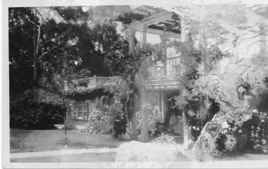
For information on Grampian House, refer to "Victoria's Wonderland" pp. 69-75.Front of Guest House with roses in bloomQuality paper made in Germanyaccommodation, guesthouses, grampian house -
 Halls Gap & Grampians Historical Society
Postcard - B/W
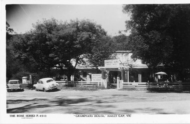
For information on Grampian House, refer to "Victoria's Wonderland" pp. 69-75.Post card of House with cars, women in door way and umbrella outside with tableThe Rose Series P 4513accommodation, guesthouses, grampian house -
 Halls Gap & Grampians Historical Society
Magazine - Photocopy
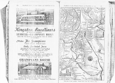
Kingston Roadliners (F. Kingston, Proprietor) STAWELL - GRAMPIANS DAILY Coach for the Grampians meets mid day train at Stawell Return Daily Make the Grampians your next vacation Daily Conducted Tours, from Hotels and Guesthouses in Stawell and Hall's Gap to WONDERLAND - MCKENZIE FALLS - LAKE WARTOOK - MT. VICTORY - MT ROSEA - WANNON VALLEY conducted Hiking Trips Arranged Stawell booking office: 75 Main Street - Phone: Stawell 214, Hall's Gap booking office: Main Road - Phone: Hall's Gap 35, Bookings also from Vitorian Government Tourist Bureau, Cars for hire GRAMPIANS HOUSE The Most Conveniently Situated Tourist House in the Grampians. Ballroom, electric light, large garage, hot water service, hot water in all rooms, internal sewerage. Tennis, fishing, shooting, Alongside is the Bowling Green, where visitors are welcome to play. Phone: Hall's Gap 28. Tariff on application. Manageress: Mrs, E. MatthewsAdvertisement for Kingston Roadliners, Grampians House and Map of the GrampiansAdvertisement in Broadbents, Guide of western Victoria, and South-East of S.A.media, advertisements, grampian house -
 Halls Gap & Grampians Historical Society
Photograph - Photocopy, C 1936
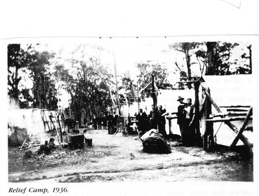
The relief workers as shown in the photograph were used in the Grampians for logging & road maintenance. After the Depression many hundreds of men worked on building and maintaining roads &: tracks. Some were employed by the Forest Commission of Victoria.people, road gang, structures, tents -
 Halls Gap & Grampians Historical Society
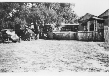
Photograph - B/W, C 1924
Knight's tea-rooms. See "Victoria's Wonderland" p. 103-104 for further information.Photo shows a house with a smaller building behind and a picket fence (house and tea-rooms at Henham. Two cars are parked to the left of the smaller building (tea-rooms)bbuildings, tea rooms -
 Halls Gap & Grampians Historical Society
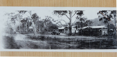
Photograph - B/W, C 1929 - 34
The Knight's Tea-Rooms, which were known as "Coonarah". See "Victoria's Wonderland" p. 103-104 for further information.Photo shows a house with a smaller building to the right (Knight's tea-rooms at the Wannon).There is a car parked in front of the house and an unsealed road runs through the foreground.buildings, tea rooms -
 Halls Gap & Grampians Historical Society
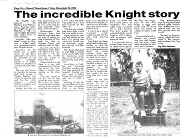
Newspaper - B/W, 29/12/2000
This is a newspaper article about the Knight family. It was written by Ida Stanton for the Stawell Times-News "Halls Gap Extra" and was published on Friday, 29 December 2000, p.16. The photos included in the article are C 1881. For more information see "Victoria's Wonderland", "Water between the hills".A newspaper article headed "The Incredible Knight story", containing two photos. The photos are of a couple (Gus and Ellen Knight) in a Stanley Steamer car; and two boys (Bert and Ken Knight) sitting on a pile of boxes with a small dog in the foreground. They are wearing shoes made from rubber tubes.people, knight -
 Halls Gap & Grampians Historical Society
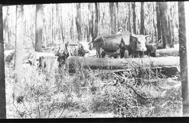
Photograph - B/W, C 1910
The photo is of an unknown bullock team in the Grampians. Note: The photo may have been taken by Guy E. Neate of "Rosebank" on Neates Road in the Victoria Valley, however Guy Neate did not buy that property until June 1926 (see the book "Water Between the Hills".The photo shows a team of bullocks surrounded by logs in a clearing in the bush. A man is just visible behind the bullocks.timber industries, logging, transport, bullock team -
 Halls Gap & Grampians Historical Society
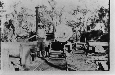
Photograph - B/W, C 1910
The photo shows a timber mill in the Grampians. Neither the location nor the people are known. Note: The photo may have been taken by Guy E. Neate of "Rosebank" on Neates Road in the Victoria Valley, however Guy Neate did not buy that property until June 1926 (see the book "Water Between the Hills".The photo shows two men standing beside a trolley with a large log on it. There are other logs to the left and some sawn wood is visible stacked towards the back.timber industries, logging, sawmilling -
 Halls Gap & Grampians Historical Society
Photograph - B/W, C 1960s
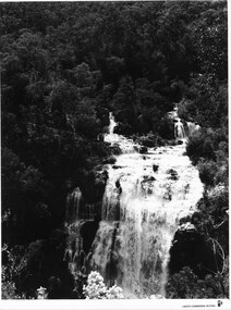
A Forestry Commission photo of MacKenzie Falls.Photo shows a large waterfall (MacKenzie Falls), taken from a fairly high vantage point. The river comes into the falls in two separate streams and there is a large volume of water flowing. The falls are surrounded by thick bush."Publicity & Public Relations branch. When reproducing please Acknowledge FORESTS COMMISSION, VICTORIA. Negative No. 322-2" stamped on rear (except negative number, which is hand written in pen)scenery, mackenzie falls -
 Halls Gap & Grampians Historical Society
Photograph - B/W, C 1960s
This photo was taken in the Mt William area and was material for a Ministry of Tourism campaign.The photo shows a man seated on a rock and looking out over a valley (Mt William area, south west)'This Photograph is with, The Compliments of The . . . ,Ministry of Tourism, Government of Victoria, Please acknowledge, Photo: Michael Chesire' stamped on back. 'Grampians Mt. William' written on back in red pen.scenery, mount william -
 Halls Gap & Grampians Historical Society
Photograph - B/W, C 1960s
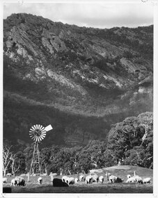
This photo was taken at the foot of the range at Glen Isla. It was material for a Ministry of Tourism campaign.The photo shows sheep grazing in a cleared area with a rocky range rising behind. There is a wind mill in the left foreground and a fence behind the front group of sheep.'This Photograph is with, The Compliments of The . . . ,Ministry of Tourism, Government of Victoria, Please acknowledge, Photo: Michael Chesire' stamped on back. 'Glen Isla, Grampians' written on back in black pen.scenery, grampians ranges -
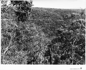
 Halls Gap & Grampians Historical Society
Photograph - B/W, C 1960s
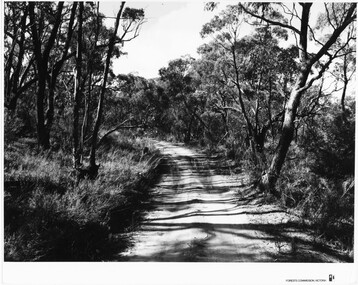
Location unknown.The photo shows a sandy track through bushland.'Forests Commission, Victoria' inscribed on bottom, right of border. 'Publicity & Public relations Branch, When reproducing please Acknowledge Forests Commission, Victoria, Negative No. 322-14' stamped on back.access routes, roads, scenery, grampians ranges -
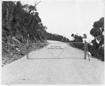 Halls Gap & Grampians Historical Society
Photograph - B/W, C 1960s (?)
A photo of the gate barring vehicle access to the top portion of the Mt William Road. The photo is part of a Ministry of Tourism campaign.The photo shows an iron gate across a road (Mt William Road). There is a man standing on the edge of the road in the background. A sign on the gate reads 'No vehicles beyond this point'.'Ministry of Tourism of Victoria, 276 Collins St., Melbourne, Nag. No.... , Date ..., Locality Grampians, Subject Gate-Mount William Road.' stamped on back.access routes, roads, scenery, mount william -
 Halls Gap & Grampians Historical Society
Photograph - B/W, C 1960s (?)
The location in the photo is unknown.The photo shows a road, seen on a slope, in the distance, crossing through bushland'Forests Commission, Victoria' inscribed on bottom, right of border. 'Publicity & Public relations Branch, When reproducing please Acknowledge Forests Commission, Victoria, Negative No. 322-1' stamped on back.access routes, roads, scenery, grampians ranges -
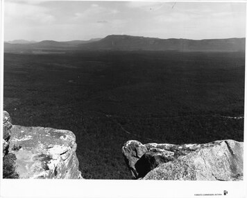 Halls Gap & Grampians Historical Society
Photograph - B/W, C 1960s (?)
The photo is taken from Reed's Lookout.The photo shows the view across a valley from a (Reed's Lookout). The foreground is two large rock platforms. A reservoir (Moora Moora) and ranges can be seen in the background. Roads can be seen in the valley in the foreground.'Forests Commission, Victoria' inscribed on bottom, right of border. 'Publicity & Public relations Branch, When reproducing please Acknowledge Forests Commission, Victoria, Negative No. 322-23' stamped on back.scenery, lookouts -
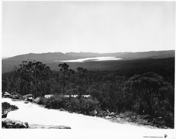 Halls Gap & Grampians Historical Society
Photograph - B/W, C 1960s (?)
This photo is a view from the road at Reed's Lookout.The photo shows the view from beside a road (the road at Reed's Lookout), across bushland to a large reservoir (Lake Wartook). There is a range of peaks in the background. The road forms the foreground.'Forests Commission, Victoria' inscribed on bottom, right of border. 'Publicity & Public relations Branch, When reproducing please Acknowledge Forests Commission, Victoria, Negative No. 322-34' stamped on back.scenery, lookouts -
 Halls Gap & Grampians Historical Society
Photograph, C 1920s
This is a photo of the Mt. Victory Road under construction. The workers camp can be seen in front of the road. For further information see 'Victoria's Wonderland', pp 102, 112 & 136. Note: The second copy is a transparency held at Slide Box No. 162.The photo shows a slope covered in thick bush. A road can just be seen in the middle foreground and a campsite with many tents can be seen through the bush in front of the road.access routes, mt victory rd -
 Halls Gap & Grampians Historical Society
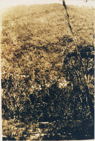
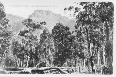
Photograph - B/W
From the inscription "V.G. 259" it would appear that this copy was made by the Victorian Government. It is a photo of Wonderland Peak.The photo shows a rocky range rising behind eucalyptus trees. There is a fallen log in the left foreground."Wonderland Peak, The Grampians, Victoria" inscribed on top left, and "V.G. 259" inscibed on lower left, of copy 1. These have been cropped out on copy 2.scenery, wonderland range -
 Halls Gap & Grampians Historical Society
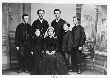
Photograph - B/W, C 1830
This is a portrait of Robert Graham's family. For further information about Robert Graham see "Victoria's Wonderland", pp 61-68 & 121.The photo shows a portrait of one woman (seated), two men at the back, three boys flanking the men and a young girl standing behind and to the right (photo left) of the woman.people, graham -
 Halls Gap & Grampians Historical Society
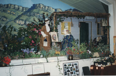
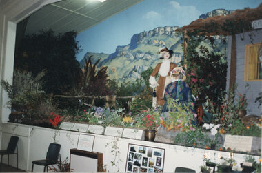
Photograph - Coloured, 06/11/1992
This display at the 1992 Wildflower Show in the Halls Gap Hall replicated the D'Alton home "Glenbower". The seated mannequin represents Henrietta D'Alton (artist) and the standing mannequin represents Ellen D'Alton. For further information about "Glenbower" and the Misses D'Alton see "Victoria's Wonderland", pp 79 & 123. ** the two copies are also originals, the third original is a slightly closer view of the display.The photo shows a stage display - a house has been set up to replicate "Glenbower". Two mannequins dressed in period costume are in front of the house, one standing and one seated at a table. A flower garden has been created around the scene and a mural showing rocky peaks can be seen in the background. The front of a stage with another display can be seen in the foreground."92 6 11" imprinted into bottom, right corner of photo.events, wildflower show -
 Halls Gap & Grampians Historical Society
Photograph - Coloured, 06/11/1992
This display at the 1992 Wildflower Show in the Halls Gap Hall replicated the D'Alton home "Glenbower". The seated mannequin represents Henrietta D'Alton (artist) and the standing mannequin represents Ellen D'Alton. For further information about "Glenbower" and the Misses D'Alton see "Victoria's Wonderland", pp 79 & 123. ** copy is actually a second original from a slightly different angle.The photo shows a stage display - a house can be seen on the right - set up to replicate "Glenbower". Two mannequins dressed in period costume are in front of the house, one standing and one seated at a table. A flower garden has been created around the scene and a mural showing rocky peaks can be seen in the background. The front of a stage with another display and two grey chairs can be seen in the foreground."92 6 11" imprinted into bottom, right corner of photo.events, wildflower show -
 Halls Gap & Grampians Historical Society
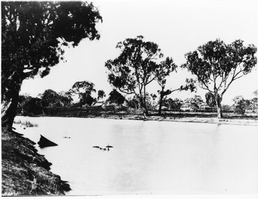
Photograph - B/W, c 1844
This property was known as Mokepilly Station ( name on back of photo is spelt 'Mokepilli'.For further reference see p.2,p.92,116,119,121, Victoria's Wonderland.Photo shows a body of water in foreground with a collection of buildings on opposite bank. there are a number of large gum trees on both sides of water. The buildings appear to be a farmhouse and outbuildings that have thatched roofs. There is extensive fencing.buildings, houses -
 Halls Gap & Grampians Historical Society
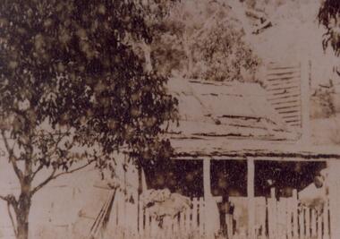
Photograph - Sepia, c 1876
Cottage is said to be that of Foulkes family. The cottage was situated below Mackey's Peak in the Fyans Valley. See p.77 Victoria's Wonderland.Photo shows old house with verandah enclosed with pickets. Two gum trees can be seen either side of houses. Vegetation, either a garden or grass is growing in front of verandah. An old door or doors are leaning against left side of house.buildings, houses -
 Halls Gap & Grampians Historical Society
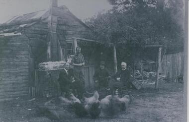
Photograph - B/W
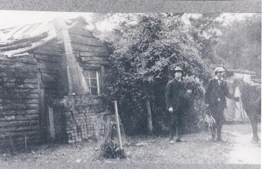
Fred Paasch was born in Denmark in 1862. It is unknown when he arrived in Australia or when he settled in Halls Gap. He owned land generally in the area now occupied by the Halls Gap Supermarket where he established an orchard. See " Bridging the Gap " p.58-60 "Victoria's Wonderland" p.98-99.Shingle and slab house, chimney has loose brick base and tin flue. Four men in foreground. Freddy Paasch, owner of the house is seated in the centre. A number of hens feed in the near foreground. A climbing rose coyers the fence and part of the house roof.buildings, houses, people, paasch -
 Halls Gap & Grampians Historical Society
Photograph - B/W
Frederick Paasch 's house with two Chandlers outside. See Victoria's Wonderland p98-99. Weather board slab building with climbing rose growing on side of house. Bricks form base of chimney with an iron flue forming rest of chimney. Two men and a horse stand to the right of the cottage.buildings, houses -
 Halls Gap & Grampians Historical Society
Photograph - B/W
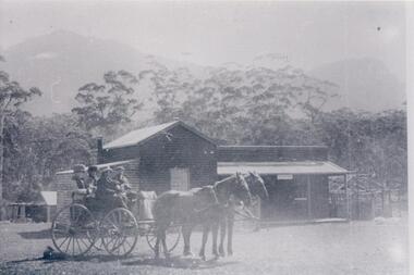
c Early 1900's. Borough Huts were originally used to house the workers for the Stawell Water Supply system, later used for holiday accommodation. For Further information see " Victoria's Wonderland p37,63,79-80,93,107.Four people sitting in a dray, two men in the front and two ladies in the back. Two horses are in the traces. They are in front of a weather board building with a galvanised iron roof, a veranda runs along the front of the building. Tall gum trees are behind the building, a mountain range can be seen vaguely in the background.water supplies, borough huts, buildings, shops -
 Halls Gap & Grampians Historical Society
Photograph - B/W, C 1876
This cottage is said to have belonged to the Foulkes family. It was situated below Mackey's peak in the Fyans Valley. For further information see p. 77 of "Victoria's Wonderland".The photo shows a timber house and outbuilding set among bush below a line of cliffs. There is a spoked wheeled cart standing to the right of the house. The buildings are in the foreground at the lower edge of the photo.buildings, houses -
 Halls Gap & Grampians Historical Society
Postcard - Coloured
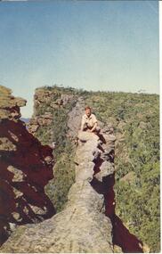
The "Nerve Test" with Bellfield Peak beyond,the Grampians, Victoria. Postcard by Nuclorvue Productions Pty. Ltd.Young man crouched on top of narrow rocky outcrop, mountains in background,steep ravines on either side.Postcard/letter no date except Tuesday,7th.scenery, grampians ranges -
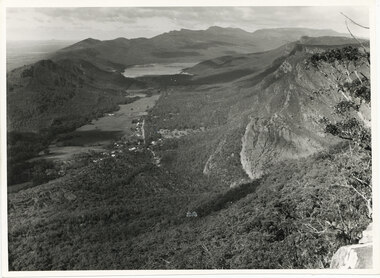 Halls Gap & Grampians Historical Society
Photograph - B/W
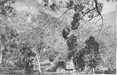
The photo is of the Fyans Valley, taken from Chatauqua Peak. Lake Bellfield and Mount William can be seen in the background. The photo belonged to the Forestry Commission Victoria.A photo of a valley between mountain ranges. A lake can be seen in the background. A road runs through the middle of the valley with houses on both sides."Fyans Vaslley from Chataqua Peak. Incl L. Bellfield & Halls Gap. photo belongs to F.C.V. Stawell. Return to V. Young, Horsham" written on back in green pencil. The "Chatauqua Peak" has been overwritten in black-lead pencil. "LC.71" is also written on the back in black-lead pencil.scenery, grampians ranges