Showing 14942 items
matching view-finder
-
 Greensborough Historical Society
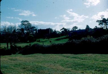
Photograph - Digital Image, View of Greensborough near Blackjack, 1954_
View of Greensborough near Blackjack. The Blackjack property, house and acres of fruit orchards ran down to the Plenty River off Hume Street Greensborough and was the home of the Robinson family to late 1956. The photographs were taken as slides by Frank Robinson and digitised by his son James in 2015.Digital copy of colour photograph.robinson family, blackjack -
 Greensborough Historical Society
Photograph - Digital Image, View of Blackjack near Greensborough, 1954_
View of Blackjack near Greensborough. The Blackjack property, house and acres of fruit orchards ran down to the Plenty River off Hume Street Greensborough and was the home of the Robinson family to late 1956. The photographs were taken as slides by Frank Robinson and digitised by his son James in 2015.Digital copy of colour photograph.robinson family, blackjack -
 Mt Dandenong & District Historical Society Inc.
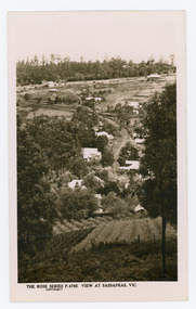
Photograph, View at Sassafras, Vic, c1930
View down the Main Street of Sassafras looking south with the Mechanics Institute in the centre of the picture. The raspberry patch in the foreground belonged to Woniger Hansen who built Mountain Rest (Rostrevor). The land was subdivided after his death in 1923. The raspberry patch is in the area of the current Mason Grove.Black and white Rose Series postcard P. 4765 looking south down the Main Street of Sassafras with buildings either side and berry patches in the foreground.On reverse POST CARD. THE "ROSE' SERIES DELUXE. A REAL PHOTOGRAPH PRODUCED IN AUSTRALIA. PUBLISHED BY 'THE ROSE STENOGRAPHS" Armadale. Victoria sassafras, rose series, rostrevor, woniger hansen, hansen, mechanics' institute, raspberry, raspberry crop, mountain rest, mason grove -
 Vision Australia
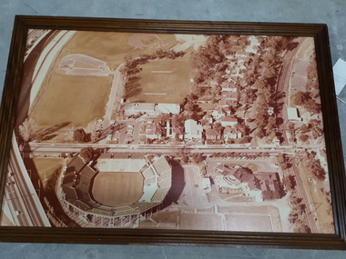
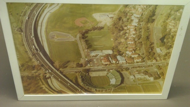
Photograph - Image, Association for the Blind offices in Kooyong aerial view
Aerial view of Kooyong. The Kooyong Tennis Centre, Glenferrie Road, train station, Talbot Crescent, Monash Freeway and parklands are clearly visible. Few trees are lining the roadway around the sporting fields, the Glenferrie Road building has not expanded and the Blind Cricket pavilion is not yet built. Aerial photograph in brown frame.association for the blind, kooyong tennis centre -
 Vision Australia
Photograph - Image, Association for the Blind offices in Kooyong aerial view
Aerial view of Kooyong. The Kooyong Tennis Centre, Glenferrie Road, train station, Talbot Crescent, Monash Freeway and parklands are clearly visible. Few trees are lining the roadway around the sporting fields, the Glenferrie Road building has not expanded and the Blind Cricket pavilion is not yet built. Aerial photograph in white frameassociation for the blind, kooyong tennis centre -
 Greensborough Historical Society
Photograph - Digital image, Jasmin Burge, View of grounds, Loyola College 2012, 19/06/2012
View of grounds, Loyola College 2012. Part of a collection of photographs of Loyola College, Grimshaw Street Watsonia, established 1980 on the site of the Loyola Seminary. The College purchased the original building in 2002. These photographs of the original building and grounds were taken by GHS member Jazz Burge in June 2012.Digital copy of colour photograph.loyola college -
 Mt Dandenong & District Historical Society Inc.
Photograph, View From Ernest Road To Site Of "Kia-Ora"
John Lundy-Clarke grew up in the Kalorama/Mt Dandenong area and later in life (1972-74) began to write a comprehensive history of the area working from an original settlement map in an effort to cover all areas. The photograph taken c1973 from Ernest Road looks over the site of the Kia-Ora guesthouse which is marked by the oalm tree that can be seen at the front of the flat roof close to the gum tree trunk. Situated on Barber’s Road, ‘Kia-Ora’ was built in 1912 by George Barber. It was later leased by a Mrs Pemberthy. “Kia-Ora’ was one of four places connected when the telephone was brought into the district in 1912. The other places were ‘Mountjoy’, ‘Cherry Farm’ and ‘Callum House’. ‘Kia-Ora’ was burnt down in 1924.Black and white photograph showing a house with water tank in right foreground and another flat roof centre foreground. There is a handwritten description by John Lundy-Clarke on the reverse.View 1973 from corner of Ernest Rd and Outlook Drive Lot 24 Village Settlement looking over the site of “Kia Ora” to the pioneers clearings. The palm tree seen above the flat roof (Rex) on left, is on the exact site of “Kia Ora”. Photo JLCernest road, john lundy-clarke, kia=ors, guest house, guesthouse -
 Greensborough Historical Society
Photograph - Digital image, Jasmin Burge, Loyola: garden view from tower 2012, 19/06/2012
Loyola: garden view from tower 2012. Part of a collection of photographs of Loyola College, Grimshaw Street Watsonia, established 1980 on the site of the Loyola Seminary. The College purchased the original building in 2002. These photographs of the original building and grounds were taken by GHS member Jazz Burge in June 2012.Digital copy of colour photograph.loyola college -
 Greensborough Historical Society
Photograph - Digital image, Jasmin Burge, Loyola: distant view from tower 2012, 19/06/2012
Loyola: distant view from tower 2012. Part of a collection of photographs of Loyola College, Grimshaw Street Watsonia, established 1980 on the site of the Loyola Seminary. The College purchased the original building in 2002. These photographs of the original building and grounds were taken by GHS member Jazz Burge in June 2012.Digital copy of colour photograph.loyola college -
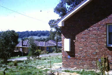 Greensborough Historical Society
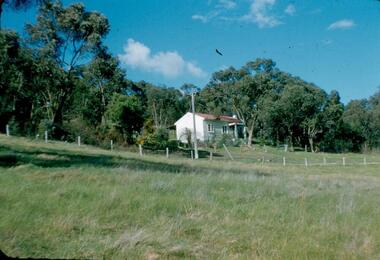
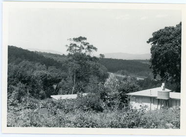
Photograph - Digital Image, View from Flodden Way Briar Hill, 1966-1969
View from Flodden Way, looking across to the next ridge. "I remember a row of houses being burnt beyond that ridge at Diamond Creek and having ash inside our home." The Noone family lived at 1 Flodden Way from 1966 to 1969. Caption by Julie Noone 2017.Shows the development of the area in the 1960s.Digital copy of colour photograph, taken from photographic slide.flodden way briar hill -
 Ringwood and District Historical Society
Photographs, Construction Stage of historical Miner's Cottage Museum completed 1983, and panoramic view of partial construction of commercial buildings on former Ringwood Market site, Seymour Street, Ringwood c.1970s. On cardboard
3964/1 15 photographs on cardboard 76cmX51cm depicting construction stages of historical Miner's Cottage Museum completed 1983; 3964/2 4 photographs on cardboard 85.5cmX22.5cm forming panoramic view of partial construction of commercial buildings on former Ringwood Market site, Seymour Street, Ringwood c.1970s -
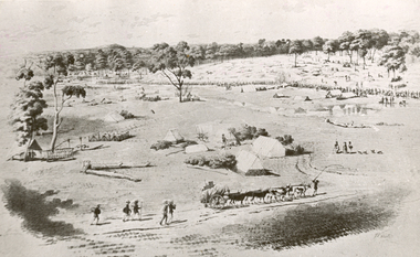 Federation University Historical Collection
Photograph - Photograph - black and white, William Strutt, View of Golden Point, Ballarat, Taken from West
The lithograph is held by the State Library of Victoria. Printed below the image is Lithographed by Campbell & Macartney. The title is beneath image and continues: 'Respectfully dedicated to the inhabitants of Victoria / By their obedient servant / Wm. Strutt.'Photograph of a lithograph of view of the Golden Point - Ballarat by William Strutt. The Golden Point goldfield at Ballarat is depicted with a number of people congregated along a creek (Yarrowee Creek), some tents, stockyards evident, a butcher's shambles (tent) a bullock dray, three aborigines and a number of 'diggers' walking towards the goldfield are evident.ballarat, golden point, william strutt, ballarat townscape, mining, goldfield -
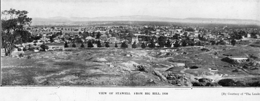
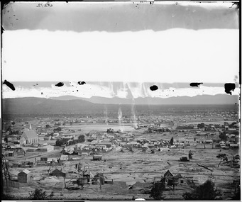 Stawell Historical Society Inc
Photograph, View of Stawell from Big Hill April 1874 showing mines centered on St Georges Crushing Mill -- 5 Photos
From left Reefs Restaurant, T. Hogan & Co Tea Wine Spirits Merchant, R. Hepburn Carolina Hotel, Pleasant Creek Hotel, St George Stamping Battery, Free Methodist Chapel Church, Ballarat Hotel, Woodcock Produce Grocer, Stawell Brewery in far distance, L. Thomas Wheelwright Farrier & General Blacksmith, Australian Hotel, G. Laing Bootmaker, Brierly & Wilson Greengrocer, P. Corkeron Bootmaker, P. Corkeron Wholesale Retail General Grocer, Globe Hotel in distance, Christ Church.Part of Holtermann Collection. Black and White photograph of Stawell from Big Hill with mining in foreground. April 1874. View covers from St Patrick's Church to current location of Police Station along Patrick Street. St George Crushing Mill near Centre of Photograph. Includes Carolina Hotelmining, panorama -
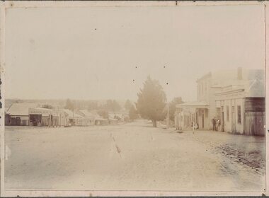 Linton and District Historical Society Inc
Photograph, Sussex Street, Linton, View to south-west, circa 1900
Shops on the left of the picture are: saddler (probably O'Sullivan at this time), butcher (probably G G Bennett), baker's shop (Nicol?), shop with verandah (originally 'Ellington House' owned by T M Wise), Preston's shop (with verandah, on corner of Sussex & Gillespie Streets), and Wishart's blacksmiths (on the far side of Gillespie Street). On the right, the buildings are E H Nicholls ("cheap grocer and seedsman"), the Surface Hill Hotel, Richard Ching's store and dwelling (grocer & produce merchant), and another shop without verandah (probably shop and dwelling owned by Annie Brown, née Nicholls).Original black and white photograph affixed to white backing paper which has then been mounted on grey card. The photograph shows the view along Sussex Street to the south-west. Two men are standing outside a shop on the rhs, and there appears to be a woman with a perambulator outside a building further along the street on the rhs.On back of original photograph: "g (or e) Bennett" (in blue pencil or chalk) / "LINTON STREET "(in ink) / "Elizabeth long ago" (in ink, with arrow pointing to blue writing).sussex street linton, o'sullivan's saddlery, g g bennett's butcher shop, nicol's bakery, ellington house [t m wise draper], preston's shop, wishart's blacksmiths, e h nicholls' store, surface hill hotel, richard ching's store, annie brown's shop, annie brown (née nicholls) -
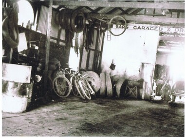 Greensborough Historical Society
Photograph - Digital image, Stubley Garage - Interior View 1946, 1946_
Interior view of Stubley Motors 1946. The Stubley Group began in 1946 when Purcell Stubley purchased a site with petrol bowsers in Main Street from 'Snowy' Jessop. In 1948 Purcell began building the new Stubley Motors, working round the old site to keep the business operating. It was completed in 1951.Digital copy of black and white photographpurcell stubley, stubley motors -
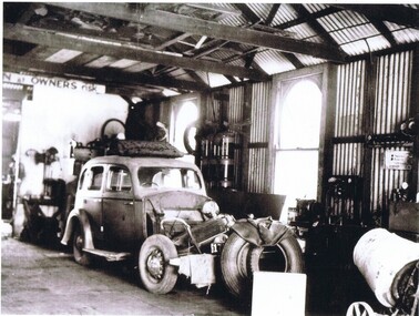 Greensborough Historical Society
Photograph - Digital image, Stubley Garage - Interior View 1946, 1946_
Interior view of Stubley Motors 1946. The Stubley Group began in 1946 when Purcell Stubley purchased a site with petrol bowsers in Main Street from 'Snowy' Jessop. In 1948 Purcell began building the new Stubley Motors, working round the old site to keep the business operating. It was completed in 1951.Digital copy of black and white photographpurcell stubley, stubley motors, stubley group greensborough -
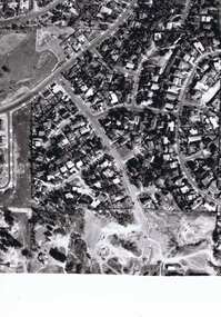 Greensborough Historical Society
Photograph - Digital image, Frank Solomon, Pig Farm, Weidlich Road area: aerial view, 02/08/2009
An aerial view of the pig farm in Weidlich Road Greensborough, owned by Werner Hanusch. The land was used as a pig farm and quarry from 1954 and has now been subdivided into the Evelyn Way estate. This project of fifty, one double storey, dwellings was commenced on 2/8/2009 and completed on 6/2/2011.An example of the changing land use in Greensborough, from farming to residential.Digital copy of aerial photographwerner otto fritz hanusch, pig farm st helena, weidlich road greensborough, one evelyn way greensborough -
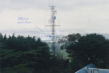 Eltham District Historical Society Inc
Photograph, View of communications tower from War Memorial tower, Kangaroo Ground, July 1998
Handwritten sketches showing additions to the Police/Emergency services communications tower in 2004. Harry Gilham noted that the cylindrical shaped object was blocking the view from the War Memorial tower to the land area and made suggestions to the Nillumbik Shire Council and CFA that it be raised to the sky area above the Mt St Leonard-Healesville range.Colour photo print 12.5 x 19 cmHandwritten notes on both sides regarding 2004 modificationskangaroo ground, shire of eltham memorial park, emergency services communications tower, harry gilham, nillumbik shire council, war memorial tower -
 Greensborough Historical Society
Photograph - Digital image, Marilyn Smith et al, Janefield Precinct: more pondering - Janefield view, 27/11/2014
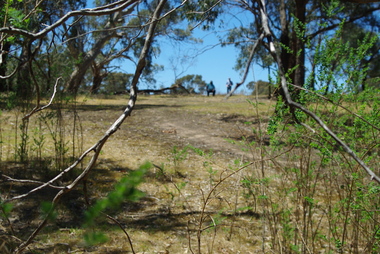
More pondering - Janefield view. The remains of this site are between Greensborough and Janefield. A RAAF Hygiene Training Camp was located on the Plenty River, just south of the Janefield community. It was in use from 1944 to 1946. The Camp was constructed from salvaged materials. Instruction included building and maintenance of grease traps, latrines, elementary plumbing and carpentry.Early remains of a WW2 training camp Digital colour photograph. -
 Greensborough Historical Society
Photograph - Digital image, Marilyn Smith et al, Janefield Precinct view November 2014, 27/11/2014
View of the Janefield Precinct taken November 2014. The remains of this site are between Greensborough and Janefield. A RAAF Hygiene Training Camp was located on the Plenty River, just south of the Janefield community. It was in use from 1944 to 1946. The Camp was constructed from salvaged materials. Instruction included building and maintenance of grease traps, latrines, elementary plumbing and carpentry.Early remains of a WW2 training campDigital colour photograph.janefield, raaf hygiene training camp janefield -
 Greensborough Historical Society
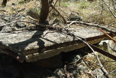
Photograph - Digital image, Marilyn Smith et al, Janefield Precinct: Side view showing reinforcements, 27/11/2014
Janefield Precinct: Side view showing reinforcements. The remains of this site are between Greensborough and Janefield. A RAAF Hygiene Training Camp was located on the Plenty River, just south of the Janefield community. It was in use from 1944 to 1946. The Camp was constructed from salvaged materials. Instruction included building and maintenance of grease traps, latrines, elementary plumbing and carpentry.Early remains of a WW2 training camp Digital colour photograph. -
 Greensborough Historical Society
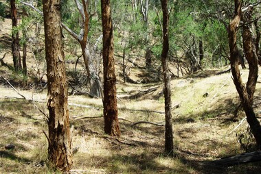
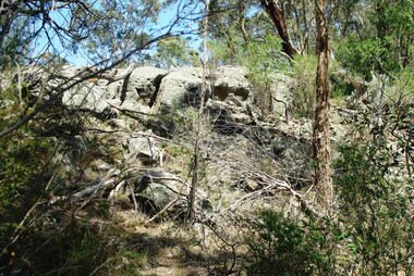
Photograph - Digital image, Marilyn Smith et al, Janefield Precinct: View of edge of basalt flow, 27/11/2014
Janefield Precinct: View of edge of basalt flow. The remains of this site are between Greensborough and Janefield. A RAAF Hygiene Training Camp was located on the Plenty River, just south of the Janefield community. It was in use from 1944 to 1946. The Camp was constructed from salvaged materials. Instruction included building and maintenance of grease traps, latrines, elementary plumbing and carpentry.Early remains of a WW2 training camp Digital colour photograph.janefield -
 Greensborough Historical Society
Photograph - Digital image, Marilyn Smith et al, Janefield Precinct: View of river bend, 27/11/2014
Janefield Precinct: View of river bend. The remains of this site are between Greensborough and Janefield. A RAAF Hygiene Training Camp was located on the Plenty River, just south of the Janefield community. It was in use from 1944 to 1946. The Camp was constructed from salvaged materials. Instruction included building and maintenance of grease traps, latrines, elementary plumbing and carpentry.Early remains of a WW2 training camp Digital colour photograph.janefield -
 Eltham District Historical Society Inc
Photograph, Side view of Shillinglaw Cottage
Side view of 'Shillllinglaw Cottage' in its original location on Main Road Eltham, 1964. The cottage was built by George Stebbings about 1859 and is made from hand made bricks laid in a Flemish bond pattern. In the 1960s it was marked for demolition to make way for the construction of new council buildings but a community campaign saved the cottage and it was re-located.Shillinglaw Cottage is itself historically, aesthetically and socially significant to the Shire of Nillumbik and is registered on the Victorian Heritage Database. This photo forms part of a collection of photographs gathered by the Shire of Eltham for their centenary project book, "Pioneers and Painters: 100 years of the Shire of Eltham" by Alan Marshall (1971). The collection of over 500 images is held in partnership between Eltham District Historical Society and Yarra Plenty Regional Library (Eltham Library) and is now formally known as 'The Shire of Eltham Pioneers Photograph Collection.' It is significant in being the first community sourced collection representing the places and people of the Shire's first one hundred years.Digital imagesepp, shire of eltham pioneers photograph collection, eltham, shillinglaw cottage -
 Stawell Historical Society Inc
Photograph, Panorama of Stawell from Big Hill c 1930
Panorama of Stawell from Big Hill, Looking at Patrick Street. Grampians in Background Views from Big Hill 1930 showing remnants of mining. Visible Kinsella House Patrick Street, Stawell Court House, Hotel Patrick Street, Upper end of Main StreetTwo identical paper print views of Stawell from Big Hill, taken in 1930 courtesy of "The Leader". View of Stawell From Big Hill 1930 [By Courtesy of "The Leader'stawell, panorama, mining, streetscape -
 Eltham District Historical Society Inc
Photograph, View at Eltham, Vic, c.1924
Copy of possible Rose Stereograph Co. postcard “View at Eltham, Vic.”, c.1924 looking southwest from Main Road near York Street to Bridge Street and the original 1875 bridge across what is now the Alistair Knox Park The land in the foreground was first bought from the Crown by J.M. Holloway in 1851. The land was sub-divided and called "Little Eltham". Bridge Street was created as part of the sub-division. Most of the sub-division was residential lots but the creek valley was divided into lots for small farms. Council started to buy the land for the Eltham Town park in the early 1960s. The area was used as a garbage tip and filled above the flood plain of the creek. Development of the land for a park began in the early 1970s. The house on the right was owned for many years by the Hill family until Council bought it in the early 1960s. The house was built in the 1850s or 60s. The house on the left stood on what is now the southwest corner of Susan and Bridge Streets. The Braithwaite family was associated with this house. The double line of fencing in the foreground was a continuation of York Street to the creek. The Bridge Street bridge was built in 1875 and replaced in 1958. (Ref: Early view of Little Eltham; Byways of History by Colleen Ison, Publication unk, 24 August 1982) Reproduced on p61 of 'Pioneers & Painters' Date estimated on same as View at Hurstbridge featuring Wattle Valley EstateThis photo forms part of a collection of photographs gathered by the Shire of Eltham for their centenary project book,"Pioneers and Painters: 100 years of the Shire of Eltham" by Alan Marshall (1971). The collection of over 500 images is held in partnership between Eltham District Historical Society and Yarra Plenty Regional Library (Eltham Library) and is now formally known as the 'The Shire of Eltham Pioneers Photograph Collection.' It is significant in being the first community sourced collection representing the places and people of the Shire's first one hundred years.Digital image 120 format B&W negative Prints 17 x 25 cm and 10 x 15 cmsepp, shire of eltham pioneers photograph collection, eltham, bridge street, bridge, alistair knox park, braithwaite, bridge street bridge, eltham town park, hill family home, main road, pioneers and painters, york street -
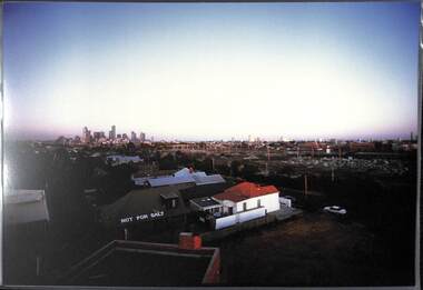 Port Melbourne Historical & Preservation Society
Photograph, James Lauritz, View towards city showing protest "Not For Sale" on roof, 1989 - 1990
View towards city showing protest "Not For Sale" on roof. House belonged to Senator Olive Zakharov who won the battle against compulsory acquisition. Photo is taken from the roof of the Mission to Seamen. City is in background James Lauritz print of Port Melbourne, laminated (one of 18). Copies of slides produced for Port Melbourne Councillocal government - city of port melbourne, built environment, james lauritz, olive zakharov -
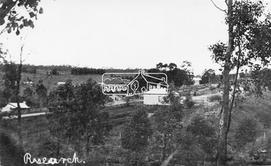 Eltham District Historical Society Inc
Negative - Photograph, Tom Prior, View of Research, Vic, c.1900
View of Research looking down Ingrams Road towards the rear of Doney's store, Main Road left to right. General Store centre. Ingrams Road opposite General Store. Hotel right of centre. The small building at left of photo housed the school for a short period of time but it was too hot in summer and the community lobbied for a more substantial school.This photo forms part of a collection of photographs gathered by the Shire of Eltham for their centenary project book,"Pioneers and Painters: 100 years of the Shire of Eltham" by Alan Marshall (1971). The collection of over 500 images is held in partnership between Eltham District Historical Society and Yarra Plenty Regional Library (Eltham Library) and is now formally known as the 'The Shire of Eltham Pioneers Photograph Collection.' It is significant in being the first community sourced collection representing the places and people of the Shire's first one hundred years. The Reynolds family were early settlers in Research. The Reynolds/ Prior collection of photographs were taken by Tom Prior, the maternal uncle of Ivy Reynolds, around 1900 and the 60 photos in the album give a fine overview of many of the landmarks of Research and Eltham over 100 years ago. lvy lived in the family home for many years at 106 Thompson Cres Research. Ivy's father, Ernst Richard Reynolds and grandfather, Richard Reynolds, lived at the same address. Ivy's father Richard worked for Mr. Trail on his property in Research. Reynolds Road is named after the family. Mr Tom Prior (wife Eva) worked at the Melbourne zoo. He was very innovative and made his own camera, using the black cloth hood to exclude the light. The photographs are a reminder of the rural nature of Research and Eltham and its rich heritage.Digital image 120 format B&W negativesepp, shire of eltham pioneers photograph collection, research (vic.), general store, ingrams road, main road, research hotel, doney property, research primary school, reynolds prior collection -
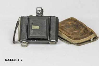 Whitehorse Historical Society Inc.
Equipment - Camera ZEISS IKON, 1930
The camera was owned by the donor and her father. They were bushwalkers and took many photos on their walks.Small black oblong camera with fold down view finder and fold out bellows with 7.5cm lens. Camera folds into well worn leather case.IKONTAphotography, cameras -
 Mt Dandenong & District Historical Society Inc.
Photograph, View from 'Forest Edge', 1973
Photograph taken in 1973 from the property 'Forest Edge', the home of early settler George Barber. This photograph has a detailed inscription on the back handwritten by John Lundy-Clarke in 1973.Taken November 1973 by JLC. View looking from “Forest Edge” George Barber’s old home towards Price’s Lot 18. Gap on right skyline. Broadways house centre on Lot 18. Lot 25 in foreground recently cleared by Merchant Builders. Kia Ora site centre left. forest edge, george barber, price, kia ora