Showing 11200 items matching " planning"
-
 City of Ballarat Libraries
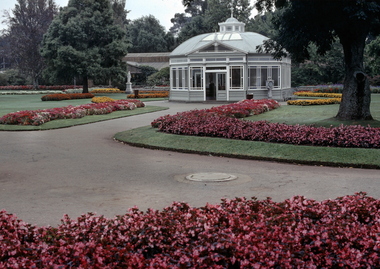
35 mm Slide, Statuary Pavilion, Ballarat Botanical Gardens circa late1950s
James Russell Thompson (1818-1886) a successful mining investor and stockbroker of the Ballarat Stock Exchange, gifted the pavilion and the statues within, as a 10,000 pound bequest to the City in his will. The pavilion, designed by architect T.E. Molloy on an octagonal plan with a convex curved roof, was constructed in 1887, and houses the statues Flight from Pompeii, Rebekah, Susannah, Modesty and Ruth. The pavilion is a major feature of the Ballarat Botanical Gardens, and unique in Victoria. It is a favourite subject for photographers, and Mrs Strange has captured it surrounded by massed small begonias. Mrs Bon Strange and her husband Bert were well known Ballarat residents. When Mrs Strange died some years ago, her extensive slide collection was sorted through and those relevant to Ballarat were gifted to the Ballarat Library. botanical gardens, lake wendouree, james russell thompson, statuary pavilion, weighing machine -
 Otway Districts Historical Society
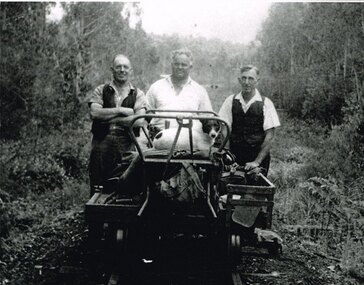
Photograph, Albert Denning, Colac track gang near Kawarren, c.1950
In 1955 staff numbers were reduced to an absolute minimum with one track gang at Beech Forest and one at Colac, one of whose members resided at Gellibrand. No new sleepers were issued to the track gangs after 1955/56, cut down ones being used instead. Albert Denning, the son of a Gellibrand selector, worked at Driver's planing mill and Hitt's Lardner mill before joining Victorian Railways in 1928 as an engine cleaner at Beech Forest and Crowes, the last one in both places. He later became a track repairer at Gellibrand and worked with this and the Colac track gang until 1962. Bill Jamieson was a track repairer on the Colac-Gellibrand gang from the 1950s until 1962, and witnessed the official policy of minimum maintenance in the last years of the line.B/W. 201mm x 254mm. In c.1950, the Colac track gang near Kawarren, featuring, from left to right, Bill Jamieson, Albert Denning, and Don Loury on an NKS motor trolley..colac; kawarren; railways; track gangs; -
 Bendigo Historical Society Inc.
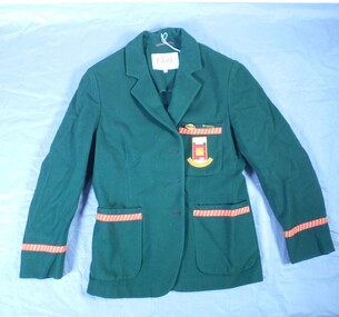
Textile - High School Blazer
Golden Square High School in the city of Bendigo, was established in temporary accommodation at Camp Hill Primary School in central Bendigo in 1960. With the completion of the new school's buildings, it moved to Golden Square in 1962, providing for Forms 1 to 6, now known as years 7 to 12. In 1978 it became a 7–10 school and was one of the original feeder schools to Bendigo Senior High School. In 1986, a Hearing Impaired Unit was established and in 1990 it underwent a name change to become Golden Square Secondary College. The Golden Square Secondary College campus closed on 28 November 2008. It merged with Kangaroo Flat and Flora Hill secondary colleges as part of the implementation of the Bendigo Education Plan. Its buildings were demolished. (Wikipedia https://en.wikipedia.org/wiki/Golden_Square_Secondary_College)Golden Square High School Blazer. The green blazer has one upper and two lower pockets, each lined at the top with a strip of gold fabric with diagonal red stripes and a row of red stitching bordering the strip. The top pocket shows the school emblem i colours of green, gold, red and white in square and rectangular block formation. "High School" is written in gold against a white background at the top of the emblem and "Golden Square" is embroidered in part circle below the emblem. The name is dark gold against a fainter gold background. The Blazer is fastened with three buttons. Only one button remains attached. Another button is in a pocket. A label under the collar reads "Tailored by Clark in Pure wool' "Size 34". Two badges are pinned to the top pocket. "PREFECT" . Reflecting the school colours - gold lettering on red on a green rectangle set against a gold oval shape. "S.R.C." Gold lettering on green background.Written on the label "K Jeffrey 7G". Also written in pen on the lining inside of the upper arm. There is also another crossed out name.gssc, school uniform -
 Bendigo Historical Society Inc.
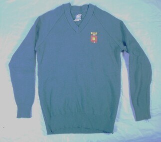
Textile - High School jumper
Golden Square High School in the city of Bendigo, was established in temporary accommodation at Camp Hill Primary School in central Bendigo in 1960. With the completion of the new school's buildings, it moved to Golden Square in 1962, providing for Forms 1 to 6, now known as years 7 to 12. In 1978 it became a 7–10 school and was one of the original feeder schools to Bendigo Senior High School. In 1986, a Hearing Impaired Unit was established and in 1990 it underwent a name change to become Golden Square Secondary College. The Golden Square Secondary College campus closed on 28 November 2008. It merged with Kangaroo Flat and Flora Hill secondary colleges as part of the implementation of the Bendigo Education Plan. Its buildings were demolished. (Wikipedia https://en.wikipedia.org/wiki/Golden_Square_Secondary_College)Navy jumper. School emblem embroidered with "GOLDEN SQUARE" in navy and black placed above squares / shapes in a maze like pattern. A label on the back "DUX" "Made by Dobson's" Size 16. Reverse of label details washing instructions and identifies composition 80% wool and 20% nylon. gssc, school uniform -
 Bendigo Historical Society Inc.
Textile - High School windcheater
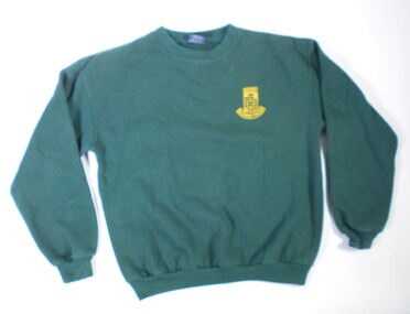
Golden Square High School in the city of Bendigo, was established in temporary accommodation at Camp Hill Primary School in central Bendigo in 1960. With the completion of the new school's buildings, it moved to Golden Square in 1962, providing for Forms 1 to 6, now known as years 7 to 12. In 1978 it became a 7–10 school and was one of the original feeder schools to Bendigo Senior High School. In 1986, a Hearing Impaired Unit was established and in 1990 it underwent a name change to become Golden Square Secondary College. The Golden Square Secondary College campus closed on 28 November 2008. It merged with Kangaroo Flat and Flora Hill secondary colleges as part of the implementation of the Bendigo Education Plan. Its buildings were demolished. (Wikipedia https://en.wikipedia.org/wiki/Golden_Square_Secondary_College)Dark green windcheater with school emblem. Embroidered in gold. "Golden Square Secondary College". Brand label on the back "OZ Surf. Made in China.. Size Small." Washing instructions included.gssc, school uniform, gshs -
 Bendigo Historical Society Inc.
Textile - GSSC Sports top
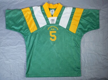
Golden Square High School in the city of Bendigo, was established in temporary accommodation at Camp Hill Primary School in central Bendigo in 1960. With the completion of the new school's buildings, it moved to Golden Square in 1962, providing for Forms 1 to 6, now known as years 7 to 12. In 1978 it became a 7–10 school and was one of the original feeder schools to Bendigo Senior High School. In 1986, a Hearing Impaired Unit was established and in 1990 it underwent a name change to become Golden Square Secondary College. The Golden Square Secondary College campus closed on 28 November 2008. It merged with Kangaroo Flat and Flora Hill secondary colleges as part of the implementation of the Bendigo Education Plan. Its buildings were demolished. (Wikipedia https://en.wikipedia.org/wiki/Golden_Square_Secondary_College)Dark green short sleeved synthetic sports top with gold coloured V shaped collar. There are gold and white diagonal stripes on the collar. Symbol on the front of a soccer ball and decorative wreath with letters "SSI" and "Golden Square S C" The number % is in large print on the front and back. Made in Thailand.gssc, sports top -
 Bendigo Historical Society Inc.
Textile - School Banner
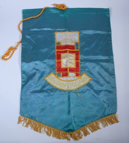
Golden Square High School in the city of Bendigo, was established in temporary accommodation at Camp Hill Primary School in central Bendigo in 1960. With the completion of the new school's buildings, it moved to Golden Square in 1962, providing for Forms 1 to 6, now known as years 7 to 12. In 1978 it became a 7–10 school and was one of the original feeder schools to Bendigo Senior High School. In 1986, a Hearing Impaired Unit was established and in 1990 it underwent a name change to become Golden Square Secondary College. The Golden Square Secondary College campus closed on 28 November 2008. It merged with Kangaroo Flat and Flora Hill secondary colleges as part of the implementation of the Bendigo Education Plan. Its buildings were demolished. (Wikipedia https://en.wikipedia.org/wiki/Golden_Square_Secondary_College)Golden Square High School banner. A large green banner made of silk like material. The lower edge of the banner is fringed with gold coloured cord. A thick gold coloured hanging cord is attached to the top.gssc, sports top -
 Bendigo Historical Society Inc.
Award - School Sport Shields
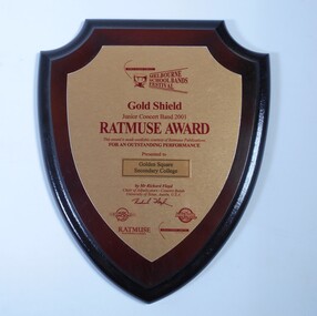
Golden Square High School in the city of Bendigo, was established in temporary accommodation at Camp Hill Primary School in central Bendigo in 1960. With the completion of the new school's buildings, it moved to Golden Square in 1962, providing for Forms 1 to 6, now known as years 7 to 12. In 1978 it became a 7–10 school and was one of the original feeder schools to Bendigo Senior High School. In 1986, a Hearing Impaired Unit was established and in 1990 it underwent a name change to become Golden Square Secondary College. The Golden Square Secondary College campus closed on 28 November 2008. It merged with Kangaroo Flat and Flora Hill secondary colleges as part of the implementation of the Bendigo Education Plan. Its buildings were demolished. (Wikipedia https://en.wikipedia.org/wiki/Golden_Square_Secondary_College)Two wooden shields awarded to Golden Square Secondary College at the Melbourne School Bands Festival. Dark wood in the shape of a shield. a. Gold Shield awarded to the Junior Concert Band in 2001. TATMUSE AWARD for Outstanding Performance. Presented by Mr Richard Floyd. Sponsors represented by logos - Music Junction, Billy Hyde, RATMUSE (Music Publishers). Education Trust Vic. b. Yamaha Gold Award won by Golden Square Secondary College Intermediate Concert band 2003 at the Melbourne School Bands Festival. Presented to Symphonic Winds by Mr. K Waterworth. Award sponsored by Yamaha Music Australia, Billy Hyde Music. Blue border around a gold coloured shield.a. Sticker on the back of the Shield. "WINNING EDGE PRESENTATIONS Wholesale Trophy Framing and Giftware level 9 230 Collins Street Melbourne phone 9654 4911 Fax 9650 7106"gssc, sports top, music awards -
![Kew [Willsmere] Mental Hospital](/media/collectors/550653872162f11fb04854aa/items/5c24a85e21ea6710e4eb189a/item-media/5c24a97321ea6710e4ec94fe/item-fit-380x285.jpg) Kew Historical Society Inc
Kew Historical Society IncAlbum, Kew [Willsmere] Mental Hospital, 1872-1965
The new Kew Lunatic Asylum was completed in 1871 and opened in 1872. The year 1972 marked it's centenary. Over the years, members of staff at the asylum collected records, photographs, publications and plans of the asylum, later hospital. The Society has a number of important collections relating to the asylum and the Children's Cottages. These include the Dr Cliff Judge, the Irena Higgins and the Dr Fred Stamp Collections. This item was one of a number donated by the family of the late Dr. Fred Stamp who was the last medical superintendent of the Hospital. Dr Frederick Stamp graduated from Bristol Medical School (UK) in 1968. He and his family emigrated to Australia in 1977 to Goulburn (NSW), moving to Melbourne in 1980. He became Superintendent at Willsmere in 1981 until its closure in 1988.Following their closure, the medical records of the Kew Mental Hospital and the Children's Cottages Kew were relocated to the archives of Victorian Government departments and ultimately to the Public Records Office of Victoria. Other collections, such as the Fred Stamp Collection, were assembled by staff who worked at the hospital. The years leading up to the closure of Kew must have been fraught, and many of the items in the hospital were probably destined for hard waste disposal. Dr. Fred Stamp, the last medical superintendent, kept aside or rescued a number of these items, of which this is one. Following his death, his family donated these to the Kew Historical Society. The Society recognises these items to be of lasting historical significance, essentially due to their provenance and to their rarity. Together they (and the Judge and Higgins Collections) are an invaluable aid for researchers of the institutions' histories.Red vinyl photographic album containing 43 images of the Kew Mental Hospital from its origins until ca. 1965. Within the album, there are a range of photos of various sizes. Photos are typically labelled by date, especially within decade. The photos are of varying quality and historical significance. the subject of the photos in the album include architectural features, internal and external environments, patients and staff. Those to be published separately are deemed to be unique and or significant. The album forms part of the Dr. Fred Stamp Collection.kew lunatic asylum, kew mental hospital, willsmere, kew hospital for the insane, dr fred stamp, the fred stamp collection -
![Photographs, Envelope of Photographs: Kew [Willsmere] Mental Hospital, 1960-1972](/media/collectors/550653872162f11fb04854aa/items/5c24af7521ea6710e4f35c32/item-media/5c24b38621ea6710e4f7dd74/item-fit-380x285.jpg) Kew Historical Society Inc
Kew Historical Society IncPhotographs, Envelope of Photographs: Kew [Willsmere] Mental Hospital, 1960-1972
The new Kew Lunatic Asylum was completed in 1871 and opened in 1872. The year 1972 marked it's centenary. Over the years, members of staff at the asylum collected records, photographs, publications and plans of the asylum, later hospital. The Society has a number of important collections relating to the asylum and the Children's Cottages. These include the Dr Cliff Judge, the Irena Higgins and the Dr Fred Stamp Collections. These photographs were one of a number of items donated by the family of the late Dr. Fred Stamp who was the last medical superintendent of the Hospital. Dr Frederick Stamp graduated from Bristol Medical School (UK) in 1968. He and his family emigrated to Australia in 1977 to Goulburn (NSW), moving to Melbourne in 1980. He became Superintendent at Willsmere in 1981 until its closure in 1988.Following their closure, the medical records of the Kew Mental Hospital and the Children's Cottages Kew were relocated to the archives of Victorian Government departments and ultimately to the Public Records Office of Victoria. Other collections, such as the Fred Stamp Collection, were assembled by staff who worked at the hospital. The years leading up to the closure of Kew must have been fraught, and many of the items in the hospital were probably destined for hard waste disposal. Dr. Fred Stamp, the last medical superintendent, kept aside or rescued a number of these items, of which this is one group. Following his death, his family donated these to the Kew Historical Society. The Society recognises these items to be of lasting historical significance, essentially due to their provenance and to their rarity. Together they (and the Judge and Higgins Collections) are an invaluable aid for researchers of the institutions' histories.83 black & white and colour photographs of the Kew Mental Hospital, its patients, its environs, and the 1972 Centenary celebrations. A number of photographs in the envelope are duplicate copies. Some have information inscribed on the reverse. Those to be published separately are deemed to be unique and or significant. The photos form part of the Dr. Fred Stamp Collection.kew lunatic asylum, kew mental hospital, willsmere, kew hospital for the insane, dr fred stamp, the fred stamp collection -
![Document, Numerical Register [Surgical Unit, Kew Mental Hospital], 1969-1983, 1969-1983](/media/collectors/550653872162f11fb04854aa/items/5c24b3e421ea6710e4f85ebe/item-media/5c24b64221ea6710e4fc0c08/item-fit-380x285.jpg) Kew Historical Society Inc
Kew Historical Society IncDocument, Numerical Register [Surgical Unit, Kew Mental Hospital], 1969-1983, 1969-1983
The new Kew Lunatic Asylum was completed in 1871 and opened in 1872. The year 1972 marked it's centenary. Over the years, members of staff at the asylum collected records, photographs, publications and plans of the asylum, later hospital. The Society has a number of important collections relating to the asylum and the Children's Cottages. These include the Dr Cliff Judge, the Irena Higgins and the Dr Fred Stamp Collections. This Numerical Register was one of a number of items donated by the family of the late Dr. Fred Stamp who was the last medical superintendent of the Hospital. Dr Frederick Stamp graduated from Bristol Medical School (UK) in 1968. He and his family emigrated to Australia in 1977 to Goulburn (NSW), moving to Melbourne in 1980. He became Superintendent at Willsmere in 1981 until its closure in 1988.Following their closure, the medical records of the Kew Mental Hospital and the Children's Cottages Kew were relocated to the archives of Victorian Government departments and ultimately to the Public Records Office of Victoria. Other collections, such as the Fred Stamp Collection, were assembled by staff who worked at the hospital. The years leading up to the closure of Kew must have been fraught, and many of the items in the hospital were probably destined for hard waste disposal. Dr. Fred Stamp, the last medical superintendent, kept aside or rescued a number of these items, of which this is one. Following his death, his family donated these to the Kew Historical Society. The Society recognises these items to be of lasting historical significance, essentially due to their provenance and to their rarity. Together they (and the Judge and Higgins Collections) are an invaluable aid for researchers of the institutions' histories.Leather bound register listing the numbers of male and female resident staff, male and female patients in the Surgical Unit between December 1969 and June 1983. The manuscript forms part of the Dr. Fred Stamp Collection.Embossed on spine "Numerical Register / Kew"kew lunatic asylum, kew mental hospital, willsmere, kew hospital for the insane, dr fred stamp, the fred stamp collection -
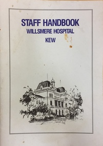 Kew Historical Society Inc
Booklet, Staff Handbook, Willsmere Hospital, Kew, c.1979
The new Kew Lunatic Asylum was completed in 1871 and opened in 1872. The year 1972 marked it's centenary. Over the years, members of staff at the asylum collected records, photographs, publications and plans of the asylum, later hospital. The Society has a number of important collections relating to the asylum and the Children's Cottages. These include the Dr Cliff Judge, the Irena Higgins and the Dr Fred Stamp Collections. This Numerical Register was one of a number of items donated by the family of the late Dr. Fred Stamp who was the last medical superintendent of the Hospital. Dr Frederick Stamp graduated from Bristol Medical School (UK) in 1968. He and his family emigrated to Australia in 1977 to Goulburn (NSW), moving to Melbourne in 1980. He became Superintendent at Willsmere in 1981 until its closure in 1988.Following their closure, the medical records of the Kew Mental Hospital and the Children's Cottages Kew were relocated to the archives of Victorian Government departments and ultimately to the Public Records Office of Victoria. Other collections, such as the Fred Stamp Collection, were assembled by staff who worked at the hospital. The years leading up to the closure of Kew must have been fraught, and many of the items in the hospital were probably destined for hard waste disposal. Dr. Fred Stamp, the last medical superintendent, kept aside or rescued a number of these items, of which this is one. Following his death, his family donated these to the Kew Historical Society. The Society recognises these items to be of lasting historical significance, essentially due to their provenance and to their rarity. Together they (and the Judge and Higgins Collections) are an invaluable aid for researchers of the institutions' histories.Printed Staff Handbook for use at the Kew [Willsmere] Mental Hospital. The image on the cover is dated [19]79, so the handbook post-dates that year.STAFF HANDBOOK / WILLSMERE HOSPITAL / KEWkew lunatic asylum, kew mental hospital, willsmere, kew hospital for the insane, dr fred stamp, the fred stamp collection -
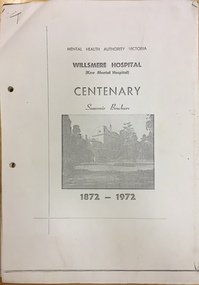 Kew Historical Society Inc
Document - Souvenir brochure [photocopy], Mental Health Authority (Victoria), Willsmere Hospital (Kew Mental Hospital), Centenary Souvenir Brochure, 1872-1972, 1972
The new Kew Lunatic Asylum was completed in 1871 and opened in 1872. The year 1972 marked it's centenary. Over the years, members of staff at the asylum collected records, photographs, publications and plans of the asylum, later hospital. The Society has a number of important collections relating to the asylum and the Children's Cottages. These include the Dr Cliff Judge, the Irena Higgins and the Dr Fred Stamp Collections. This photocopied brochure is one of a number of items donated by the family of the late Dr. Fred Stamp who was the last medical superintendent of the Hospital. Dr Frederick Stamp graduated from Bristol Medical School (UK) in 1968. He and his family emigrated to Australia in 1977 to Goulburn (NSW), moving to Melbourne in 1980. He became Superintendent at Willsmere in 1981 until its closure in 1988.Following their closure, the medical records of the Kew Mental Hospital and the Children's Cottages Kew were relocated to the archives of Victorian Government departments and ultimately to the Public Records Office of Victoria. Other collections, such as the Fred Stamp Collection, were assembled by staff who worked at the hospital. The years leading up to the closure of Kew must have been fraught, and many of the items in the hospital were probably destined for hard waste disposal. Dr. Fred Stamp, the last medical superintendent, kept aside or rescued a number of these items, of which this is one. Following his death, his family donated these to the Kew Historical Society. The Society recognises these items to be of lasting historical significance, essentially due to their provenance and to their rarity. Together they (and the Judge and Higgins Collections) are an invaluable aid for researchers of the institutions' histories.A photocopy of the Willsmere Hospital (Kew Mental Hospital) Centenary Souvenir Brochure, 1872-1972. The Society also has an original copy in its collection.kew lunatic asylum, kew mental hospital, willsmere, kew hospital for the insane, dr fred stamp, the fred stamp collection -
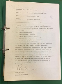 Kew Historical Society Inc
Newspaper (series) - Willsmere Unit, Staff Newsletters, 1986-1988
Dr Fred Stamp (1981-8) > Rosemary Barnes (2018) > Kew Historical Society (2018)CommunicationProvenance OrderStaff newsletters published between 1986 and 1988. Issued by the Medical Superintendent of the Willsmere Unit. The newsletters were published during the final years of the Willsmere Unit (formerly Kew Asylum) kew lunatic asylum, kew mental hospital, willsmere, kew hospital for the insane, dr fred stamp, the fred stamp collectionkew lunatic asylum, kew mental hospital, willsmere, kew hospital for the insane, dr fred stamp, the fred stamp collection -
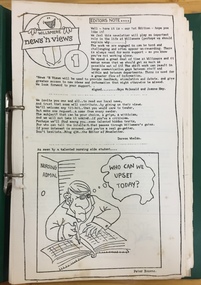 Kew Historical Society Inc
Newspaper (series) - Willsmere Unit, Willsmere News 'n Views, 1986-1988
Dr Fred Stamp (1981-88) > Rosemary Barnes (2018) > Kew Historical Society (2018)CommunicationProvenance OrderNewsletters to parents and friends of the Willsmere Unit, created in 1986-1988; the final years of the Unit (formerly Kew Asylum)kew lunatic asylum, kew mental hospital, willsmere, kew hospital for the insane, dr fred stamp, the fred stamp collectionkew lunatic asylum, kew mental hospital, willsmere, kew hospital for the insane, dr fred stamp, the fred stamp collection -
 Kew Historical Society Inc
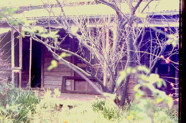
Slide - 'Reno', St John 's Parade, 1977
‘Reno’, stood on the east side of St John’s Parade. Its earliest recorded owner was the architect Samuel Cocking who lived there from c.1865 until his death in 1888. The original landholding was bordered by Cotham Road, Glenferrie Road, Wellington Street, and Charles Street. The southern portion of this land included a fine orchard, with many imported trees. The old summer house, at first in the orchard, was later removed to the house garden. The MMBW Detail Plan No.1576 (1904) shows the remaining portion of the original land holding, including a semi-circular pathway at the front, and garden features such as an aviary, a fountain and grotto, and a fernery. The garden including rare plants supplied by Baron Von Mueller, surrounds the cottage in a tangled frenzy. Despite a ‘local significance’ classification by the National Trust, the house was demolished in 1977.Rare photograph of an historically important weatherboard cottage in St John's Parade.Colour positive transparency (slide) of the verandah of 'Reno' in St John's Parade, Kew (demolished 1977). historic houses -- kew (vic.), reno -- st john's parade -- kew (vic.) -
 Kew Historical Society Inc
Slide - 'Reno', St John 's Parade, 1977
‘Reno’, stood on the east side of St John’s Parade. Its earliest recorded owner was the architect Samuel Cocking who lived there from c.1865 until his death in 1888. The original landholding was bordered by Cotham Road, Glenferrie Road, Wellington Street, and Charles Street. The southern portion of this land included a fine orchard, with many imported trees. The old summer house, at first in the orchard, was later removed to the house garden. The MMBW Detail Plan No.1576 (1904) shows the remaining portion of the original land holding, including a semi-circular pathway at the front, and garden features such as an aviary, a fountain and grotto, and a fernery. The garden including rare plants supplied by Baron Von Mueller, surrounds the cottage in a tangled frenzy. Despite a ‘local significance’ classification by the National Trust, the house was demolished in 1977.Rare photograph of an historically important weatherboard cottage in St John's Parade.Colour positive transparency (slide) of the a doorway of 'Reno' in St John's Parade, Kew (demolished 1977). historic houses -- kew (vic.), reno -- st john's parade -- kew (vic.) -
 Kew Historical Society Inc
Slide - 'Reno', St John 's Parade, 1977
‘Reno’, stood on the east side of St John’s Parade. Its earliest recorded owner was the architect Samuel Cocking who lived there from c.1865 until his death in 1888. The original landholding was bordered by Cotham Road, Glenferrie Road, Wellington Street, and Charles Street. The southern portion of this land included a fine orchard, with many imported trees. The old summer house, at first in the orchard, was later removed to the house garden. The MMBW Detail Plan No.1576 (1904) shows the remaining portion of the original land holding, including a semi-circular pathway at the front, and garden features such as an aviary, a fountain and grotto, and a fernery. The garden including rare plants supplied by Baron Von Mueller, surrounds the cottage in a tangled frenzy. Despite a ‘local significance’ classification by the National Trust, the house was demolished in 1977.Rare photograph of an historically important weatherboard cottage in St John's Parade.Colour positive transparency (slide) of the verandah of 'Reno' in St John's Parade, Kew (demolished 1977). historic houses -- kew (vic.), reno -- st john's parade -- kew (vic.) -
 Kew Historical Society Inc
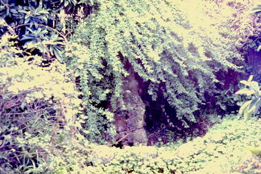
Slide - Grotto of 'Reno', St John 's Parade, 1977
‘Reno’, stood on the east side of St John’s Parade. Its earliest recorded owner was the architect Samuel Cocking who lived there from c.1865 until his death in 1888. The original landholding was bordered by Cotham Road, Glenferrie Road, Wellington Street, and Charles Street. The southern portion of this land included a fine orchard, with many imported trees. The old summer house, at first in the orchard, was later removed to the house garden. The MMBW Detail Plan No.1576 (1904) shows the remaining portion of the original land holding, including a semi-circular pathway at the front, and garden features such as an aviary, a fountain and grotto, and a fernery. The garden including rare plants supplied by Baron Von Mueller, surrounds the cottage in a tangled frenzy. Despite a ‘local significance’ classification by the National Trust, the house was demolished in 1977.Rare photograph of an historically important weatherboard cottage in St John's Parade.Colour positive transparency (slide) of the grotto in the garden of 'Reno' in St John's Parade, Kew (demolished 1977). historic houses -- kew (vic.), reno -- st john's parade -- kew (vic.) -
 Kew Historical Society Inc
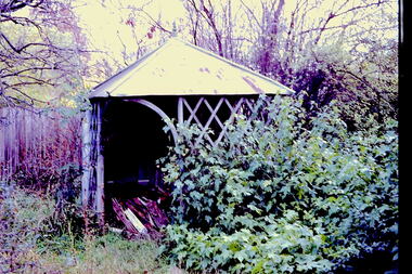
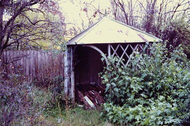
Slide - Former Summerhouse in the Garden of 'Reno', St John 's Parade, 1977
‘Reno’, stood on the east side of St John’s Parade. Its earliest recorded owner was the architect Samuel Cocking who lived there from c.1865 until his death in 1888. The original landholding was bordered by Cotham Road, Glenferrie Road, Wellington Street, and Charles Street. The southern portion of this land included a fine orchard, with many imported trees. The old summer house, at first in the orchard, was later removed to the house garden. The MMBW Detail Plan No.1576 (1904) shows the remaining portion of the original land holding, including a semi-circular pathway at the front, and garden features such as an aviary, a fountain and grotto, and a fernery. The garden including rare plants supplied by Baron Von Mueller, surrounds the cottage in a tangled frenzy. Despite a ‘local significance’ classification by the National Trust, the house was demolished in 1977.Rare photograph of an historically important weatherboard cottage in St John's Parade.Colour positive transparency (slide) of the former summerhouse in the garden of 'Reno' in St John's Parade, Kew (demolished 1977). historic houses -- kew (vic.), reno -- st john's parade -- kew (vic.) -
 Kew Historical Society Inc
Slide - 'Reno', St John 's Parade, 1977
‘Reno’, stood on the east side of St John’s Parade. Its earliest recorded owner was the architect Samuel Cocking who lived there from c.1865 until his death in 1888. The original landholding was bordered by Cotham Road, Glenferrie Road, Wellington Street, and Charles Street. The southern portion of this land included a fine orchard, with many imported trees. The old summer house, at first in the orchard, was later removed to the house garden. The MMBW Detail Plan No.1576 (1904) shows the remaining portion of the original land holding, including a semi-circular pathway at the front, and garden features such as an aviary, a fountain and grotto, and a fernery. The garden including rare plants supplied by Baron Von Mueller, surrounds the cottage in a tangled frenzy. Despite a ‘local significance’ classification by the National Trust, the house was demolished in 1977.Rare photograph of an historically important weatherboard cottage in St John's Parade.Colour positive transparency (slide) of the garden of 'Reno' in St John's Parade, Kew (demolished 1977). historic houses -- kew (vic.), reno -- st john's parade -- kew (vic.) -
 Kew Historical Society Inc
Slide - Former Summerhouse in the Garden of 'Reno', St John 's Parade, 1977
‘Reno’, stood on the east side of St John’s Parade. Its earliest recorded owner was the architect Samuel Cocking who lived there from c.1865 until his death in 1888. The original landholding was bordered by Cotham Road, Glenferrie Road, Wellington Street, and Charles Street. The southern portion of this land included a fine orchard, with many imported trees. The old summer house, at first in the orchard, was later removed to the house garden. The MMBW Detail Plan No.1576 (1904) shows the remaining portion of the original land holding, including a semi-circular pathway at the front, and garden features such as an aviary, a fountain and grotto, and a fernery. The garden including rare plants supplied by Baron Von Mueller, surrounds the cottage in a tangled frenzy. Despite a ‘local significance’ classification by the National Trust, the house was demolished in 1977.Rare photograph of an historically important weatherboard cottage in St John's Parade.Colour positive transparency (slide) of the former summerhouse in the garden of 'Reno' in St John's Parade, Kew (demolished 1977). historic houses -- kew (vic.), reno -- st john's parade -- kew (vic.) -
 Kew Historical Society Inc
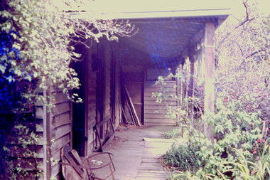
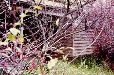
Photograph - 'Reno', 10 St John's Parade, John T Collins, 1977
‘Reno’, stood on the east side of St John’s Parade. Its earliest recorded owner was the architect Samuel Cocking who lived there from c.1865 until his death in 1888. The original landholding was bordered by Cotham Road, Glenferrie Road, Wellington Street, and Charles Street. The southern portion of this land included a fine orchard, with many imported trees. The old summer house, at first in the orchard, was later removed to the house garden. The MMBW Detail Plan No.1576 (1904) shows the remaining portion of the original land holding, including a semi-circular pathway at the front, and garden features such as an aviary, a fountain and grotto, and a fernery. The garden including rare plants supplied by Baron Von Mueller, surrounds the cottage in a tangled frenzy. Despite a ‘local significance’ classification by the National Trust, the house was demolished in 1977.Partial view, north side of the weatherboard cottage in St John's Parade, Kew, known as 'Reno' (demolished 1977). Architectural elements revealed in this photo by John T Collins include: two wing, hip roof construction; external buildings at angles to main wing; corrugated iron roofing [over shingles]; brick chimney external to building; unvarnished/unpainted external weatherboards. General dilapidated condition. "Kew 'Reno' 10 St Johns Pde / John Collins, 11 Anderson Road, Hawthorn East, 3123, Film 35B Exposure 27"reno - st john's parade -- kew (vic.), john t collins -
 Kew Historical Society Inc
Photograph - 'Reno', 10 St John's Parade, John T Collins, 1977
‘Reno’, stood on the east side of St John’s Parade. Its earliest recorded owner was the architect Samuel Cocking who lived there from c.1865 until his death in 1888. The original landholding was bordered by Cotham Road, Glenferrie Road, Wellington Street, and Charles Street. The southern portion of this land included a fine orchard, with many imported trees. The old summer house, at first in the orchard, was later removed to the house garden. The MMBW Detail Plan No.1576 (1904) shows the remaining portion of the original land holding, including a semi-circular pathway at the front, and garden features such as an aviary, a fountain and grotto, and a fernery. The garden including rare plants supplied by Baron Von Mueller, surrounds the cottage in a tangled frenzy. Despite a ‘local significance’ classification by the National Trust, the house was demolished in 1977.Partial view, side of the weatherboard cottage in St John's Parade, Kew, known as 'Reno' (demolished 1977). Architectural elements revealed in this photo by John T Collins include: hip roof construction; corrugated iron roofing [over shingles]; unvarnished/unpainted external weatherboards; Externally opening 1860s-style casement window. General dilapidated condition. "Kew 'Reno' 10 St Johns Pde / John Collins, 11 Anderson Road, Hawthorn East, 3123, Film 35B Exposure 26"reno - st john's parade -- kew (vic.), john t collins -
 Kew Historical Society Inc
Photograph - 'Reno', 10 St John's Parade, John T Collins, 1977
‘Reno’, stood on the east side of St John’s Parade. Its earliest recorded owner was the architect Samuel Cocking who lived there from c.1865 until his death in 1888. The original landholding was bordered by Cotham Road, Glenferrie Road, Wellington Street, and Charles Street. The southern portion of this land included a fine orchard, with many imported trees. The old summer house, at first in the orchard, was later removed to the house garden. The MMBW Detail Plan No.1576 (1904) shows the remaining portion of the original land holding, including a semi-circular pathway at the front, and garden features such as an aviary, a fountain and grotto, and a fernery. The garden including rare plants supplied by Baron Von Mueller, surrounds the cottage in a tangled frenzy. Despite a ‘local significance’ classification by the National Trust, the house was demolished in 1977.Side of the original, relocated summer house of 'Reno' at 10 St John's Parade, Kew, (demolished 1977). Architectural elements revealed in this photo by John T Collins include: four-sided construction; trellis and weatherboard walls; corrugated iron roofing. Re-use as woodshed. General dilapidated condition. "Kew 'Reno' 10 St Johns Pde / John Collins, 11 Anderson Road, Hawthorn East, 3123, Film 35B Exposure 24"reno - st john's parade -- kew (vic.), john t collins -
 Kew Historical Society Inc
Photograph - Yarra Valley Floods: Kew East, 1916
Flooding of the Yarra Valley, including that section of the Yarra bordering Kew and Kew East in the north and west of the municipality, was a regular occurrence. Extreme flood events of the Yarra River are recorded to have occurred in 1891, 1901, 1916, 1923 and 1934. The Municipality of Kew's response to these floods was to enact planning decisions restricting residential development in flood prone areas following the floods of 1916, 1921 and 1934. While floods continued after the development of the Upper Yarra Reservoir (construction 1948-57), the regularity and extent of these inundations diminished. During the nineteenth century, the land abutting the south side of the Yarra in Kew was devoted to dairy farming. In the twentieth century, before and after the construction of the Eastern Freeway, much of this low-lying area was used as golf courses and public parks.One of a collection of photographs of flooding in the Kew section of the Yarra Valley which are in important research resource for the location and extent of flooding in the first half of the twentieth century. Flooding of the Yarra Valley at East Kew in 1916. The view is taken from the intersection of Kilby Road with what is believed to be Birdwood Street, looking across the flood waters to Ivanhoe. The extensive flooded area shown in the photograph would have included the Kew Golf Club. Verso: "Floods along Kilby Road / near Birdwood St? & Kilby Road / 1917? / 87yarra river, yarra valley, floods -- kew, kilby road -- kew (vic.), kew golf club -
 Kew Historical Society Inc
Photograph - Yarra Valley Floods: Kew East, 1916
Flooding of the Yarra Valley, including that section of the Yarra bordering Kew and Kew East in the north and west of the municipality, was a regular occurrence. Extreme flood events of the Yarra River are recorded to have occurred in 1891, 1901, 1916, 1923 and 1934. The Municipality of Kew's response to these floods was to enact planning decisions restricting residential development in flood prone areas following the floods of 1916, 1921 and 1934. While floods continued after the development of the Upper Yarra Reservoir (construction 1948-57), the regularity and extent of these inundations diminished. During the nineteenth century, the land abutting the south side of the Yarra in Kew was devoted to dairy farming. In the twentieth century, before and after the construction of the Eastern Freeway, much of this low-lying area was used as golf courses and public parks.One of a collection of photographs of flooding in the Kew section of the Yarra Valley which are in important research resource for the location and extent of flooding in the first half of the twentieth century. Flooding of the Yarra Valley at East Kew in 1916. The view is taken from a street (maybe Birdwood Avenue) intersecting with Kilby Road looking northeast across the flood waters to Ivanhoe and Heidelberg. The extensive flooded area shown in the photograph would have included remnant dairy farms and the Kew Golf Club. Verso: "Floods / Yarra River / East Kew / Kilby Road / 1917? / 87"yarra river, yarra valley, floods -- kew, kilby road -- kew (vic.), kew golf club -
 Kew Historical Society Inc
Photograph - Flooding of the Yarra Valley at Kew East, 1974
Flooding of the Yarra Valley, including that section of the Yarra bordering Kew and Kew East in the north and west of the municipality, was a regular occurrence. Extreme flood events of the Yarra River are recorded to have occurred in 1891, 1901, 1916, 1923 and 1934. The Municipality of Kew's response to these floods was to enact planning decisions restricting residential development in flood prone areas following the floods of 1916, 1921 and 1934. While floods continued after the development of the Upper Yarra Reservoir (construction 1948-57), the regularity and extent of these inundations diminished. During the nineteenth century, the land abutting the south side of the Yarra in Kew was devoted to dairy farming. In the twentieth century, before and after the construction of the Eastern Freeway, much of this low-lying area was used as golf courses and public parks.Late example of the capacity of the Yarra Valley at Kew to flood, even though drainage works and the Upper Yarra Reservoir had reduced their regularity.Original black and white print photograph of the low-lying land at East Kew under floodwater on 16 May 1974. The vantage point of the photographer is Lister Street. In the photo, the fences of the Kilby Farm can be seen. Flooding was caused by overflowing water in Glass' Creek and the River Yarra. Annotation verso: "Hay's Paddock op No.30 Lister Street / 16 May 1974 11.50am / R.L. 46.04"hays paddock, floods, yarra river, glass' creek, lister street -
 Kew Historical Society Inc
Photograph - Flooding of the Yarra Valley at Kew East, 1974
Flooding of the Yarra Valley, including that section of the Yarra bordering Kew and Kew East in the north and west of the municipality, was a regular occurrence. Extreme flood events of the Yarra River are recorded to have occurred in 1891, 1901, 1916, 1923 and 1934. The Municipality of Kew's response to these floods was to enact planning decisions restricting residential development in flood prone areas following the floods of 1916, 1921 and 1934. While floods continued after the development of the Upper Yarra Reservoir (construction 1948-57), the regularity and extent of these inundations diminished. During the nineteenth century, the land abutting the south side of the Yarra in Kew was devoted to dairy farming. In the twentieth century, before and after the construction of the Eastern Freeway, much of this low-lying area was used as golf courses and public parks.Late example of the capacity of the Yarra Valley at Kew to flood, even though drainage works and the Upper Yarra Reservoir had reduced their regularity.Original black and white print photograph of the low-lying land at East Kew under floodwater on 16 May 1974. The vantage point of the photographer is Lister Street. Flooding was caused by overflowing water in Glass' Creek and the River Yarra. Annotation verso: "Lister Street looking north / Flood level / 16 May 1974 11.30am / R.L. 46.04"hays paddock, floods, yarra river, glass' creek, lister street -
 Kew Historical Society Inc
Photograph - Flooding of the Yarra Valley at Kew East, 1974
Flooding of the Yarra Valley, including that section of the Yarra bordering Kew and Kew East in the north and west of the municipality, was a regular occurrence. Extreme flood events of the Yarra River are recorded to have occurred in 1891, 1901, 1916, 1923 and 1934. The Municipality of Kew's response to these floods was to enact planning decisions restricting residential development in flood prone areas following the floods of 1916, 1921 and 1934. While floods continued after the development of the Upper Yarra Reservoir (construction 1948-57), the regularity and extent of these inundations diminished. During the nineteenth century, the land abutting the south side of the Yarra in Kew was devoted to dairy farming. In the twentieth century, before and after the construction of the Eastern Freeway, much of this low-lying area was used as golf courses and public parks.Late example of the capacity of the Yarra Valley at Kew to flood, even though drainage works and the Upper Yarra Reservoir had reduced their regularity.Original black and white print photograph of Hay's Paddock under floodwater on 16 May 1974. The vantage point of the photographer is Keystone Crescent looking east. Flooding was caused by overflowing water in Glass' Creek and the River Yarra. Annotation verso: "Keystone Cr looking east / 16 May 1974 11.50am"hays paddock, floods, yarra river, glass' creek