Showing 815 items matching " aerial views"
-
 Port Melbourne Historical & Preservation Society
Photograph - Aerial view of Williamstown piers and Alfred Graving Dock, Port of Melbourne Authority, c. 1925
... Aerial view of Williamstown piers and Alfred Graving Dock... with chequered computer border Photograph Aerial view of Williamstown ...Black and white aerial photo of Williamstown Piers and Alfred Graving Dock, with caption, both pasted onto paper with chequered computer bordertransport - shipping, piers and wharves, williamstown, alfred graving dock -
Port Melbourne Historical & Preservation Society
Photograph - Aerial view of the commencement of Appleton Dock, Aug 1925
... Aerial view of the commencement of Appleton Dock... with chequered computer border Photograph Aerial view of the commencement ...Black and white aerial photo of Commencement of Appleton Dock and construction of new river berths, with caption, both pasted onto paper with chequered computer bordertransport - shipping, piers and wharves, yarra river, appleton dock -
Port Melbourne Historical & Preservation Society
Photograph - Aerial view of American destroyers at Victoria Dock, 6 Aug 1925
... Aerial view of American destroyers at Victoria Dock... with chequered computer border Photograph Aerial view of American ...Copy of aerial photo of Victoria Dock 1925 with destroyers from visiting American fleet, with caption, both pasted onto paper with chequered computer bordertransport - shipping, piers and wharves - miscellaneous, victoria dock -
 Port Melbourne Historical & Preservation Society
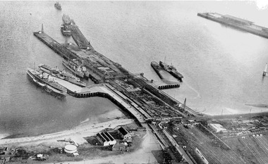
Photograph - Aerial view during construction of Station Pier, Port Melbourne, c. 1925
... Aerial view during construction of Station Pier, Port... Aerial view during construction of Station Pier, Port Melbourne ...Aerial photo showing the double-headed pier created by partially dismantled Railway Pier and partially built Station Pier, late 1920s. Also the new wing piers with paddlesteamers Hygeia, Weeroona and Ozone (latter being broken up), foreshore and railyards, and end of Princes Pier. Pasted on A4 paper printed with computer generated chequered border.transport - shipping, piers and wharves - station pier, piers and wharves - railway pier, ps weeroona, ps hygeia -
Port Melbourne Historical & Preservation Society
Photograph - Aerial view of River Yarra and Victoria Dock, 1920s
... Aerial view of River Yarra and Victoria Dock... border Photograph Aerial view of River Yarra and Victoria Dock ...Copy of aerial photo of River Yarra and Victoria Dock, 1920s; pasted onto A4 sheet with computer graphics bordertransport - shipping -
Port Melbourne Historical & Preservation Society
Postcard - Aerial view of piers at Port Melbourne, Aerial photo of Port Melbourne, c. 1922
... Aerial view of piers at Port Melbourne... Postcard Aerial view of piers at Port Melbourne Valentine & Sons ...Sepia picture postcard, unused, aerial photo showing ships at Port Melbourne: Princes, Station and Town Pierstransport - shipping, piers and wharves - station pier, piers and wharves - princes pier, piers and wharves - town pier -
 Port Melbourne Historical & Preservation Society
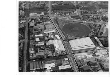
Photograph - Aerial view of J Kitchen & Sons site, Port Melbourne
... Aerial view of J Kitchen & Sons site, Port Melbourne... industrial to the North. Photograph Aerial view of J Kitchen & Sons ...The source of the images is unknown. The date has been estimated in reference to catalogue items 2989 (approx 1945) and 2990 (approx 1970) - both aerial photos of the area.Two black and white aerial photos of J Kitchen & Sons factory prrecinct, approximately 1960s. .01- Looking towards the East with Ingles St in the centre and Port Melbourne cricket/football ground on the right. Rail line is at the top. The Kitchen property is outlined. .02 - Looking towards the North with Port Melbourne cricket/football ground at the bottom, Kitchens (outlined) in the centre and other industrial to the North.built environment - industrial, industry - manufacturing, sport - australian rules football, business and traders - soaps/candles, j kitchen & sons pty ltd, port melbourne football and cricket ground, north port oval -
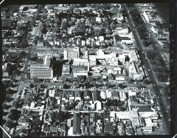
 Bendigo Historical Society Inc.
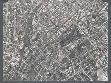
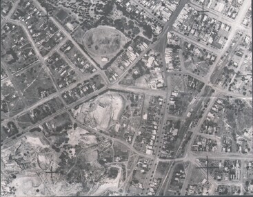
Photograph - WES HARRY COLLECTION: AERIAL VIEW OF BENDIGO CBD, 1966
... WES HARRY COLLECTION: AERIAL VIEW OF BENDIGO CBD...Aerial view of bendigo... PLACE Aerial view of bendigo cbd Bendigo CBD Aerial Survey ...Aerial photograph of the Bendigo CBD. On the reverse is written : 'City of Bendigo 1966, State aerial Surveyplace, aerial view of bendigo, cbd, bendigo cbd, aerial survey of victoria -
 Bendigo Historical Society Inc.
Photograph - HARRY BIGGS COLLECTION: AERIAL PHOTO OF EAGLEHAWK
... aerial view of Eaglehawk... PLACE Streetscape aerial view of Eaglehawk Harry Biggs ...Photograph. Harry Biggs Collection. A black & white overhead photo of Eaglehawk. It clearly shows the football ground, Canterbury Park, Town Hall precinct.place, streetscape, aerial view of eaglehawk, harry biggs collection, aerial photo of eaglehawk -
 Bendigo Historical Society Inc.
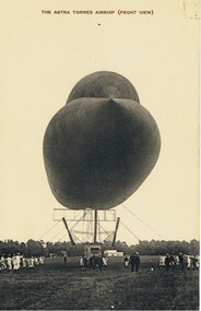
Postcard - BASIL WATSON COLLECTION: POSTCARD: AIRSHIP (ASTRA TORRES), ca. 1914
Black and white postcard - Airship (Astra Torres) titled 'The Astra Torres Airship (Front View)' showing tethered airship on field with personnel, mainly in white uniform, possibly navy personnel. 'Our Aerial Defence Series'John Drew, Aldershot and Farnboroughmilitary, aviation, airship 'astra torres' -
 Bendigo Historical Society Inc.
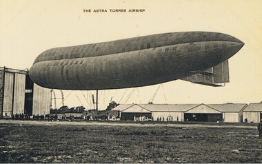
Postcard - BASIL WATSON COLLECTION: POSTCARD - AIRSHIP (ASTRA TORRES), ca. 1914
Black and white postcard . Written on top: 'The Astra Torres Airship' showing side view of tethered airship with personnel below. Airship is outside an airship hanger; aircraft hangers (Montrose base?) in background. 'Our Aerial Defence Series'John Drew, Aldershot & Farnboroughmilitary, aviation, airship 'astra torres' -
 Bendigo Historical Society Inc.
Photograph - BENDIGO - PANORAMA FROM FIRE TOWER
... Aerial view of bendigo... PLACE Aerial view of bendigo fire tower. BENDIGO. PANORAMA FROM ...Photograph - sepia. Photograph panorama from Fire Tower, Bendigo.. In the distance shops that I can read 'Mobiloils', 'Cockings', 'Cocks Motor Garage', back view of the Conservatory building and gardens. The Rose Series P.3231. It is written on back but unable to read much, its from Monica. Trees etc along the bottom front are part the rosalind park.Rose Seriesplace, aerial view of bendigo, fire tower., bendigo. panorama from fire tower. -
 National Vietnam Veterans Museum (NVVM)
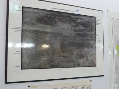
Photograph, Aerial photo of Nui Dat Base
Black & white aerial photo of "Nui Dat - vietnam (1966 - 1972)" oblique view looking north. Arrows point to buildings which are identified in the borders of the photo.nui dat base - buildings -
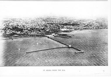 St Kilda Historical Society
Photograph - Photograph Arial
aerial photographPhotograph black and white arial Copy of original. View of water, yachts in foreground and pier with Catani gardenes midground and rest of St kilda in distance.St Kilda from the Sea -
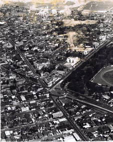 St Kilda Historical Society
Photograph, Aerial view of St Kilda Junction, c. 1970?
... Aerial view of St Kilda Junction... and white photograph poor condition unmounted Aerial view of St ...black and white photograph poor condition unmountedCopyright. This photograph may not be reproduced without permission in writing from the Editor of "The Age". 250 Spencer Street, Melbourne and 39/41 York st, Sydney. -
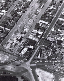 St Kilda Historical Society
Photograph, Aerial view of St Kilda Junction, c. 1967(?)
... Aerial view of St Kilda Junction... and white photographs: one matt, one glossy unmounted Aerial view ...thought to be 24 April 19672 black and white photographs: one matt, one glossy unmountedCopyright. This photograph may not be reproduced without permission in writing from the Editor of "The Age". 250 Spencer Street, Melbourne and 39/41 York st, Sydney. A4582 24.4.1967 -
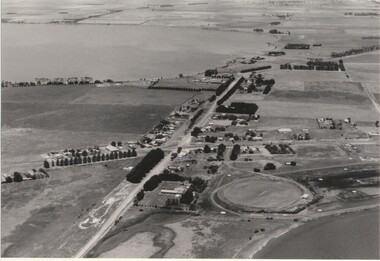
Tatura Irrigation & Wartime Camps Museum
Photograph, Aerial View of Tatura
... Aerial View of Tatura... of Tatura from the air. Aerial View of Tatura Photograph ...Original coloured aerial photographs taken over Tatura. Landmarks include football and cricket ovals, Lake Bartlett, primary school, swimming pool, tennis courts, caravan park, O'Reilly Road, Hastie Road and Maher Road.Coloured photograph of Tatura from the air.on back: Summer January 1987 from Keith Albrect -
Tatura Irrigation & Wartime Camps Museum
Photograph, Aerial camp 13, 1946
... Internment camp 13 Black and white photograph. Aeriel view of Camp 13 ...Aeriel photo of Camp 13Black and white photograph. Aeriel view of Camp 13.camp 13, murchison camp, internment camp 13 -
 Lake Bolac & District Historical Society
Black and white photograph, Aerial view of Lake Bolac township, circa 1970
... Aerial view of Lake Bolac township, circa 1970...., Primary School, High School Aerial view of Lake Bolac township ...Lake Bolac township, 1970. This picture shows the 2nd football oval, tennis courts, golf course and racecourse (front-right) above the salt lake and the Lake Bolac Common (front-left). The Primary School is still on its original site between the oval and the Ararat road. The High School is beside the fresh-water lake (centre back) and to its left are the early caravan park and bowling club. The Aquatic Club shed can just be seen behind the lake bank. Photograph taken by Lewis Wills.lake bolac, football oval, tennis courts, race track, golf course, bowling club, caravan park, aquatic club shed, primary school, high school -
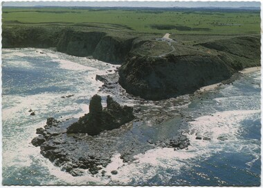 Inverloch Historical Society
004349 Postcard Photograph - Aerial View of Eagles Nest, Inverloch - from Nina Banks - Digital Copy only
... 004349 Postcard Photograph - Aerial View of Eagles Nest...) Inverloch gippsland 004349 Postcard Photograph - Aerial View ... -
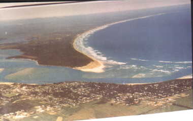 Inverloch Historical Society
000083 - Photograph - Aerial view from Pt (Point) Smythe - Inverloch - R Young
... 000083 - Photograph - Aerial view from Pt (Point) Smythe...) Inverloch gippsland 000083 - Photograph - Aerial view from Pt (Point ... -
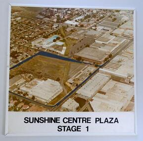 Sunshine and District Historical Society Incorporated
Photograph (1982) - Part Sunshine Business Area, Sunshine Centre Plaza Stage 1, 1982
... Aerial view... of what part of Sunshine looked like 3 decades ago. Aerial view ...The Sunshine business area has undergone major change from industrial manufacturing to retail. This aerial photograph shows the industrial areas that existed on both sides of Hampshire Road in 1982, and which have since been replaced by two shopping centres and the library building. The photograph also shows the old swimming pool, and retail outlets that no longer exist such as Waltons, Clark Rubber, Fosseys and the original Safeway store. It also shows a vacant land where the current Centrelink office now exists. The photograph was originally used as a promotion for the Sunshine Centre Plaza retail complex.This photograph is a historical record of what part of Sunshine looked like 3 decades ago.Large cardboard mounted sepia photograph with thin white plastic edging. Grey painted outline shows the site in 1982 on which the SUNSHINE CENTRE PLAZA was to be built, as well the buildings that then existed in part of the business area of Sunshine.Sunshine Centre Plaza Stage 1aerial view, 1982, sunshine centre plaza, sunshine business area, massey ferguson buildings, old sunshine pool. waltons -
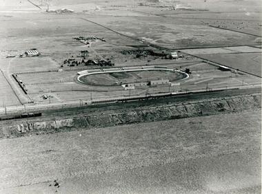 Sunshine and District Historical Society Incorporated
Photographs - WHITE CITY, Pratt, Charles Daniel, (1892 - 1968)
The White City Greyhound racing stadium was built at Tottenham in 1927, with the intention that mechanical lures and not live hares be used as pacemakers. The first meeting was held on 10 December 1927 but within 3 days, after strong lobbying by other sports bodies, the Victorian Government banned betting on greyhound racing if mechanical lures were used instead of live hares. This caused some financial problems to the shareholders. For a time the average weekly attendances were 9000, and races were held on Mondays, Wednesdays, and Saturdays. Whippet Races, Goat Races, Monkeys on greyhounds, and Professional Foot racing were also tried to attract attendances. After 28 years of bureaucratic interference, and using live hares as greyhound pacemakers, the White City stadium held its last meeting on 29 December 1955. On 31 December the Victorian Government finally allowed betting on greyhound races that used mechanical lures. Manufacturing industry (Olex Cables) took over the White City site. Transport to the White City stadium was provided by train, with only a single platform available on the Down side of Tottenham, even though double train lines existed. Special train services were run from Flinders Street to the White City platform, and for a while a parcels coach was provided for the transport of dogs. As industry developed in the area some trains also stopped at the White City platform in the mornings and late afternoons to transport workers. In 1981 when the grade separation at Ashley Street next to the Tottenham station was completed, the new train lines on the Upper Level came into operation, and so the White City platform was closed down and eventually demolished. The above historical information was sourced from the booklet "GOING TO THE DOGS" by Tom Rigg.Greyhound racing has always been popular in Melbourne's western suburbs. The White City stadium in Tottenham was a major centre for the sport until 1955, enabling those who could not afford race horses to take part in an animal racing sport. The demolition of first the stadium and years later the railway platform, has relegated the name White City and its past relevance to the western suburbs, into history.Two low aerial photographs of the White City Coursing stadium (Greyhound racing), plus a CD containing the same two images as well as a few other local images. The Coursing stadium was located about 500 metres from the Tottenham railway station on the down line towards Sunshine station. The photographs are thought to be from circa late 1920's to early 1930's, and one shows the view from the north facing south, while the other from the west facing east. The latter also shows built up areas of West Footscray and beyond.Only on the negatives at the State Library. We do not hold a copy of these.white city, greyhound racing stadium, coursing track, white city station, tottenham, whippet, gambling, live hare, mechanical lure -
 Ballarat Base Hospital Trained Nurses League
Aerial view BBH , neg Mr Harvey Photographer
... Aerial view BBH , neg Mr Harvey Photographer...Aerial, view, BBH... Street Nth Ballarat goldfields Aerial, view, BBH Photo Aerial ...Photoaerial, view, bbh -
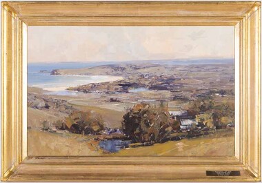 Wangaratta Art Gallery
Painting, Ken Knight, Coastal Vista, c. 1992
Knight’s art style is heavily influenced by the Australian Impressionist movement of the late 19th century and he paints his work in outdoor settings, which is known as plein-air painting. Rural City of Wangaratta Collection, Wangaratta Art Prize Grand Winner 1992.An aerial landscape of a costal view painted in oil using a tonal colour palette of browns, blues, greens, oranges, and whites.Obverse: KEN KNIGHT/ (bottom right corner) WANGARATTA ART SHOW/ GRAND WINNER 1992/ 'COASTAL VISTA'/ By KEN KNIGHT/ (plaque mounted on frame)wangaratta art gallery, ken knight, landscape, painting, costal, plein-air, plein air -
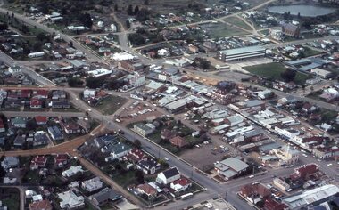
Stawell Historical Society Inc
Photograph - Large Print, Aerial View of Pleasant Creek Training Centre and North Western Woolen Mills, c1975
... Aerial View of Pleasant Creek Training Centre and North.... Aerial View of Pleasant Creek Training Centre and North Western ...Taken when buildings were at their peak. Referred to as Pleasant Creek Training Centre or Pleasant Creek Special SchoolMainly yellow coloured with Pleasant Creek Training Centre in middle and with Stawell North Western Woolen Mills at top right.VIC 25996 A1x10.3 QASCO VIC IMAGE 03 9682 3330education, manufacturing -
 Stawell Historical Society Inc
Photograph - Slides, Ian McCann, Aerial View 1976, 1976 - 1984
... Aerial View 1976... grampians Aerial Colour Photograph of Stawell Aerial View 1976 ...Aerial Colour Photograph of Stawell -
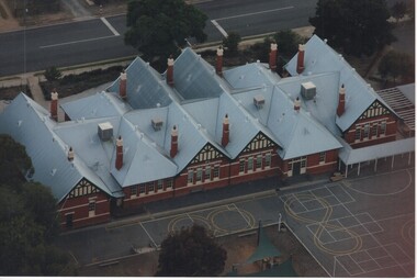 Rutherglen Historical Society
Photograph - Aerial Images, c2000
Photograph was probably taken sometime before 2007, as another photo in this series does not show the "Big Red Shed" behind the school. That building is shown on Google Street View shots taken in 2007. Rutherglen Common School No. 522, which is now the Common School Museum, would be to the left of the current school in the photo.Colour aerial photograph of Rutherglen Primary School No. 522, showing the rear of the building and its rooftop.rutherglen primary school, rutherglen state school, school buildings -
 Rutherglen Historical Society
Photograph - Aerial Images, c2000
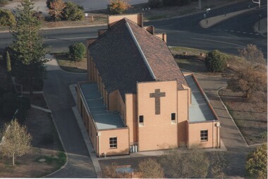
View is of the rear of St Mary's Catholic Church, RutherglenColour aerial photograph of the rear of the Catholic Church in Rutherglenst marys church, church buildings, churches -
 Rutherglen Historical Society
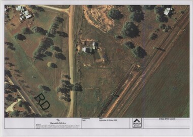
Image, Indigo Shire Council, 28/10/2009
When operational, the Gold Battery used cyanide in its processing processes. The land surrounding it required remediation before it could be handed over to Indigo Shire for public use. The land has since been planted with pasture and native plants. The Gold Battery has been restored to working condition, and can be viewed by collecting a ticket from the Rutherglen Wine Experience and Visitor Information Centre.Laminated aerial photograph of Gold Battery site, believed taken before land remediation.gold battery, gold processing