Showing 6308 items
matching housing
-
 Hume City Civic Collection
Photograph
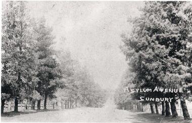
This is a photograph of The Avenue leading to the Sunbury Asylum. it is lined with pine trees and post and rail fences. At some stage oak trees were also planted along the avenue. In the late 1990s the trees along the west side of The Avenue were removed as a result of housing development. They were later replaced.A black and white photograph of a tree lined avenue Unmounted.Written on the photo: Asylum Avenue/ Sunburysunbury asylum, trees, fences, the avenue, george evans collection -
 Ballarat Tramway Museum
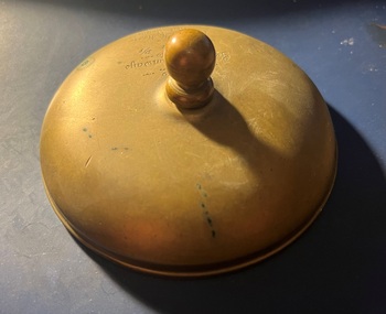
Functional object - Conductor Bell Geelong - Presentation engraved, State Electricity Commission of Victoria (SECV), 1956
Presentation to D J Irwin, the Depot Foreman at Geelong following the operation of the last tram No. 4 on 24 March 1956. Mr Irwin subsequently became the Depot Foreman in Ballarat. Would appear that the threaded knob is not part of the original conductor's bell as it does not fully screw into the bell housing.Demonstrates a presentation to depot staff at the time of the closure of the Geelong system.Part of conductors bell - brass fitted with a brass threaded knob.Engraved "SEC Geelong Tramways Pres to D J Irwin D/F by BTS J Moore, Last tram 24-3-1956"geelong, depot foreman, closure, conductors bell, d j irwin, j m moore -
 Bendigo Historical Society Inc.
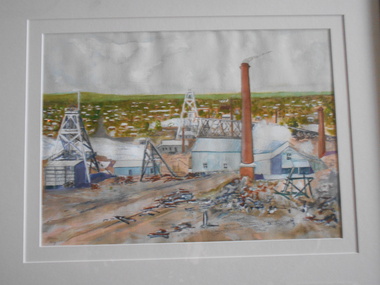
Painting - JOHN HALL COLLECTION: GOLDEN SQUARE MINES, 2013
Watercolour painting of Golden Square area, framed in gold timber frame with cream mount. Painting shows poppet heads and mining chimneys in foreground, housing in background. Pasted on back of frame is copy of print showing names of some of the mines. From left to right: Lazarus Mine, Lily Street; George Lansell's 222, Chum Street; New Chum Railway Mine (one of the deepest). Names presumably written by John Hall, artist.John Hallbendigo, mining, golden square -
 Bendigo Historical Society Inc.
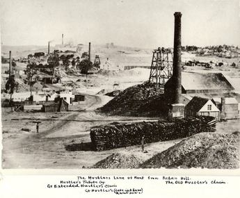
Photograph - HUSTLER'S LINE OF REEF
Black and white photograph of mining landscape with poppet head, chimney and mining sheds (plus timber in stack) in foreground. Other mines in bare landscape on LHS background and housing on RHS background. Inscriptions: on front - 'The Hustler's Line of Reef from Redan Hill Hustler's Tribute Coy', 'Gt. Extended Hustler;s Claim', 'The Old Hustler's Claim, Gt. Hustlers (Late Latham & Watson's). On back - 'A Richardson, 29 Harrison Street, Bendigo'.mine, gold, hustlers reef mine, bendigo, mines and mining, mine, mines, mining, landscape, mining landscape, redan hill, poppet head, old hustlers, mining cottages -
 Stanley Athenaeum & Public Room
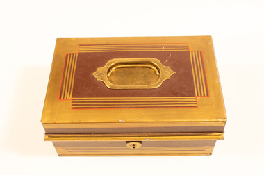
Container - Cash Box brown & gold, Cash Box - tin
Tin box in brown and gold square design '170016'. Gold painted outside with red stripe housing brown lines with solid brown area where brass handles attached. Lockable. Black interior paint. 3 money sections, detachable as a whole. Each section has a lid with a small handle. storage room underneath. Hinged lid (patent 4489?0 and 'note' storage below. Exterior handles both sides. Patent 4489? -
 Tennis Australia
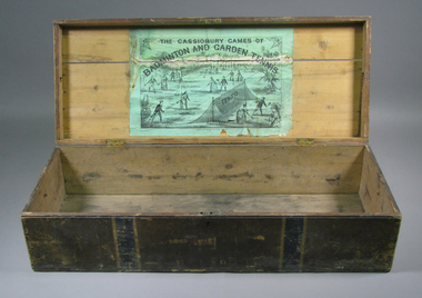
Chest, Circa 1876
An empty chest, originally housing a lawn tennis and badminton set. Black and green lithographic print features couples playing mixed doubles tennis and badminton in Cassiobury Park, with Cassiobury House in the background. Inscription: THE CASSIOBURY GAMES OF/BADMINTON AND GARDEN TENNIS/LONDON/DEAN & SON 160 FLEET STREET. The hourglass court used in Wingfield's version of lawn tennis is depicted in this lithograph. Materials: Wood, Metal, Ink, Glue, Paint, Paper, Lacquertennis -
 Maldon Vintage Machinery Museum Inc
Sewing Machine
Singer sewing machine with electric motor and maroon hard cover. Instruction book for No. 66 Singer Sewing Machine - greenpaper cover with red logo on front, 32 pages. Hinged wooden flap forms table when lowered. Machine housing is metal painted fawn with brown drive wheel & foot pedal. Motor is also brown. Base is cream. Cover has cream handle & brass catches. Accessories box R.N. 31.10.Motor serial No K10591526singer; sewing machines; domestic items; handcrafts -
 Bendigo Historical Society Inc.
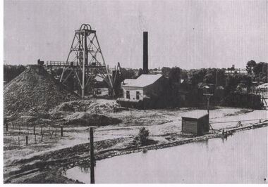
Photograph - BLACK AND WHITE PHOTOGRAPH OF THE NORTH DEBORAH MINE
North Deborah Mine in Eve Street, Bendigo, operated between 1937 and 1954. In that time it produced 128,000 ounces of gold.Black and white photograph of the North Deborah Mine, showing the poppet head, mullock heap to the left, man at the end of railway at the first level, does not show cables from the engine house to the wheels on top of the poppet, water tank at the side of the engine house, farm style corner of a fence at left of photo, small shed housing a pump for water, right foreground is a dam for water waiting to be converted to steam to operate the cable winder.mining, surface equipment, north deborah mine -
 Eltham District Historical Society Inc
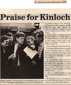
Drawing - Newspaper clipping, Praise for Kinloch, Diamond Valley News, April 8, 1998, p11, April 1998
PLANNING Minister Rob Maclellan and Nillumbik Shire president Robert Marshall have both praised an innovative housing development on a historic property east of Eltham's town centre. Both were present at the launch of the Kinloch Gardens development, where 12 new double and triple storey homes will be built along a private road in the gardens of Kinloch, a mansion set on 2.4ha in Arthur St. About 100 people attended the launch. Cr Marshall likened Kinloch Gardens to the Woodridge Estate at Eltham, which he said provided housing on small allotments while protecting much of the tree canopy, and "showed how a suburb can be built". He said Kinloch could easily have been subdivided, with a court running up the middle of the development, but the owners, the Jelbart family, opted instead for a private road on the property, sweeping around a common pond and 'village green'. ''This is a perfect example of what can be achieved in urban planning,'' he said. Mr Maclellan said the development was one of the most impressive he had seen in his role as Planning Minister Picture - Historic launch: Planning Minister Rob Maclellan (left) on a visit to Eltham last week to help launch a new housing development.Digital file only; created from scan undertaken by EDHS of item on loanarthur street, eltham, graeme gunn, houses, ian jelbart, jelbart property, kinloch gardens, rob maclellan, robert marshall, woodridge estate -
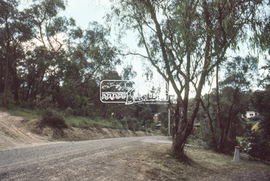
 Eltham District Historical Society Inc
Slide, Roundabout at Reichelt Avenue and McCarthy Grove, Montmorency, c.Oct. 1980
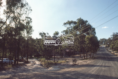
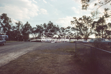
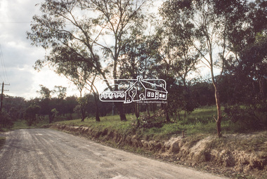
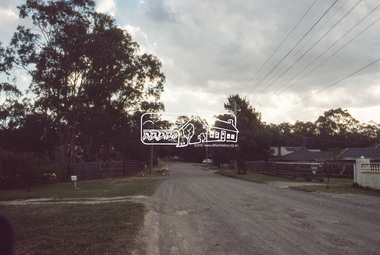
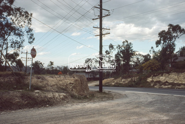
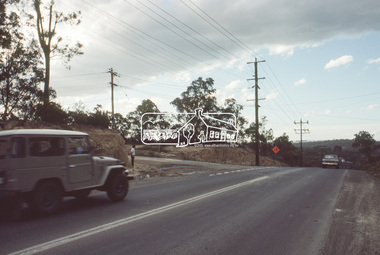
One of a series of images of roads and infrastructure focussed on the Quinn Estate in Montmorency taken by Eltham Shire Council Planning and Engineering officers. They provide perspective of the changes in housing styles and road development that began sweeping in from the mid 1970s with increasing urbanisation of what was once more outlying suburbs and regions.35 mm colour positive transparency Mount - Kodak Kodachrome CardProcessed Oct 1980infrastructure, mccarthy grove, montmorency, reichelt avenue, roads, roundabout -
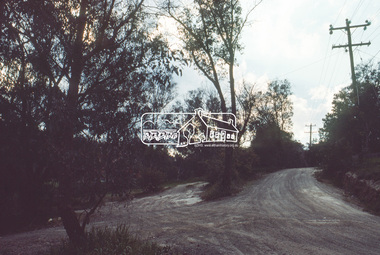
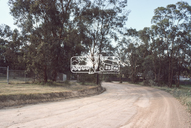 Eltham District Historical Society Inc
Slide, Mitchell Avenue near Panorama Heights Preschool, Montmorency, c.Oct. 1980
One of a series of images of roads and infrastructure focussed on the Quinn Estate in Montmorency taken by Eltham Shire Council Planning and Engineering officers. They provide perspective of the changes in housing styles and road development that began sweeping in from the mid 1970s with increasing urbanisation of what was once more outlying suburbs and regions.35 mm colour positive transparency Mount - Kodak Kodachrome CardProcessed Oct 1980infrastructure, mitchell avenue, montmorency, panorama heights preschool, roads -
 Eltham District Historical Society Inc
Slide, Mitchell Avenue looking towrads Montmorency South Primary School, c.Oct. 1980
One of a series of images of roads and infrastructure focussed on the Quinn Estate in Montmorency taken by Eltham Shire Council Planning and Engineering officers. They provide perspective of the changes in housing styles and road development that began sweeping in from the mid 1970s with increasing urbanisation of what was once more outlying suburbs and regions.35 mm colour positive transparency Mount - Kodak Kodachrome CardProcessed Oct 1980infrastructure, mitchell avenue, montmorency, montmorency south primary school, roads -
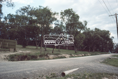
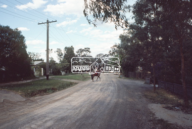 Eltham District Historical Society Inc
Slide, Looking east along Buena Vista Drive, Montmorency near no. 69, c.Oct. 1980
One of a series of images of roads and infrastructure focussed on the Quinn Estate in Montmorency taken by Eltham Shire Council Planning and Engineering officers. They provide perspective of the changes in housing styles and road development that began sweeping in from the mid 1970s with increasing urbanisation of what was once more outlying suburbs and regions.35 mm colour positive transparency Mount - Kodak Kodachrome CardProcessed Oct 1980buena vista drive, horse, infrastructure, montmorency, roads -
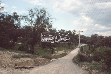
 Eltham District Historical Society Inc
Slide, Quinn Estate, Buena Vista Drive, Montmorency near school looking northwest, c.Oct. 1980
One of a series of images of roads and infrastructure focussed on the Quinn Estate in Montmorency taken by Eltham Shire Council Planning and Engineering officers. They provide perspective of the changes in housing styles and road development that began sweeping in from the mid 1970s with increasing urbanisation of what was once more outlying suburbs and regions.35 mm colour positive transparency Mount - Kodak Kodachrome CardProcessed Oct 1980housing estate, infrastructure, montmorency, quinn estate, roads -
 Eltham District Historical Society Inc
Slide, Looking north along Buena Vista Drive near Montmorency South Primary School, c.Oct. 1980
One of a series of images of roads and infrastructure focussed on the Quinn Estate in Montmorency taken by Eltham Shire Council Planning and Engineering officers. They provide perspective of the changes in housing styles and road development that began sweeping in from the mid 1970s with increasing urbanisation of what was once more outlying suburbs and regions.35 mm colour positive transparency Mount - Kodak Kodachrome CardProcessed Oct 1980buena vista drive, infrastructure, montmorency, montmorency south primary school, roads -
 Eltham District Historical Society Inc
Slide, Quinn Estate looking east along Cressy Streett, Montmorency before Quinn Way, c.Oct. 1980
One of a series of images of roads and infrastructure focussed on the Quinn Estate in Montmorency taken by Eltham Shire Council Planning and Engineering officers. They provide perspective of the changes in housing styles and road development that began sweeping in from the mid 1970s with increasing urbanisation of what was once more outlying suburbs and regions.35 mm colour positive transparency Mount - Kodak Kodachrome CardProcessed Oct 1980infrastructure, montmorency, cressy street, housing estate, quinn estate, quinn way, roads -
 Eltham District Historical Society Inc
Slide, Quinn Estate from Sackville Street looking west to 'T-bowl' near Main Road, Montmorency, c.Oct. 1980
One of a series of images of roads and infrastructure focussed on the Quinn Estate in Montmorency taken by Eltham Shire Council Planning and Engineering officers. They provide perspective of the changes in housing styles and road development that began sweeping in from the mid 1970s with increasing urbanisation of what was once more outlying suburbs and regions.35 mm colour positive transparency Mount - Kodak Kodachrome CardProcessed Oct 1980roads, housing estate, infrastructure, main road, montmorency, quinn estate, sackville street, t-bowl -
 Eltham District Historical Society Inc
Slide, Quinn Estate, looking northeast along Sackville Street, Montmorency near no. 12, c.Oct. 1980
One of a series of images of roads and infrastructure focussed on the Quinn Estate in Montmorency taken by Eltham Shire Council Planning and Engineering officers. They provide perspective of the changes in housing styles and road development that began sweeping in from the mid 1970s with increasing urbanisation of what was once more outlying suburbs and regions.35 mm colour positive transparency Mount - Kodak Kodachrome CardProcessed Oct 1980infrastructure, housing estate, montmorency, quinn estate, roads, sackville street -
 Eltham District Historical Society Inc
Slide, Sackville Street, Montmorency; split road near no. 36, c.Oct. 1980
One of a series of images of roads and infrastructure focussed on the Quinn Estate in Montmorency taken by Eltham Shire Council Planning and Engineering officers. They provide perspective of the changes in housing styles and road development that began sweeping in from the mid 1970s with increasing urbanisation of what was once more outlying suburbs and regions.35 mm colour positive transparency Mount - Kodak Kodachrome CardProcessed Oct 1980sackville street, infrastructure, montmorency, roads -
 Eltham District Historical Society Inc
Slide, Quinn Estate looking east along Sackville Street just prior to Quinn Way, Montmorency, c.Oct. 1980
One of a series of images of roads and infrastructure focussed on the Quinn Estate in Montmorency taken by Eltham Shire Council Planning and Engineering officers. They provide perspective of the changes in housing styles and road development that began sweeping in from the mid 1970s with increasing urbanisation of what was once more outlying suburbs and regions.35 mm colour positive transparency Mount - Kodak Kodachrome CardProcessed Oct 1980roads, housing estate, infrastructure, montmorency, quinn estate, quinn way, sackville street -
 Eltham District Historical Society Inc
Slide, Quinn Estate near Sackville Reserve, Montmorency, c.Oct. 1980
One of a series of images of roads and infrastructure focussed on the Quinn Estate in Montmorency taken by Eltham Shire Council Planning and Engineering officers. They provide perspective of the changes in housing styles and road development that began sweeping in from the mid 1970s with increasing urbanisation of what was once more outlying suburbs and regions.35 mm colour positive transparency Mount - Kodak Kodachrome CardProcessed Oct 1980quinn estate, housing estate, infrastructure, montmorency, roads, sackville reserve, sackville street -
 Eltham District Historical Society Inc
Slide, Reichelt Avenue, Montmorency at intersection with Bolton Street (now closed), c.Oct. 1980
One of a series of images of roads and infrastructure focussed on the Quinn Estate in Montmorency taken by Eltham Shire Council Planning and Engineering officers. They provide perspective of the changes in housing styles and road development that began sweeping in from the mid 1970s with increasing urbanisation of what was once more outlying suburbs and regions.35 mm colour positive transparency Mount - Kodak Kodachrome CardProcessed Oct 1980bolton steet, eltham, infrastructure, montmorency, reichelt avenue, roads -
 Eltham District Historical Society Inc
Slide, Quinn Estate, Reichelt Avenue near Riverina Road, Montmorency, c.Oct. 1980
One of a series of images of roads and infrastructure focussed on the Quinn Estate in Montmorency taken by Eltham Shire Council Planning and Engineering officers. They provide perspective of the changes in housing styles and road development that began sweeping in from the mid 1970s with increasing urbanisation of what was once more outlying suburbs and regions.35 mm colour positive transparency Mount - Kodak Kodachrome CardProcessed Oct 1980housing estate, infrastructure, montmorency, quinn estate, reichelt avenue, roads -
 Eltham District Historical Society Inc
Slide, Quinn Estate, Buena Vista Drive, Montmorency near school looking northwest, c.Oct. 1980
One of a series of images of roads and infrastructure focussed on the Quinn Estate in Montmorency taken by Eltham Shire Council Planning and Engineering officers. They provide perspective of the changes in housing styles and road development that began sweeping in from the mid 1970s with increasing urbanisation of what was once more outlying suburbs and regions.35 mm colour positive transparency Mount - Kodak Kodachrome CardProcessed Oct 1980housing estate, infrastructure, montmorency, quinn estate, roads -
 Eltham District Historical Society Inc
Slide, Quinn Estate looking west along Cressy Street, Montmorency, c.Oct. 1980
One of a series of images of roads and infrastructure focussed on the Quinn Estate in Montmorency taken by Eltham Shire Council Planning and Engineering officers. They provide perspective of the changes in housing styles and road development that began sweeping in from the mid 1970s with increasing urbanisation of what was once more outlying suburbs and regions.35 mm colour positive transparency Mount - Kodak Kodachrome CardProcessed Oct 1980cressy street, housing estate, infrastructure, montmorency, quinn estate, roads -
 Eltham District Historical Society Inc
Slide, Quinn Estate looking west along Cressy Street, Montmorency near no. 29, c.Oct. 1980
One of a series of images of roads and infrastructure focussed on the Quinn Estate in Montmorency taken by Eltham Shire Council Planning and Engineering officers. They provide perspective of the changes in housing styles and road development that began sweeping in from the mid 1970s with increasing urbanisation of what was once more outlying suburbs and regions.35 mm colour positive transparency Mount - Kodak Kodachrome CardProcessed Oct 1980cressy street, housing estate, infrastructure, montmorency, quinn estate, roads -
 Eltham District Historical Society Inc
Slide, Quinn Estate, looking along Cressy Street towards Quinn Way, Montmorency, c.Oct. 1980
One of a series of images of roads and infrastructure focussed on the Quinn Estate in Montmorency taken by Eltham Shire Council Planning and Engineering officers. They provide perspective of the changes in housing styles and road development that began sweeping in from the mid 1970s with increasing urbanisation of what was once more outlying suburbs and regions.35 mm colour positive transparency Mount - Kodak Kodachrome CardProcessed Oct 1980quinn estate, cressy street, housing estate, infrastructure, montmorency, roads -
 Eltham District Historical Society Inc
Slide, Reichelt Avenue, Montmorency at T-bowl near no. 27, c.Oct. 1980
One of a series of images of roads and infrastructure focussed on the Quinn Estate in Montmorency taken by Eltham Shire Council Planning and Engineering officers. They provide perspective of the changes in housing styles and road development that began sweeping in from the mid 1970s with increasing urbanisation of what was once more outlying suburbs and regions.35 mm colour positive transparency Mount - Kodak Kodachrome CardProcessed Oct 1980infrastructure, montmorency, reichelt avenue, roads, t-bowl -
 Eltham District Historical Society Inc
Slide, Intersection of Reichelt Avenue, Montmorency at Bolton Street, c.Oct. 1980
One of a series of images of roads and infrastructure focussed on the Quinn Estate in Montmorency taken by Eltham Shire Council Planning and Engineering officers. They provide perspective of the changes in housing styles and road development that began sweeping in from the mid 1970s with increasing urbanisation of what was once more outlying suburbs and regions.35 mm colour positive transparency Mount - Kodak Kodachrome CardProcessed Oct 1980infrastructure, bolton steet, eltham, montmorency, reichelt avenue, roads -
 Eltham District Historical Society Inc
Slide, Intersection of Reichelt Avenue, Montmorency at Bolton Street, c.Oct. 1980
One of a series of images of roads and infrastructure focussed on the Quinn Estate in Montmorency taken by Eltham Shire Council Planning and Engineering officers. They provide perspective of the changes in housing styles and road development that began sweeping in from the mid 1970s with increasing urbanisation of what was once more outlying suburbs and regions.35 mm colour positive transparency Mount - Kodak Kodachrome CardProcessed Oct 1980infrastructure, bolton steet, eltham, montmorency, reichelt avenue, roads