Showing 1230 items
matching information board
-
 Ballarat Tramway Museum
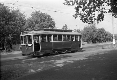
Negative, Wal Jack, late 1940's or early 1950's
Yields information about the tram services and the intersection of Sturt St West and Russell Sts.Negative and Digital image of the Wal Jack Ballarat Negative file of No. 14 in Sturt St West, near the intersection with Russell St., with a auxiliary board, "Victoria Park". Tram has the destination of City. In the background is the Loreto Convent wall.trams, tramways, sturt st west, russell st, victoria park, tram 14 -
 Ballarat Tramway Museum
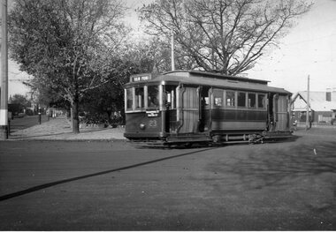
Negative, Wal Jack, late 1940's
Yields information about the tram services to View Point and the Ripon St intersection.Negative and Digital image of the Wal Jack Ballarat Negative file of No. 23 turning from Sturt St into Ripon St, with the destination of View Point. Tram has an auxiliary board "Macarthur St via Ripon St" Possibly late 1940's as the tram is in the prewar colour scheme.trams, tramways, sturt st, view point, ripon st, tram 23 -
 Ballarat Tramway Museum
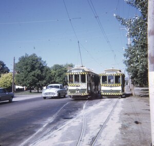
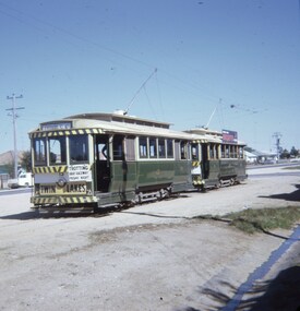
Slide - 27 mm sq slide/s, Andrew Howlett, Nos. 34 and 26 crossing at the Parked St loop in Sturt St west loop, Mar. 1969
Yields information about the Sturt St West Parker St Loop.Colour slide, Kodak white cardboard mount, developed March 1969 of Nos. 34 and 26 crossing at the Parked St loop in Sturt St west loop. No. 34 is heading for Mt Pleasant and has a Trotting at Bray Raceway auxiliary board and No. 26 running a Special. Shows how's the motor vehicle traffic had to veer out past trams. One of a series of tour photos - see Reg item 7667, 7668, 7683 and 7701.Has in red ink "Sturt St Loop"ballarat, tramways, trams, sturt st west, parker st loop, tram 26, tram 34 -
 Ballarat Tramway Museum
Slide - 27 mm sq slide/s - set of 3, Andrew Howlett, Lydiard St North level crossing, March 1969?
Yields information about the Lydiard St Nth line, the level crossing and the terminus.Set of three Colour slides, Kodak white cardboard mount, developed Mar 1969 of No. 37 .1 - while running a special crossing at the Lydiard St North level crossing at the Railway Station. Has the Reid's Coffee Palace and Railway Station in the background. .2 - No. 37 and a single trucker carrying a "Trotting at Bray Raceway" auxiliary board, at the Lydiard St North terminus. Has the shelter on the right-hand side. .3 - No. 37 waiting at the terminus. See Reg Items 7675, 7678, 7681, 7684, 7686, 7705 and 7713.ballarat, tramways, trams, lydiard st nth, railway station, shelters, level crossings, tram 37 -
 Ballarat Tramway Museum
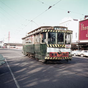
Slide - 27 mm sq slide/s, Andrew Howlett, Tram No. 13 at the Sebastopol terminus, Mar. 1969
Yields information about the Sebastopol line and the terminus and tram services.Colour slides, Kodak white cardboard mount, developed March 1969 of No. 13 at the Sebastopol terminus with possibly No. 26 behind, given the slide sequence number. No. 13 has the destination of Lydiard St North and is carrying an Auxiliary board "Trotting Bray Raceway Friday Night" and has a Twin Lakes sign."Sebastopol term" in red ink.ballarat, tramways, trams, albert st, tours, sebastopol, tram 13 -
 Ballarat Tramway Museum
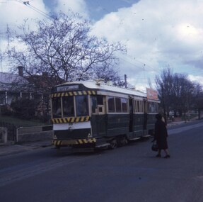
Slide - 27 mm sq slide/s, Andrew Howlett, Sep. 1968
Yields information about tram services in Barkly St and passengers.Colour slide, Kodak white cardboard mount, developed Sept 1968, of No. 38 in Barkly St Mt Pleasant with a lady walking over to board the tram. Tram has the destination of Gardens via Drummond North."Mt Pleasant" in red ink.ballarat, tramways, trams, mt pleasant, barkly st, passengers, tram 38 -
 Ballarat Tramway Museum
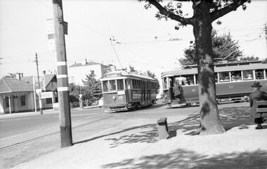
Negative, Wal Jack, 1956?
Yields information about Ballarat tram operations possibly during the 1956 Olympics.Negative and Digital images of the Wal Jack Ballarat Negative file of trams 36 (Mt Pleasant, with an auxiliary board) and No. 30 meeting at Hospital Corner. No. 30 is about to enter Drummond St North. The style of the auxiliary board on No. 36 is similar to that used on trams during the Olympic Games. In the background is the Shell Service Station.trams, tramways, hospital corner, olympics, drummond st nth, tram 30 tram 36 -
 Bendigo Historical Society Inc.
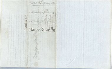
Legal record - Power of Attorney, 18/02/1862
Captain Mackenzie Luckie was born in 1821. From 1853 he commanded eight ships. He died on board the Michael Angelo off the coast of New Zealand in February 1875. After the ship arrived in Nelson, The Argus (Melbourne) reported on 12 February 1875 that Captain Luckie was found dead in his cabin, from heart disease. His appointed Attorney Mr George William Knight selected land in Sunbury in 1860 and then arrived in Bendigo on 2 April 1870. For more information about George William Knight see https://trove.nla.gov.au/newspaper/article/227853797?searchTerm=george%20william%20knightCaptain McKenzie Luckie a. Document appointing George William Knight of Sunbury or elsewhere in the Colony of Victoria as a lawful attorney to act for Mackenzie Luckie of 15 Tredegar Square, Bow in the County of Middlesex (now London), Master Mariner. Dated 18 February 1862. Witnessed by William Charles White. Five page document - two blue flimsy sheets, one light card sheet and two grey flimsy sheets. b. Transcript from The Age (Melbourne) 27 November 1937. The letter from H. Daniel, Monte Video, South America, is responding to an earlier letter from the grand daughter of Captain Mackenzie Luckie. It includes a record of the career of Captain Luckie from 1853. captain mackenzie luckie, master mariner -
 Bendigo Historical Society Inc.
Letter - Message in a Bottle
In 1915 Arthur Swanwick from Bendigo enlisted in the AIF. He left for overseas service in March 1916. He wrote a message to his sweetheart Jessie Campbell, placed it in a bottle and threw it overboard from HMAT A18 "Wiltshire". The bottle was found on a beach near Robe SA and the message was sent to Jessie. Arthur returned home and he and Jessie married in 1918. Arthur died on 11 April 1968. Arthur's niece sent the updated information after the story was shared with the family who knew nothing about it. A hand written letter on lined green paper sent to BHS providing an update on the story of a "Message in a Bottle" written by Arthur Swanwick to Jessie Campbell. A black and white wedding photograph of Arthur and Jessie, a black and white photograph of dedication plaques from the Bendigo RSL WW1 Honour Board and a Thank you card form Arthur's niece thanking someone for letting the family know about the story (18 October 2013). ww1, message in a bottle, swanick -
 Ballarat Tramway Museum
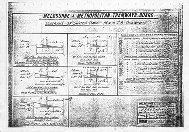
Drawing - MMTB Trackwork drawings, Melbourne and Metropolitan Tramways Board (MMTB)
Prepared by the MMTB for the design of pointwork or switches.Yields information on the design of trackwork.Set of two MMTB Drawings of Switches, points and turnout details .1 - P3738 - Diagrams of Switch Data - actual switch blades - dated 30-10-1926 .2 - P9312 - Lorains No. 3 Switch Spiral Transition - dated 5/6/1942.2 - dated stamped 5 July 1974trackwork, points, switches, mmtb, tramways -
 Ballarat Tramway Museum
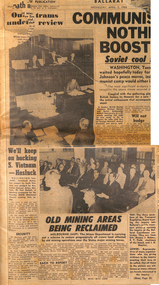
Newspaper, The Courier Ballarat, Our trams under review - The Courier, Ballarat, 3 and 4 April 1968
Provides information about the two-day enquiry held by the Victorian Transport Regulation board into the SEC operated Ballarat Tramway system. Enquiry held at the Ballarat Court House, by Messrs J Bolster, E V Field (Chairman) and J O Mactier of the TRB. Two photos show the Board and some of the attendees. Page 2 of the 3 April report; the acting assistant manager of the SEC advised that the tramway was unsafe, deaths due to collisions with trams, costs of refurbishing the tracks and tramcars and employment issues. Evidence was also given by the Mayor of Ballarat, Cr. Nicholson, Ballarat Town Clerk Mr Maddern, Barry Wilkins, H A Davis local bus operators. The Board considered whether the existing services could be replaced by private operators, or a publicly operated service, including the cost of operators. Also submissions from Mr O'Shea of the ATOMEA, Ballarat Trams and Labor Council, and Chamber of Manufacturers. At the time, the Government did not have the numbers in the upper house to close the system. Yields information about an 1968 enquiry into the closure of the Ballarat Tramway system. Set of two newspaper cuttings from The Courier, Ballarat 3 and 4 April 1968 about a Transport Regulation enquiry.trams, tramways, ballarat, closure, transport regulation board, trb, enquiry, atomea, sec, secv -
 Ballarat Tramway Museum
Newspaper, City of Ballarat Notice board - Tender Advertisements - 20-2-2022
Tender advertisement for the track replacement in Wendouree Parade and construction of the new Museum depot fan. The same advertisement appeared 1 week later. Yields information about the tender for the track replacement in Wendouree Parade.City of Ballarat Notice board - Tender Advertisements - 20-2-2022 obtained from the Ballarat Times News Group newspaper.btm, track replacement, wendouree parade, track work, new museum, tenders -
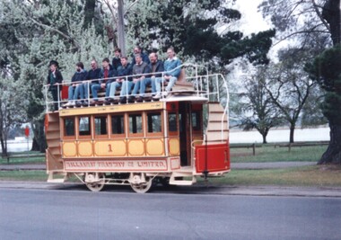 Ballarat Tramway Museum
Photograph - Ballarat - Horse tram prelaunch test in Wendouree Parade, Ian Stanley, 18-10-1992
... deck are Board members. Yields information about BTPS ...Photos shows horse tram No. 1 in Wendouree Parade prior to its launch on 7-11-1992 undertaking as safety test in Wendouree Parade. Most of the people on the top deck are Board members.Yields information about BTPS Operations and work in 1992.Colour print of Kodak paper - Ballarat - Horse tram prelaunch test in Wendouree ParadeHas details of the location and dates on rear along with photographers number.ballarat, tramways, tramcars, btps, horse tram, tram 1, wendouree parade -
 Ballarat Tramway Museum
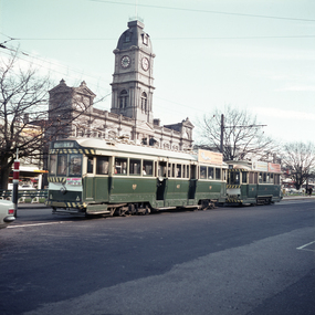
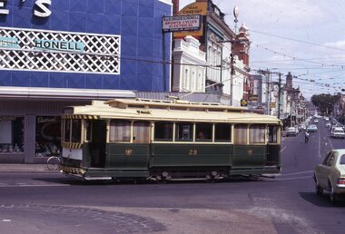
Photograph - Colour print - tram 33 City Loop, Barry Pemberton, July 1970
Photo shows tram 33 parked in the City loop during an afternoon early to July 1970 The tram has a Twin Lakes sign and the destination of Mt Pleasant, along with an auxiliary board advertising "Alf Garnet at the Vegas 70 Cinema". In the background is the Dickins Food store and Thomas Jewellers. Note the Section Insulators above the tram on both tracks.Yields information about tram operations and advertising July 1970.Colour print - digital printed made 12/22Has notes on the rear of the print about the photographer, address and dates.tramways, tramcars, tram 33, city loop, ballarat, alf garnett, section insulators -
 Ballarat Tramway Museum
Photograph - Colour print - trams 41 and 20, Barry Pemberton, July 1970
Photo shows tram 41 (Lydiard St Nth) and 20 stopped at the City terminus, corner of Lydiard and Sturt Streets. In the background is Ballarat Town Hall. Tram 41 has an auxiliary board advertising Alf Garnett at the Vegas 70 Cinema. Tram 20 was "destroyed" in a collision in Victoria Street during September 1970.Yields information about tram operations and advertising July 1970.Colour print - digital printed made 12/22Has notes on the rear of the print about the photographer, address and dates.tramways, tramcars, ballarat, alf garnett, sturt st, tran 41, tram 20 -
 Ballarat Tramway Museum
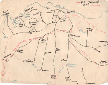
Drawing - Plan and notes, Wal Jack, Auckland NZ tramways, 1945
Wal Jack had an extensive range of correspondents throughout Australia and the world who often provided him with detailed drawings and notes on various tramway systems. This set of notes on the Auckland tramway system, both the main city, Auckland Tramway Board and the north shore - Takapuna Tramway and Ferry Co shows the various routes, locations and terminals. The hand written sheets provide opening dates of the various routes and gives the total miles and number of cars as at 31-3-1945. Based on the handwriting, prepared by Wal Jack himself.Yields information about Wal Jack's extensive recording and research work.Set of two drawings - black, red and blue ink on quarto size paper and two sheets of notes on the Auckland tramway system c1945.letters, wal jack, drawings, maps, auckland, takapuna nz -
 Ballarat Tramway Museum
Slide - Tram 28 Stones Corner, Richard Jones, Mar. 1970
Image shows Ballarat 28 at Stones corner en route to Mt Pleasant in Main St. The weather blinds, fully drawn are showing their age. In the background is Stones Corner store, a sign board K&O (Digger) Schonell Sports Cycles and Electrical and Gear Chemist.Yields information about Stones Corner and tram 28.Digital image of a Kodachrome slideballarat, trams, tramways, tram 28, main st, stones corner -
 Ballarat Tramway Museum
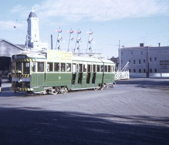
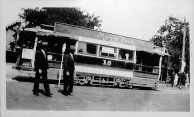
Photograph - Laminated - ESCo 18 Wendouree Parade
Photograph of Electric Supply Co. of Vic (ESCo) Ballarat tram 18 in Wendouree Parade with the Gardens Kiosk in the background. Tram has a roof advertisement for Monosylk hosiery. There is a safety zone sign and two gentlemen standing alongside. The safety zone and line markings are unusual in Ballarat where passengers alighted or boarded on the lake side of the roadway. A related item could be 5904 which shows ESCo tram 9 offloading passengers on the "wrong side" for Ballarat at this location and a sign in position. Possibly a special event or a trial. Photo possibly mid 1920sYields information about the use of a safety zone sign in Ballarat and tram 18Laminated laser print photograph black and whitesafety zone, wendouree parade, ballarat, tram 18, esco, events, monosvlk -
 Ballarat Tramway Museum
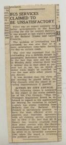
Newspaper, The Courier Ballarat, "Bus Services claimed to be unsatisfactory", c1950's
Yields information about Ballarat bus services to Waubra and issues.Newspaper clipping (undated) about bus services to country districts outside Ballarat in particular Waubra. Involves Trades and Labour Councils, City of Ballarat, and Transport Regulation Board. Mr. R. Emery ex RAN is mentioned. From The Courier? titled "Bus Services claimed to be unsatisfactory" Record updated and images added 21/8/2013.trams, tramways, ballarat rural bus services, waubra, transport regulations -
 Ballarat Tramway Museum
Document - Photocopies, Ballarat Tramway Museum (BTM), 277.1 - "Farewell Crawl", 277.2 - "Goodbye to Trams", Mar. 1996
Yields information about the history of Bendigo's trams, tramways and the trammies and their stories and a special tram prior to closure. Has a strong association with the businesses in Bendigo.Photocopies of Bendigo Advertiser newspaper. 277.1 - "Farewell Crawl" - report with photo of a group from the Court House Hotel who did a pub crawl by tram on Sat. April 8, 1972 - photo of group on board with tram No. 26. 277.2 - photocopy of the Bendigo Advertisers feature of 8 pages, called "Bendigo says Good-Bye to the trams". Features history of the Bendigo trams, the services, personal stories, photos and advertisements from local commerce - published Thursday April 13, 1972. Tram services closed the following Sunday. For original of the feature see item Reg. No. 1038. Pdf image of photocopies added 22/10/2013trams, tramways, bendigo, secv, closure -
 Ballarat Tramway Museum
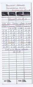
Document - Table Cards, Melbourne and Metropolitan Tramways Board (MMTB), 1979 Australia Day (29/1/1979) Cavalcade, Jan. 1979
Yields information about the arrangements for the Australia Day Cavalcades and the way crews were arranged.Heavy card printed as a M&MTB driver run table used for the 1979 Australia Day (29/1/1979) Cavalcade with BTPS tram No. 14. Gives time ex Preston and times ex Spencer & LaTrobe and ex Swanston and car in at Preston depot. In blue and red ink. Image of items added 2/11/13.trams, tramways, mmtb, btps, melbourne, australia day -
 Ballarat Tramway Museum
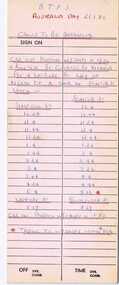
Document - Table Cards, Melbourne and Metropolitan Tramways Board (MMTB), Australia day (26/1/1980) cavalcade, Jan. 1980
Yields information about the arrangements for the Australia Day Cavalcades and the way crews were arranged.Heavy card printed as a M&MTB Driver's table, used for the Australia day (26/1/1980) cavalcade for BTPS No. 40. Gives time ex Preston, Spencer St (Flinders St.) and ex Simpson St shunt and times back to Preston workshops. In blue and red ink. Image of items added 2/11/13.trams, tramways, mmtb, btps, melbourne australia day -
 Kew Historical Society Inc
Plan, Melbourne & Metropolitan Board of Works : Borough of Kew : Detail Plan No.1576, 1904
The Melbourne and Metropolitan Board of Works (MMBW) plans were produced from the 1890s to the 1950s. They were crucial to the design and development of Melbourne's sewerage and drainage system. The plans, at a scale of 40 feet to 1 inch (1:480), provide a detailed historical record of Melbourne streetscapes and environmental features. Each plan covers one or two street blocks (roughly six streets), showing details of buildings, including garden layouts and ownership boundaries, and features such as laneways, drains, bridges, parks, municipal boundaries and other prominent landmarks as they existed at the time each plan was produced. (Source: State Library of Victoria)This plan forms part of a large group of MMBW plans and maps that was donated to the Society by the Mr Poulter, City Engineer of the City of Kew in 1989. Within this collection, thirty-five hand-coloured plans, backed with linen, are of statewide significance as they include annotations that provide details of construction materials used in buildings in the first decade of the 20th century as well as additional information about land ownership and usage. The copies in the Public Record Office Victoria and the State Library of Victoria are monochrome versions which do not denote building materials so that the maps in this collection are invaluable and unique tools for researchers and heritage consultants. A number of the plans are not held in the collection of the State Library of Victoria so they have the additional attribute of rarity.Original survey plan, issued by the MMBW to a contractor with responsibility for constructing sewers in the area identified on the plan within the Borough of Kew. The plan was at some stage hand-coloured, possibly by the contractor, but more likely by officers working in the Engineering Department of the Borough and later Town, then City of Kew. The hand-coloured sections of buildings on the plan were used to denote masonry or brick constructions (pink), weatherboard constructions (yellow), and public buildings (grey). Development in the 20th century has irreparably altered that part of Kew represented in this plan. In the block bounded by Cotham Road, Charles Street, Wellington Street and Gellibrand; just one house standing in 1903 remains. This block included two of the most historic houses in Kew: ‘Ordsall’ (later ‘Southesk’) and ‘Madford’ (previously ‘Elm Lodge’). Ordsall was the home of the second chairman of Kew, John Halfey. It contained some of the most significant interior murals in Kew, created for Halfey by artists working for Cullen & Co. It was demolished in 1960 to make way for the Kew Civic Centre. Elm Lodge had been built for William Siddeley in ca. 1864. Arthur Septimus King purchased it in 1874. The lower paddocks of Madford were sold in 1905 by his wife to the Borough of Kew and, after landscaping by George and Thomas Pockett, opened as the Alexandra Gardens in 1908. Elm Lodge/Madford was in 1922 to become St. Anthony’s Home for Little Children before its subsequent demolition in the 1980s.melbourne and metropolitan board of works, detail plans, maps - borough of kew, mmbw 1576, cartography -
 Kew Historical Society Inc
Plan, Borough of Kew Detail Plan No.1577, 1904
The Melbourne and Metropolitan Board of Works (MMBW) plans were produced from the 1890s to the 1950s. They were crucial to the design and development of Melbourne's sewerage and drainage system. The plans, at a scale of 40 feet to 1 inch (1:480), provide a detailed historical record of Melbourne streetscapes and environmental features. Each plan covers one or two street blocks (roughly six streets), showing details of buildings, including garden layouts and ownership boundaries, and features such as laneways, drains, bridges, parks, municipal boundaries and other prominent landmarks as they existed at the time each plan was produced. (Source: State Library of Victoria)This plan forms part of a large group of MMBW plans and maps that was donated to the Society by the Mr Poulter, City Engineer of the City of Kew in 1989. Within this collection, thirty-five hand-coloured plans, backed with linen, are of statewide significance as they include annotations that provide details of construction materials used in buildings in the first decade of the 20th century as well as additional information about land ownership and usage. The copies in the Public Record Office Victoria and the State Library of Victoria are monochrome versions which do not denote building materials so that the maps in this collection are invaluable and unique tools for researchers and heritage consultants. A number of the plans are not held in the collection of the State Library of Victoria so they have the additional attribute of rarity.Original survey plan, issued by the MMBW to a contractor with responsibility for constructing sewers in the area identified on the plan within the Borough of Kew. The plan was at some stage hand-coloured, possibly by the contractor, but more likely by officers working in the Engineering Department of the Borough and later Town, then City of Kew. The hand-coloured sections of buildings on the plan were used to denote masonry or brick constructions (pink), weatherboard constructions (yellow), and public buildings (grey). MMBW Plan No.1577 includes some of the most significant houses in Kew: Herbert Henty’s ‘Roxeth’ (now part of Trinity Grammar), ‘Butleigh Wooton’, ‘Bokara’ and ‘Harrow’. It also includes the streets that have since changed their names. That part of College Parade linked to Glenferrie Road is now named College Place, College Parade now extends further north, and Charles Street did not yet reach Barkers Road. Roxeth is one of a number of Henty houses in Kew. Herbert Henty made his home here and was elected a member of Kew Municipal Council in 1864 and mayor in 1868-69. Walter Henry Serle, of Harrow served in the First World War. He was awarded the Military Medal ‘’For conspicuous bravery and devotion to duty. On 29th September near BELLICOURT he showed the greatest bravery and determination when his platoon was attacked by enemy bombing parties. It was due largely to his personal efforts that all the attacks were repulsed. Until wounded, his utter disregard of personal safety and boldness in dealing with the attacks were the means of saving the situation and were an inspiring example to his men.’melbourne and metropolitan board of works, detail plans, maps - borough of kew, mmbw 1577, cartography -
 Kew Historical Society Inc
Plan, Melbourne & Metropolitan Board of Works : Borough of Kew : Detail Plan No.1578, 1904
The Melbourne and Metropolitan Board of Works (MMBW) plans were produced from the 1890s to the 1950s. They were crucial to the design and development of Melbourne's sewerage and drainage system. The plans, at a scale of 40 feet to 1 inch (1:480), provide a detailed historical record of Melbourne streetscapes and environmental features. Each plan covers one or two street blocks (roughly six streets), showing details of buildings, including garden layouts and ownership boundaries, and features such as laneways, drains, bridges, parks, municipal boundaries and other prominent landmarks as they existed at the time each plan was produced. (Source: State Library of Victoria). This plan forms part of a large group of MMBW plans and maps that was donated to the Society by the Mr Poulter, City Engineer of the City of Kew in 1989. Within this collection, thirty-five hand-coloured plans, backed with linen, are of statewide significance as they include annotations that provide details of construction materials used in buildings in the first decade of the 20th century as well as additional information about land ownership and usage. The copies in the Public Record Office Victoria and the State Library of Victoria are monochrome versions which do not denote building materials so that the maps in this collection are invaluable and unique tools for researchers and heritage consultants. A number of the plans are not held in the collection of the State Library of Victoria so they have the additional attribute of rarity.Original survey plan, issued by the MMBW to a contractor with responsibility for constructing sewers in the area identified on the plan within the Borough of Kew. The plan was at some stage hand-coloured, possibly by the contractor, but more likely by officers working in the Engineering Department of the Borough and later Town, then City of Kew. The hand-coloured sections of buildings on the plan were used to denote masonry or brick constructions (pink), weatherboard constructions (yellow), and public buildings (grey). MMBW Plan No.1578 is significant in that it defines the extent of two private schools: Xavier College and Kew High School (now part of Trinity Grammar) by 1904. In relation to the latter, the plan clarifies which buildings the High School operated from behind the mansion ‘Molina’. Established in 1902, Trinity Grammar was to later lease and subsequently buy Molina (now ‘Merritt House’) and ‘Elsinore’ (now ‘Roberts House’). Xavier College had been established in 1872. This 1904 plan delineates the West Wing and the Great Hall (built in 1890).melbourne and metropolitan board of works, detail plans, maps - borough of kew, mmbw 1578, cartography -
 Kew Historical Society Inc
Plan, Melbourne & Metropolitan Board of Works. Borough of Kew Detail Plan No.1579, 1904
The Melbourne and Metropolitan Board of Works (MMBW) plans were produced from the 1890s to the 1950s. They were crucial to the design and development of Melbourne's sewerage and drainage system. The plans, at a scale of 40 feet to 1 inch (1:480), provide a detailed historical record of Melbourne streetscapes and environmental features. Each plan covers one or two street blocks (roughly six streets), showing details of buildings, including garden layouts and ownership boundaries, and features such as laneways, drains, bridges, parks, municipal boundaries and other prominent landmarks as they existed at the time each plan was produced. (Source: State Library of Victoria). This plan forms part of a large group of MMBW plans and maps that was donated to the Society by the Mr Poulter, City Engineer of the City of Kew in 1989. Within this collection, thirty-five hand-coloured plans, backed with linen, are of statewide significance as they include annotations that provide details of construction materials used in buildings in the first decade of the 20th century as well as additional information about land ownership and usage. The copies in the Public Record Office Victoria and the State Library of Victoria are monochrome versions which do not denote building materials so that the maps in this collection are invaluable and unique tools for researchers and heritage consultants. A number of the plans are not held in the collection of the State Library of Victoria so they have the additional attribute of rarity.Original survey plan, issued by the MMBW to a contractor with responsibility for constructing sewers in the area identified on the plan within the Borough of Kew. The plan was at some stage hand-coloured, possibly by the contractor, but more likely by officers working in the Engineering Department of the Borough and later Town, then City of Kew. The hand-coloured sections of buildings on the plan were used to denote masonry or brick constructions (pink), weatherboard constructions (yellow), and public buildings (grey). While MMBW Plan No.1579 does not include many buildings, those that it does show are significant to Kew’s history. These include the ‘Kew [Railway] Station’ in Denmark Street and the ‘Recreation Hall’ and rear courts off Wellington Street. The plan shows the outline of the Recreation Hall, constructed in 1880, at the rear of which is listed a bowling green, two tennis courts, a ‘skittle alley’ and a pavilion. When the Hall was first built, the Kew Cricket Club occupied an adjacent ground, however in 1885 this was acquired by the State Government as the future location of the Kew Railway Station. The Plan also shows a single oval at Xavier College. This oval was completed in 1883. One of the current ovals conforms to this oval’s original shape and position in the school grounds.melbourne and metropolitan board of works, detail plans, maps - borough of kew, mmbw 1579, cartography -
 Kew Historical Society Inc
Plan, Melbourne and Metropolitan Board of Works, Borough of Kew : Detail Plan No.1580, 1904
The Melbourne and Metropolitan Board of Works (MMBW) plans were produced from the 1890s to the 1950s. They were crucial to the design and development of Melbourne's sewerage and drainage system. The plans, at a scale of 40 feet to 1 inch (1:480), provide a detailed historical record of Melbourne streetscapes and environmental features. Each plan covers one or two street blocks (roughly six streets), showing details of buildings, including garden layouts and ownership boundaries, and features such as laneways, drains, bridges, parks, municipal boundaries and other prominent landmarks as they existed at the time each plan was produced. (Source: State Library of Victoria)This plan forms part of a large group of MMBW plans and maps that was donated to the Society by the Mr Poulter, City Engineer of the City of Kew in 1989. Within this collection, thirty-five hand-coloured plans, backed with linen, are of statewide significance as they include annotations that provide details of construction materials used in buildings in the first decade of the 20th century as well as additional information about land ownership and usage. The copies in the Public Record Office Victoria and the State Library of Victoria are monochrome versions which do not denote building materials so that the maps in this collection are invaluable and unique tools for researchers and heritage consultants. A number of the plans are not held in the collection of the State Library of Victoria so they have the additional attribute of rarity.Original survey plan, issued by the MMBW to a contractor with responsibility for constructing sewers in the area identified on the plan within the Borough of Kew. The plan was at some stage hand-coloured, possibly by the contractor, but more likely by officers working in the Engineering Department of the Borough and later Town, then City of Kew. The hand-coloured sections of buildings on the plan were used to denote masonry or brick constructions (pink), weatherboard constructions (yellow), and public buildings (grey). The area represented in this detail plan has undergone significant change during the 20th century. The widening of High Street in the 1930s and 1950s involved the shops on the south side of High Street being demolished and later rebuilt to fit the widened street. Another significant loss was the mansion ‘Drayton’ fronting Wellington Street, owned at this stage by Susannah Fenton. Her family name would later to be given to Fenton Way, which was to be built over the grounds of the house following its demolition. The plan of the garden is particularly interesting, containing a batten dome fronting Wellington Street, an ornamental pond, a fountain and a brick and glass conservatory. The notes by the plumbing contractor on this plan are particularly detailed. Pink borders delineate the ownership of the varying parcels of land. Some of the better known owners listed include the real estate agent Cr. Henry de Castres Kellett (bt) and John Padbury, the funeral director. This particular plan provides a clear view of the configuration of the Kew Junction in 1903 and the commercial buildings that surrounded it.melbourne and metropolitan board of works, detail plans, maps - borough of kew, mmbw 1580, cartography -
 Kew Historical Society Inc
Plan, Melbourne & Metropolitan Board of Works : Borough of Kew : Detail Plan No.1581, 1904
The Melbourne and Metropolitan Board of Works (MMBW) plans were produced from the 1890s to the 1950s. They were crucial to the design and development of Melbourne's sewerage and drainage system. The plans, at a scale of 40 feet to 1 inch (1:480), provide a detailed historical record of Melbourne streetscapes and environmental features. Each plan covers one or two street blocks (roughly six streets), showing details of buildings, including garden layouts and ownership boundaries, and features such as laneways, drains, bridges, parks, municipal boundaries and other prominent landmarks as they existed at the time each plan was produced. (Source: State Library of Victoria)This plan forms part of a large group of MMBW plans and maps that was donated to the Society by the Mr Poulter, City Engineer of the City of Kew in 1989. Within this collection, thirty-five hand-coloured plans, backed with linen, are of statewide significance as they include annotations that provide details of construction materials used in buildings in the first decade of the 20th century as well as additional information about land ownership and usage. The copies in the Public Record Office Victoria and the State Library of Victoria are monochrome versions which do not denote building materials so that the maps in this collection are invaluable and unique tools for researchers and heritage consultants. A number of the plans are not held in the collection of the State Library of Victoria so they have the additional attribute of rarity.Original survey plan, issued by the MMBW to a contractor with responsibility for constructing sewers in the area identified on the plan within the Borough of Kew. The plan was at some stage hand-coloured, possibly by the contractor, but more likely by officers working in the Engineering Department of the Borough and later Town, then City of Kew. The hand-coloured sections of buildings on the plan were used to denote masonry or brick constructions (pink), weatherboard constructions (yellow), and public buildings (grey). The streets and built structures in this plan were surveyed in 1903 and released to contractors in 1904. In addition to the designation of building types by colour, the plan includes detailed descriptions of land use and ownership. While many buildings remain from this period, a number of the buildings represented have been demolished including the original Kew Town Hall, and the Congregational and Roman Catholic churches in Walpole Street. While the mansion ‘Illapa’ in Princess Street is still extant – now part of ‘Rylands’ – the neighbouring mansion ‘Elsmere’ was demolished some decades ago. Rivalling Illapa and Elsmere in size were two mansions in Walpole Street, one named on the plan as ‘Gnarlbine’. Over time, Kew Junction and the south side of High Street have been reconfigured and widened, so that the commercial buildings on the corner of Princess and High Street no longer exist. A surprising feature of this part of central Kew to the northwest of Kew Junction is the amount of vacant land. In a number of cases, this land is noted by the contractor as used for vegetable gardens.melbourne and metropolitan board of works, detail plans, maps - borough of kew, mmbw 1581, cartography -
 Kew Historical Society Inc
Plan, Melbourne & Metropolitan Board of Works : Borough of Kew : Detail Plan No.1582, 1904
The Melbourne and Metropolitan Board of Works (MMBW) plans were produced from the 1890s to the 1950s. They were crucial to the design and development of Melbourne's sewerage and drainage system. The plans, at a scale of 40 feet to 1 inch (1:480), provide a detailed historical record of Melbourne streetscapes and environmental features. Each plan covers one or two street blocks (roughly six streets), showing details of buildings, including garden layouts and ownership boundaries, and features such as laneways, drains, bridges, parks, municipal boundaries and other prominent landmarks as they existed at the time each plan was produced. (Source: State Library of Victoria)This plan forms part of a large group of MMBW plans and maps that was donated to the Society by the Mr Poulter, City Engineer of the City of Kew in 1989. Within this collection, thirty-five hand-coloured plans, backed with linen, are of statewide significance as they include annotations that provide details of construction materials used in buildings in the first decade of the 20th century as well as additional information about land ownership and usage. The copies in the Public Record Office Victoria and the State Library of Victoria are monochrome versions which do not denote building materials so that the maps in this collection are invaluable and unique tools for researchers and heritage consultants. A number of the plans are not held in the collection of the State Library of Victoria so they have the additional attribute of rarity.Original survey plan, issued by the MMBW to a contractor with responsibility for constructing sewers in the area identified on the plan within the Borough of Kew. The plan was at some stage hand-coloured, possibly by the contractor, but more likely by officers working in the Engineering Department of the Borough and later Town, then City of Kew. The hand-coloured sections of buildings on the plan were used to denote masonry or brick constructions (pink), weatherboard constructions (yellow), and public buildings (grey). Public buildings, coloured grey on the Plan 1582 include the police station and post office, churches and schools. The earliest church school, Common School No.356 was located at the rear of the Congregational Church in Peel Street. It was constructed in 1859. The first buildings of Kew Primary School No.1075 on the other side of Peel Street were constructed in 1871. The school in 1903 only occupied a small fraction of its current site. In 1903, where the rear playground is now located, were two weatherboard and one brick villa. Trinity Grammar School was founded in 1902 and opened in the Parish Hall at the rear of Holy Trinity Anglican Church. It was not to move to its current site until 1906. The outline of the building housing the Kew Fire Brigade in the centre of the north side of Walton Street is shown but not named on the plan. Further down Pakington Street stood the two-storey Italianate mansion ‘Overton’. The home of Stanford Chapman, it was to be featured in the Imperial Institute series of bromide photographs of Victoria, Vol. 1: Homes and scenery. It was later to become a boarding house before it was later demolished.melbourne and metropolitan board of works, detail plans, maps - borough of kew, mmbw 1582, cartography -
 Kew Historical Society Inc
Plan, Melbourne & Metropolitan Board of Works : Borough of Kew : Detail Plan No.1585, 1904
The Melbourne and Metropolitan Board of Works (MMBW) plans were produced from the 1890s to the 1950s. They were crucial to the design and development of Melbourne's sewerage and drainage system. The plans, at a scale of 40 feet to 1 inch (1:480), provide a detailed historical record of Melbourne streetscapes and environmental features. Each plan covers one or two street blocks (roughly six streets), showing details of buildings, including garden layouts and ownership boundaries, and features such as laneways, drains, bridges, parks, municipal boundaries and other prominent landmarks as they existed at the time each plan was produced. (Source: State Library of Victoria)This plan forms part of a large group of MMBW plans and maps that was donated to the Society by the Mr Poulter, City Engineer of the City of Kew in 1989. Within this collection, thirty-five hand-coloured plans, backed with linen, are of statewide significance as they include annotations that provide details of construction materials used in buildings in the first decade of the 20th century as well as additional information about land ownership and usage. The copies in the Public Record Office Victoria and the State Library of Victoria are monochrome versions which do not denote building materials so that the maps in this collection are invaluable and unique tools for researchers and heritage consultants. A number of the plans are not held in the collection of the State Library of Victoria so they have the additional attribute of rarity.Original survey plan, issued by the MMBW to a contractor with responsibility for constructing sewers in the area identified on the plan within the Borough of Kew. The plan was at some stage hand-coloured, possibly by the contractor, but more likely by officers working in the Engineering Department of the Borough and later Town, then City of Kew. The hand-coloured sections of buildings on the plan were used to denote masonry or brick constructions (pink), weatherboard constructions (yellow), and public buildings (grey). This plan, which covers parts of High Street, Pakington Street and Derby Street is dominated by two historic Kew mansions: ‘Konetta’ and ‘Ramornie’. Ramornie was constructed in 1890 for James Maitland Campbell, three times Mayor of Kew. Sold in 1940, it became a boarding house known as ‘The Towers’. Now a private residence again, it has only one of its three balconies remaining. The location of the missing two balconies can be seen on the plan. In 1903, the grounds of Ramornie included a large tennis court fronting Pakington Street. The rear of the property is shown as extending to Cobden Street. One of Kew’s oldest hotels, the Prospect Hill Hotel on the corner of High and Cobden Street was established in 1858. The outline of the hotel shown on the plan represents the second building on the site. During the 19th century it was often used for electoral meetings. The Prospect Hill Hotel was to be redeveloped again in 1928, by the local architect Robert McIntyre. Since the 1980s, the hotel has been a live music venue, the home of the Melbourne Jazz Club, a restaurant and a liquor outlet.melbourne and metropolitan board of works, detail plans, maps - borough of kew, mmbw 1585, cartography