Showing 11595 items matching " map"
-
 Whitehorse Historical Society Inc.
Map, Bruce, 1989
Map of the Commonwealth Electoral Division of BruceMap of the Commonwealth Electoral Division of BruceMap of the Commonwealth Electoral Division of Bruceelectoral boundaries, bruce (commonwealth electoral division) -
4th/19th Prince of Wales's Light Horse Regiment Unit History Room
Booklet, Manual of Map Reading, Air Photo Reading & Field Sketching Part 2 Air Photo Reading
A yellow dust jacketed hard covered booklet enabling officers and NCO to make use of air photographs to support the map, and support ground recon and to use when ground recon is not possibleWO Code No 9484air photo reading -
 Greensborough Historical Society
Map, Melbourne and Metropolitan Board of Works. Survey Division, MMBW, Yarra 2500 / 12.24. Plenty and Blue Lake, 1977_10
Melbourne and Metropolitan Board of Works. Yarra 2500 [base map]. 12-24, Municipalities of Whittlesea 239 and Diamond Valley 257. Shows street names, easement sizes, lot numbers, lodged plan numbers, names of prominent features, contour values, creek or river names. Watsonia Railway Station and environs. Prominent streets: Memorial Drive. Includes Plenty River and Blue Lake in the Plenty Gorge.MMBW Map in 1:2500 [scale] series. Cream parchment with green tape reinforcing on edges and punched holes on left edge.mmbw, melbourne and metropolitan board of works, shire of diamond valley, plenty - maps, blue lake -
 Bendigo Military Museum
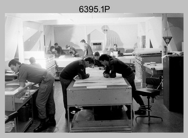
Photograph - Army Survey Regiment – Map Production, Fortuna, Bendigo, 1986
These 17 photographs of the Army Survey Regiment’s map production and facilities were taken at Fortuna Villa, Bendigo, April 1986. Photos .1P to .3P were taken in Cartographic Squadron’s Correcting Section in the Attic. located on the top floor of Fortuna Photos .4P to .5P were taken in Cartographic Squadron’s Proving Section, located in the Ballroom also on the top floor facing the lake. The technicians were probably involved in a rapid response map production, as they all were wearing field uniforms. As ‘Regiment Overcrowding’ is annotated on the plastic sleeve holding the negatives, it seems the photos were taken when the unit was at its capacity to demonstrate the lack of suitable work areas. The Army Survey Regiment’s Duty Room, RAP and Carpark appearing in Photo .10P was probably taken from the top steps near the SGT’s accommodation block. Two of the photos in this set are also published in item 6096.5P.This is a set of 17 photograph of Map Production and car park was taken at the Army Survey Regiment, Fortuna, Bendigo, in April 1986. The black & white photographs are on 35mm negative film and are part of the Army Survey Regiment’s Collection. The photographs were scanned at 96 dpi. .1) - Photo, black & white, 1986. Correcting Section, Attic: L to R: CPL Andy Lucas, SPR Chris Gordon, unidentified, SPR Jan (Crighton) Minchin, CPL Robin Marshall, CPL Frank Downie, SPR Gayle Humphrey, unidentified (x2), Jason Wells at rear. .2) - Photo, black & white, 1986. Correcting Section, Attic: L to R: CPL Andy Lucas, SPR Chris Gordon, unidentified, SPR Jan (Crighton) Minchin, CPL Robin Marshall, CPL Frank Downie, SPR Gayle Humphrey, unidentified, Jason Wells, unidentified. .3) - Photo, black & white, 1986. Correcting Section, Attic: L to R: CPL Andy Lucas, CPL Robin Marshall, SPR Chris Gordon, unidentified, CPL Frank Downie, SPR Gayle Humphrey, unidentified, SPR Jan (Crighton) Minchin at rear., Jason Wells on phone. .4) & .5) - Photo, black & white, 1986. Proving Section, Ballroom: On left front to back: SGT Alan Staley, SGT Roger Rees, SGT Greg Anderson. On right front to back: SGT Denis McCarthy, SGT Tim Allanson, SSGT Adrian ‘Charlie’ Creedy. .6) - Photo, black & white, 1986. Records & Proofing buildings. .7) - Photo, black & white, 1986. Technical Services temporary buildings. .8) - Photo, black & white, 1986. Q-store and transport buildings. .9) - Photo, black & white, 1986. Technical Services temporary buildings in front of transport compound. .10) - Photo, black & white, 1986. Army Survey Regiment Duty Room, RAP and Carpark at Fortuna. .11) - Photo, black & white, 1986. Records & Proofing buildings. .12) - Photo, black & white, 1986. Other Ranks (OR’s) car park and barracks with kitchen in background. .13) - Photo, black & white, 1986. Other Ranks kitchen, parade ground and SGT’s/Officers barracks in background. .14) - Photo, black & white, 1986. Fortuna Villa taken from the steps near the SGT’s accommodation block. .15) - Photo, black & white, 1986. Fortuna Villa taken from the steps near the OR’s s accommodation block. .16) - Photo, black & white, 1986. Fortuna Villa taken from the roadway near the OR’s accommodation block. .17) - Photo, black & white, 1986. 20’ x 30’ Army tents set up on the basketball court..1P to .17P – ‘Regiment Overcrowding’ and the date are annotated on the plastic sleeve.royal australian survey corps, rasvy, army survey regiment, army svy regt, fortuna, asr -
 Ballarat Tramway Museum
Map, H.P. James, Ballarat tramway system, 1939
Hand drawn map contained within Reg. Item 2488, page 61 of the Ballarat Tramway system. Note does not show the Drummond St. North line. Shows the loops, horse tram loops, depots, ESCo bus routes, and notes on horse tram loops. Prepared by H.P. James Scan btm2515i2 and 2515i3 show the hand written notes in light pencil. Note Item Not formally Numbered.trams, tramways, map, depot, esco, horse trams, bus routes, ballarat -
 Greensborough Historical Society
Map, Melbourne and Metropolitan Board of Works. Survey Division, MMBW, Yarra 2500 / 13.21. Central Greensborough, 1979_05
Melbourne and Metropolitan Board of Works. Yarra 2500 [base map]. 13-21, Parishes of Keelbundora 2856 and Nillumbik 3310, Municipality of Diamond Valley 257. Shows street names, easement sizes, lot numbers, lodged plan numbers, names of prominent features, contour values, creek or river names. Central Greensborough. Prominent streets: Main Street, Para Road, St Helena Road and Diamond Creek Road.MMBW Map in 1:2500 [scale] series. Cream parchment with green tape reinforcing on edges and punched holes on left edge.mmbw, melbourne and metropolitan board of works, shire of diamond valley, greensborough - maps -
 Greensborough Historical Society
Map, Melbourne and Metropolitan Board of Works. Survey Division, MMBW, Yarra 2500 / 12.19. Watsonia, Simpson Army Barracks, 1983_03
Melbourne and Metropolitan Board of Works. Yarra 2500 [base map]. 12-19, Parish of Keelbundora 2856, Municipalities of Diamond Valley 257 and 228. Shows street names, easement sizes, lot numbers, lodged plan numbers, names of prominent features, contour values, creek or river names. Watsonia Barracks (Simpson Army Barracks) and environs. Prominent streets: Yallambie Road, Greensborough Road, and Strathallan Road. MMBW Map in 1:2500 [scale] series. Cream parchment with green tape reinforcing on edges and punched holes on left edge.mmbw, melbourne and metropolitan board of works, shire of diamond valley, watsonia - maps -
 Greensborough Historical Society
Map, Melbourne and Metropolitan Board of Works. Survey Division, MMBW, Yarra 2500 / 13.22. Greensborough, Apollo Parkways, 1979_06
Melbourne and Metropolitan Board of Works. Yarra 2500 [base map] 13-22. Greensborough, Apollo Parkways. Parishes of Nillumbik 3310 and Keelbundora 2856. Municipalities of Diamond Valley 257 and Whittlesea 239. Prominent streets include: Plenty River Drive, Diamond Creek Road and Civic Drive. Includes Diamond Valley Civi Centre, Churinga, Janefield Colony Reserve and "proposed freeway" now Greensborough Highway (Bypass)MMBW Map in 1:2500 [scale] series. Cream parchment with green tape reinforcing on edges and punched holes on left edge.mmbw, melbourne and metropolitan board of works, shire of diamond valley, greensborough - maps, apollo parkways - maps -
 4th/19th Prince of Wales's Light Horse Regiment Unit History Room
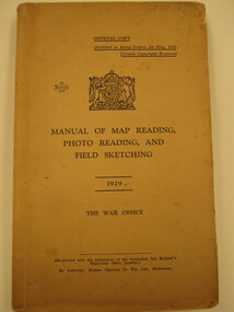
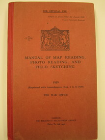
Book, Modern Printing Co Pty Ltd, Manual of Map Reading, Photo Reading and Field Sketching1929, abt 1929
Soft covered book covering map reading, field sketching and air photo reading for use of Officer candidates, Officers and NCO's. Reprinted with amendments Nos 1 - 4, 1939. 2 copies26 manuals 412manual, map reading, air photo reading, field sketching -
 4th/19th Prince of Wales's Light Horse Regiment Unit History Room
Book, Manual of Map Reading, Photo Reading and Field Sketching1929, abt 1940
Hard covered book covering map reading, field sketching and air photo reading for use of Officer candidates, Officers and Non-commissioned Officers. Reprinted with amdts Nos 1 - 4 193926 Manuals 412manual, map reading, air photo interpretation, field sketching -
 Federation University Historical Collection
Map, Central Ballarat Retail and Business Guide, 2004, 11/2004
Map of the Ballarat Central area, and business guide.ballarat central, brown hill, ballarat east -
 Federation University Historical Collection
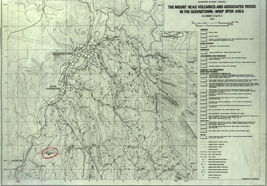
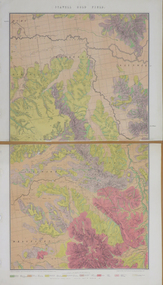
Map, The Mount Read Volcanics and Associated Rocks in the Queenstown - Whip Spur Area, 1978, 1978
Contour map of the Queenstown area in Tasmania, Australia.department of mines tasmania, volcanics, mount read, queesntown, whip spur, mining, king river, gormanston, mt owen, lynchford -
 Federation University Historical Collection
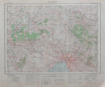
Map, Melbourne, 1943, 1943
2 copies of printed colour map on papermelbourne -
Clunes Museum
Map, Oct-74
MAP OF CLUNES STREETS/TOWNSHIP - SCALE IN CHAINSlocal history, document, maps, maps -
Whitehorse Historical Society Inc.
Map, Community facilities, 1/10/1981 12:00:00 AM
Map of the City of Nunawading showing community facilitiesMap of the City of Nunawading showing community facilitiesMap of the City of Nunawading showing community facilitiesparks and reserves, city of nunawading, schools, senior citizens centres, maternal and child health centres, post offices, police stations, preschools -
Whitehorse Historical Society Inc.
Map, Eastern Freeway, n.d
Map of proposed Eastern Freeway, Mitcham - Ringwood.Map of proposed Eastern Freeway, Mitcham - Ringwood.Map of proposed Eastern Freeway, Mitcham - Ringwood.freeways, eastern freeway, mullum mullum creek -
 Whitehorse Historical Society Inc.
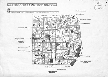
Map, Nunawading parks and recreation information, 1990 ?
Map of parks and reserves in the City of Nunawading, 199-?city of nunawading. parks and recreation department, parks and reserves -
 Ballarat Heritage Services
Map, Central Europe and the Mediterranean during World War One
Map of the World as it was during World War One. map of the world, world war one, france, spain, england, ireland, germany, austria-hungary, rumania, servia, albania, greece, bulgaria, russia, asia minor, turkey, egypt, tripoli, morocco, algeria, tunis -
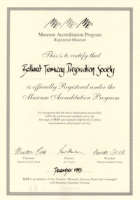 Ballarat Tramway Museum
Certificate - Framed certificate, Museums Australia, BTPS Museum Registration MAP 1993, Dec. 1993
Framed certificate for the Registration of the Ballarat Tramway Preservation Society under the Museum Accreditation Programme, dated Dec. 1993. The certificate signed by Weston Bate (Chairman Museums Advisory Board), Paul Clarkson (Director Arts Victoria), Annette Shiell (President Museums Association). Framed with a metal glazed frame, with two sheets of heavy cardboard and heavy black card with cut outs for hanging or standing. Certificate printed on heavy cartridge paper.trams, tramways, museum accreditation, museum, btps, map -
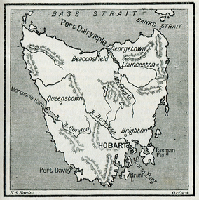 Ballarat Heritage Services
Photograph - Map, Hobart and Port Dalrymple
Copy of a map from 'A Short History of Australia' by Ernest Scott.map, explorers, exploration, bass straight, hobart, port davey, georgetown, beaconsfield, queenstown, gordon rover, derwent river, launceston, port dalrymple, banks straight, macquarie harbour, maps, plans -
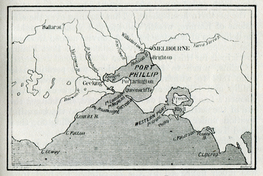 Ballarat Heritage Services
Map, Westernport and Port Phillip
Copy of a map from 'A Short History of Australia' by Ernest Scott.map, explorers, exploration, westernport, port phillip, queenscliffe, melbourne, brighton, williamstown, port arlington, hobson bay, cape otway, geelong, barwon river, ballarat, yarra river, yarra yarra river -
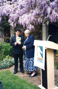 Whitehorse Historical Society Inc.
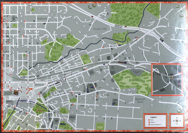
Photograph, Launch of Valley of the Arts Tourist Map, 1/10/2000 12:00:00 AM
Coloured photo of Minister for Tourism, John Pandazopoulos and Mayor of City of Whitehorse, Cr, Jessie MacCallum at launch of Co-operative venture Valley of the Arts Tourist Map at Schwerkolt Cottage on 6th October 2000.pandazopoulos, john, maccallum. jessie, city of whitehorse, valley of the arts, schwerkolt cottage. -
 4th/19th Prince of Wales's Light Horse Regiment Unit History Room
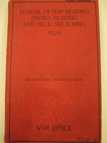
Book, Manual of Map Reading, Photo Reading and Field Sketching 1929, 1948
Hard cardboard covered book, covering map reading, field sketching and air photo reading for use of officer candidates, officers and non-commissioned officers. Reprinted with amendments Nos 1 -4, 193926 GS Pubns 124manual, map reading, air photo interpretation, field sketching -
 Ringwood and District Historical Society
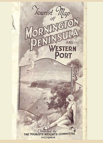
Memorabilia, Tourist Map of Mornington Peninsula and Western Port - 1929
Multi-fold pictorial map of towns, railways and main roads east of Port Phillip Bay from Melbourne to Yarra Junction and south to Phillip Island and Wonthaggi, backed by details of main features and points of interest.Photo-Lithographed by Department of Lands and Survey, Melbourne, 2.8.1929. -
 Greensborough Historical Society
Map, Melbourne and Metropolitan Board of Works. Survey Division, MMBW, Yarra 2500 / 12.20. Watsonia Railway Station and environs, 1983_03
Melbourne and Metropolitan Board of Works. Yarra 2500 [base map]. 12-20, Parishes of Keelbundora 2856, Municipalities of Diamond Valley 257 and 228. Shows street names, easement sizes, lot numbers, lodged plan numbers, names of prominent features, contour values, creek or river names. Watsonia Railway Station and environs. Prominent streets: Watsonia Road, Elder Street, Morwell Avenue and Nepean Street. Includes former Watsonia Technical School and Gresswell Rehabilitation Centre sites.MMBW Map in 1:2500 [scale] series. Cream parchment with green tape reinforcing on edges and punched holes on left edge.mmbw, melbourne and metropolitan board of works, shire of diamond valley, watsonia - maps -
 Greensborough Historical Society
Map, Melbourne and Metropolitan Board of Works. Survey Division, MMBW, Yarra 2500 / 12.21. Watsonia North, 1979_02
Melbourne and Metropolitan Board of Works. Yarra 2500 [base map]. 12-22, Parish of Keelbundora 2856, Municipality of Diamond Valley 257. Shows street names, easement sizes, lot numbers, lodged plan numbers, names of prominent features, contour values, creek or river names. Watsonia Railway Station and environs. Prominent streets: Grimshaw Street, William Street and Macorna Street. Includes former Institute of Social Welfare (now Loyola College) Lines Reserve and Binnak Park.MMBW Map in 1:2500 [scale] series. Cream parchment with green tape reinforcing on edges and punched holes on left edge.mmbw, melbourne and metropolitan board of works, shire of diamond valley, watsonia - maps, bundoora - maps -
 Federation University Historical Collection
Map, Stawell, Victoria, 1878
Printed colour map on paper, edged in masking tape stawell, e.r. morris, william collard smith -
 Federation University Historical Collection
Map, Sorrento, 1931, 03/1931
Printed colour map on paper showing Sorrento and surroundssorrento, point nepean, point lonsdale, queenscliff, port phillip bay -
Whitehorse Historical Society Inc.
Map, Nunawading - Bromide
Map of the City of Nunawading indicating suburbs - marked 'Bromide'Map of the City of Nunawading indicating suburbs - marked 'Bromide'Map of the City of Nunawading indicating suburbs - marked 'Bromide'maps, city of nunawading -
Whitehorse Historical Society Inc.
Map, Council facilities, c1992
Map of City of Nunawading with parks and facilities marked and indexed.Map of City of Nunawading with parks and facilities marked and indexed.Map of City of Nunawading with parks and facilities marked and indexed.recreation facilities, city of nunawading, maternal and child health centres, senior citizens centres, parks and reserves, libraries, child care