Showing 2399 items matching " structure"
-
 Port Melbourne Historical & Preservation Society
Photograph - Magnolia, 75 Evans Street, Port Melbourne, Meredith Turnbull, Dec 1996
Meredith Turnbull photographed this series in 1996 to record the rapidly changing streetscape, which had already had a number of old houses replaced by concrete two-storey structures under the State government's urban consolidation policyFrom a series of 70 colour photos recording all buildings in Evans Street from Graham Street overpass to Ingles Street, as photographed from the railway reservation, by Meredith TURNBULL in December 1996 - number 75, 'Magnolia' (once home of Phillip SALMON) -House numbers noted on backbuilt environment - domestic, meredith turnbull, phillip melville salmon -
Port Melbourne Historical & Preservation Society
Photograph - Lily Cottage, 77 Evans Street, Port Melbourne, Meredith Turnbull, Dec 1996
Meredith Turnbull photographed this series in 1996 to record the rapidly changing streetscape, which had already had a number of old houses replaced by concrete two-storey structures under the State government's urban consolidation policyFrom a series of 70 colour photos recording all buildings in Evans Street from Graham Street overpass to Ingles Street, as photographed from the railway reservation, by Meredith Turnbull in December 1996 - two of number 77 (Lily Cottage)House numbers noted on backbuilt environment - domestic, meredith turnbull -
Port Melbourne Historical & Preservation Society
Photograph - 79 Evans Street, Port Melbourne, Meredith Turnbull, Dec 1996
Meredith Turnbull photographed this series in 1996 to record the rapidly changing streetscape, which had already had a number of old houses replaced by concrete two-storey structures under the State government's urban consolidation policyFrom a series of 70 colour photos recording all buildings in Evans Street from Graham Street overpass to Ingles Street, as photographed from the railway reservation, by Meredith Turnbull in December 1996 - number 79House numbers noted on backbuilt environment - domestic, meredith turnbull -
Port Melbourne Historical & Preservation Society
Photograph - 82 & 83 Evans Street, Port Melbourne, Meredith Turnbull, Dec 1996
Meredith Turnbull photographed this series in 1996 to record the rapidly changing streetscape, which had already had a number of old houses replaced by concrete two-storey structures under the State government's urban consolidation policyFrom a series of 70 colour photos recording all buildings in Evans Street from Graham Street overpass to Ingles Street, as photographed from the railway reservation, by Meredith Turnbull in December 1996 - number 82, 83House numbers noted on backbuilt environment - domestic, meredith turnbull -
Port Melbourne Historical & Preservation Society
Photograph - 85 & 86 Evans Street, Port Melbourne, Meredith Turnbull, Dec 1996
Meredith Turnbull photographed this series in 1996 to record the rapidly changing streetscape, which had already had a number of old houses replaced by concrete two-storey structures under the State government's urban consolidation policyFrom a series of 70 colour photos recording all buildings in Evans Street from Graham Street overpass to Ingles Street, as photographed from the railway reservation, by Meredith Turnbull in December 1996 - number 85, 86 (corner shop at Bridge Street)House numbers noted on backbuilt environment - domestic, meredith turnbull -
Port Melbourne Historical & Preservation Society
Photograph - Bridge Street, Port Melbourne, Meredith Turnbull, Dec 1996
Meredith Turnbull photographed this series in 1996 to record the rapidly changing streetscape, which had already had a number of old houses replaced by concrete two-storey structures under the State government's urban consolidation policyFrom a series of 70 colour photos recording all buildings in Evans Street from Graham Street overpass to Ingles Street, as photographed from the railway reservation, by Meredith Turnbull in December 1996 - Bridge StreetHouse numbers noted on backbuilt environment - domestic, meredith turnbull -
Port Melbourne Historical & Preservation Society
Photograph - 85 Evans Street, Port Melbourne, Meredith Turnbull, Dec 1996
Meredith Turnbull photographed this series in 1996 to record the rapidly changing streetscape, which had already had a number of old houses replaced by concrete two-storey structures under the State government's urban consolidation policyFrom a series of 70 colour photos recording all buildings in Evans Street from Graham Street overpass to Ingles Street, as photographed from the railway reservation, by Meredith Turnbull in December 1996 - number 85House numbers noted on backbuilt environment - domestic, meredith turnbull -
Port Melbourne Historical & Preservation Society
Photograph - 90 Evans Street, Port Melbourne, Meredith Turnbull, Dec 1996
Meredith Turnbull photographed this series in 1996 to record the rapidly changing streetscape, which had already had a number of old houses replaced by concrete two-storey structures under the State government's urban consolidation policyFrom a series of 70 colour photos recording all buildings in Evans Street from Graham Street overpass to Ingles Street, as photographed from the railway reservation, by Meredith Turnbull in December 1996 - number 90House numbers noted on backbuilt environment - domestic, meredith turnbull -
Port Melbourne Historical & Preservation Society
Photograph - 92 & 94 Evans Street, Port Melbourne, Meredith Turnbull, Dec 1996
Meredith Turnbull photographed this series in 1996 to record the rapidly changing streetscape, which had already had a number of old houses replaced by concrete two-storey structures under the State government's urban consolidation policyFrom a series of 70 colour photos recording all buildings in Evans Street from Graham Street overpass to Ingles Street, as photographed from the railway reservation, by Meredith Turnbull in December 1996 - number 92, 94House numbers noted on backbuilt environment - domestic, meredith turnbull -
Port Melbourne Historical & Preservation Society
Photograph - 96 Evans Street, Port Melbourne, Meredith Turnbull, Dec 1996
Meredith Turnbull photographed this series in 1996 to record the rapidly changing streetscape, which had already had a number of old houses replaced by concrete two-storey structures under the State government's urban consolidation policyFrom a series of 70 colour photos recording all buildings in Evans Street from Graham Street overpass to Ingles Street, as photographed from the railway reservation, by Meredith Turnbull in December 1996 - number 96House numbers noted on backbuilt environment - domestic, meredith turnbull -
Port Melbourne Historical & Preservation Society
Photograph - 98, 99 & 100 Evans Street, Port Melbourne, Meredith Turnbull, Dec 1996
Meredith Turnbull photographed this series in 1996 to record the rapidly changing streetscape, which had already had a number of old houses replaced by concrete two-storey structures under the State government's urban consolidation policyFrom a series of 70 colour photos recording all buildings in Evans Street from Graham Street overpass to Ingles Street, as photographed from the railway reservation, by Meredith Turnbull in December 1996 - number 98, 99, 100House numbers noted on backbuilt environment - domestic, meredith turnbull -
Port Melbourne Historical & Preservation Society
Photograph - 102, 104 & 106 Evans Street, Port Melbourne, Meredith Turnbull, Dec 1996
Meredith Turnbull photographed this series in 1996 to record the rapidly changing streetscape, which had already had a number of old houses replaced by concrete two-storey structures under the State government's urban consolidation policyFrom a series of 70 colour photos recording all buildings in Evans Street from Graham Street overpass to Ingles Street, as photographed from the railway reservation, by Meredith Turnbull in December 1996 - number 102, 104, 106House numbers noted on backbuilt environment - domestic, meredith turnbull -
Port Melbourne Historical & Preservation Society
Photograph - 106, 108 & 110 Evans Street, Port Melbourne, Meredith Turnbull, Dec 1996
Meredith Turnbull photographed this series in 1996 to record the rapidly changing streetscape, which had already had a number of old houses replaced by concrete two-storey structures under the State government's urban consolidation policyFrom a series of 70 colour photos recording all buildings in Evans Street from Graham Street overpass to Ingles Street, as photographed from the railway reservation, by Meredith Turnbull in December 1996 - numbers 106, 108, 100House numbers noted on backbuilt environment - domestic, meredith turnbull -
Port Melbourne Historical & Preservation Society
Photograph - 114 & 115 Evans Street, Port Melbourne, Meredith Turnbull, Dec 1996
Meredith Turnbull photographed this series in 1996 to record the rapidly changing streetscape, which had already had a number of old houses replaced by concrete two-storey structures under the State government's urban consolidation policyFrom a series of 70 colour photos recording all buildings in Evans Street from Graham Street overpass to Ingles Street, as photographed from the railway reservation, by Meredith Turnbull in December 1996 - number 114, 115House numbers noted on backbuilt environment - domestic, meredith turnbull -
Port Melbourne Historical & Preservation Society
Photograph - 118 Evans Street, Port Melbourne, Meredith Turnbull, Dec 1996
Meredith Turnbull photographed this series in 1996 to record the rapidly changing streetscape, which had already had a number of old houses replaced by concrete two-storey structures under the State government's urban consolidation policyFrom a series of 70 colour photos recording all buildings in Evans Street from Graham Street overpass to Ingles Street, as photographed from the railway reservation, by Meredith Turnbull in December 1996 - number 118House numbers noted on backbuilt environment - domestic, meredith turnbull -
Port Melbourne Historical & Preservation Society
Photograph - 123 & 124 Evans Street, Port Melbourne, Meredith Turnbull, Dec 1996
Meredith Turnbull photographed this series in 1996 to record the rapidly changing streetscape, which had already had a number of old houses replaced by concrete two-storey structures under the State government's urban consolidation policyFrom a series of 70 colour photos recording all buildings in Evans Street from Graham Street overpass to Ingles Street, as photographed from the railway reservation, by Meredith Turnbull in December 1996 - number 123, 124House numbers noted on backbuilt environment - domestic, meredith turnbull -
Port Melbourne Historical & Preservation Society
Photograph - 125, 126, 127 & 128 Evans Street, Port Melbourne, Meredith Turnbull, Dec 1996
Meredith Turnbull photographed this series in 1996 to record the rapidly changing streetscape, which had already had a number of old houses replaced by concrete two-storey structures under the State government's urban consolidation policyFrom a series of 70 colour photos recording all buildings in Evans Street from Graham Street overpass to Ingles Street, as photographed from the railway reservation, by Meredith Turnbull in December 1996 - number 125, 126, 127, 128House numbers noted on backbuilt environment - domestic, meredith turnbull -
Port Melbourne Historical & Preservation Society
Photograph - 129, 130 & 132 Evans Street, Port Melbourne, Meredith Turnbull, Dec 1996
Meredith Turnbull photographed this series in 1996 to record the rapidly changing streetscape, which had already had a number of old houses replaced by concrete two-storey structures under the State government's urban consolidation policyFrom a series of 70 colour photos recording all buildings in Evans Street from Graham Street overpass to Ingles Street, as photographed from the railway reservation, by Meredith Turnbull in December 1996 - number 129, 130, 132House numbers noted on backbuilt environment - domestic, meredith turnbull -
Port Melbourne Historical & Preservation Society
Photograph - 135 & 137 Evans Street (Raglan Street Housing Commission flats), Port Melbourne, Meredith Turnbull, Dec 1996
Meredith Turnbull photographed this series in 1996 to record the rapidly changing streetscape, which had already had a number of old houses replaced by concrete two-storey structures under the State government's urban consolidation policyFrom a series of 70 colour photos recording all buildings in Evans Street from Graham Street overpass to Ingles Street, as photographed from the railway reservation, by Meredith Turnbull in December 1996 - - number 135, 137- Raglan Street Housing Commission flatsHouse numbers noted on backbuilt environment - domestic, built environment - public housing, meredith turnbull -
Port Melbourne Historical & Preservation Society
Photograph - 141 Evans Street (Raglan Street Housing Commission flats), Port Melbourne, Meredith Turnbull, Dec 1996
Meredith Turnbull photographed this series in 1996 to record the rapidly changing streetscape, which had already had a number of old houses replaced by concrete two-storey structures under the State government's urban consolidation policyFrom a series of 70 colour photos recording all buildings in Evans Street from Graham Street overpass to Ingles Street, as photographed from the railway reservation, by Meredith Turnbull in December 1996 - number 141 - Raglan Street Housing Commission flatsHouse numbers noted on backbuilt environment - domestic, built environment - public housing, meredith turnbull -
Port Melbourne Historical & Preservation Society
Photograph - 148, 150 & 151 Evans Street, Port Melbourne, Meredith Turnbull, Dec 1996
Meredith Turnbull photographed this series in 1996 to record the rapidly changing streetscape, which had already had a number of old houses replaced by concrete two-storey structures under the State government's urban consolidation policyFrom a series of 70 colour photos recording all buildings in Evans Street from Graham Street overpass to Ingles Street, as photographed from the railway reservation, by Meredith Turnbull in December 1996 - number 148, 150, 151House numbers noted on backbuilt environment - domestic, meredith turnbull -
Port Melbourne Historical & Preservation Society
Photograph - 151, 152, 153 & 154 Evans Street, Port Melbourne, Meredith Turnbull, Dec 1996
Meredith Turnbull photographed this series in 1996 to record the rapidly changing streetscape, which had already had a number of old houses replaced by concrete two-storey structures under the State government's urban consolidation policyFrom a series of 70 colour photos recording all buildings in Evans Street from Graham Street overpass to Ingles Street, as photographed from the railway reservation, by Meredith Turnbull in December 1996 - number 151, 152, 153, 154House numbers noted on backbuilt environment - domestic, meredith turnbull -
Port Melbourne Historical & Preservation Society
Photograph - 154, 156 & 157 Evans Street, Port Melbourne, Meredith Turnbull, Dec 1996
Meredith Turnbull photographed this series in 1996 to record the rapidly changing streetscape, which had already had a number of old houses replaced by concrete two-storey structures under the State government's urban consolidation policyFrom a series of 70 colour photos recording all buildings in Evans Street from Graham Street overpass to Ingles Street, as photographed from the railway reservation, by Meredith Turnbull in December 1996 - number 154, 156, 157House numbers noted on backbuilt environment - domestic, meredith turnbull -
Port Melbourne Historical & Preservation Society
Photograph - 157, 159 & 160 Evans Street, Port Melbourne, Meredith Turnbull, Dec 1996
Meredith Turnbull photographed this series in 1996 to record the rapidly changing streetscape, which had already had a number of old houses replaced by concrete two-storey structures under the State government's urban consolidation policyFrom a series of 70 colour photos recording all buildings in Evans Street from Graham Street overpass to Ingles Street, as photographed from the railway reservation, by Meredith Turnbull in December 1996 - 157, 159, 160House numbers noted on backbuilt environment - domestic, meredith turnbull -
Port Melbourne Historical & Preservation Society
Photograph - 161 & 162 Evans Street, Port Melbourne, Meredith Turnbull, Dec 1996
Meredith Turnbull photographed this series in 1996 to record the rapidly changing streetscape, which had already had a number of old houses replaced by concrete two-storey structures under the State government's urban consolidation policyFrom a series of 70 colour photos recording all buildings in Evans Street from Graham Street overpass to Ingles Street, as photographed from the railway reservation, by Meredith Turnbull in December 1996 - number 161, 162House numbers noted on backbuilt environment - domestic, meredith turnbull -
Port Melbourne Historical & Preservation Society
Photograph - 163, 164, 165 & 166 Evans Street, Port Melbourne, Meredith Turnbull, Dec 1996
Meredith Turnbull photographed this series in 1996 to record the rapidly changing streetscape, which had already had a number of old houses replaced by concrete two-storey structures under the State government's urban consolidation policyFrom a series of 70 colour photos recording all buildings in Evans Street from Graham Street overpass to Ingles Street, as photographed from the railway reservation, by Meredith Turnbull in December 1996 - number 163 (obscured), 164, 165, 166House numbers noted on backbuilt environment - domestic, meredith turnbull -
Port Melbourne Historical & Preservation Society
Photograph - 169 Evans Street, Port Melbourne, Meredith Turnbull, Dec 1996
Meredith Turnbull photographed this series in 1996 to record the rapidly changing streetscape, which had already had a number of old houses replaced by concrete two-storey structures under the State government's urban consolidation policyFrom a series of 70 colour photos recording all buildings in Evans Street from Graham Street overpass to Ingles Street, as photographed from the railway reservation, by Meredith Turnbull in December 1996 - number 169House numbers noted on backbuilt environment - domestic, meredith turnbull -
Creswick Campus Historical Collection - University of Melbourne
Equipment, Forests Commission of NSW, A Card Key to Pinus Based on Needle Anatomy, 1966
Card sorting key for Pinus. Seried of punched cards. Cell structure diagrams on rear. Plant characteristics on face. Complete set with instruction booklet boxed in a red case. Produced by FC NSW, Joyce W. LanyonEquipmentJohn Mcdonald -
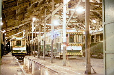 Ballarat Tramway Museum
Photograph - Digital Image, Peter Knife, Night scene - tram depot Wendouree Parade, 31/3/1971
Digital image of the SEC Depot Wendouree Parade at night with trams 27, 18 and 34 inside the depot. Shows the depot roof structure as well as some of the interior features. Photo by Peter Knife 31/3/1971.Yields information about the interior of the SEC tram depot.Digital image of a colour slide.tramways, tramcars, ballarat, depot, tram 27, tram 18, tram 34 -
Port Melbourne Historical & Preservation Society
Photograph - Albion Hotel, Evans Street, Port Melbourne, Meredith Turnbull, Dec 1996
Meredith TURNBULL photographed this series in 1996 to record the rapidly changing streetscape, which had already had a number of old houses replaced by concrete two-storey structures under the State government's urban consolidation policyFrom a series of 70 colour photos recording all buildings in Evans Street from Graham Street overpass to Ingles Street, as photographed from the railway reservation, by Meredith TURNBULL in December 1996 - Raglan Street and Albion HotelHouse numbers noted on backbuilt environment - domestic, built environment - commercial, business and traders - hotels, meredith turnbull, albion hotel