Showing 2472 items matching " township"
-
 Merbein District Historical Society
Administrative Record, Ledger, Irrigation Rate Book - Merbein (Parish), 1917-1920
township, state rivers and water supply commission -
Merbein District Historical Society
Administrative Record, Ledger, Irrigation Rate Book - Merbein (Parish), 1935-1938
township, state rivers and water supply commission -
 Lakes Entrance Historical Society
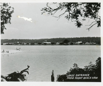
Postcard, 1945c
Black and white small format postcard showing a distant view of the town, taken from the southern shore of the lake. The view shows a glimpse of the beach known formerly as Play Point, the picture framed by native vegetation. Lakes Entrance VictoriaLakes Entrance from front beach armtownship, waterfront -
 Lakes Entrance Historical Society
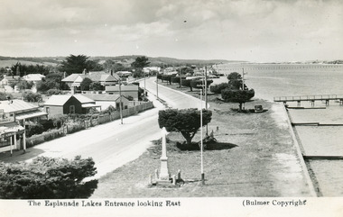
Postcard - Esplanade Lakes Entrance
Black and white postcard showing Esplanade, cenotaph Lakes Entrance VictoriaView from lookout tower Lakes Entranceroads and streets, township -
 Lakes Entrance Historical Society
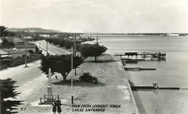
Postcard - Esplanade Lakes Entrance
Black and white postcard showing Esplanade, cenotaph Lakes Entrance VictoriaView from lookout tower Lakes Entranceroads and streets, township -
Lakes Entrance Historical Society
Book, Hansen Neil, Paynesville a very Special Place, 1981
A pictorial history of Paynesville Victoriatownship, local history -
Lakes Entrance Historical Society
Book, Beesley Midge, Raymond Island Past Present Future, 1986
An account of the history and development of Raymond Island Victoria including early settlers and present occupiers of this unique part of the Gippsland lakes. Indexedtownship, settlers -
 Lakes Entrance Historical Society
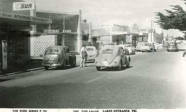
Postcard - National Bank, The Rose Series, 1955c
Black and white postcard of portion of Esplanade, showing petrol bowser, Newsagency, National Bank, a cafe advertising Sennitts Ice Cream, Central Hotel in distance. Also cars on roadway. Lakes Entrance VictoriaThe Esplanade, Lakes Entrance, Victownship, retail trade -
 Lakes Entrance Historical Society
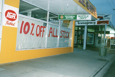
Photograph - Arceris Supermarket, 1995
Date made 11 May 1995.Colour photograph of the front windows of Arceris Supermarket, fronting Esplanade, soon after closing down after almost twenty years trading. Shows windows of bottle shop covered in white paper. Also in view Lakes Entrance Newsagency, National Bank and telephone box. Lakes Entrance Victoriaretail trade, township -
 Lakes Entrance Historical Society
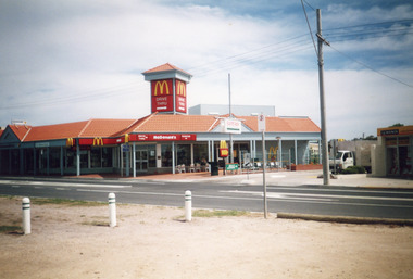
Photograph - MacDonalds Restaurant, Bennett, Vera, 2003c
The McDonalds store was opened on 19 December 1987Colour photograph of McDonald's restaurant, Esplanade. A small truck on laneway between McDonald's and Hookers Estate Agent. In foreground three bollards to limit parking on verge between Princes Highway and lake. Building of shops behind McDonald's being commenced. Lakes Entrance Victoriatownship, restaurant -
Clunes Museum
Photograph
BLACK AND WHITE PHOTOGRAPH LOOKING SOUTH OVER CLUNESOn Reverse; Must have been taken before 1872clunes, township -
Lakes Entrance Historical Society
Book, Porter, Hal, Bairnsdale' Portrait of an Australian Country Town, 1977
An affectionate portrait of the town of Bairnsdale, East Gippsland, Victoria, and its people.explorers, township -
Lakes Entrance Historical Society
Book, Green Daniel, Lakes Entrance During World War Two, 1989
Students essays written after interviewing three residents who spoke of the effect of the second world war on lakes Entrance Victoriaworld war 1939 - 1945, township -
Lakes Entrance Historical Society
Book, Ferguson B J, A Sort History Merimbula, 1976
A brief overview of historical events which shaped Merimbula New South Walesaboriginals, township -
Lakes Entrance Historical Society
Book, Howe, K.R, Mallacoota Reflections, 1990
A short history of Mallacoota, Victoria, and district, covering a range of subjects from Aboriginal occupation to late 20th.Century residents and lifestyle.township, aboriginals -
 Lakes Entrance Historical Society
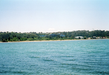
Photograph - Kalimna, Davies, Judy, 2005c
Colour photograph of a distant view of Kalimna Heights and the western end, across the waters of Cunninghame Arm. Shows the recently constructed tourist complex behind the Club Spit and other buildings on Esplanade. Lakes Entrance Victoriawaterways, township -
Lakes Entrance Historical Society
Book, City of Bairnsdale
Glossy pamphlet with photographs giving brief information on the history, industries and lifestyle in the city of Bairnsdale, Victoria.township, industrial -
Lakes Entrance Historical Society
Book, Davidson Jan and Smith Heather, Bairnsdale the way we were, 1984
Pictorial history of Bairnsdales beautiful buildings, presented as pen and ink drawings accompanied by description text.township, buildings -
Lakes Entrance Historical Society
Book, Barraclough, Linda - Compiler, Bairnsdale Looking Back, 1982
Descriptions of early buildings and locations in Bairnsdale, Victoria, accompanied by historic photographs.Ruth Clarktownship, buildings -
Lakes Entrance Historical Society
Book, Butlers Wood's Point and Gippsland General Directory, 1985
Facsimile edition of Butlers Gippsland Directory of 1866. Includes businesses, banks, postal officers, churches, and general information on all settlements of the time.directories, township -
Lakes Entrance Historical Society
Book, Black, Bill and Rash, Esme, Report, Burra Charter, 2007
Report, using guidelines as outlined in the Burra Charter, on the building on the northern end of the Port Albert wharf, currently used by Port Albert Seafoods. The building is due for demolition in April, 2007.township, waterways -
Lakes Entrance Historical Society
Book, Clark, Vincent and Anderson Tsari, Ocean Access Boat Ramp Bastion Point Mallacoota, 2005
Cultural Heritage Investigation. Report to East Gippsland Shire Council. Cultural Heritage Investigation.waterways, township -
Lakes Entrance Historical Society
Book, Hitchings Bill, Grand Dreams and Grand Men- Manchester Unity, 1988
A chronicle of the Manchester Unity Building Melbourne from its inception, through its controversial and innovative construction to its eventual change of ownership. The life of Melbourne from the depression years to the 1980's is reflected in the accountarchitecture, township -
 Lakes Entrance Historical Society
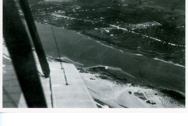
Photograph - Lakes Entrance, Bulmer H D, Whiters Camp Park, 1940c
Black and white copy photograph of aerial view of eastern approach, showing Princes Highway, Whiter's Camp Park, sandy outer barrier beside Cunninghame Arm, distant view of North Arm. Lakes Entrance Victoriawaterways, township -
Lakes Entrance Historical Society
Book, Boddy Doris M, Beyond the Ninety Mile
The early happenings of Woodside Bruthen Creek Snugborough Mullundung Cherry Tree Flat and Balloong in South Gippsland Victoria collected from local families and named sources.township, settlers -
 Lakes Entrance Historical Society
Postcard - North Arm bridge Lakes Entrance Victoria, Bulmer H D, 1950c
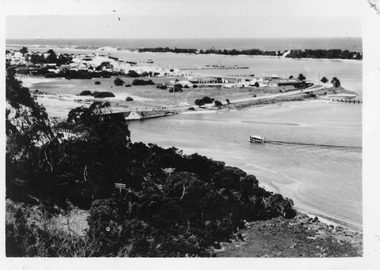
3 Identical small format postcards 9 x 14Black and white small format postcard showing the town, North Arm bridge, Cunninghame Arm, sand hummocks, boat harbour, tourist launch approaching North Arm, power poles on lower side of road cutting. Lakes Entrance VictoriaLakes Entrance from Jemmys Pointbridges, township -
 Lakes Entrance Historical Society
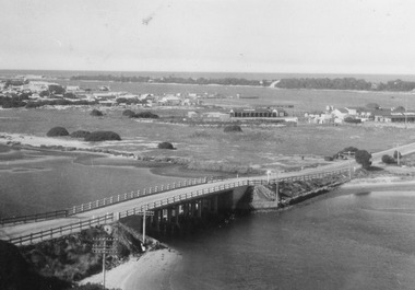
Photograph - Aerial view of North Arm Bridge, 1930c
Black and white photograph concrete bridge over North Arm, two people at southern end of bridge, swampy area approaching Club Hotel. Lakes Entrance Victoriabridges, township -
 Lakes Entrance Historical Society
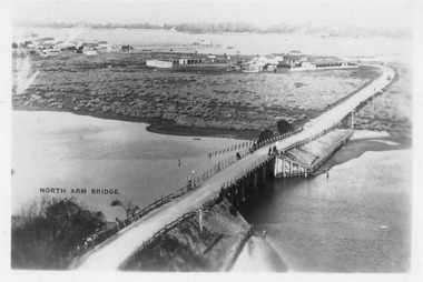
Postcard - North Arm bridge Lakes Entrance Victoria, Bulmer, H D, 1940c
Black and white postcard of bridge across North Arm, showing post and rail fences on abutments; low tide in North Arm; town buildings and Club Hotel, Cunninghame Arm and sand hummocks with ocean in far distance. Lakes Entrance Victoriabridges, township -
Lakes Entrance Historical Society
Book, Gardner P D, Names of the Great Alpine Road between Wangaratta and Omeo, 1998
Some of the place names appearing on the road between Wangaratta and Omeo, and explanations of their meanings. Illustrated with photographs, drawings and maps.township, social history -
Lakes Entrance Historical Society
Book, Rob Christie, Cargo Crooked River 1984 edition, 2000
This updated edition gives a broader picture of life on the Dargo Crooked River goldfields, Illustrated with photographs and maps.mines and mining, township