Showing 3425 items
matching distance
-
 Lakes Entrance Historical Society
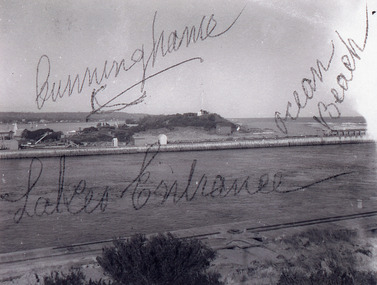
Photograph - New Works, 1920c
Black and white photograph showing entrance view from western pier towards eastern pier and works buildings, includes flagstaff rocket shed, township in distance, tramline along western pier in foreground, at Lakes Entrance, Victoria.Cunninghame Ocean Beachwaterways, piers, historic buildings -
 Lakes Entrance Historical Society
Photograph - Post Office, 1923c
Freeman's took over the store after the death of John Barke, December 1921, photo taken before the removal of native trees and planting of Memorial Cypresses in 1924Black and white photograph of Esplanade, showing Freemans, previously Barkes Store, the Post Office, and Postmasters residence, with other buildings in the distance. Two tall trees between road and bluestone wall on the edge of the lake. Lakes Entrance Victoriatownship, waterfront, postal services -
 Lakes Entrance Historical Society
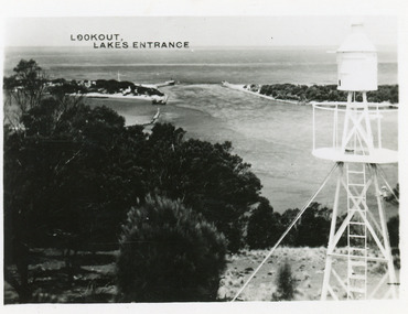
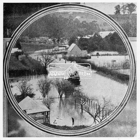
Photograph - The Entrance, 1950c
Also postcard 7 x 10.5, similar image,Black and white photograph of the entrance, taken from lookout on Jemmys Point, shows signal light adjacent to lookout, people on slope in front of signal, New Works cottages on hummocks, ocean horizon in distance. Lakes Entrance VictoriaThe Entrance from Jemmy's Pointwaterways, ocean, navigation -
 Queenscliffe Maritime Museum
Equipment - Ships Log Measuring Rotator
Used by all ships until replaced by more modern methods after c.1960. Used with clock recorder, log line and governor to record distance travelled.Ships log rotator and connecting eyeInsignia, T W Cherub 245, T Walker and Son Ltd. Birmingham Englandships measuring log -
 Melbourne Tram Museum
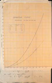
Drawing - Braking Curve, Melbourne & Metropolitan Tramways Board (MMTB), c1920
Set of two documents: 1 - Braking chart for a retardation or deceleration of 4 ft/sec/sec - for miles per hour and distance in feet. 2 - calculations for above.Yields information about braking distances for various speeds.Set of two documents - on quarto graph paper and hand written foolscap sheet.trams, tramways, brakes, braking -
 Bendigo Military Museum
Photograph - RA Svy Project C4 Aerodist Operation, Eastern Arnhem Land, NT, 1967
This is a set of 30 photographs of Royal Australian Survey Corps (RA Svy) personnel from Central Comd Fd Svy Unit (Adelaide) on Aerodist survey operation - Project C4 in Eastern Arnhem Land, Northern Territory in 1967. Photos of personnel were taken either at the operations base at Numbulwar or the main base at Gove (Nhulunbuy). RA Svy conducted nineteen Aerodist operations for 12 years from 1964 to 1975. Aerodist MRC2 was a tellurometer-based system adapted for aircraft to accurately measure distances between non-intervisible ground survey stations, using the aircraft as an intermediate station. Lower order geodetic results could be achieved by survey network trilateration. The measured distances between stations formed survey networks from which each station’s latitude and longitude was computed. Aerodist MRC2 was RA Svy’s major horizontal control survey tool for mainly medium scale topographic mapping (scale 1:100,000 Class A being spatially accurate to within 50 metres) in PNG, northern NT, north-west WA, Kalimantan Barat (West) Indonesia, Sumatra Indonesia, Gulf of Carpentaria and Cape York, QLD. In 1967, the Aerodist MRC2 Master equipment was installed in the aircraft featured in this set of photos, Executive Air Services’ (Essendon VIC) Grand Aero Commander VH-EXX. It was the same aircraft type and company contracted to Division of National Mapping for Aerodist MRC2 surveys. From July to October 1967 the aircraft was attached to Central Comd Fd Svy Unit (Adelaide - Major Don Ridge) on Project C4 eastern-Arnhem Land NT, where 317 Aerodist lines measuring 17,300 line miles were successfully completed. This was the most productive Aerodist project thus far. The most common helicopter used by RA Svy up to 1972 was the civilian Bell 47G-2 and the Sioux Light Observation Helicopters (LOH), the Australian Army’s equivalent featured in this photo set. These light observation helicopters had a limiting load carrying capacity of up to about 500 pounds. By comparison, one Aerodist team including two people weighed up to 1,500 pounds. Source: Royal Australian Survey Corps – Aerodist Years 1964-1975 by Peter Jensen. This is a set of 30 photographs of Royal Australian Survey Corps (RA Svy) personnel on Aerodist survey operations in Eastern Arnhem Land, Northern Territory in 1967. The photographs are on 35mm negative film and scanned at 96 dpi. They are part of the Army Survey Regiment’s Collection. .1) to .4) - black & white, 20th August 1967, Project C4 Aerodist Operations Base - Numbulwar, NT. .5) - Photo, black & white, 1967. Probable wrecked Indonesian fishing vessel. .6) to .8) - Photo, black & white, 1967. Unidentified survey operations base, L to R: unidentified personnel. .9) - Photo, black & white, 1967. Unidentified survey operations base, unidentified soldier driving a Haflinger 4x4 Light utility vehicle. .10) - Photo, black & white, 1967. Unidentified survey operations base, L to R: unidentified technician. .11) - Unidentified technician reading two survey altimeters to compute corrections to the measured distances for atmospheric refraction and to compute the sea level distances from the slope distances aircraft to the ground stations. .12) - Photo, black & white, 1967. Unidentified survey operations base, L to R: unidentified personnel. .13) to .16) - Photo, black & white, 1967. Unidentified personnel operating remote Aerodist MRC2 ground instruments. .17) to .18) - Photo, black & white, 1967. Unknown RA Svy office location. .19) to .20) - Photo, black & white, 1967. Aerodist MRC2 Master equipment. .21) to .22) - Photo, black & white, 1967. Aero Commander VH-EXX probably at Gove, NT, Central Comd Fd Svy Unit (Adelaide) – OC Major Don Ridge. .23) to .25) - Photo, black & white, 1967. Aero Commander VH-EXX probably at Gove, NT. Unidentified personnel. .26) - Photo, black & white, 1967. Aero Commander VH-EXX probably at Gove, NT. Aerodist antenna pods are visible on the aircraft. .27) to .29) - Photo, black & white, 1967. Australian Army Sioux Light Observation Helicopter (LOH) probably at Gove, NT. .30) - Photo, black & white, 1967. Panelled U337 survey station, visible as a white cross on aerial identification photo..1P to .2P – date and location on edge of film negative. .5P to .28P – no annotations .29P - annotated in white ‘RW-JEP Gove NT’ .30P - annotated in white ‘U337 Spool No1 Jun67’royal australian survey corps, rasvy, army survey regiment, army svy regt, fortuna, asr, aerodist, surveying, central comd fd svy unit -
 Eltham District Historical Society Inc
Photograph, Jim Connor, Main Road, Eltham, 14 Jan 2017
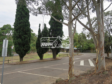
Eltham Gateway, Shilinglaw trees at 895 Main Road, Eltham, site of the former Eltham Shire Council offices. In distance is The Eltham Senior Citizens Hall on Library PlaceTomorrow's history documented todayeltham, jim connor collection, main road, eltham gateway, library place, senior citizen's hall, shillinglaw trees -
 Eltham District Historical Society Inc
Slide, Construction of Eltham Town Park, 22 Feb 1974
Construction of Eltham Town Park, later renamed Alistair Knox Park. In the foreground is where the Diamond Creek Trail runs along the creek and in the distance is the Bridge Street bridge.35 mm colour positive transparency Mount - Agfacolor Service (Blue)alistair knox park, eltham town park, bridge street bridge -
 Lara RSL Sub Branch
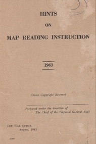
Booklet, Hints of Map Reading Instruction 1943, 00/08/43
Used to instruct the serviceman how to read and question learnt material about map reading. The map as a plan, as a reference point, a measurement of distance, a relief and direction in any situation Paper Booklet with 24 pages that have faded to a beige colour A5 in size ReservedFront page has the name of the booklet with added date 1943. Crown Copyright. Prepared under the direction of the Imperial General Staff The War Office August 1943 22307booklet, map instruction, 1943 -
 Kiewa Valley Historical Society
Undergarment Child, local seemstress or mother
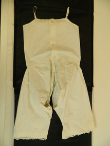
local manufacture either a seemstress or a mother. Time Circa 1920s to 1940s. Distance from towns with haberdasheries would force local manufacture of garments by highly skilled women.Historical period Circa 1920s to 1940s was before easy access to branded manufactured clothes. Majority of basic clothing was hand made either family or skilled friends and neighbours This is Garment is cross referenced to KVHS 0249 and KVHS 0248 and details the growth of a young childGarment has sleeveless top attached to pantaloons at waist and open crotch and going down inner leg seam to 8cm from bottom. Bottom section of each leg adorned with crocheted lace and two pin tucks around bottom of the legs. Top back of garment has three "Mother of Pearl" buttons and narrow 8 mm wide shoulder cross reference to KVHS 0249 and KVHS 0240 straps. Machine stitched cream in colourvest, underwear, child's clothing -
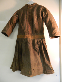 Kiewa Valley Historical Society
Dress
made locally circa 1910. Due to relative long distance to haberdashery stores majority of children's garments were hand made by a local talented seamstress or mother/relativeHistorical significant to the period circa 1900 to circa 1950 when fashion was dictated by long lasting durability, local manufacture, earthy colours and ease of mobility. Photos in the KVHS collection show girls from Tawonga Primary School in a dress that could be this dress which is dated 1910. Dress brown cotton with long sleeves. Dress top and sleeves lined. Back of dress is open with metal hooks for fastening. Hand stitched eyelets and decorative strip down centre front bodice and around hips. Gathered skirt is joined at hip. One pocket on left side 6cm from waist band.Decorative strip at bottom of dress with a pleated hand and machine stitched frill.no inscriptions or markings suggesting locally made.dress, clothing, girl's dress, home made -
 Eltham District Historical Society Inc
Photograph, Leader Publishing Co, Floods at Diamond Creek, Sep. 1924
The Diamond Creek in flood in Diamond Creek township. View north along Diamond Street. The building in the middle distance is the Methodist Church. From "The Leader", 6 September 1924.This photo forms part of a collection of photographs gathered by the Shire of Eltham for their centenary project book, "Pioneers and Painters: 100 years of the Shire of Eltham" by Alan Marshall (1971). The collection of over 500 images is held in partnership between Eltham District Historical Society and Yarra Plenty Regional Library (Eltham Library) and is now formally known as 'The Shire of Eltham Pioneers Photograph Collection.' It is significant in being the first community sourced collection representing the places and people of the Shire's first one hundred years.Digital imageshire of eltham pioneers photograph collection, diamond creek, floods, methodist church, diamond creek (creek), diamond street, 1924 -
 Ballarat Tramway Museum
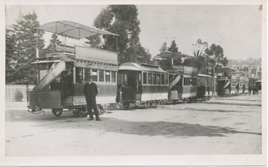
Photograph - Tram trailers - Railway Picnic day Mitchell St, Cyril White, 14/09/1906
Photo of 7 Bendigo Tram trailers - both single and double deck in Mitchell St for the Railway Picnic Day 1906. In the far distance can be seen an electric tram.Yields information about trams used for the Railway Picnic day in 1906.Black and White copy print contained within the Wal Jack Bendigo and Geelong Album, see Reg Item 5003 for more details..1 - On the rear in pencil, "Bendigo Tramway Railway Picnic Day, 14-9-06, Nos. 1st car 9, 14, ?13, ?14", Has Ken Magor stamp in the bottom right-hand corner with the number "3784". On the rear in pencil of second copy from the Ken Magor collection- "Bendigo Victoria, Railway Picnic Day, 14 September 1906. Photo by Cyril White, Mundy St Bendigo. DD Nos. 9, S deck 14, DD No.13, Open and Seat, S deck D No. 12" - see rear image.trams, tramways, bendigo, mitchell st, trailers -
 Stawell Historical Society Inc
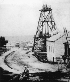
Photograph, Sloane's & Scotchman Mining Co Poppet Head in Upper Main Street Big Hill looking West. c1890
Gentleman sitting in front of Sloane's & Scotchman Mining Co Poppet Head Upper Main Street Big Hill looking West. Main Street visible in distance background.Poppet head above shaft and engine shed at right. Looking towards corner of Main and Lazelle Streets. Man seated at front centre of photo in boater hat.stawell mining, streetscape -
 Melbourne Tram Museum
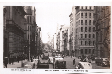
Postcard, Rose Stereograph Co, "Collins Street Looking East Melbourne", c1950
Rose Series postcard No. P 3726 titled "Collins Street Looking East Melbourne" from near Market St. Has several W2 class trams in the distance. Yields information about Collins St from near Market St looking east.Postcard - printed real photograph with Rose Stereograph Co. name on the rear. Unused.trams, tramways, w2 class, collins st. -
Frankston RSL Sub Branch
Heliograph
Signalling heliograph which has been manufactured using a variety of military hardware items. Presumably this heliograph was improvised in the field as a result of damage to a standard issue item. This heliograph has parts which have been sourced from other standard military issue equipment, for example, knobs from cooking pots. The item uses the mirrors which are normally found in the standard issue heliograph. This heliograph has two large mirrors (for long distance signalling) and a smaller mirror (for short distance signalling). The mirrors are mounted on adjustable arms for positioning and aiming.no markings to note -
 Ballarat Tramway Museum
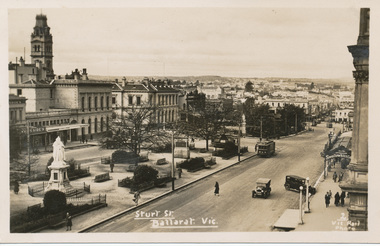
Photograph - Digital image, c1935
Yields information the buildings, buildings and scene in Sturt St looking East from Doveton St.Digital image from the Wal Jack Ballarat Album of a postcard - titled "Sturt St Ballarat Vic", looking east along the south side of Sturt St from Doveton St. Tram in the far distance. Has a number of motor vehicles in the photograph. Has a tram No. 5, at the city tram stop and three trams in the distance in Sturt or Bridge St. Wal has dated the photo 1935 on his album notes. Has a good photo of the City Hall Cafe advertising Swallow's Ice cream. Kodak postcard - see image i2.In bottom right hand corner has the "2 Vic Rail Photo".trams, tramways, esco, sturt st, dawson st, tram 5 -
 Mission to Seafarers Victoria
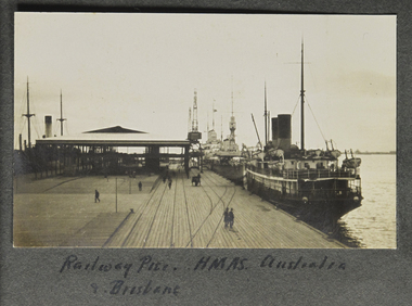
Photograph - Photograph, Sepia, Railway Pier HMAS Australia and Brisbane, Early 20th Century
The HMAS Australia and Brisbane are documented as visiting Port Melbourne circa WW1 and WW2.HMAS Australia has been a significant link and factor in the history of the Mission. Padre Frank Oliver Chaplain from 1930-60 served on the ship in WW2. Cadets and officers also regularly visited the Mission. The pier also played a significant role in the development and life of Melbourne. Small landscape b & w photograph depicting view along a pier with railway lines and three ships ( 2 appear to be naval vessels) moored on the right hand side of the frame. A horse and cart can be seen on the pier in the middle distance. handwritten inscription on the page below the photograph.hmas australia, hmas brisbane, port melbourne pier, station pier, fan album -
 Halls Gap & Grampians Historical Society
Photograph - B/W
Photo shows Charles D'Alton (left) and Fred Paasch (right & seated) looking at a point in the distance. Fred Paasch has arm raised & finger pointed. Both are standing on new & rough section of Mt Victory Rd. Dog in foreground.Charles D'Alton & Frederick Paasch (white hat)access routes, mt victory rd -
 Halls Gap & Grampians Historical Society
Photograph - B/W
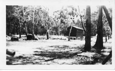
This is a photo of the Halls Gap Recreation area. The building is possibly the change shed for the swimming pool.The photo is a distance shot of a tall narrow building with a pitched roof and small windows high up along the side. There is a metal set of swings/ladder and a lower set of metal equipment near the building. It stands in a cleared area surrounded by bush. recreation, sport -
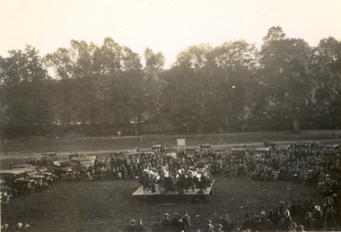 Federation University Historical Collection
Photograph - Black and White, Velox, St Hilda's Band playing at Stanhope, UK, 1934, 1934
Frank Wright was a renown resident of Smeaton, where he was born. He lived at Laura Villa, and attended Smeaton State School. His father William was a gold miner and his mother's name was Sarah. Their family won many singing and instrumental awards. Frank was tutored by Percy Code and was awarded a gold medal for the highest marks in the ALCM examinations in the British Colonies at the age of seventeen years. He became the Australian Open Cornet Champion by the age of eighteen. A year later, Frank conducted the City of Ballarat Band, and later the Ballarat Soldiers’ Memorial Band. He formed the Frank Wright Frisco Band and Frank Wright and his Coliseum Orchestra. These bands won many South Street awards, and Frank as conductor won many awards in the Australian Band Championship contest. In 1933 Frank Wright sailed to England to conduct the famous St Hilda’s Band and was later appointed Musical Director of the London County Council, where he organized many amazing concerts in parks, in and around the London district. He was made Professor of Brass and Military Band Scoring and conducted at the Guildhall of Music and Drama. Frank was often invited to adjudicate Brass Band Championships around Europe, in Australia, including South Street and in New Zealand. The Frank Wright Medal at the Royal South Street competition is awarded to an individual recognized as making an outstanding contribution to brass music in AustraliaBlack and white photograph of a large tree-bordered park. In the middle distance is a crowd of people sitting and standing around a podium containing a band. To the left and behind the crowd, vintage cars are parked. The place is Stanhope in the UK and the band is St Hilda's.Written in pencil on the back - St Hilda's playing at Stanhope, Sept 1934frank wright, cornet, conductor, ballarat, st hilda's band -
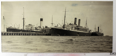 Flagstaff Hill Maritime Museum and Village
Postcard
Black And White postcard of scene, ships at of Port Melbourne. Main ship Is steamship Ormonde, with Nestor in the distance. This card has been cut down in size. 126 mm X 60 mm (Sh 214 Ships M - R)flagstaff hill, warrnambool, shipwrecked-coast, flagstaff-hill, flagstaff-hill-maritime-museum, maritime-museum, shipwreck-coast, flagstaff-hill-maritime-village, port melbourne, ormonde, post card, nestor, steam ships, postcard -
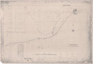 Ringwood and District Historical Society
Map, Road Plan 108 - Gipps-land Road, Parishes of Bulleen and Warrandyte (Ringwood, Victoria) - 1855
Surveyor's map of the part of the main road from Melbourne to Gippsland following "Barker's Track" south of Mullum Mullum or Deep Creek. Map references include Roman numerals marking distances measured in Links between trees at turns in the road.Submitted to the Surveyor General (Signed) July 2nd 1855. -
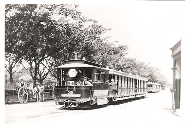 Bendigo Historical Society Inc.
Photograph - BASIL MILLER COLLECTION: STEAM TRAM
Black and white photo of steam tram in centre foreground, 2 horse drawn gigs on left, another tram in distance. Sign visible in top right of photo, 'Albion (?) maybe hotel (?). '(4) written in blue ink on back of photo.person, individual, basil miller -
 Bendigo Historical Society Inc.
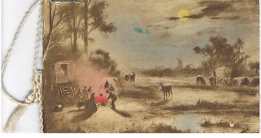
Document - MALONE COLLECTION: GREETING CARDS, 1915
Sepia coloured scene with some coloured areas, the sky, moon, water and the campfire. The scene is a gypsy camp with wagons, horses, donkey, people and dog. They are camped in a wooded area with a windmill in the distance. Card and insert held together with white cord.person, greeting cards, malone collection, malone collection, greeting cards -
 Bendigo Historical Society Inc.
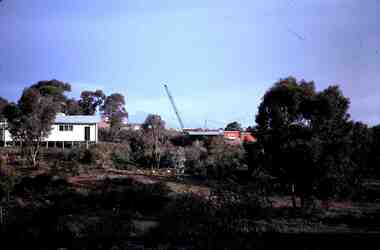
Slide - RALPH BIRRELL COLLECTION: EIG SCHOOL, c1974
EIG School - Ralph Birrell Collection. - Construction of Latrobe Uni. C1974. Bendigo Institute of Technology, Engineering School, Applied Science. Looking from the distance you can see a white building to the left and beyond that a crane working at the university.Kodakeducation, tertiary, latrobe university bendigo, eig school - ralph birrell collection. - construction of latrobe uni. c1974. bendigo institute of technology, engineering school, applied science. looking from distance white building crane -
 Bendigo Historical Society Inc.
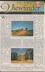
Newspaper - JACK PERRY COLLECTION: NEWSPAPER LIGHTNING HILL
Newspaper article, Bendigo Weekly, on Lightning Hill and Permanent Survey Markers, their importance in mapping, drainage and sewerage planning. Marker on Lightning Hill shows distance and direction to Mr. Ida Heathcote, Pyramid Hill, Mt. Moliagul and Mt. Korong.person, individual, jack perry, lightning hill, permanent survey markers, windmill hill -
Port Melbourne Historical & Preservation Society
Photograph - Horse and cart, Normanby Road, 1930s
Mounted on board, photograph of horse and cart in Normanby Road, c late 1930s, looking southwest toward Port Melbourne from opposite the dry dock and showing railway sheds on the left and in the distance, Laconia Woollen Mills with Dunlop's oppositetransport - horse, dunlop, laconia woollen mills -
 Tatura Irrigation & Wartime Camps Museum
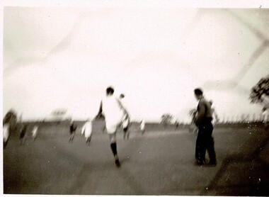
Photograph, Camp 3 Soccer
Internees from Camp 3 playing soccer.Black and white photograph of a man in of centre of photograph with back turned kicking the ball and wearing white shorts and shirt. Man of to right of him in dark long trousers and shirt. Other men in distance, some in white others in dark clothing. camp 3 soccer, camp 3 sport -
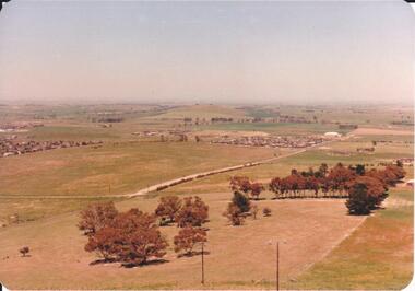 Hume City Civic Collection
Photograph, 1980s
The photograph was taken above Reservoir Road on the lower slopes of Mt. Holden. It is looking south down Wilson's Lane towards some of the early Sunbury developments which grew around the Gap Road area in the early 1980s.A landscape coloured photograph with rounded corners. It is a panoramic view of Sunbury taken from the southern slopes of Mt. Holden. In the foreground there is a small cluster of trees and in the middle distance there is some evidence of housing development. Bald Hill can be seen on the skyline.wilson's lane, mt. holden, bald hill, sunbury, george evans collection