Showing 1735 items matching "groves"
-
 Bialik College
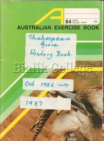
Booklet (item) - Shakespeare Grove History Book 1986-1987, 1986-1987
Scrapbook filled with annotated photographs and newspaper clippings, labelled 'Shakespeare Grove History Book Oct 1986-1987'. Topics include a dance evening at Shakespeare Grove; the Bialik Fete; annual Parents' Association Revue; an audience with Israeli President Chaim Herzog; the first combined Bar and Batmitzvah ceremony; new principal; Book Week; Speech Night play; Pesach play; Jewish education; visit of an Aboriginal cultural group; advertisement; fundraising; school librarian; family maths morning; and the story of IVF triplets starting school at Bialik in 1989. Please contact [email protected] to request access to this record.1980s, jeffrey mahemoff, michael pincus, year 7, barmitzvah, batmitzvah, ben ami shemer, visual and performing arts, event, judaism, kathleen o'donnell, meg rynderman -
 Glen Eira Historical Society
Document - Athole, Poplar Grove, 18, Carnegie
3 page photocopy of an article on Athole, Poplar Grove, 18, Carnegie, from the Caulfield Conservation Study by Andrew Ward in 01/1995. Article includes a description, brief history, state of significance of Athole, poor quality photography and a bibliography.carnegie, poplar grove, athole, kelleher john thomas, rosstown swamp, market gardens, mackay richard, fish kareen, strathnaver estate, land subdivision, architects, brick houses, stables, greenhouses, architectural styles, architectural features -
 Bendigo Historical Society Inc.
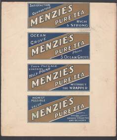
Document - CAMBRIDGE PRESS COLLECTION: LABEL - MENZIE'S PURE TES
Page contains the four sides to a packet of tea. Menzie's Pure Tea printed in dark blue and gold. Each side has Menzie's Pure Tea printed on it, one has the weight of the tea (Half-Pound), another has the address- 5 Ocean Grove and the fourth has Cheerful efficient service, Orders collected and delivered.business, printers, cambridge press, cambridge press collection, menzie's pure tea -
 Hume City Civic Collection
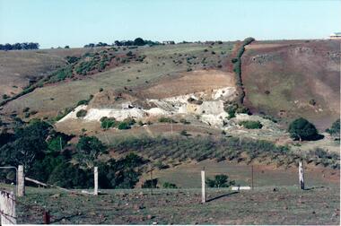
Photograph, c Early 1990's
The Kaolin quarries at Bulla were an important industry in the district and supplied clay products to the Cornwell and Hoffman companies in Brunswick. The Kaolin deposits were found in the 1850's and were considered to be some of the largest in the colony.A landscape photograph of a valley with a post and wire fence and a partial view of a farm gate in the immediate foreground. A clump of native trees are on the LHS and a small grove of almond trees has been planted on the river flat. Kaolin quarry is on the hillside and two buildings can be seen on the hill top. High tension pylons are in the distance near the skyline.kaolin quarries, almond groves, bulla township, deep creek, hoffmans kaolin mine, hoffmans potteries, cornwell potteries, george evans collection -
Kew Historical Society Inc
Archive (series) - Subject File, Andale School, 1981
Various PartiesReference, Research, InformationKHS Imposed OrderReference file containing a 2-page of the history of the Andale School in Highbury Grove, Kew, by Pam Erwin, physical education teacher at the school. The history records the various locations of the school over time. There are also three folders (undated) of promotional material produced by the school. The file also includes various newspaper articles on the school and its students.andale school - kew (vic), schools - kew (vic.)andale school - kew (vic), schools - kew (vic.) -
Kew Historical Society Inc
Archive (Sub-series) - Subject File, DALLEY, Marie (1880-1965) & CASCARRET, Clare, 1958
Various PartiesReference, Research, InformationSecondary Values (KHS Imposed Order)Subject file containing correspondence and newspaper articles/clippings. Correspondence is about naming a street after Marie Dalley. Marie Dalley lived at 31 Miller Grove. A newspaper article from 1981 also identifies 13 Bowen Street (built 1914) as the home of Ma Dalley’s daughter - Mrs Clare Cascarret (1959-76).marie (ma) dalley, mayors of kew, clare cascarret, miller grove - kew (vic.)marie (ma) dalley, mayors of kew, clare cascarret, miller grove - kew (vic.) -
 Bendigo Historical Society Inc.
Postcard - Bendigo postcards
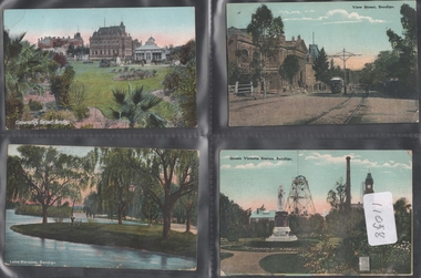
Four hand coloured postcards 1908 addressed to Miss Allie Munro, Continuation School, Gillies Street, Ballarat, from Miss Edith Mason 18 Bancroft Street Bendigo, and Mary Stephens, Parsonage Grove, Eaglehawk. a. Lake Weeroona b. Conservatory Gardens c. View Street, Bendigo d. Queen Victoria Statue postcards, bendigo views -
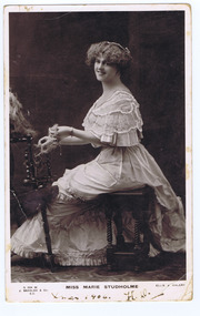 St Kilda Historical Society
Photograph, J Beagles & Co, Marie Studholme Miss, c. 1906
Seated studio portrait of Miss Marie Studholmeblack and white postcard, unmounted, original, fair conditionOn front Xmas 1906. On back Dear Lalla I wish you a Merry Xmas & a Happy New Year. H B Davey. Address Mrs Lall Williams c/- Mrs Williams, the Grove, Morelands Victoria -
 Ringwood and District Historical Society
Map, Partially Trimmed Copy of Elphin Estate, Ringwood, Vic. - (Undated, circa 1940s)
Clipped subdivision map on cardboard backing.Faint handwritten sales notations on and around numbered allotments in Heywood Street, Maidstone Street and Barkly Street, Ringwood.Surrounding streets also include Lutchie Street (later Sylvia Grove) and incorrect spelling of Barkly Street as Barkley. -
Glen Eira Historical Society
Article - Mayfield Grove, 2/2A, Caulfield North
Newspaper advertisement, source unknown, dated 30-/09/2011, giving details concerning the forthcoming auction of 2/2A Mayfield Grove, Caulfield North. Includes one colour photographs of the house exterior and three colour photographs of the house interior.jones noel, mayfield grove, caulfield north, caulfield park, estate agents -
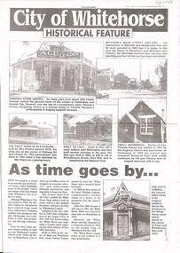 Whitehorse Historical Society Inc.
Article, Historical Feature, 02/10/1996
A3 photocopy of Page 1 Whitehorse Historical Feature dated 2 Oct 1996, of the Whitehorse Post Supplement.non-fictionA3 photocopy of Page 1 Whitehorse Historical Feature dated 2 Oct 1996, of the Whitehorse Post Supplement.pannam's store, woodhouse grove methodist church, pearce mrs, woodhouse grove methodist chapel, burwood east state school no 454, whitehorse hotel -
Bialik College
Album (Sub-series) - 1960s photographs and newspaper articles
-
 City of Kingston
Photograph - Black and white, 20 December 1945
This aerial photograph depicts the changing landscape of Cheltenham and Highett since WWII. Photographed in 1945, there is a mix of urban dwellings and industrial development and precedes the major transformation of Cheltenham with the development of the Southland shopping centre in the 1960s and expansion in the 1990s.A large part of Cheltenham was originally established as a rural market gardening community. The railway line and station brought urban development to the area and in the north, the Highett area was dominated by the Highett Gas Works. Cheltenham became a major destination for shopping in the 1960s with the opening of Southland.Aerial photograph taken in 1945 of Cheltenham and Highett within the City of Kingston. The image includes the Highett Reserve, (top right), the Methodist Children Homes (now Southland), Nepean Highway and Jamieson Street. Highett Gas Works is visible in the top left and the land now named William Fry Reserve at the intersection of Bay Road and Nepean Highway. A visible large parcel of land on the corner of Bay Road and Nepean Highway was developed in the 1990s as the west side addition to Southland. The densely vegetated area in the upper right sector of the image is now dense with housing. Tulip Grove, Heather Grove and Gilford Street are visible bottom left. This image is possibly from the collection of aerial photographs commissioned by the Department of Crown Lands and Survey and taken by Adastra Airways.Black ink: 57252 White lettering: VIC-10 57252 20.12.45 [lens information indecipherable] PROJ. No.5 MELB. METROP AREA Black pencil: 80highett, cheltenham, highett gas works, urbanisation -
 City of Kingston
Photograph - Black and white, 20 December 1945
This aerial photograph depicts the changing landscape of Cheltenham and Highett since WWII. Photographed in 1945, there is a mix of urban dwellings and industrial development and precedes the major transformation of Cheltenham with the development of the Southland shopping centre in the 1960s and expansion in the 1990s.A large part of Cheltenham was originally established as a rural market gardening community. The railway line and station brought urban development to the area and in the north, the Highett area was dominated by the Highett Gas Works. Cheltenham became a major destination for shopping in the 1960s with the opening of Southland.Aerial photograph taken in 1945 of Cheltenham and Highett within the City of Kingston. The image includes the Highett Reserve, (top right), the Methodist Children Homes (now Southland), Nepean Highway and Jamieson Street. Highett Gas Works is visible in the top left and the land now named William Fry Reserve at the intersection of Bay Road and Nepean Highway. A visible large parcel of land on the corner of Bay Road and Nepean Highway was developed in the 1990s as the west side addition to Southland. The densely vegetated area in the upper right sector of the image is now dense with housing. Tulip Grove, Heather Grove and Gilford Street are visible bottom left. This image is possibly from the collection of aerial photographs commissioned by the Department of Crown Lands and Survey and taken by Adastra Airways.Black type: Reverse lettering VIC-10 57252 20.12.45 [lens information indecipherable] PROJ. No.5 MELB. METROP AREA White lettering: Reverse writing 57252cheltenham, highett, highett gas works, urbanisation -
Glen Eira Historical Society
Article - Carrington Grove, 8, St Kilda East
A one page typed report dated 05/08/1989, by H Bullock and R Landells, containing a brief history of the house at 8 Carrington Grove from 1914 to 1989. The report provides a list of occupants and briefly mentions Charles Carrington and Lord Loch after whom Loch Avenue and Carrington Grove was named. The file also includes one page of accompanying handwritten working notes. The file also includes a photocopy of an article from a book, title and publication details unknown, containing a biography of Charles Robert Carrington. A one page research note by Chloe Stapleton, dated 08/05/2012, identifies the source of the article.carrington grove, st kilda east, loch avenue, heads of state, governors, officials, depression 1890s, economic depression, world war 1914-1918, carrington charles robert, harrop thomas s, harrop r, koesis l, mitchell n i, bullock h, landells r -
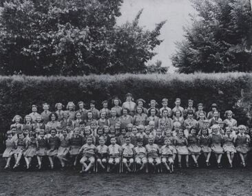 Coburg Historical Society
Black and white photograph of the students of Clare Grammar School, c1948 - 1954
The students of Clare Grammar School, The Grove, Coburg, c1948 - 1954. Names include: 3rd row down - 4th from left - Teddy Lithgow; 7th from left - Peter Weddle. 4th row down - 7th from left - Lorna Patchett.Black and white photographclare grammar school, the grove, coburg -
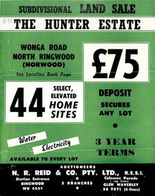 Ringwood and District Historical Society
Flyer, Land Sale Brochure, The Hunter Estate, North Ringwood, Vic. - circa 1960
Bi-fold land sale advertisement for The Hunter Estate, North Ringwood, including terms of sale, area map, layout of the estate, and summary of local facilities and services, with separate attachment listing lot number prices.Subdivision includes Wonga Road, Hunter Avenue (later Graeme Avenue), Panfield Avenue, Hendra Grove, and Mullum Mullum Road. Agent - N.R. Reid & Co. Pty. Ltd., Station Entrance, Ringwood. (Phone) WU 6661. -
Glenelg Shire Council Cultural Collection
Photograph - Photograph - Maiden voyage presentation Mayor Joy Davis, n.d
PPAA (Port of Portland Authority)Back: (names on back of photo) Maiden voyage presentation. L-R Ship's Captain Jack Clayton (PPA Deputy Chairman) Joy Davis(Portland Mayor) Laskie (AWB) Stan Groves (Ship's Agent) Blue Biroport of portland archives, joy davis, portland harbour -
 Orbost & District Historical Society
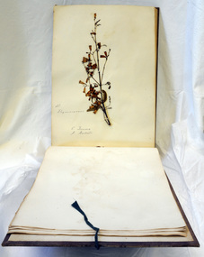
books, 1890's
These albums are attributed to Carl Grove (1849-1939) , first selector at Newmerella, where he planted hops in the 1880's. He was an orbost Shire councillor for 25 years, helped to establish the library and the Mechanics Institute and was one of the first Orbost Butter Factory directors.These albums are significant mainly for their connection to Carl Grove.The collection of live plant specimens from the wild with correct labelling can provide a record to be used for research.Three large books of botanical specimens. Each has a brown cloth cover which has cloth tape ties attached.On front cover - FRONTgrove-carl album plants botany -
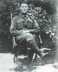 Eltham District Historical Society Inc
Photograph, Warrant Officer Ivor Roy McLachlan, M.S.M., c.1916, 1916c
According to Ivor Roy McLachlan's service record (National Archives of Australia), Ivor's next of kin was his father who lived in Western Australia but Ivor was the adopted son of W. Lack of Pine Grove, Research (Vic.) and had lived there since he was a child.Monochromatic A4 inkjet photographic printivor roy mclachlan, pine grove, research (vic.), w. lack -
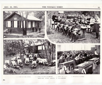 Whitehorse Historical Society Inc.
Photograph, Open Air State School, Blackburn, 01/11/1915
The Open Air School in Laurel Grove Blackburn was established by the Education Department in 1915 to give poor children from inner-city areas who were of 'delicate' health a chance to take advantage of the healthy bush environment of the Blackburn area. The school was closed in 1964.Four Black and White views of Open Air State School, Blackburn showing 1. View of the school 2. Bowl of soup at midday 3. Open air class 4. Interior of school. See History. From Weekly Times. See NP779 in Album 13 - Robyn DeCosta.open air school, no. 3850, blackburn, education department -
Bialik College
Plan (item) - Site development proposals, Shakespeare Grove, 1986
Site development proposals for 6 Shakespeare Grove, Hawthorn, as part of the Bialik College Strategy Plan, created by Jennings Project Management, October 1986. Includes plan of existing land use and site constraints. Please contact [email protected] to request access to this record.1980s, building and planning -
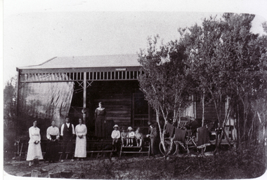
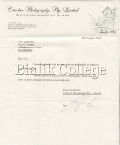 Bialik College
Mixed media (Item) - 4 Shakespeare Grove, Hawthorn, 1965, 1965
Letter sent from Creative Photography Ltd. to Principal Chowers, with photos taken at the College's new building at 4 Shakespeare Grove. In original envelope marked 'Proofs of house purchased as addition to Bialik College'. Please contact [email protected] to request access to this record.facilities, campuses, 1960s -
Whitehorse Historical Society Inc.
Letter - Correspondence, School 2923 Blackburn, 24/05/1978
Letter from Neville Drummond, Victorian Education Department, History Section to Mr C.H. Payne, 6 Morton Grove, Chelsea concerning information on Blackburn Primary School, No 2923, opened in Whitehorse Road, 1 May 1889, also Sagoe Common School, Cr Whitehorse & Middleborough Roads. Also lists schools Nos 1 - 6.victoria. education department. history section, blackburn primary school, no. 2923, sagoe common school, no. 463, primary schools -
 Whitehorse Historical Society Inc.
Photograph, Louis Schwerkolt Holiday Home, c1917
Black and white photograph of Holiday Home of Louis & Francesca (Cissie) Schwerkolt - Ti Tree Grove, Mentone - c1917 - 'Mitcham'. Left to right - Louisa, Cissie, Les and Frances (Dit) Hogan and four children, Alice (middle daughter on verandah). Man in hat is believed to be Van Pruyen, husband of Dora, older sister of Cissie & Dit - it may be Louis Schwerkolt.schwerkolt family, schwerkolt cottage -
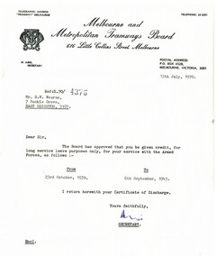 Melbourne Tram Museum
Letter, Melbourne & Metropolitan Tramways Board (MMTB), Long Service Leave, 13/07/1970 12:00:00 AM
Quarto sized, typed letter to R. Wearne of 7 Mackie Grove, East Brighton, dated 13/7/1970 advising that his Army Service from Oct. 1939 to September 1945 will be recognised for Long Service Leave. Signed by Mr Aird? as Secretary. Typed on bond paper with a Heralds Loan, Rag Content, Made in Australia watermark.trams, tramways, mmtb, letters, world war 2 -
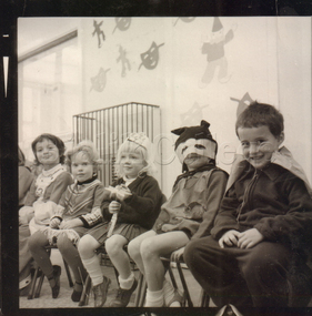 Bialik College
Photograph, Kindergarten students in costume, Shakespeare Grove, 1960s, 1960s
Kindergarten students in the classroom, Shakespeare Grove, 1960s. Students dressed in costume, possibly for Purim celebrations. Students: unknown, Roger Behrend, 3 unknown students, Nathan Erlich. May possible include: Mark Newhouse Please contact [email protected] to request access to this record.purim, elc, early learning centre, judaism -
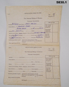 Bendigo Military Museum
Document - APPLICATION FORM
Owner and donor details (See Cat no. 5826 P)1. Application form - paper, off white with black print on front. Applicant information has been partially completed. 2. Application form Part two - paper off white with black print on front.1. Applicant information - handwritten blue ink- "PATTERSON/JAMES WALTER/ 1 NEWCOMB STREET/ OCEAN GROVE/VIC/3226/ 052 561 257/ /SEPT 1945 - MARCH 1946/RAAF/149800/ J W Patterson/ AUSTRALIA" documents, military history, bcof, veterans -
 Glen Eira Historical Society
Album - Album page, Ercildoune (576), Inkerman Street, Circa 1972
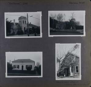
This photograph is part of the Caulfield Historical Album 1972. This album was created in approximately 1972 as part of a project by the Caulfield Historical Society to assist in identifying buildings worthy of preservation. The album is related to a Survey the Caulfield Historical Society developed in collaboration with the National Trust of Australia (Victoria) and Caulfield City Council to identify historic buildings within the City of Caulfield that warranted the protection of a National Trust Classification. Principal photographer thought to be Trevor Hart, member of Caulfield Historical Society. Most photographs were taken between 1966-1972 with a small number of photographs being older and from unknown sources. All photographs are black and white except where stated, with 386 photographs over 198 pages. Vol 1 Caulfield's Building Heritage by Dr Geulah Solomon states that Ercildoune was the home of Sir Samuel Wilson and later, Arthur Knox. Knox is likely the person who subdivided the land, creating Ercildoune Street.Page 100 of Photograph Album with two photographs (landscape) of Ercildoune and two photographs (one landscape and one portrait) of two other houses on Inkerman Street.Handwritten: "Ercildoune" (576) [top left] / Inkerman Street [top right] / 138 INKERMAN ST [under bottom left photo] / LABASSA GROVE CORNER OF INKERMAN OPPOSITE ERCILDOUNE [under bottom right photo] / 100 [bottom right]trevor hart, east st kilda, ercildoune, mansions, towers, gardens, bloomsbury, inkerman road, labassa grove, attic houses, porches, inkerman street, caulfield north, st kilda east, sir samuel wilson, arthur knox, ercildoune street, house names -
 Ringwood and District Historical Society
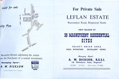
Document - Folder, Land Sale - Leflan Estate, North Ringwood, Vic. - circa 1967
Bi-fold land sale advertisements for stages 1 and 3 releases of residential allotments in Leflan Estate, Ringwood North, circa 1965-1967. Brochures include area map, layout of the estate, and summary of local facilities and services, with separate attachment listing lot number prices for 2nd and 3rd releases.Subdivision includes Melview Drive, Leslie Grove, Leflan Close, Warrandyte Road and Lockhart Street. Agent - A.W. Dickson, R.E.S.I., 136 Whitehorse Road, Ringwood. (Phone) 870-6007, 870-7016, After hours 870-6868.