Showing 826 items
matching historic homes
-
 Kew Historical Society Inc
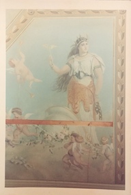
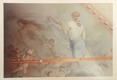
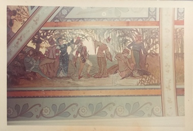
Photograph, Mural, Ballroom, 'South Esk', 1960s
This work forms part of the collection assembled by the historian Dorothy Rogers, that was donated to the Kew Historical Society by her son John Rogers in 2015. The manuscripts, photographs, maps, and documents were sourced by her from both family and local collections or produced as references for her print publications. Many were directly used by Rogers in writing ‘Lovely Old Homes of Kew’ (1961) and 'A History of Kew' (1973), or the numerous articles on local history that she produced for suburban newspapers. Most of the photographs in the collection include detailed annotations in her hand.The Rogers Collection provides a comprehensive insight into the working habits of a historian in the 1960s and 1970s. Together it forms the largest privately-donated collection within the archives of the Kew Historical Society.Small, very faded colour photo of a section of the ballroom ceiling at Southesk (formerly Ordsall)southesk, ordsall, historic houses -- cotham road -- kew (vic.) -
 Kew Historical Society Inc
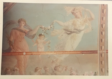
Photograph, Mural, Dining Room, 'South Esk', 1960s
This work forms part of the collection assembled by the historian Dorothy Rogers, that was donated to the Kew Historical Society by her son John Rogers in 2015. The manuscripts, photographs, maps, and documents were sourced by her from both family and local collections or produced as references for her print publications. Many were directly used by Rogers in writing ‘Lovely Old Homes of Kew’ (1961) and 'A History of Kew' (1973), or the numerous articles on local history that she produced for suburban newspapers. Most of the photographs in the collection include detailed annotations in her hand.The Rogers Collection provides a comprehensive insight into the working habits of a historian in the 1960s and 1970s. Together it forms the largest privately-donated collection within the archives of the Kew Historical Society.Small, very faded colour photo of a section of the dining room ceiling at Southesk (formerly Ordsall)southesk, ordsall, historic houses -- cotham road -- kew (vic.) -
 Kew Historical Society Inc
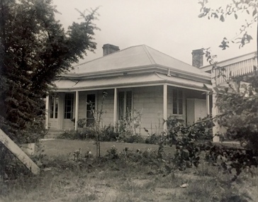
Photograph, J E & B L Rogers, 'Turinville', Barnard Grove, 1950s
This work forms part of the collection assembled by the historian Dorothy Rogers, that was donated to the Kew Historical Society by her son John Rogers in 2015. The manuscripts, photographs, maps, and documents were sourced by her from both family and local collections or produced as references for her print publications. Many were directly used by Rogers in writing ‘Lovely Old Homes of Kew’ (1961) and 'A History of Kew' (1973), or the numerous articles on local history that she produced for suburban newspapers. Most of the photographs in the collection include detailed annotations in her hand.The Rogers Collection provides a comprehensive insight into the working habits of a historian in the 1960s and 1970s. Together it forms the largest privately-donated collection within the archives of the Kew Historical Society.Small, black and white photo of the front of 'Turinville' in Barnard Grove, Kew. "Turinville / Note new addition on right / 11"turinville -- barnard grove -- kew (vic), historic houses -- kew (vic) -
 Kew Historical Society Inc
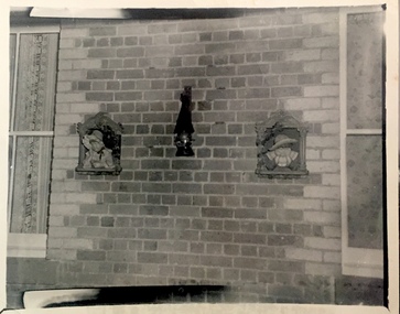
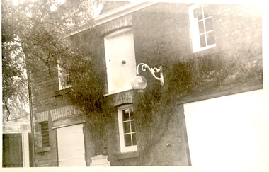
Photograph, J E & B L Rogers, German Plaques, 'Roseneath', Pakington Street, 1950s
This work forms part of the collection assembled by the historian Dorothy Rogers, that was donated to the Kew Historical Society by her son John Rogers in 2015. The manuscripts, photographs, maps, and documents were sourced by her from both family and local collections or produced as references for her print publications. Many were directly used by Rogers in writing ‘Lovely Old Homes of Kew’ (1961) and 'A History of Kew' (1973), or the numerous articles on local history that she produced for suburban newspapers. Most of the photographs in the collection include detailed annotations in her hand.The Rogers Collection provides a comprehensive insight into the working habits of a historian in the 1960s and 1970s. Together it forms the largest privately-donated collection within the archives of the Kew Historical Society.Small, black and white photo of the front of 'Turinville' in Barnard Grove, Kew. "German Plaques. Back wall of Roseneath. 30"roseneath -- pakington street -- kew (vic.), historic houses -- kew (vic) -
 Kew Historical Society Inc
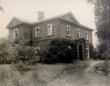
Photograph, J E & B L Rogers, F. Baynes House, Queens Street, 1960s
This work forms part of the collection assembled by the historian Dorothy Rogers, that was donated to the Kew Historical Society by her son John Rogers in 2015. The manuscripts, photographs, maps, and documents were sourced by her from both family and local collections or produced as references for her print publications. Many were directly used by Rogers in writing ‘Lovely Old Homes of Kew’ (1961) and 'A History of Kew' (1973), or the numerous articles on local history that she produced for suburban newspapers. Most of the photographs in the collection include detailed annotations in her hand.The Rogers Collection provides a comprehensive insight into the working habits of a historian in the 1960s and 1970s. Together it forms the largest privately-donated collection within the archives of the Kew Historical Society.Small, black and white photo of a house in Queen Street, Kew."Built 1856. F. Baynes House. Queen St. (Once faced Cotham Rd). Not published. This is side of house - shops now built along frontage".historic houses -- kew (vic.), houses -- queen street -- kew (vic) -
 Kew Historical Society Inc
Photograph, 'Ivy Grange', 1-3 Malmsbury Street, c.1959
This work forms part of the collection assembled by the historian Dorothy Rogers, that was donated to the Kew Historical Society by her son John Rogers in 2015. The manuscripts, photographs, maps, and documents were sourced by her from both family and local collections or produced as references for her print publications. Many were directly used by Rogers in writing ‘Lovely Old Homes of Kew’ (1961) and 'A History of Kew' (1973), or the numerous articles on local history that she produced for suburban newspapers. Most of the photographs in the collection include detailed annotations in her hand.The Rogers Collection provides a comprehensive insight into the working habits of a historian in the 1960s and 1970s. Together it forms the largest privately-donated collection within the archives of the Kew Historical Society.Small black and white photograph of the bluestone mansion, 'Ivy Grange', 1-3 Malmsbury Street, Kew."Ivy Grange"historic houses -- kew (vic), bluestone buildings -- kew (vic.), ivy grange, houses -- malmsbury street -- kew (vic.) -
 Kew Historical Society Inc
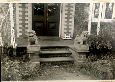
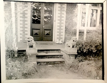
Photograph, Lions, 'Roseneath', Pakington Street, c.1959
This work forms part of the collection assembled by the historian Dorothy Rogers, that was donated to the Kew Historical Society by her son John Rogers in 2015. The manuscripts, photographs, maps, and documents were sourced by her from both family and local collections or produced as references for her print publications. Many were directly used by Rogers in writing ‘Lovely Old Homes of Kew’ (1961) and 'A History of Kew' (1973), or the numerous articles on local history that she produced for suburban newspapers. Most of the photographs in the collection include detailed annotations in her hand.The Rogers Collection provides a comprehensive insight into the working habits of a historian in the 1960s and 1970s. Together it forms the largest privately-donated collection within the archives of the Kew Historical Society.Small black and white photograph of the entrance with guardian lions at Roseneath, Pakington Street, Kew.roseneath -- pakington street -- kew (vic.), historic houses -- kew (vic.) -
 Kew Historical Society Inc
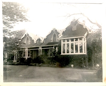
Photograph, 'Roseneath', Pakington Street, c.1959
This work forms part of the collection assembled by the historian Dorothy Rogers, that was donated to the Kew Historical Society by her son John Rogers in 2015. The manuscripts, photographs, maps, and documents were sourced by her from both family and local collections or produced as references for her print publications. Many were directly used by Rogers in writing ‘Lovely Old Homes of Kew’ (1961) and 'A History of Kew' (1973), or the numerous articles on local history that she produced for suburban newspapers. Most of the photographs in the collection include detailed annotations in her hand.The Rogers Collection provides a comprehensive insight into the working habits of a historian in the 1960s and 1970s. Together it forms the largest privately-donated collection within the archives of the Kew Historical Society.Small black and white photograph of Roseneath in Pakington Street, Kew.roseneath -- pakington street -- kew (vic.), historic houses -- kew (vic.) -
 Kew Historical Society Inc
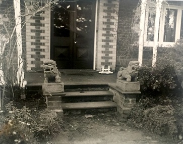
Photograph, Guardian Lions, 'Roseneath', Pakington Street, c.1959
This work forms part of the collection assembled by the historian Dorothy Rogers, that was donated to the Kew Historical Society by her son John Rogers in 2015. The manuscripts, photographs, maps, and documents were sourced by her from both family and local collections or produced as references for her print publications. Many were directly used by Rogers in writing ‘Lovely Old Homes of Kew’ (1961) and 'A History of Kew' (1973), or the numerous articles on local history that she produced for suburban newspapers. Most of the photographs in the collection include detailed annotations in her hand.The Rogers Collection provides a comprehensive insight into the working habits of a historian in the 1960s and 1970s. Together it forms the largest privately-donated collection within the archives of the Kew Historical Society.Small black and white photograph of the guardian lions at the entrance to Roseneath in Pakington Street, Kew."Chinese lions at Roseneath"roseneath -- pakington street -- kew (vic.), historic houses -- kew (vic.) -
 Kew Historical Society Inc
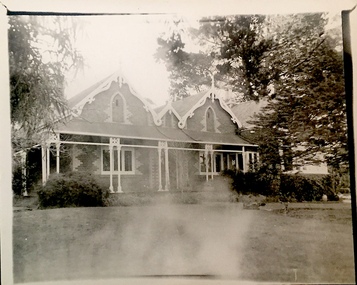
Photograph, 'Roseneath', Pakington Street, c.1959
This work forms part of the collection assembled by the historian Dorothy Rogers, that was donated to the Kew Historical Society by her son John Rogers in 2015. The manuscripts, photographs, maps, and documents were sourced by her from both family and local collections or produced as references for her print publications. Many were directly used by Rogers in writing ‘Lovely Old Homes of Kew’ (1961) and 'A History of Kew' (1973), or the numerous articles on local history that she produced for suburban newspapers. Most of the photographs in the collection include detailed annotations in her hand.The Rogers Collection provides a comprehensive insight into the working habits of a historian in the 1960s and 1970s. Together it forms the largest privately-donated collection within the archives of the Kew Historical Society.Small black and white faded photograph of Roseneath in Pakington Street, Kew."15"roseneath -- pakington street -- kew (vic.), historic houses -- kew (vic.) -
 Kew Historical Society Inc
Photograph, 'Roseneath', Pakington Street, c.1959
This work forms part of the collection assembled by the historian Dorothy Rogers, that was donated to the Kew Historical Society by her son John Rogers in 2015. The manuscripts, photographs, maps, and documents were sourced by her from both family and local collections or produced as references for her print publications. Many were directly used by Rogers in writing ‘Lovely Old Homes of Kew’ (1961) and 'A History of Kew' (1973), or the numerous articles on local history that she produced for suburban newspapers. Most of the photographs in the collection include detailed annotations in her hand.The Rogers Collection provides a comprehensive insight into the working habits of a historian in the 1960s and 1970s. Together it forms the largest privately-donated collection within the archives of the Kew Historical Society.Small black and white faded photograph of Roseneath in Pakington Street, Kew."14"roseneath -- pakington street -- kew (vic.), historic houses -- kew (vic.) -
 Kew Historical Society Inc
Photograph, Guardian Lions, 'Roseneath', Pakington Street, c.1959
This work forms part of the collection assembled by the historian Dorothy Rogers, that was donated to the Kew Historical Society by her son John Rogers in 2015. The manuscripts, photographs, maps, and documents were sourced by her from both family and local collections or produced as references for her print publications. Many were directly used by Rogers in writing ‘Lovely Old Homes of Kew’ (1961) and 'A History of Kew' (1973), or the numerous articles on local history that she produced for suburban newspapers. Most of the photographs in the collection include detailed annotations in her hand.The Rogers Collection provides a comprehensive insight into the working habits of a historian in the 1960s and 1970s. Together it forms the largest privately-donated collection within the archives of the Kew Historical Society.Small black and white photograph of the guardian lions at the entrance to Roseneath in Pakington Street, Kew."26"roseneath -- pakington street -- kew (vic.), historic houses -- kew (vic.) -
 Kew Historical Society Inc
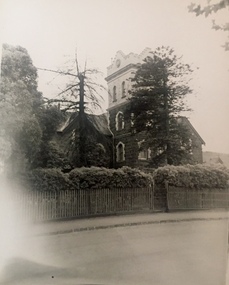
Photograph, 'Campion Hall', Studley Park Road, c.1960
This work forms part of the collection assembled by the historian Dorothy Rogers, that was donated to the Kew Historical Society by her son John Rogers in 2015. The manuscripts, photographs, maps, and documents were sourced by her from both family and local collections or produced as references for her print publications. Many were directly used by Rogers in writing ‘Lovely Old Homes of Kew’ (1961) and 'A History of Kew' (1973), or the numerous articles on local history that she produced for suburban newspapers. Most of the photographs in the collection include detailed annotations in her hand.The Rogers Collection provides a comprehensive insight into the working habits of a historian in the 1960s and 1970s. Together it forms the largest privately-donated collection within the archives of the Kew Historical Society.Small black and white photograph of 'Campion Hall' (previously called Dalswraith and Glendalough) in Studley Park Road, Kew."Ca. 1905 / Campion College / built for S.W. Gibson"historic houses -- kew (vic.), campion hall -- house, glendalough, dalswraith-- dalsraith, kew mansions -
 Kew Historical Society Inc
Photograph, Stables, 'Roseneath', Pakington Street, c.1960
This work forms part of the collection assembled by the historian Dorothy Rogers, that was donated to the Kew Historical Society by her son John Rogers in 2015. The manuscripts, photographs, maps, and documents were sourced by her from both family and local collections or produced as references for her print publications. Many were directly used by Rogers in writing ‘Lovely Old Homes of Kew’ (1961) and 'A History of Kew' (1973), or the numerous articles on local history that she produced for suburban newspapers. Most of the photographs in the collection include detailed annotations in her hand.The Rogers Collection provides a comprehensive insight into the working habits of a historian in the 1960s and 1970s. Together it forms the largest privately-donated collection within the archives of the Kew Historical Society.Small black and white photograph of the stables at the rear of Roseneath in Pakington Street, Kew."33"historic houses -- kew (vic.), roseneath -- pakington street -- kew (vic.) -
 Kew Historical Society Inc
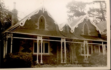
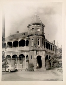
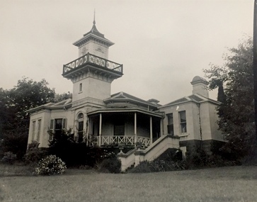
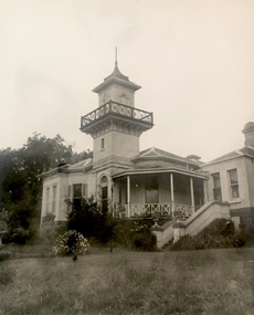
Photograph, 'Ramornie', Pakington Street, c.1960
This work forms part of the collection assembled by the historian Dorothy Rogers, that was donated to the Kew Historical Society by her son John Rogers in 2015. The manuscripts, photographs, maps, and documents were sourced by her from both family and local collections or produced as references for her print publications. Many were directly used by Rogers in writing ‘Lovely Old Homes of Kew’ (1961) and 'A History of Kew' (1973), or the numerous articles on local history that she produced for suburban newspapers. Most of the photographs in the collection include detailed annotations in her hand.The Rogers Collection provides a comprehensive insight into the working habits of a historian in the 1960s and 1970s. Together it forms the largest privately-donated collection within the archives of the Kew Historical Society.Small black and white photograph of the tower and verandas of Ramornie in Pakington Street, Kew.."Commenced 1890 by J.M. Campbell / Ramornie now The Towers / 18"historic houses -- kew (vic.), ramornie -- pakington street -- kew (vic.), the towers -- pakington street -- kew (vic), james maitland campbell -
 Kew Historical Society Inc
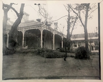
Photograph, J E & B L Rogers, 'Turinville', Barnard Grove, c.1960
This work forms part of the collection assembled by the historian Dorothy Rogers, that was donated to the Kew Historical Society by her son John Rogers in 2015. The manuscripts, photographs, maps, and documents were sourced by her from both family and local collections or produced as references for her print publications. Many were directly used by Rogers in writing ‘Lovely Old Homes of Kew’ (1961) and 'A History of Kew' (1973), or the numerous articles on local history that she produced for suburban newspapers. Most of the photographs in the collection include detailed annotations in her hand.The Rogers Collection provides a comprehensive insight into the working habits of a historian in the 1960s and 1970s. Together it forms the largest privately-donated collection within the archives of the Kew Historical Society.Small black and white photograph of the verandas of Turinville, Barnard Grove, Kew."Turinville, ca. 1846. / Built for J. W. Cowell / (1st house in Kew)"historic houses -- kew (vic.), j w cowell, turinville -- barnard grove -- kew (vic.) -
 Kew Historical Society Inc
Photograph, 'Otira', Walpole Street, c.1960
This work forms part of the collection assembled by the historian Dorothy Rogers, that was donated to the Kew Historical Society by her son John Rogers in 2015. The manuscripts, photographs, maps, and documents were sourced by her from both family and local collections or produced as references for her print publications. Many were directly used by Rogers in writing ‘Lovely Old Homes of Kew’ (1961) and 'A History of Kew' (1973), or the numerous articles on local history that she produced for suburban newspapers. Most of the photographs in the collection include detailed annotations in her hand.The Rogers Collection provides a comprehensive insight into the working habits of a historian in the 1960s and 1970s. Together it forms the largest privately-donated collection within the archives of the Kew Historical Society.Small black and white photograph of Otira in Walpole Street, Kew."Otira commenced 1887 by Henry Berry / 15"historic houses -- kew (vic.), henry berry, otira -- walpole street -- kew (vic.) -
 Kew Historical Society Inc
Photograph, 'Otira', Walpole Street, c.1960
This work forms part of the collection assembled by the historian Dorothy Rogers, that was donated to the Kew Historical Society by her son John Rogers in 2015. The manuscripts, photographs, maps, and documents were sourced by her from both family and local collections or produced as references for her print publications. Many were directly used by Rogers in writing ‘Lovely Old Homes of Kew’ (1961) and 'A History of Kew' (1973), or the numerous articles on local history that she produced for suburban newspapers. Most of the photographs in the collection include detailed annotations in her hand.The Rogers Collection provides a comprehensive insight into the working habits of a historian in the 1960s and 1970s. Together it forms the largest privately-donated collection within the archives of the Kew Historical Society.Small black and white photograph of Otira in Walpole Street, Kew."Otira Henry Berry / commenced 1887 / 2 of this house"historic houses -- kew (vic.), henry berry, otira -- walpole street -- kew (vic.) -
 Kew Historical Society Inc
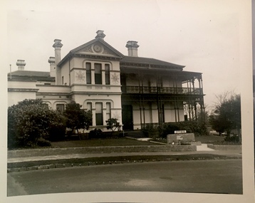
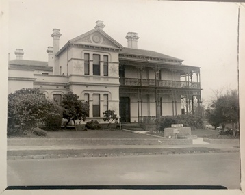
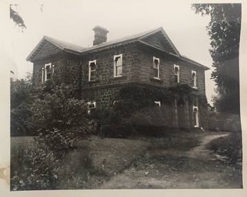
Photograph, 'D'Estaville', 7 Barry Street, c.1960
This work forms part of the collection assembled by the historian Dorothy Rogers, that was donated to the Kew Historical Society by her son John Rogers in 2015. The manuscripts, photographs, maps, and documents were sourced by her from both family and local collections or produced as references for her print publications. Many were directly used by Rogers in writing ‘Lovely Old Homes of Kew’ (1961) and 'A History of Kew' (1973), or the numerous articles on local history that she produced for suburban newspapers. Most of the photographs in the collection include detailed annotations in her hand.The Rogers Collection provides a comprehensive insight into the working habits of a historian in the 1960s and 1970s. Together it forms the largest privately-donated collection within the archives of the Kew Historical Society.Small black and white photograph of 'D'Estaville', 7 Barry Street, Kew."D'Estaville"historic houses -- kew (vic.), d'estaville --- 7 barry street -- kew (vic), sir william stawell -
 Kew Historical Society Inc
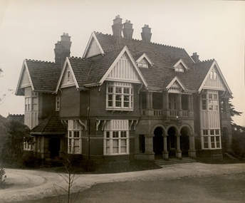
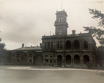
Photograph, 'Raheen', Studley Park Road, c.1960
This work forms part of the collection assembled by the historian Dorothy Rogers, that was donated to the Kew Historical Society by her son John Rogers in 2015. The manuscripts, photographs, maps, and documents were sourced by her from both family and local collections or produced as references for her print publications. Many were directly used by Rogers in writing ‘Lovely Old Homes of Kew’ (1961) and 'A History of Kew' (1973), or the numerous articles on local history that she produced for suburban newspapers. Most of the photographs in the collection include detailed annotations in her hand.The Rogers Collection provides a comprehensive insight into the working habits of a historian in the 1960s and 1970s. Together it forms the largest privately-donated collection within the archives of the Kew Historical Society.Small black and white photograph of 'Raheen', in Studley Park Road, Kew."Raheen by Ed. Latham / (Palace of Roman Catholic Archbishop / 18 / 2 views - either one"historic houses -- kew (vic.), edward latham, raheen -
 Kew Historical Society Inc
Photograph, 'Swinton', Swinton Avenue, c.1960
This work forms part of the collection assembled by the historian Dorothy Rogers, that was donated to the Kew Historical Society by her son John Rogers in 2015. The manuscripts, photographs, maps, and documents were sourced by her from both family and local collections or produced as references for her print publications. Many were directly used by Rogers in writing ‘Lovely Old Homes of Kew’ (1961) and 'A History of Kew' (1973), or the numerous articles on local history that she produced for suburban newspapers. Most of the photographs in the collection include detailed annotations in her hand.The Rogers Collection provides a comprehensive insight into the working habits of a historian in the 1960s and 1970s. Together it forms the largest privately-donated collection within the archives of the Kew Historical Society.Small black and white photograph of 'Swinton' in Swinton Avenue, Kew."Swinton. Ca. 1859 / Built for Edmund Lskey Splatt / 16"historic houses -- kew (vic.), edmund laskey splatt, swinton -
 Kew Historical Society Inc
Photograph, 'Rangeview', Mary Street, c.1960
This work forms part of the collection assembled by the historian Dorothy Rogers, that was donated to the Kew Historical Society by her son John Rogers in 2015. The manuscripts, photographs, maps, and documents were sourced by her from both family and local collections or produced as references for her print publications. Many were directly used by Rogers in writing ‘Lovely Old Homes of Kew’ (1961) and 'A History of Kew' (1973), or the numerous articles on local history that she produced for suburban newspapers. Most of the photographs in the collection include detailed annotations in her hand.The Rogers Collection provides a comprehensive insight into the working habits of a historian in the 1960s and 1970s. Together it forms the largest privately-donated collection within the archives of the Kew Historical Society.Small black and white photograph of 'Rangeview' in Mary Street, Kew."Rangeview. Chapter 52. Commenced about 1880. Now altered to Baptist Hostel"historic houses -- kew (vic.), rangeview -- mary street -- kew (vic.) -
 Kew Historical Society Inc
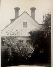
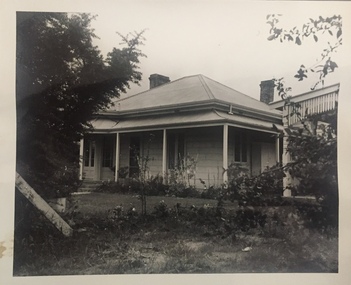
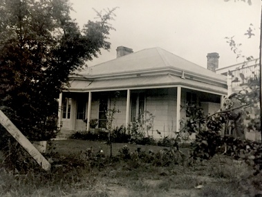
Photograph, 'Houghton', Princess Street, c.1960
This work forms part of the collection assembled by the historian Dorothy Rogers, that was donated to the Kew Historical Society by her son John Rogers in 2015. The manuscripts, photographs, maps, and documents were sourced by her from both family and local collections or produced as references for her print publications. Many were directly used by Rogers in writing ‘Lovely Old Homes of Kew’ (1961) and 'A History of Kew' (1973), or the numerous articles on local history that she produced for suburban newspapers. Most of the photographs in the collection include detailed annotations in her hand.The Rogers Collection provides a comprehensive insight into the working habits of a historian in the 1960s and 1970s. Together it forms the largest privately-donated collection within the archives of the Kew Historical Society.Small black and white photograph of 'Houghton' (now demolished) in Princess Street, Kew."Houghton. ca. 1860 / 17"historic houses -- kew (vic.), houghton -- princess street -- kew (vic.) -
 Kew Historical Society Inc
Photograph, 'D'Estaville', 7 Barry Street, c.1960
This work forms part of the collection assembled by the historian Dorothy Rogers, that was donated to the Kew Historical Society by her son John Rogers in 2015. The manuscripts, photographs, maps, and documents were sourced by her from both family and local collections or produced as references for her print publications. Many were directly used by Rogers in writing ‘Lovely Old Homes of Kew’ (1961) and 'A History of Kew' (1973), or the numerous articles on local history that she produced for suburban newspapers. Most of the photographs in the collection include detailed annotations in her hand.The Rogers Collection provides a comprehensive insight into the working habits of a historian in the 1960s and 1970s. Together it forms the largest privately-donated collection within the archives of the Kew Historical Society.Small black and white photograph of 'D'Estaville', 7 Barry Street, Kew."D'Estaville / built 1857 for Sir Wm Foster Stawell"historic houses -- kew (vic.), d'estaville -- 7 barry street -- kew (vic.), sir william foster stawell -
 Kew Historical Society Inc
Photograph, 'Houghton', Princess Street, c.1960
This work forms part of the collection assembled by the historian Dorothy Rogers, that was donated to the Kew Historical Society by her son John Rogers in 2015. The manuscripts, photographs, maps, and documents were sourced by her from both family and local collections or produced as references for her print publications. Many were directly used by Rogers in writing ‘Lovely Old Homes of Kew’ (1961) and 'A History of Kew' (1973), or the numerous articles on local history that she produced for suburban newspapers. Most of the photographs in the collection include detailed annotations in her hand.The Rogers Collection provides a comprehensive insight into the working habits of a historian in the 1960s and 1970s. Together it forms the largest privately-donated collection within the archives of the Kew Historical Society.Small black and white photograph of 'Houghton (demolished)', Princess Street, Kew."Houghton"historic houses -- kew (vic.), houghton -- princess street -- kew (vic.) -
 Kew Historical Society Inc
Photograph, 'Houghton', Princess Street, c.1960
This work forms part of the collection assembled by the historian Dorothy Rogers, that was donated to the Kew Historical Society by her son John Rogers in 2015. The manuscripts, photographs, maps, and documents were sourced by her from both family and local collections or produced as references for her print publications. Many were directly used by Rogers in writing ‘Lovely Old Homes of Kew’ (1961) and 'A History of Kew' (1973), or the numerous articles on local history that she produced for suburban newspapers. Most of the photographs in the collection include detailed annotations in her hand.The Rogers Collection provides a comprehensive insight into the working habits of a historian in the 1960s and 1970s. Together it forms the largest privately-donated collection within the archives of the Kew Historical Society.Small black and white photograph of 'Houghton (demolished)', Princess Street, Kew.historic houses -- kew (vic.), houghton -- princess street -- kew (vic.) -
 Kew Historical Society Inc
Photograph, 'Swinton', Swinton Avenue, c.1960
This work forms part of the collection assembled by the historian Dorothy Rogers, that was donated to the Kew Historical Society by her son John Rogers in 2015. The manuscripts, photographs, maps, and documents were sourced by her from both family and local collections or produced as references for her print publications. Many were directly used by Rogers in writing ‘Lovely Old Homes of Kew’ (1961) and 'A History of Kew' (1973), or the numerous articles on local history that she produced for suburban newspapers. Most of the photographs in the collection include detailed annotations in her hand.The Rogers Collection provides a comprehensive insight into the working habits of a historian in the 1960s and 1970s. Together it forms the largest privately-donated collection within the archives of the Kew Historical Society.Small black and white photograph of 'Swinton', Swinton Avenue, Kew.historic houses -- kew (vic.), swinton -- swinton avenue -- kew (vic.) -
 Kew Historical Society Inc
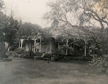
Photograph, 'Villa Alba', Walmer Street, c.1960
This work forms part of the collection assembled by the historian Dorothy Rogers, that was donated to the Kew Historical Society by her son John Rogers in 2015. The manuscripts, photographs, maps, and documents were sourced by her from both family and local collections or produced as references for her print publications. Many were directly used by Rogers in writing ‘Lovely Old Homes of Kew’ (1961) and 'A History of Kew' (1973), or the numerous articles on local history that she produced for suburban newspapers. Most of the photographs in the collection include detailed annotations in her hand.The Rogers Collection provides a comprehensive insight into the working habits of a historian in the 1960s and 1970s. Together it forms the largest privately-donated collection within the archives of the Kew Historical Society.Small black and white photograph of 'Villa Alba', Walmer Street, Kew.historic houses -- kew (vic.), villa alba -- walmer street -- kew (vic.)