Showing 1661 items
matching maps and documents
-
 Bendigo Military Museum
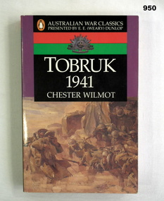
Book, Chester Wilmot, Tobruk 1941, 1993
Book is part of the Australian War Classics series presented by E E (Weary) Dunlop. Author documents the story of the fighting in & around Tobruk from January to December 1941.Book, soft cover, cardboard, white colour print on front, back & spine, cover illustrations - Troops debussing in a sand storm, Libya by Ivor Hele, purple, black, red & green colour background. Rising Sun badge on front & back covers, 348 cut plain pages, illustrated black & white coloured maps.Handwritten in blue colour ink on front flyleaf: F Fuller In black ink on front title page & page 348 - RSL Stampbooks, military history -
 Federation University Historical Collection
Document, C.E. Hounam et al, Commonwealth of Australia Bureau of Meteorology - Climate of the Basaltic Plains of Western Victoria, 1963
... maps ...Brown cardboard covered foolscap sized typed document with diagrams Handwritten on front. Symposium - Royal Society of Victoria "Basaltic Plains of Victoria" 12 September 1963basaltic plains of victoria, royal society of victoria, commonwealth of australia bureau of meteorology, c.e. hounam, f.a. powell, symposium, maps -
 Federation University Historical Collection
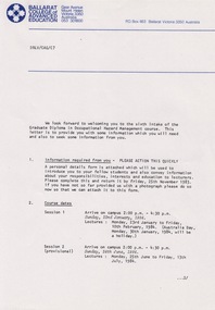
Document - Document - Information, VIOSH: Graduate Diploma in Occupational Hazard Management - Intake 6, 1984, Information Letter to students
Victorian Institute of Occupational Safety and Health (VIOSH) Australia is the Asia-Pacific centre for teaching and research in occupational health and safety (OHS) and is known as one of Australia's leaders on the field. VIOSH has a global reputation for its innovative approach within the field of OHS management. VIOSH had its first intake of students in 1979. At that time the Institution was known as the Ballarat College of Advanced Education. In 1990 it became known as Ballarat University College, then in 1994 as University of Ballarat. It was 2014 that it became Federation University. VIOSH Australia students are safety managers, senior advisors and experienced OHS professionals. They come from all over Australia and industry. Students are taught active research and enquiry; rather than textbook learning and a one-size fits all approach. VIOSH accepts people into the Graduate Diploma of Occupational Hazard Management who have no undergraduate degree - on the basis of extensive work experience and knowledge. Information letter sent to those in Intake 6 of the Graduate Diploma of Occupational Hazard Management Course, 1984. It outlines the timetable for subjects and times at the Ballarat College of Advanced Education. Include in the package is a form that must be completed and returned ASAP. Residences are provided and items included are listed. Transport for those coming from interstate can be arranged. Derek Viner is the Course Co-ordinator.Twenty-three A4 pages, typed with diagrams, mapsHand written note in blue pen on map. Letter head of Ballarat College of Advance Education on some pages. Signature of Derek Viner, Course Co=ordinator.viosh, victorian institute of occupational safety and health, derek viner, course co-ordinator, occupational hazard management, residence, timetable, ballarat college of advanced education -
 Federation University Historical Collection
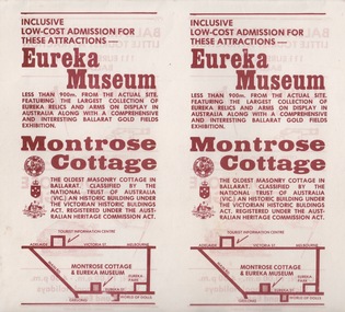
Document - Document - Advertising Cards, ZILLES COLLECTION: Advertising Card for Historic Montrose Cottage and Eureka Museum
Zilles Printers was begun by Lewis Zilles in the early 1930s. It was in McKenzie Street Ballarat. His son Jeffrey also became a printer - letterpress, offset and screen printer. The business became Zilles Printers/Graphics and was in Armstrong Street and later Bell Street Ballarat. Montrose Cottage was build c1856 by John Alexander, builder. He was a Scottish stone mason. It was built with bluestone and hand-made bricks. It is on the Historic Buildings Register, National Trust (Victoria). It is important as a substantial and very early stone cottage. The house is now open to the public. It also provides short term accommodation - self contained apartments. Double sided cards advertising Montrose Cottage and Eureka Museum. Printed by Zilles Graphic Industries, Ballarat. White card with russet colour print. Printed on both sides. Each side has Eureka Museum and Montrose CottageEureka Flag and Cannon. Drawing of Montrose Cottage and flag with Lion. Symbol of National Trust Australia. Coat of Arms. Location map.zilles graphic industries, montrose cottage, eureka musuem -
 Bendigo Military Museum
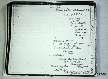
Literary work - DIARY, 1940
... documents ...Colin George ODLUM No VX45898 enlisted In the 2nd AIF on 1.7.1940 age 22 years. Colin was then posted to the 2/23rd Bn on 16.10.1940 at Bonegilla, embarked on 16.11.40 for the Middle East and disembarked on 17.12.1940. He was then graded group 2 Signaller. He went through the siege of Tobruk. Colin was KIA on 12.7.1942 at El Alamein. He is listed as buried 13.7.1942 grave No 11 map ref El Alamein 1/50000 87703021. He was required later at El Alamein cemetery grave 10, plot 8 row H 4.12.1942. As per the diary in case of his death he allotted any personnel affects to Miss Bettie Bird, refer 136.2P. The original diary was held by William (Billy) Bird, Betties brother, refer 1601. Billy and Colin rode bikes together. Also refer 128.2, 135.2, 137.3PPhotocopy of an extensive 56 page diary written by Colin ODLUM.Private Odlum C.G VX45898 HQ Coy 2/23 Batt AIF Abroad, Age 24, A2, Mdocuments, diaries, copies, military history -
 Bendigo Military Museum
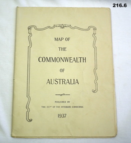
Map - MAPS, 1937
... MAPS ...Items saved by Maurice Anthony BYRNE RAAF. Refer Cat No 215.9 for service history..1) map details on the map with biro lines marking the route taken by a traveller 1937 .2) map printed both sides Western New Guinea B6 December 1943 .3) map sheet B6 January 1944 top part of Australia .4) map Australia north plotting sheet .5) map C4 June 1943 .6) map Australian Aeronautical C5 June 1943documents - maps, military equipment -
 Bendigo Military Museum
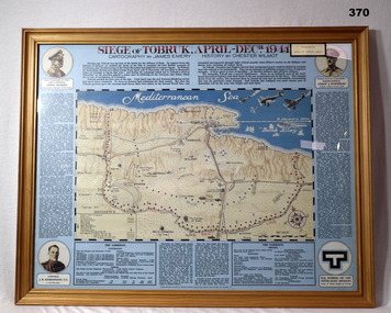
Map - MAP, FRAMED, Siege of Tobruk, Post 1945
Map & detailed description on framed information board. Tan coloured wooden frame, glass front, masonite backing, coloured detailed map of Tobruk area with history of area featured on blue border around map.Siege of Tobruk April - Dec 1941.documents-maps, frame accessories, tobruk -
 Flagstaff Hill Maritime Museum and Village
Book, Journal of Landsboroughs Expedition
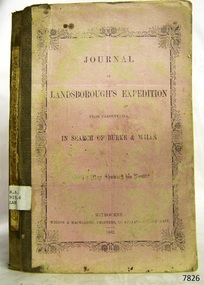
WARRNAMBOOL MECHANICS’ INSTITUTE Warrnambool's Mechanics' Institute (or Institution as it was sometimes called) was one of the earliest in Victoria. On 17th October 1853 a meeting was held where it was resolved to request the Lieutenant Governor of the Colony to grant land for the erection of a Mechanics' Institutes building. A committee was formed at the meeting and Richard Osburne chaired the first meeting of this committee. The land on the North West corner of Banyan and Merri Streets was granted but there were no funds to erect the building. The Formal Rights of the Warrnambool Mechanics' Institute's encompassed its aims and these were officially adopted in1859; "This Institution has for its object the diffusion of literary, scientific, and other useful knowledge amongst its members, excluding all controversial subjects, religious or political. These objects are sought to be obtained by means of a circulating library, a reading room, the establishment of classes, debates, and the occasional delivery of lectures on natural and experimental philosophy, mechanics, astronomy, chemistry, natural history, literature, and the useful and ornamental arts, particularly those which have a more immediate reference to the colony." The Warrnambool Mechanics' Institute opened its first reading room in November1884 in the National School building at the corner of Banyan and Timor Streets. The Institute was funded by member subscription, payable on a quarterly, half yearly or yearly basis. Samuel Hannaford, the Manager of the Warrnambool Bank of Australasia, was the first Honorary Secretary of the Mechanics' Institutes, and an early President and Vice-President. He also gave several of the early lectures in the Reading Room. Another early Secretary, Librarian and lecturer was Marmaduke Fisher, the teacher at the National School. Lecture topics included The Poets and Poetry of Ireland', 'The Birth and Development of the Earth', 'The Vertebrae - with Remarks on the pleasures resulting from the study of Natural History' and 'Architecture'. In 1856 the Reading Room was moved to James Hider's shop in Timor Street, and by 1864 it was located in the bookshop of Davies and Read. In the 1860's the Mechanics' Institute struggled as membership waned but in 1866, after a series of fund raising efforts, the committee was able to purchase land in Liebig Street, on a site then called Market Square, between the weighbridge and the fire station. A Mechanics' Institute building was opened at this site in August 1871. The following year four more rooms were added to the main Reading Room and in 1873 the Artisan School of Design was incorporated into the Institute. The same year Joseph Archibald established a Museum; however it deteriorated when he was transferred to Bendigo in 1877. In 1880, with Archibald's return to Warrnambool, the Museum was re-established, and in 1885 a new building was built at the back of the Institute to accommodate the re-created School of Design, the Art Gallery and the Museum. In 1887 the Museum section was moved to the former court house in Timor Street (for some time the walls of the building formed part of the TAFE cafeteria but all is now demolished)). In 1911 the Museum was transferred back to the original building and the management of the Mechanics' Institute was handed over to the Warrnambool City Council. The Museum and Art Gallery became one and housed many fine works of art, and the Library continued to grow. The building was well patronised, with records showing that at the beginning of the 20th century there were between 500 and 800 visitors. During World War One the monthly figures were in the thousands, with 3,400 people visiting in January 1915. The Museum was a much loved Institution in Warrnambool until the contents of the Museum and Art Gallery were removed to make room for the Warrnambool City Council Engineers' Department. The contents were stored but many of the items were scattered or lost. When the original building was demolished the site became occupied by the Civic Centre, which included the new City Library. (The library was temporarily located in the old Palais building in Koroit Street.) In the process of reorganisation the Collection was distributed amongst the community groups: -The new City Library took some of the historic books and some important documents, historic photographs and newspapers. -The Art Gallery kept the 19th Century art collection and some of the artefacts from the museum. -The Historic Society has some items -The State Museum has some items -Some items were destroyed -Flagstaff Hill Maritime Village has old newspapers, Government Gazettes, most of the Mechanics' Institute Library, ledgers and documents connected to the Mechanics' Institute Library, some framed and unframed art works and some photographs. The Warrnambool Mechanics' Institute Library book collection is deemed to be of great importance because it is one of the few collections in an almost intact state, and many of the books are now very rare and of great value. Journal of Landsboroughs Expedition From Carpentaria in search of Burke and Wills (maps missing) Publisher: Wilson & Mackinnon Date: 1862Label on spine cover with typed text RA 919.4 LAN Pastedown front endpaper has sticker from Warrnambool Mechanics Institute and Free Librarywarrnambool, shipwrecked-coast, flagstaff-hill, flagstaff-hill-maritime-museum, maritime-museum, shipwreck-coast, flagstaff-hill-maritime-village, shipwrecked-artefact, great ocean road, book, warrnambool library, warrnambool mechanics’ institute, mechanics’ institute library, victorian library board, warrnambool books and records, warrnambool children’s library, warrnambool public library, journal of landsboroughs expedition, carpentaria, wilson & mackinnon -
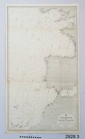
 Flagstaff Hill Maritime Museum and Village
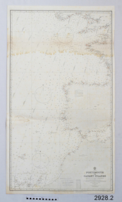
Document - Navigation Chart, Portsmouth to Canary Islands, CA. 1928
Navigation charts are drawn by professional hydrographers and describe the geography of land and water, enabling a water based navigator on board vessels such as ships to safely negotiate between ports locally and around the world. They are drawn to a particular standard with common symbols noting landmarks. The charts are used in conjunction with other navigational instruments and tools to calculate the vessel’s exact location and a safe route to its destination.The set of charts and their chart are of significance as examples of equipment and documents used to navigate the oceans of the world, particularly to Australia. Migration to Australia is an important part of this country's history.British Admiralty Navigation Chart - Portsmouth to Canary Islands - printed on rectangular white paper. Published in London by the British Admiralty in 1928.warrnambool, shipwreck coast, flagstaff hill, flagstaff hill maritime museum, flagstaff hill maritime village, chart, map, navigate, navigation, location, vessel, 1928, british admiralty, hydrographer, geography, admiralty chart, portsmouth, canary islands -
 Flagstaff Hill Maritime Museum and Village
Document - Navigation Chart, Portsmouth to Canary Islands, Ca. 1928
This is an Official British Admiralty Navigation Chart, one of a set of 65 charts donated together with a wooden chart case. It was published and printed in London in 1928 by the British Admiralty. Navigation charts are drawn by professional hydrographers and describe the geography of land and water, enabling a water based navigator on board vessels such as ships to safely negotiate between ports locally and around the world. They are drawn to a particular standard with common symbols noting landmarks. The charts are used in conjunction with other navigational instruments and tools to calculate the vessel’s exact location and a safe route to its destination.The set of charts and their chart are of significance as examples of equipment and documents used to navigate the oceans of the world, particularly to Australia. Migration to Australia is an important part of this country's history.British Admiralty Navigation Chart - Portsmouth to Canary Islands - printed on rectangular white paper. Published in London by the British Admiralty in 1928.warrnambool, shipwreck coast, flagstaff hill, flagstaff hill maritime museum, flagstaff hill maritime village, chart, map, navigate, navigation, location, vessel, 1928, british admiralty, hydrographer, geography, admiralty chart, portsmouth, canary islands -
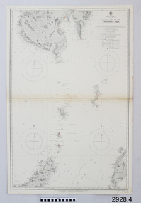 Flagstaff Hill Maritime Museum and Village
Document - Navigation Chart, Eastern Part of the Celebes Sea, Ca. 1928
This is an Official British Admiralty Navigation Chart, one of a set of 65 charts donated together with a wooden chart case. It was published and printed in London in 1928 by the British Admiralty. Navigation charts are drawn by professional hydrographers and describe the geography of land and water, enabling a water based navigator on board vessels such as ships to safely negotiate between ports locally and around the world. They are drawn to a particular standard with common symbols noting landmarks. The charts are used in conjunction with other navigational instruments and tools to calculate the vessel’s exact location and a safe route to its destination.The set of charts and their chart are of significance as examples of equipment and documents used to navigate the oceans of the world, particularly to Australia. Migration to Australia is an important part of this country's history.British Admiralty Navigation Chart - Eastern Part of the Celebes Sea - printed on rectangular white paper. Published in London by the British Admiralty in 1928.warrnambool, shipwreck coast, flagstaff hill, flagstaff hill maritime museum, flagstaff hill maritime village, chart, map, navigate, navigation, location, vessel, 1928, british admiralty, hydrographer, geography, admiralty chart, celebes sea -
 Mission to Seafarers Victoria
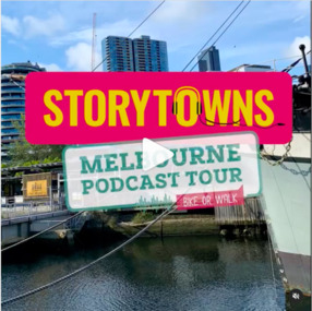
Document - Media release, Podcast reveals unique Melbourne experiences, April 2022
In April 2022, the City of Melbourne partnering Storytown, with launched the "Melbourne Podcast Tour". Storytown, an application created by Jarrod Pickford offering audio guides. This self-guided tour takes you along the Yarra River, from Southbank to Docklands, taking around 1.5 hours to complete by bike or 2 hours by foot. From their website: "Told by locals Discover Australia through the voices of its locals! Storytowns collaborates with communities to craft immersive audio guides, offering authentic travel tales from the heart of each neighborhood. Simply grab your headphones, download our app and explore Melbourne’s suburbs with with our fresh-out-the-oven “Railway Stories” audio guides! And if you’re feeling adventurous this weekend, take a road trip through regional Australia and let us jazz up your adventure, where the local folks are the true stars of the story. Sue Dight was interviewed to add to tThe interview was a to way to put the Mission to Seafarers on the map and increase its visitation. Unfortunately the tour is not avalaible anymore (as from 2023).Digital copy of a media releasecom, city of melbourne, app, storytown, sue dight, on the map, marketing, audioguide, jarrod pickford, audio guides, self-guides tour, podcast, radio interview -
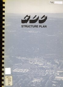 Greensborough Historical Society
Book - Planning Document, TTM Consulting Pty Ltd, Greensborough District Centre: Structure plan, 1989, 1989_07
A summary of investigations into impacts of the Greensborough District Centre in 1989, with plans for the development of the East side of Main Street Greensborough.91 pages text and black and white line drawings. One colour fold out map. Black plastic binding and clear plastic cover. greensborough district centre, main street greensborough, greensborough plaza -
 Greensborough Historical Society
Document, Parliament of Victoria, Ministers & Members search - the Hon. Colin Brooks (Bundoora), 23/04/2021
Biographical details of the Hon. Colin Brooks, MLA for Bundoora, taken from Parliament of Victoria - Ministers and Members website; and, map of the electoral district of Bundoora.2 p. text and colour photograph, with colour map of Bundoora Electoral Districtbrooks family, victoria parliament, colin brooks, bundoora -
 Mission to Seafarers Victoria
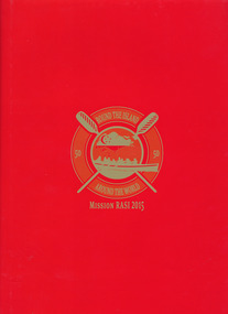
Book, Mission to Seafarers, Round the Island- Around the World - Mission RASI 2015, 2015
"In connection with the SG50 celebrations in Singapore, Mission RASI (Row Around Singapore Island) will see a team of Singaporeans join hands with friends from overseas in a test of endurance and teamwork, to raise funds to further the Mission's work in promoting good shipping practices and a safe working environment for seafarers"--Page 4.Red cardboard hard cover book with red paper outer sleeve. 55 pages : color illustrations, color map ; 31 cmnon-fiction"In connection with the SG50 celebrations in Singapore, Mission RASI (Row Around Singapore Island) will see a team of Singaporeans join hands with friends from overseas in a test of endurance and teamwork, to raise funds to further the Mission's work in promoting good shipping practices and a safe working environment for seafarers"--Page 4.mission to seafarers, worldwide, charity, volunteers, singapore, nigel porteous, andrea fleming, london, rasi, row around singapore island, 2015, fundraising, reverend andrew wright, mts london, mts singapore, rowing -
 Mission to Seafarers Victoria
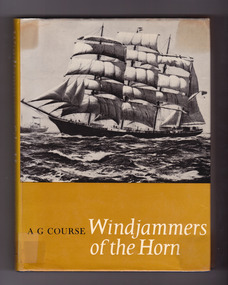
Book, Alfred George Course, Windjammers of the Horn: the story of the last British fleet of square-rigged sailing ships, 1969
From dust jacket: This is the unique story of the sailing ships owned by Sir William Garthwaite between 1915 and 1929, which formed in fact the last sailing merchant fleet to trade under the British flag. Captain A.G. Course, a Cape Horner himself, tells the story of this fleet whose vessels sailed so often past the awesome tip of South America, with a wealth of detail, happily marrying factual information and anecdote to produce a valuable historical record. Here are some of the last great characters of the age of sail, both men and ships, brought to life. The author's own close contact with the vessels and their crews allows him to capture the atmosphere most realistically. The Garthwaite ships, for all the effort put into their operation, were fighting a last-ditch stand against the inevitable supremacy of steam. It is with a certain nostalgia that the author records the passing of a fine fleet and documents an important chapter in maritime history.Navy blue cloth cover with embossed golden lettering on the spine, and mustard dust jacket illustrated by original painting by Commander DGM Gardner. xvi, 176 p. : 16 plates, illus., maps, ports. ; 22 cm. Includes index.non-fictionFrom dust jacket: This is the unique story of the sailing ships owned by Sir William Garthwaite between 1915 and 1929, which formed in fact the last sailing merchant fleet to trade under the British flag. Captain A.G. Course, a Cape Horner himself, tells the story of this fleet whose vessels sailed so often past the awesome tip of South America, with a wealth of detail, happily marrying factual information and anecdote to produce a valuable historical record. Here are some of the last great characters of the age of sail, both men and ships, brought to life. The author's own close contact with the vessels and their crews allows him to capture the atmosphere most realistically. The Garthwaite ships, for all the effort put into their operation, were fighting a last-ditch stand against the inevitable supremacy of steam. It is with a certain nostalgia that the author records the passing of a fine fleet and documents an important chapter in maritime history. windjammers, captains, martin frampton, catherine aviss (nee frampton), herbert aviss, elisabeth frampton, inverneill, garthneil, wray castle, garthwray, alfred george course, invercauld, invermay, carnmoney, garthforce, garthsnaid, garthgarry, garthpool, juteopolis, captain roberts, crew, cape horn, cape leeuwin, captain thomas atkinson, spanish flu, wwi -
 Mission to Seafarers Victoria
Map - Street Map, Port de Papeete Tahiti
Several items were given by a seafarer, Mr Nicholas Garlick (1926-2009) into the care of Father Brady who retired from St Pauls Cathedral, Melbourne in 2018. Father Brady later donated the collection of; objects, documents and an extensive collection of cruise ship menus (1937-end of 20thC) to the Mission via the intermediary William Hastie, volunteer at the Mission for Seafarers.Tourist map of the streets of Port de Papeete, Tahiti printed in greenish-grey ink on thin ochre coloured cardboard. Produced for Hertz rent a car (see media). port de papeete, tahiti, hertz, nick garlick, nicholas garlick, father brady, william hastie, ship engineer, sailors, seamen, seafarers -
 Mission to Seafarers Victoria
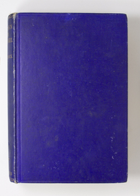
Book, Gollock, G. A. (Georgina Anne), 1861-1940, At the sign of the flying angel : a book of the sailor at the coastline, 1930
This book documents help and guidance provided by the Christian church to merchant seafarers as they traverse the world, particularly at their points of departure and arrival, and the interactions and activities that they are involved in at these ports.Medium--sized hardcover book of 244 pages. Cover of mid-blue colour, blank front and back covers, book title and author at top of spine in gold print. Book contains a number of illustrations and maps. London : Longmans, Green and Co., 1930 xi., 244 p., [16] leaves of plates : ill., maps, 2 ports. ; 20 cm. non-fictionThis book documents help and guidance provided by the Christian church to merchant seafarers as they traverse the world, particularly at their points of departure and arrival, and the interactions and activities that they are involved in at these ports.flying angel, reverend alfred gurney goldsmith, georgina anne gollock, ethel augusta godfrey 1861-1935, alice sibthorpe tracy -
 Phillip Island and District Historical Society Inc.
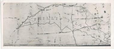
Photograph, Bryant West
... maps ...One of a collection of over 400 photographs in an album commenced in 1960 and presented to the Phillip Island & Westernport Historical Society by the Shire of Phillip IslandPhotograph of an early Map of Phillip Island not drawn to scale. Copy from Records Office, London.On back of photo - "If used must bear acknowedgement - reproduced by permission of the Hydrographer of the Navy" "Received 18/3/1955 from London Records Office per Mr mcGrigor-Phillips" Printed on Map "Phillip Island"local history, photography, photographs, maritime documents, maps, exploration, john jenner, bryant west, phillip island map -
 Greensborough Historical Society
Document - Document Collection, Local Council Representation Review, 2019_
Contents: 2 x Newspaper Clippings: Banyule City Council Electoral Representative Review, Heidelberg Leader 20/08/2019 and Diamond Valley Leader 21/08/2019. Local Council Representative Review Submission Guide. Victorian Electoral Commission, 2019. 24 p., text. General information for those making a submission to a review. Local Council Representative Review Preliminary Report: Banyule City Council. Victorian Electoral Commission, August 2019. 31 p., text and colour maps. Reports on submissions and gives 3 options for electoral review in Banyule. Local Council Representative Review: Banyule City Council 1. Public hearing agenda and attachments. 25/09/2019. 9 p. 2. Public hearing agenda and attachments. 25/09/2019. 2 p. Agenda and handwritten notes by R. Bray. Local Council Representative Review Final Report: Banyule City Council. Victorian Electoral Commission, October 2019. 46 p., text and colour map. Recommends increasing the number of councillors and wards to 9. 2 newspaper clippings, 3 booklets and agenda with attachments. Filed in black plastic folder.banyule city council, victorian electoral commission, local council representative review 2019 -
 Greensborough Historical Society
Document, BRAG submission to the VEC Representation Review, by Banyule Residents Action Group Inc, 2019_
This is a submission to the Victorian Electoral Commission, which periodically reviews electoral representation in municipal areas. The last review of Banyule City Council was in 2007.7 p. typescript with colour mapbanyule city council, brag banyule residents action group -
 Greensborough Historical Society
Article, Let's visit Bundoora, 1841o
This collection of notes aims 'for a deeper appreciation and understanding of the impact of our lives; culture and actions;.in Bundoora; a developing community'. Includes copies of uncited articles; photos and maps.Background information on Bundoora in the 20th century.Collection of articles, possibly notes from an oral presentation. Complete document available at GHS."Contents largely sourced from "In the beginning there was only the land", Len Kenna, 1988." - note on page 1.bundoora -
 Greensborough Historical Society
Folder, Hume Street Improvement Committee, 1958_
The Hume Street Improvement Committee was one of several 'progress associations' in the Greensborough area at the time the area was being urbanised. A typed page explains the concerns of residents when the street was being paved. Includes photographs and maps of area.These documents are concerned with the urbanisation of Greensborough in the mid 20th century while residents tried to maintain the rural feel of the area.Foolscap manilla folder containing various lists, maps and photographs.On cover "Hume Street Improvement Committee/ spare circulars/maps"greensborough, road making, brian roberts, hume street improvement committee, briar hill -
Glenelg Shire Council Cultural Collection
Document - Invitation - Maretimo Cocktail Party, n.d
-
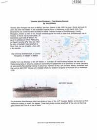
![Planning Document, Plan of proposed subdivision of land in Greensborough [Map shows Scotland house], 01/04/1971](/media/collectors/4f729f5697f83e03086015b8/items/5982a68921ea6b1420e4e560/item-media/59916fb521ea681094908d7a/item-fit-380x285.jpg) Greensborough Historical Society
Greensborough Historical SocietyPlanning Document, Plan of proposed subdivision of land in Greensborough [Map shows Scotland house], 01/04/1971
This subdivision of Greensborough shows the home of John Scotland (died 1888) and surrounding area bounded by Hailes, William, Lorimer, and Jessop Streets.Photocopy of plan, 2 pages.Part of plan (68G) of proposed subdivision of Greensborough, part of Crown Portion 18, Parish pf Keelbundora. Scale: 132 ft. to an inchjohn scotland, hailes street greensborough, william street greensborough, lorimer street greensborough, jessop street greensborough -
 Greensborough Historical Society
Document, John Gibson et al, Thomas John Finnigan - the missing gunner, 1914-1918
Article on the World War 1 service of Thomas Finnigan and the likelihood that he abandoned his wife and future child in Ireland when he took ship to Australia in 1915.6 p., colour images and mapthomas john finnigan, world war 1 project -
Glenelg Shire Council Cultural Collection
Document - Portland Town Directory, n.d
Portland Town Directory. Single sheet, printed both sides, folded 5 times. Illustration of Municipal Offices and old Town Hall on front - black and white. Directory contains map of Portland, street names, organisations, clubs etc. , emergency numbers -
Glenelg Shire Council Cultural Collection
Document - Portland and South West Tourist Guide, E. Davis & Sons, Pty Ltd Portland, n.d
Single page flyer, folded 3 times, printed both sides. White, black print, tourist guide to Portland and the far South West. Illustrations of Portland and district, maps of Portland, Heywood and Nelson, information about places to see. -
Glenelg Shire Council Cultural Collection
Document - Portland Tourism Brochure, National Parks Victoria, n.d
DL flyer, fold out map showing location of National Parks in Victoria with written description of each, plus photos of various flora and fauna, prefaced by brief history of national parks in Victoria. Full colour. -
 City of Moorabbin Historical Society (Operating the Box Cottage Museum)
Document, laminated photocopy of 'Plan of Moorabbin 1850', 1853
Weston Bate, 'A history of Brighton' 1962 informs us that in 1840 Henry Dendy, who was a farmer in Sussex England, paid 5,120 pounds sterling @ 1pound per acre for a 'Special Survey of Land in Port Phillip , Australia. Henry arrived in Australia in 1841 on the frigate 'York' with his wife, son, and three servants. He also took advantage of the Government Assistance of Free Immigrants for Survey Purchasers, to help on his estate and persuaded some Sussex men with their families to follow him. However when Dendy arrived in Port Phillip he found that LaTrobe and Gipps were trying to raise the price of land close to Town to 15pounds per acre. Dendy asked merchant J.B.Were to manage his affairs and they went ahead with plans to subdivide the surveyed land called 'The Brighton Estate' This area of land extended easterly from the Port Phillip Bay to East Boundary Road and from North Road to South Road in the Parish of Bourke Victoria. The Privy Council, England , decide that Henry Dendy could purchase the land at 1pound per acre. Land Sales proceeded from 1844 as more immigrants established market gardens, farms and varied businesses in 'Moorabbin'This is a photocopy of a Map of the Moorabbin , County of Bourke c1850 showing the 'Henry Dendy Special Survey 1841'A photocopy of a Map of the Moorabbin , County of Bourke c1850. A3 size laminatedLeft corner : MOORABBIN / COUNTY OF / BOURKEdendy henry, dendy special survey 1841, brighton, moorabbin, ormond, bentleigh, market gardeners, pioneers early settlers, box william, box elizabeth