Showing 1811 items matching "planning and development"
-
 Kew Historical Society Inc
Photograph - Flooding of the Yarra Valley at Kew, 1974
Flooding of the Yarra Valley, including that section of the Yarra bordering Kew and Kew East in the north and west of the municipality, was a regular occurrence. Extreme flood events of the Yarra River are recorded to have occurred in 1891, 1901, 1916, 1923 and 1934. The Municipality of Kew's response to these floods was to enact planning decisions restricting residential development in flood prone areas following the floods of 1916, 1921 and 1934. While floods continued after the development of the Upper Yarra Reservoir (construction 1948-57), the regularity and extent of these inundations diminished. During the nineteenth century, the land abutting the south side of the Yarra in Kew was devoted to dairy farming. In the twentieth century, before and after the construction of the Eastern Freeway, much of this low-lying area was used as golf courses and public parks.Late example of the capacity of the Yarra Valley at Kew to flood, even though drainage works and the Upper Yarra Reservoir had reduced their regularity.Original black and white print photograph of the low-lying land at East Kew under floodwater on 16 May 1974. The photograph is taken from 43 Kellett Grove.Annotation verso: "Kellett Gve No.43 / Flood Level / 16 May 1974 11.40am"floods, yarra river, kellett grove -
 Eltham District Historical Society Inc
Photograph, Liz Pidgeon, Heritage Excursion; The 1901 Eltham Railway Walk, 3 May 2014, 3 May 2014
Newsletter No. 216, May 2014 May Excursion – The 1901 Eltham Railway Walk The railway from Heidelberg to Eltham was opened in 1902. Over the previous year railway construction cut a curving swathe through Josiah Holloway’s 1851 Little Eltham subdivision. The survey plans for the railway show the owners and occupiers of land within Little Eltham affected by the railway alignment and for some distance each side. The plans show houses and other buildings but development at that time was rather sparse. Copies of these plans from the State Library of Victoria collection have been provided to the Society by Alan Sheehan. For our walk on 3rd May we intend to follow the railway from the Eltham Station to Ryans Road, which was the boundary of the adjoining Montmorency Farm. The return will be by way of nearby streets. Along the way we will discuss the details shown on the railway plans as well as more recent railway documents and photographs. At the conclusion and if time permits we can inspect the historical display at the Eltham Station. The walk is about 3 km in length and will take about 2.5 hours. It will start at 2 pm at the Eltham Railway Station car park (east/Main Road side) (Melway Ref. 21 J5).Born Digitalheritage excursion, activities, eltham district historical society, eltham railway station, eltham library, trestle bridge -
 Bendigo Historical Society Inc.
Drawing - NORMAN PENROSE COLLECTION: BROWN FOLDER, 1955
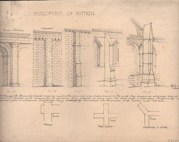
Artwork. Norman Penrose collection: large brown folder with wide black spine containing a page from Water Life with coloured sketches of the Murray Cod, the Azure Kingfisher and the Swamp-hen. A page from the Herald-Sun, Feb 13, 1955 with ladies shoes on one side and the third article of a series of Lawrence of Arabia on the other. Notes and drawings of Ionic Order (Erectheion - Athens. North Portice). And Doric Order (Temple of Theseus. Athens. 5th Cent BC). Also Corinthian Order (Choragic Monument of Lysicrates. Athens). Plan of the Parthenon. Notes on perspective. Notes and illustrations on the Development of Buttress.drawing, pencil, norman penrose collection, water life, notes on drawings, herald-sun, ionic order, corinthian order, doric order -
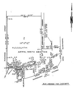
 Kew Historical Society Inc
Plan - Subdivision Plan, J R Mathers & McMillan, Myrtle Hill Estate, East Kew, circa 1949, c.1949
The Kew Historical Society's map collection includes a substantial number of real estate subdivision plans, mainly of Kew but also of surrounding suburbs in Melbourne. Most of the subdivision plans date from the 1920s and 1930s when the districts old homes and local farmland were being split up to accommodate residential growth in the postwar period. These early plans were assembled by a local firm, Jas R Mather & McMillan, which had an office in Cotham Road. Many of the plans, and sometimes photos, were annotated by the agents.Subdivision plans are historically important documents used as evidence for the growth of suburbs in Australia. They frequently provide information about when the land was sold as well as evidence relating to surveyors and real estate and financial agents. The numerous subdivision plans in the Kew Historical Society's collection represent working documents, ranging from the initial sketches made in planning a subdivision to printed plans on which auctioneers or agents listed the prices for which individual lots were sold. In a number of cases, the reverse of a subdivision plan in the collection includes a photograph of a house that was also for sale by the agent. These photographs provide significant heritage information relating house design and decoration, fencing and household gardens.The photograph may also be aesthetically significant depending on the importance of the photographic atelier.Myrtle Hill, at 14 Vista Avenue, Kew, is of local historical and architectural significance as a good example of a large and imposing single-storey Italianate house of the early 1870s surviving in Kew. Originally sited on a large allotment overlooking Normanby Road, the setting of the house has been dramatically altered through extensive subdivision and development. The subdivision plan of the ‘Myrtle Hill Estate’ indicates that in one such subdivision, 11 allotments were created fronting Bowyer Avenue, Myrtle Avenue, and Normanby Road. The outline and building profile of Myrtle Hill is shown on the west side of Bowyer Avenue.The full (typed) title of this subdivision plan is :"Plan of SUBDIVISION of part of CROWN PORTION 83. / at KEW / PARISH OF BOROONDARA. / COUNTY OF BOURKE". / "MYRTLE HILL ESTATE / EAST KEW" In addition to the Title and subtitle, the plan also lists the advantages of the subdivision. -
 Melbourne Tram Museum
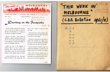
Magazine, City Development Association, "This week in Melbourne", 1961
Set of 24 magazines - each a folded foolscap sheet printed on semi gloss paper with a red printed heading, titled "This week in Melbourne", published by the City Development Association - 1961. Looks at issues that affect the Melbourne CBD, traffic, planning, MMBW, open space, population, parking, overseas practices, City of Melbourne, water supply, freight terminal. Published on a fortnightly basis. All contained loosely within a brown card folder with the title written on the front and issue numbers. 1961 issues are: 2-8, 10, 12-15, 18-21, 28-31, 33-36.Has AETA stamp on front cover with the letters "3CT with a running number alongside."trams, tramways, melbourne, city of melbourne, public transport, road transport, traffic control -
 Falls Creek Historical Society
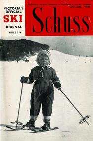
Journal - Schuss Vol. 24. No.8 November - December 1958
Schuss was advertised as Victoria’s Official Ski Journal It was issued monthly from 1935 to 1961 except during the war when summer issues covered two months. This continued after the war, but it averaged 10 issues annually over its 25 year life. Schuss was published by the Ski Club of Victoria which had a membership of 38 Ski Clubs and demanded to be recognised as the prime authority on skiing in the state. The other 30 ski clubs with 85% of the members disagreed and the politics of skiing became heated. These clubs formed the Federation of Victorian Ski Clubs with their own journal, Ski Horizon. With the establishment of the Victorian Ski Association, Ski-Horizon published its last issue in Nov - Dec. 1955 and the role of the official journal was fully taken over by “Schuss”. This item is significant because it contains stories, images and information documenting the development of the ski facilities at Falls Creek.The journal features stories and events chronicling developments in Victoria and internationally. The cover features an Eric Burt photo Dannielle Forras of Mount Buller, daughter of Ernest Forras. The photo is titled "The right age to start". Page 332 mentions Cecil Dobson and Orest Frueauf plans to open a new chalet "Winter Haven" for the next season. Page 333 includes a photo of the trophy presentation at the Falls Creek Junior Championship in September 1958. Page 345 features results from the Albury Ski Club Racing Carnival and the two Myrtleford results held on the same day.schuss journal, albury ski club carnival, myrtleford ski club, cecil dobson, orest frueauf, winterhaven ski lodge -
 Wodonga & District Historical Society Inc
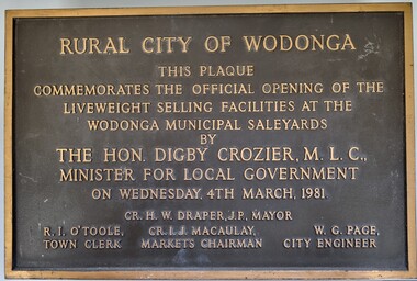
Plaque - Commemoration of the Opening of Liveweight Sales Wodonga Municipal Saleyards 1981
This plaque commemorates the official opening of the liveweight selling facilities at the Wodonga Municipal Saleyards, named the W. G. Page Saleyards, in 1980. Liveweight selling usually involves a curfew where cattle have to be at the saleyard by a specific time before the sale in order for them to be weighed prior to auction. Cattle that do not make the curfew time are sold on a $/head basis. The last sales at this facility took place in February 2015 before being replaced by the privately-run Barnawartha North's Northern Victoria Livestock Exchange. William George Page was Shire and City Engineer in Wodonga from 1965 until 1989. When he arrived the Shire of Wodonga had a population of 17,000 people. In 1966 Wodonga was selected as a city for special growth assistance. In 1972 Bill Page presented a new Town Plan to the Wodonga Council. Over the ensuing years he dedicated himself to bring this plan to fruition. He often had to argue and campaign with the Albury-Wodonga Corporation to push for the interests of development in Wodonga. This included winning a planning appeal to allow the saleyards to be relocated to Bandiana on the outskirts of Wodonga. Bill Page retired on health grounds in July 1989. The Council honoured him with a farewell dinner and renamed the saleyards at Bandiana the W.G. Page Saleyards in his honour.The Mayor , Cr Valentina Gillard, said "Every development in Wodonga in the past 24 years has a bit of Bill Page in it". William Page died 3 months later at 58 years old.A bronze forged metal plaque with detailed inscription. Bolts to fix plaque to the wall are still attached.RURAL CITY OF WODONGA / THIS PLAQUE/ COMMEMORATES THE OFFICIAL OPENING OF THE/ LIVEWEIGHT SELLING FACILITIES AT / THE WODONGA MUNICIPAL SALEYARDS /BY/THE HON. DIGBY CROZIER, M.L.C., / MINISTER FOR LOCAL GOVERNMENT/ ON WEDNESDAY, 4TH MARCH, 1981 CR. H. W, DRAPER, J.P. MAYOR R. I. O'TOOLE TOWN CLERK , CR. I. J. MACAULAY MARKETS CHAIRMAN W. G. PAGE CITY ENGINEERlivestock sales wodonga, liveweight cattle sales, municipal saleyards wondonga -
 Ringwood and District Historical Society
Document - Folder, Commercial and Retail Property Sales Information, Civic Place and Melbourne Street, Ringwood - 1998
45 photocopied pages including - Plan of Subdivision No.LP80718, Parish of Ringwood, Victoria, Crown Portion 12(Part) and part of a former government road Ref Vol 8668 Fol 745. - Vendors Statement, Planning Certificate and Heritage Council (Victoria) Certificate issued for 20 Melbourne Street, Ringwood. - Maroondah City Council Land Information Certificate for 149 149A and 149B Maroondah Highway; number 8 Civic Mall; and numbers 16, 20, 22 & 24 Melbourne Street Mall. - Yarra Valley Water statements relating to encumbrances for Shop 11, 149 Maroondah Highway; Shop 10, 149A Maroondah Highway; Shop 9, 149B Maroondah Highway; numer 8 Civic Place; Unit 3, 20 Melbourne Street; Office 4, 20 Melbourne Street; Shop 7, 22 Melbourne Street; and Shop 8, 24 Melbourne Street. - Land Tax Certificate pertaining to Commonwealth Bank, Civic Place, Ringwood. - Certificate of Title Vol 8892 Fol 906, Lot One on Plan of Subdivision No. 80718, Parish of Ringwood - Hanover Developments P/L - 29th June, 1971. -
 Eltham District Historical Society Inc
Photograph, Liz Pidgeon, Heritage Excursion; The 1901 Eltham Railway Walk, 3 May 2014, 3 May 2014
Football match at Eltham Central Park between Eltham and Heidelberg Newsletter No. 216, May 2014 May Excursion – The 1901 Eltham Railway Walk The railway from Heidelberg to Eltham was opened in 1902. Over the previous year railway construction cut a curving swathe through Josiah Holloway’s 1851 Little Eltham subdivision. The survey plans for the railway show the owners and occupiers of land within Little Eltham affected by the railway alignment and for some distance each side. The plans show houses and other buildings but development at that time was rather sparse. Copies of these plans from the State Library of Victoria collection have been provided to the Society by Alan Sheehan. For our walk on 3rd May we intend to follow the railway from the Eltham Station to Ryans Road, which was the boundary of the adjoining Montmorency Farm. The return will be by way of nearby streets. Along the way we will discuss the details shown on the railway plans as well as more recent railway documents and photographs. At the conclusion and if time permits we can inspect the historical display at the Eltham Station. The walk is about 3 km in length and will take about 2.5 hours. It will start at 2 pm at the Eltham Railway Station car park (east/Main Road side) (Melway Ref. 21 J5).Born Digitalheritage excursion, activities, eltham district historical society, eltham railway station, eltham library, trestle bridge, eltham central park, football -
 Eltham District Historical Society Inc
Photograph, Liz Pidgeon, Heritage Excursion; The 1901 Eltham Railway Walk, 3 May 2014, 3 May 2014
EDHS Member Doug Orford stands by a yarn bombing installation. ewsletter No. 216, May 2014 May Excursion – The 1901 Eltham Railway Walk The railway from Heidelberg to Eltham was opened in 1902. Over the previous year railway construction cut a curving swathe through Josiah Holloway’s 1851 Little Eltham subdivision. The survey plans for the railway show the owners and occupiers of land within Little Eltham affected by the railway alignment and for some distance each side. The plans show houses and other buildings but development at that time was rather sparse. Copies of these plans from the State Library of Victoria collection have been provided to the Society by Alan Sheehan. For our walk on 3rd May we intend to follow the railway from the Eltham Station to Ryans Road, which was the boundary of the adjoining Montmorency Farm. The return will be by way of nearby streets. Along the way we will discuss the details shown on the railway plans as well as more recent railway documents and photographs. At the conclusion and if time permits we can inspect the historical display at the Eltham Station. The walk is about 3 km in length and will take about 2.5 hours. It will start at 2 pm at the Eltham Railway Station car park (east/Main Road side) (Melway Ref. 21 J5).Born Digitalheritage excursion, activities, eltham district historical society, eltham railway station, eltham library, trestle bridge, yarn bombing, doug orford -
 Eltham District Historical Society Inc
Document - Folder, Jim Connor et al, Eltham Gateway, 1987
The Eltham Gateway Group (EGG) was established about 1987 by some Eltham residents concerned for the development of the Eltham Gateway, defined as that historically and environmentally sensitive region of land along Main Road, Eltham extending from the roundabout at Fitzsimons Lane to Dudley Street, Eltham. The gateway was a unique urban area with a strong sense of character that provided a distinctive entrance to the Eltham Town Centre. The intention of this group was to support development that preserved both the natural and historic features of the gateway region. It encouraged development sympathetic to Eltham’s traditional association with the arts and natural environment. The group was initiated in response to a planning application in December 1986 to redevelop the then Mobil service station site at 729 Main Road, Eltham on the corner of Brougham Street. This group worked with and encouraged the Eltham Shire Council to consider rezoning to protect the gateway area. A detailed Eltham Gateway Study undertaken by Tract Consultants assisted with the establishment of the Eltham Gateway Zone, the Eltham Gateway Policy and the Eltham Gateway Design and Siting Guidelines. The State Government subsequently agreed to a planning amendment to rezone the land from a Residential Zone C to an Eltham Gateway Zone under the Eltham Planning Scheme. While zoning changes over the years have altered the mix of permitted uses within this area the Eltham Gateway still looks and feels like a predominately residential style precinct, even where non-residential type uses operate. EGG was followed by the establishment of the Eltham Protection Society in about 1989 to respond to community planning issues beyond the area of the Eltham Gateway and in effect took over the role from the EGG. Jim Connor President Eltham District Historical Society 4 July 2022 During 1986/87 I was a community member on the Shire of Eltham’s Community Consultative Committee involved with the Eltham Gateway Study, which led to the establishment of the original Eltham Gateway Zone, under the then Eltham Planning Scheme The Eltham Gateway Group was the pioneer community action group dedicated to protecting the character of the Eltham Gateway. It was succeeded by the Eltham Protection Society. When the Shire of Eltham Offices were demolished by the unelected Commissioners of Nillumbik Shire Council in July/August 1996, significant community upset and protest led to the establishement of the Eltham Gateway Action Group (EGAG) which in present day form has evolved into the Eltham Community Action Group (ECAG) focussing on issues throughout Eltham and not just the Eltham Gatewayeltham community action group, eltham gateway, eltham gateway action group, eltham gateway design and siting guidelines, eltham gateway group (egg), eltham gateway policy, eltham gateway study, eltham gateway zone, eltham planning scheme, eltham protection society, jim connor, michael wilson, rodger dalling, tony mcmanus -
 Eltham District Historical Society Inc
Document - Sales Brochure, Dallas Price Homes Pty Ltd, Eltham Hub: A Unique New Entry To Eltham's Town Centre; the facts about this multi purpose development, 1996
Produced by Contour Consultants Australia Pty Ltd on behalf of Dallas Price Homes Pty Ltd as part of the planning process for redevelopment of the former Eltham Shire Office site at 895 Main Road. In 1963 the Shire of Eltham purchased the Shillinglaw property of approximately 2 acres in Main Road, Eltham for the widening of Main Road and as a site for new Council offices. This land, which contained the Shillinglaw Cottage (c1878-80), was the remaining section of the Shillinglaw family holding that originally comprised 30 acres, being Lot 90 of Holloway's 1851 subdivision. Eltham Council intended to demolish this cottage, but through extensive community action it was saved, funds were raised, and it was relocated to the current site adjacent to the Eltham Library. The new Eltham Shire Offices opened in 1965 were designed to ensure retention of the three Italian Cypress trees that were located outside the Shillinglaw Cottage. In 1971 the building was extended at the southern end to provide additional space, including for the Eltham Library and Council's Engineering Department. Renovations were undertaken to the offices during 1987. The Victorian State Government commenced to restructure local government in 1994, which resulted in the establishment of the Shire of Nillumbik and the cessation of the Shire of Eltham. This new Nillumbik Shire Council was headed by government appointed commissioners, who decided in 1995 to put the former Eltham Shire offices on the market. Eventually in June 1996 the property was sold for $1.1 million and the building was subsequently demolished. A planning application for the site was then submitted to Nillumbik Shire Council in September 1996 for construction of a 24-hour service station, convenience store, cafe/takeaway food premises, a retail facility and community facility. There were many objections to this proposed development and in controversial circumstances a planning permit was granted by the Nillumbik Shire Council commissioners. After protracted actions involving a planning panel and a planning advisory committee, established by the Minister for Local Government, the proposal was eventually rejected as not satisfying the requirements of the planning scheme. In December 1997 the purchaser withdrew from the contract of sale, just prior to Council announcing a withdrawal from the contract. While there have been a number of possible development proposals considered by subsequent Nillumbik Shire Councils, this site has remained vacant since July 1996. TIMELINE (Prepared by Jim Connor, Eltham District Historical Society- March 2018- Based on press, council and personal records) June 1996 - Eltham Shire offices sold to Dallas Price Homes for $1.1 million. July 1996 - Shire office building demolished against community's wishes. Council claimed building riddled with asbestos. September 1996 - Planning application submitted to Nillumbik Shire Council to construct on the site a 24 hours Shell service station, convenience store, Hungry Jacks café/takeaway food premises, a retail facility and community facility. 213 objections and petition of over 1400 signatures received. Minister for Planning and Local Government orders an independent investigation into valuation and sale. 9 October 1996 - Permit granted by Nillumbik Shire Council commissioners, in controversial circumstances. A Planning Special Committee consisting of 3 commissioners and 3 community representatives considered 32 community objections. One commissioner declared a potential conflict of interest so only 2 commissioners were able to vote. After hearing all objections, the community representatives moved a foreshadowed motion to refuse a permit. The commissioners then closed the meeting, formerly opened a council meeting (for about a minute) and approved the application. October 1996 - Community members appealed planning decision to Administrative Appeals Tribunal. November 1996 -Minister for Planning and Local Government Robert McClelland calls appeal in and directs MT to refer this 'major policy issue' to the Governor in Council. February 1997 - Planning panel (Dimity Reed and Margaret Pitt) established to consider submissions. March 1997 - New council elected with five councillors. April 1997 - Three of the five new councillors vote to fight Commissioner's decision to grant a permit. April 1997 - Planning panel (Dimity Reed and Margaret Pitt) conducts hearings at Nillumbik Shire offices. June 1997 -Planning panel rejected Dallas Price Homes proposal as being 'totally inappropriate' for the site and recommends the site be rezoned for 'public purposes'. July 1997 - Dallas Price Homes threatened to sue Council and individual councillors. October 1997 - Report released of an Advisory Committee (Paul Jerome) established by the Minister for Planning and Local Government. Committee considered Dallas Price Homes proposal and an alternative concept plan proposal by Council for a gallery, workshop, offices and cinema community-based development. Advisory Committee recommended Dallas Price Homes proposal be rejected as not satisfying the requirements of the planning scheme and recommended further testing of the financial viability of Council's proposal. December 1997 - Dallas Price Homes withdrew from the contract of sale, just prior to Council announcing a withdrawal from the contract, which expired on 28th November and was not renewed by either side, after previously being extended twice pending a decision by the Minister. Council had to pay developer $58,000 for demolition costs. February 1998 - Dallas Price Homes application rejected by Planning and Local Government Minister. October 1998 - Nillumbik Councillors suspended and an Administrator appointed (until March 1999). The demolition of the former Shire of Eltham offices and proposed sale and development driven by the Commissioners for Nillumbik Shire Council brought the community together in substantial protest at the infrigement of ratepayers democratic say in local government and ciommunity assets combined with protests about inappropraite development of Eltham's Gateway. This issue led to the formation of the Eltham Community Action Group which still operates strongly today (2023) on behalf of the community to ensure appropriate development within the community.895 main road, commissioners, dallas price homes, development application, eltham hub, hungry jacks, nillumbik shire council, re-zoning, shell service station, town planning, eltham gateway, eltham gateway action group, eltham shire offices, shillinglaw cottage, shillinglaw farm, shillinglaw trees, jim connor collection