Showing 25577 items matching "plenty-township-estate"
-
 City of Kingston
Pamphlet - Colour, Farrow Falcon Press, Printers, Ozone Estate, Bluff Road, Hampton, c.1940
Sales plan for land in the suburb of Hampton (Highett), bounded by Bluff Road, Wickham Road, Peterson Street and June Street. Includes Morley Street, Follett Avenue, and Parrett StreetThe developing urban area of Highett within the City of Kingston. This land sale pamphlet illustrates the subdivision of land within the municipality and the changing demographic of the district as new houses are constructed close to infrastructure.Colour pamphlet advertising for private sale the Ozone Estate, Bluff Road Hampton. Incorporates a map of the estate bordered by Bluff Road, Wickham Road, June Street and Peterson Street including Morley Street, Follett Avenue and Parrett Street.Handwritten in grey pencil on reverse: Ozone Printed in purple ink on front top right-hand corner: Vendors are - Leslie Harcourt MacGowan, Esq / Neerim Road, Caulfield / & / Arthur Alfred Parrett, Esq / 311 Flinders Lane / Melbourneland sales, estate, hampton, highett -
 Greensborough Historical Society
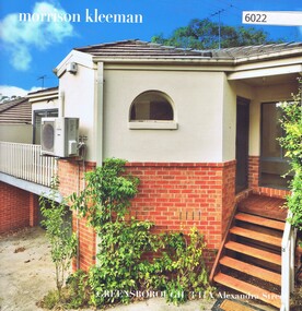
Advertising Leaflet, 3/11A Alexandra Street Greensborough, 2018_04
3/11A Alexandra Street Greensborough, 3 bedroom town house, sold April 2018 for $501,000. Previous sales: January 2005 $232,000 and October 1998 $173,000.Real Estate advertising leaflet,1 sheet folded into 4 pages, printed in colour both sides.alexandra street greensborough -
 Greensborough Historical Society
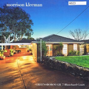
Advertising Leaflet, 7 Blanchard Court Greensborough, 05/02/2018
7 Blanchard Court Greensborough, 4 bedroom house, sold 05/02/2018 for $860,000. Previous sales: February 2008 $412,000 and March 1995 $155,000.Real Estate advertising leaflet,1 sheet folded into 4 pages, printed in colour both sides.blanchard court greensborough -
 Greensborough Historical Society
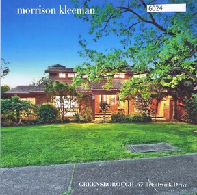
Advertising Leaflet, 47 Brentwick Drive Greensborough, 22/01/2018
47 Brentwick Drive Greensborough, 4 bedroom house, sold 22/01/2018 for $920,000. Previous sales: June 1987 $35,000 and October 1986 $30,000.Real Estate advertising leaflet,1 sheet folded into 4 pages, printed in colour both sides.brentwick drive greensborough -
 Greensborough Historical Society
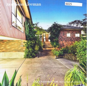
Advertising Leaflet, 56 Corowa Crescent Greensborough, 11/05/2018
56 Corowa Crescent Greensborough, 4 bedroom house, sold 11/05/2018 for $950,000. Previous sales: November 1987 $148,000, September 1984 $120,000, December 1982 $89,500 and March 1979 $14,100.Real Estate advertising leaflet,1 sheet folded into 4 pages, printed in colour both sides.corowa crescent greensborough -
 Greensborough Historical Society
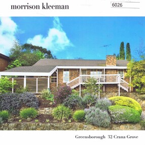
Advertising Leaflet, 32 Crana Grove Greensborough, 22/12/2016
32 Crana Grove Greensborough, 3 bedroom house, sold December 2016 for $635,500. Previous sales: June 2000 $184,000.Real Estate advertising leaflet,1 sheet folded into 4 pages, printed in colour both sides.crana grove greensborough -
 Greensborough Historical Society
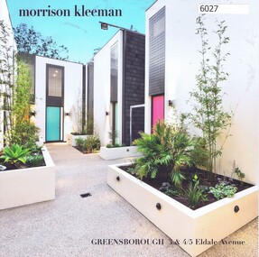
Advertising Leaflet, 3 & 4/5 Eldale Avenue Greensborough, 14/03/2018
3/5 Eldale Avenue Greensborough, 2 bedroom town house, sold March 2018 for $595,000. Previous sales: June 2000 $184,000. 4/5 Eldale Avenue sold February 2018 for $610,000Real Estate advertising leaflet,1 sheet folded into 4 pages, printed in colour both sides.eldale avenue greensborough -
 Greensborough Historical Society
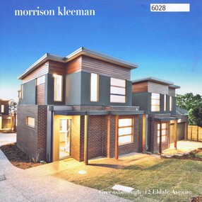
Advertising Leaflet, 12 Eldale Avenue Greensborough, 28/02/2017
12 Eldale Avenue Greensborough, group of 3 bedroom town houses. Unit 1 sold 28/02/2017 for $620,000. Unit 2 sold November 2016 for $595,000, Unit 3 sold November 2016 for $590,000, Unit 4 sold January 2017 for $730,000 and Unit 5 sold December 2016 for $630,000.Real Estate advertising leaflet,1 sheet folded into 6 pages, printed in colour both sides.eldale avenue greensborough -
 Greensborough Historical Society
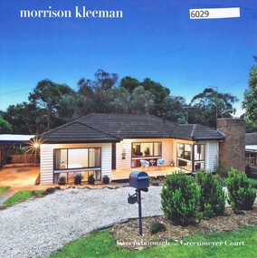
Advertising Leaflet, 7 Greenmeyer Court Greensborough, 20/05/2018
7 Greenmeyer Court Greensborough, 4 bedroom house sold 20/05/2018 for $965,000. Previous sales: October 2015 for $550,000.Real Estate advertising leaflet,1 sheet folded into 4 pages, printed in colour both sides.greenmeyer court greensborough -
 Greensborough Historical Society
Advertising Leaflet, 1/184 Grimshaw Street Greensborough, 16/10/2017
1/184 Grimshaw Street Greensborough, 2 bedroom house sold 16/10/2017 for $626,000. Previous sales: July 2016 for $555,000, May 2010 for $350,000 and March 2003 for $218,000.Real Estate advertising leaflet,1 sheet folded into 4 pages, printed in colour both sides.grimshaw street greensborough -
 Greensborough Historical Society
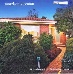
Advertising Leaflet, 4/139 Grimshaw Street Greensborough, 15/08/2018
4/139 Grimshaw Street Greensborough, 2 bedroom house sold August 2018 for $540,000. Previous sales: October 2002 for $235,000.Real Estate advertising leaflet,1 sheet folded into 4 pages, printed in colour both sides.grimshaw street greensborough -
 Greensborough Historical Society
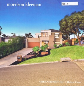
Advertising Leaflet, 5 Hakea Close Greensborough, 20/04/2018
5 Hakea Close Greensborough, 4 bedroom house sold April 2018 for $1,275,000. Built 2011. Previous sales: December 2005 for $299,000.Real Estate advertising leaflet,1 sheet folded into 4 pages, printed in colour both sides.hakea close greensborough -
 Greensborough Historical Society
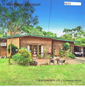
Advertising Leaflet, 11 Hebden Street Greensborough, 22/05/2017
11 Hebden Street Greensborough, 3 bedroom house sold March 2017 for $706,000. Previous sales: July 1990 for $110,000 and December 1975 for $27,000.Real Estate advertising leaflet,1 sheet folded into 4 pages, printed in colour both sides.hebden street greensborough -
 Greensborough Historical Society
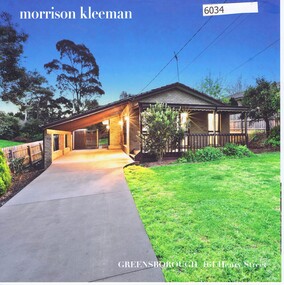
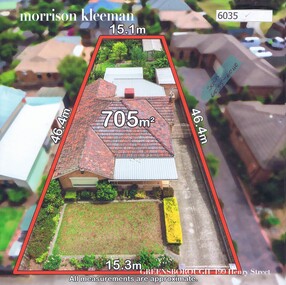
Advertising Leaflet, 161 Henry Street Greensborough, 17/11/2017
161 Henry Street Greensborough. 3 bedroom house October 2017 for $740,000. Previous sales: May 2012 for $450,000 and November 2005 for $268,000.Real Estate advertising leaflet,1 sheet folded into 4 pages, printed in colour both sides.henry street greensborough -
 Greensborough Historical Society
Advertising Leaflet, 199 Henry Street Greensborough, 18/05/2018
199 Henry Street Greensborough. 2 bedroom house. February 2018 for $930,000. Real Estate advertising leaflet,1 sheet folded into 4 pages, printed in colour both sides.henry street greensborough -
 Greensborough Historical Society
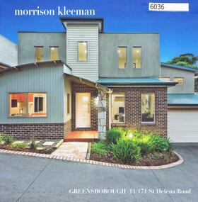
Advertising Leaflet, 11/171 St Helena Road Greensborough, 17/05/2018
11/171 St Helena Road Greensborough. 3 bedroom town house. Sold May 2018 for $750,000. Previous sales: July 2009 for $410,000.Real Estate advertising leaflet,1 sheet folded into 4 pages, printed in colour both sides.st helena road greensborough -
 Greensborough Historical Society
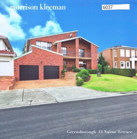
Advertising Leaflet, 14 Nairne Terrace Greensborough, 29/06/2018
14 Nairne Terrace Greensborough. 5 bedroom house. Sold May 2018 for $1,170,000. Previous sales: January 2014 for $700,000, October 2001 for $401,000, June 1991 for $280,000, February 1989 for $275,000 and March 1986 for $52,220.Real Estate advertising leaflet,1 sheet folded into 4 pages, printed in colour both sides.nairne terrace greensborough -
 Greensborough Historical Society
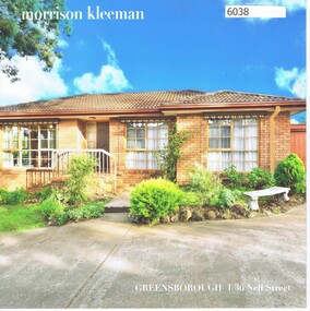
Advertising Leaflet, 1/36 Nell Street Greensborough, 29/07/2017
1/36 Nell Street Greensborough. 2 bedroom unit. Sold July 2017 for $590,000. Previous sales: January 1997 for $124,000, and September 1985 for $81,900.Real Estate advertising leaflet,1 sheet folded into 4 pages, printed in colour both sides.nell street greensborough -
 Greensborough Historical Society
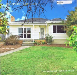
Advertising Leaflet, 128 Nell Street Greensborough, 28/05/2018
128 Nell Street Greensborough. 3 bedroom unit. Sold May 2018 for $860,000. Previous sales: November 2005 for $298,000.Real Estate advertising leaflet,1 sheet folded into 4 pages, printed in colour both sides.nell street greensborough -
 Greensborough Historical Society
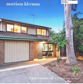
Advertising Leaflet, 6/12 Parkview Avenue Greensborough, 31/01/2018
6/12 Parkview Avenue Greensborough. 2 bedroom unit. Sold December 2017 for $585,000. Previous sales: December 2006 for $215,000.Real Estate advertising leaflet,1 sheet folded into 4 pages, printed in colour both sides.parkview avenue greensborough -
 Greensborough Historical Society
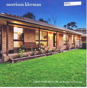
Advertising Leaflet, 14 Punkerri Circuit Greensborough, 06/04/2018
14 Punkerri Circuit Greensborough. 3 bedroom house. January 2018 for $845,000. Previous sales: September 2009 for $445,000, December 1999 for $210,000, May 1991 for $145,000 and March 1978 for $20,000.Real Estate advertising leaflet,1 sheet folded into 4 pages, printed in colour both sides.punkerri circuit -
 Greensborough Historical Society
Advertising Leaflet, 7 Ruby Lane Greensborough, 29/03/2018
7 Ruby Lane Greensborough. 3 bedroom town house. February 2018 for $549,000. Previous sales: May 2010 for $405,000, and August 2003 for $120,000.Real Estate advertising leaflet,1 sheet folded into 4 pages, printed in colour both sides.ruby lane greensborough -
 Greensborough Historical Society
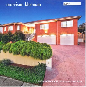
Advertising Leaflet, 20 Sugar Gum Boulevard Greensborough, 05/09/2017
20 Sugar Gum Boulevard Greensborough. 4 bedroom house. October 2017 for $1,210,000. Previous sales: September 2005 for $325,000.Real Estate advertising leaflet,1 sheet folded into 4 pages, printed in colour both sides.sugar gum boulevard greensborough -
 Greensborough Historical Society
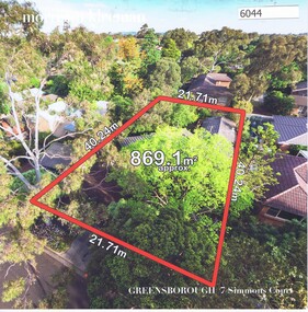
Advertising Leaflet, 7 Simmons Court Greensborough, 17/04/2018
7 Simmons Court Greensborough. 3 bedroom house. Sold December 2017 for $876,000. Real Estate advertising leaflet,1 sheet folded into 4 pages, printed in colour both sides.simmons court greensborough -
 Greensborough Historical Society
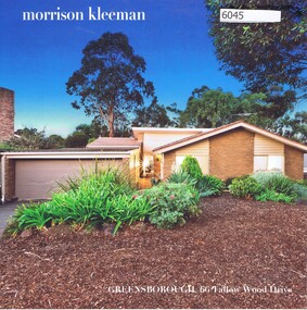
Advertising Leaflet, 66 Tallow Wood Drive Greensborough, 06/06/2017
66 Tallow Wood Drive Greensborough. 3 bedroom house. Sold May 2017 for $857,000. Previous sales: February 1992 for $147,000 and June 1980 for $46,000. Built 1985.Real Estate advertising leaflet,1 sheet folded into 4 pages, printed in colour both sides.tallow wood drive greensborough -
 Greensborough Historical Society
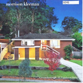
Advertising Leaflet, 14 Tamboon Drive St. Helena, 27/06/2018
14 Tamboon Drive St. Helena. 4 bedroom house. Sold June 2018 for $820,000. Previous sales: April 1977 for $19,650. Built 1980.Real Estate advertising leaflet,1 sheet folded into 4 pages, printed in colour both sides.tamboon drive greensborough -
 Greensborough Historical Society
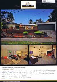
Advertising Leaflet, 1A Gilmour Court Greensborough, 21/12/2012
1A Gilmour Court Greensborough, 4 bedroom brick veneer home, auctioned 21 December 2012, sold $487,501Real estate advertising leaflet, 1 sheet, printed in colour one side, black and white on reverse.gilmour court greensborough -
 Greensborough Historical Society
Photograph - Digital image, Marilyn Smith, Plenty River bank at Greensborough 2015; Rear of lower Main Street shops, 16/08/2015
Vegetation on the Plenty River embankment in Greensborough. A River bank stabilisation project along the Plenty River at Greensborough was conducted by Melbourne Water in 2015.Digital copy of colour photographplenty river, melbourne water -
 Greensborough Historical Society
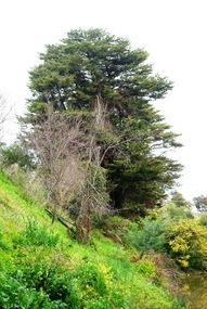
Photograph - Digital image, Marilyn Smith, Plenty River bank at Greensborough 2015; Trees, 16/08/2015
Tree on bank of Plenty River in Greensborough. A River bank stabilisation project along the Plenty River at Greensborough was conducted by Melbourne Water in 2015.Digital copy of colour photographplenty river, melbourne water -
 City of Moorabbin Historical Society (Operating the Box Cottage Museum)
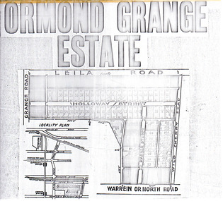
Flyer - Ormond Grange Estate, Ormond, 1913
At the end of World War One, there was a renewed interest in residential land and a number of estates opened up in the Municipality of Moorabbin.Example of the progress of the Municipality of MoorabbinPhoto copy of advertising flyer for auction of real estate sales - plan of building blocks for saleOrmond Grange Estateholloway street, wild cherry road, parker street, ormond, land sales, real estate