Showing 3226 items
matching road maps
-
 Glenelg Shire Council Cultural Collection
Map - Map - RACV Portland District Map, Portland, Victoria & Mt Gambier, South Australia, c. 1970
... Cliff Street Portland great-ocean-road RACV map, black and white ...RACV map, black and white tri-fold, photo of Cape Nelson lighthouse on front. When unfolded, map of Portland District on one side, map of Portland and Mt. Gambier on the other, together, with short description and a list of points of interest -
Glenelg Shire Council Cultural Collection
Administrative record - Annual Report - Portland Harbour Trust, 1972, c. 1972
Twenty-first Annual Report, Portland Harbour Trust for year ending 30 June 1972. Heavy card covers, glossy, brown, aqua, white, map of Victoriaportland harbour trust, annual report, administrative record -
Glenelg Shire Council Cultural Collection
Programme - Programme - 1951 Centenary and Jubilee Train program, c. 1951
The 1951 Centenary and Jubilee Train program. Trifold, white with royal blue print, maps; image of train, royal blue, green and yellow. Blue monochrome images of the first House of Legislature, November 13 1851, and the opening of the first Commonwealth Parliament, Melbourne Exhibition Building , May 9, 1901.centenary, celebration, 1951, train, travel -
Glenelg Shire Council Cultural Collection
Map - Map - scenic tours of Portland, n.d
... Cliff Street Portland great-ocean-road map tourism Portland ...Map - scenic tours guide of Portland and District (Portland Camera Club)map, tourism, portland camera club, travel -
Glenelg Shire Council Cultural Collection
Photograph - Photograph - Maritime Discovery Centre Gift Shop, c. 1998
Coloured photograph: inside Maritime Discovery Center, gift shop on left, young man standing in front of the information board about Great South West, map of Glenelg Shire on right. -
Glenelg Shire Council Cultural Collection
Map - Map - Portland, Victoria, n.d
... Cliff Street Portland great-ocean-road Map of Portland, produced ...Map of Portland, produced as an advertising medium by Portland Chicken Inn. Green card, dark blue print. Image of Portland Harbour on front, street index on back, open to Portland map, Chicken Inn marked on map. -
Glenelg Shire Council Cultural Collection
Pamphlet - Pamphlet - What's on in Portland, n.d
'What's on in Portland, tourist guide, doesn't have the map of Portland, as in 8197 a,b, and 8198, instead has advertising, also no mention of 'Back to Portland'. Front and back cover blue with black print, inside pale lemon, black print. -
Glenelg Shire Council Cultural Collection
Booklet - Booklet - South Western Victoria, n.d
Forty-two page tourist brochure of South Western Victoria, produced by Victorian Railways. Contains black and white photos of cities and towns in the south west with a short description of each. Centre page full colour map of area. Blue cover, red print, image of man in bathers on a beach.Front: 'B.W. Vivian', ink, faded -
Glenelg Shire Council Cultural Collection
Map - Fold-out fire control map - Region 4 Victoria, n.d
Fold-out fire control map for Region 4 - Victoria Northern sheet, includes numerical and alphabetical index. -
Glenelg Shire Council Cultural Collection
Map - Map - Western Victoria, n.d
... Cliff Street Portland great-ocean-road map western victoria ...Fold-out map of the western section of Victoria- Melbourne to Mt. Gambier and north to NSW border. Has been detached from its cover and glued to brown paper.map, western victoria, melbourne, mount gambier, victoria, south australia -
Glenelg Shire Council Cultural Collection
Flyer - Flyer - Portland, Victoria, Oct-38
Single page flyer, folded 4 times. Tourist information for Portland, issued by Publicity and Tourist Services, Victorian Railways. Contains several black and white photos of Portland, front cover red print, blue stylised bird and sea. Back cover has tourist map of Portland and District -
Glenelg Shire Council Cultural Collection
Medal - Medal - Syd Cuffe, Town Crier, c. 1995
Medal, copper, shaped like globe with banner, with star at each end, bell in centre, surrounding map of Australia. Bottom section of bell, including clapper, form part of shape of medal. Attached to green and gold ribbon.Front: '6th World Town Crier Championships Ballarat '95 ' -
Glenelg Shire Council Cultural Collection
Medal - Medal - Australian Bicentenary, 1988
Cupro-nickel medal commissioned by the Commonwealth of Australia to commemorate the Australian Bicentenary in 1988, designed by Michael Meszaros and M. Tracey and minted by the Royal Australian Mint in Canberra. This medal was presented to school children to commemorate the Australian Bicentenary in 1988. The obverse was designed by Melbourne artist Michael Meszaros and depicts school children climbing steps with the Southern Cross in the sky and the word 'EDUCATION' below. The reverse, designed by M. Tracey, features the Bicentennial logo, a map of Australia formed by intersecting diagonal lines.bicentennial, education, medal -
Glenelg Shire Council Cultural Collection
Flyer - Flyer - Princess Margaret Rose Caves, c. 2009
Princess Margaret Rose Cave 'flyer'. Light card, photo of cave formations on front, information about region, plus map, on reverse.advertising, tourism, travel -
Glenelg Shire Council Cultural Collection
Map - Map - Bridgewater Lakes Tour, 1970s
... Cliff Street Portland great-ocean-road map tourism travel ...Typed up directions around the Bridgewater area. Inside: Map of Portland - Bridgewater area.map, tourism, travel, recreation, cape bridgewater -
Glenelg Shire Council Cultural Collection
Pamphlet - Pamphlet - Tourist Guide to Portland, n.d
Twelve page tourist guide to Portland, includes map of Portland on middle pages, showing location of historic buildings, tourist office. Guide contains list of historic buildings, suggested tours, picnic areas, advertising. White with black print. -
Glenelg Shire Council Cultural Collection
Map - Map - Historic Buildings, Portland, 1970s
Camperdown and District Heritage Society collectionBlack and white pamphlet. Inside map of Portland showing location of historical buildings.map, historic buildings, portland -
Glenelg Shire Council Cultural Collection
Map - Map - Glenelg River, 1975
Laminated map, Glenelg River - Casterton, proposed flood level and lines to be designated. Photograph of map taken in 1975. Produced by Rural Water Commission to Shire Engineer, Casterton, attached to reverse of map.flood, flood levels, casterton -
Glenelg Shire Council Cultural Collection
Pamphlet, Historic Portland Buildings Open Day, 1970s
Camperdown and District Heritage Society, Collection.Two copies of black and white pamphlet to commemorate the first permanent settlement in Victoria, Historic Portland Buildings Open Day.Front: Black and white image of Gardens cottage Back: Black and white map of Historic Portland buildingshistoric buildings, buildings of portland, tourism, local history -
Glenelg Shire Council Cultural Collection
Plan - Plan - Map Portland Harbour, n.d
Port of Portland Authority Archivesport of portland archives, portland harbour -
Glenelg Shire Council Cultural Collection
Archive - Videotape, Greg Hutchins and Robert Downes, Portland's 150th Anniversary, 1984
Glenelg Shire CouncilFront: Videotape 'PORTLAND'S 150TH ANNIVERSARY OFFICIAL VIDEO TAPE , 1 HOUR' Back: Case 'PORTLAND DEVELOPMENT COMMITTEE COPY' - blue biro -
Glenelg Shire Council Cultural Collection
Plan - Town Plan - Cape Bridgewater, 02/04/1992
Black and white photocopy of an old plan of a subdivision at Cape Bridgewater. Two halves joined together with sellotape. Black texta numbers on some of the lots 1 - 28Front: 'OLD MAP' handwritten, top edgeplan, town planning, cape bridgewater -
 Glenelg Shire Council Cultural Collection
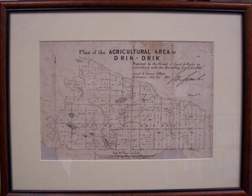
Map - Map of Drik-Drik, 1865
Displayed at History House.Print of map pasted onto board, mounted and framed under glass. Buff-coloured mount. Mahogany stained moulded wood frame, black inner frame.Front: Plan of the Agricultural Area of Drik-Drik L.2556/Prepared by the Board of Lands and Works in accordance with the "Amending Land Act 1865". Lands and Survey Office, Melbourne 11th May 1865. (printed, upper centre). Back: Duncan Hedditchmap, drik drik, plan, geography, cartography -
Glenelg Shire Council Cultural Collection
Booklet - Pamphlet - Promotional material Major Mitchell Cairn Reserve, Portland Victoria, E. Davis & Sons Pty Ltd Portland 3305, Mitchell Cairn Reserve, n.d
Pamphlet, white, brown print. Major Mitchell Cairn Reserve, 10 km from Portland Post Office on Cape Nelson Road. Sketch of Major Mitchell on front cover, map of Cairn location on back. -
Glenelg Shire Council Cultural Collection
Souvenir - Souvenir Car Transfer / Sticker (a) Order form (b) - Melbourne, Victoria, n.d
(a) Coloured souvenir sticker of Victoria, coat of arms, sign on wooden stake 'VICTORIA', Melbourne and various cities marked on map of Victoria, including Portland. (b) order form for Art Colour transfers -
Glenelg Shire Council Cultural Collection
Medal - Medal - Australians Town Criers 13th National Championship, n.d
Medal, round brass 'wreath' border/ front and back. Front has enamelled shield, blue background, Australian flag, map of Australia and kangaroo. Inscription on back. Not dated. Attached to green and yellow striped ribbonFront: 'ANCIENT & HONOURABLE GUILD O FAUSTRALIAN TOWN CRIERS 13TH NATIONAL CHAMPIONSHIP. SYD CUFFE GLENELG SHIRE COUNCIL VIC. -
Glenelg Shire Council Cultural Collection
Pamphlet - Brochure - Fawthrop Lagoon, the jewel in the heart of Portland, n.d
Brochure, natural colour, hand-made paper, dark blue and brown print. History of Fawthrop Lagoon AKA 'the Swamp'. Screen print of birds taking flight from Fawthrop's Lagoon on front cover, illustrations of birds and map of lagoon location on body of programme. -
Glenelg Shire Council Cultural Collection
Flyer - Flyer - Self Drive Guide, Victoria's South West, n.d
DL flyer, tri-fold, white gloss heavy paper, black and green print, maps and illustrations. Self-drive guide to Victoria's south-west. -
Glenelg Shire Council Cultural Collection
Pamphlet - Brochure - Glenelg River Canoeing Guide, Oct-88
Glenelg River canoeing guide, 4 pages, single-fold. Front and back pages information, photos and images of various areas of the Glenelg River; inside pages - detailed map of river and landings/camp sites. -
Glenelg Shire Council Cultural Collection
Flyer - Flyer - Historic Casterton, Victoria, n.d
DL flyer, bi-fold, Historic Casterton. Blue front page, white print, rest is white, blue print and maps and images, tourist information.