Showing 113952 items matching "road-making"
-
 Surrey Hills Historical Society Collection
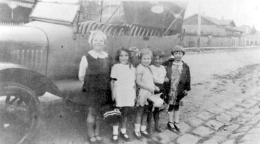
Photograph, Children in Wandsworth Road, Surrey Hills
Local children in Wandsworth Road, c1930 Taken outside No. 44, home of the Stalker family, later that of Howard and Mary Everard, nee Stalker. Betty Stalker is on the left. The car is a Dodge c1920. House just seen at left is No. 57 then home of the Butler family. To the right is No. 61, the Stevens family one. Further research: Betty Neil Smith (Stalker) was born in 1919 in Balwyn (Surrey Hills). She was one of 4 daughters of Alexander MacLaren Stalker (1885-1970/1973) and Charlotte Eleanor Hayward (1884-1953) who were married in 1911. Her sisters were, Betty Neil Stalker and Ruth McLaren Stalker (1913, Surrey Hills), Joan Winnock Stalker (1917, Surrey Hills) and Beatrice Mary Stalker (1919). Their mother Charlotte Hayward was a teacher prior to her marriage. Their father Alexander, an accountant, lived in Wattle Valley Road, Canterbury in 1910. From 1912-1931 they are listed at ‘Benwerrin’, (44) Wandsworth Road, Surrey Hills. This was later the home of Beatrice Mary and Howard Everard. Betty, Ruth and Joan later lived at 9/48 Wandsworth Road. The 1931 electoral roll has Olive Myra Butler (machinist), Herbert Arthur Butler (carpenter), Ernest Philip Butler (pastrycook), Mary Butler and Hilda Jarrett Butler (machinsit) at 59 Wandsworth Road ('Bona Vista'). The 1936 electoral roll has Hugh Joseph Stephens (fireman), Ada Agatha Stephens (HD), Mary Christina Stephens (dressmaker) and Sylvia Ada Stephens (dressmaker) at 63 Wandsworth Road. Hugh and Ada are at the address in earlier electoral rolls. It is presumed that these are the families referenced in the general information noted by Jocelyn Hall. A black and white photograph of some children standing beside a dodge car. At least one is a member of the Stalker family.surrey hills, wandsworth road, (mr) howard everard, (mrs) mary everard, (miss) mary stalker, (miss) betty stalker, dodge, butler family, stevens family, cars, (mrs) betty smith, (miss) beatrice mary stalker, (mrs) beatrice mary everard, (miss) joan winnock stalker, (miss) betty neil stalker, (miss) ruth mclaren stalker, bluestone kerbing, children -
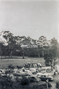
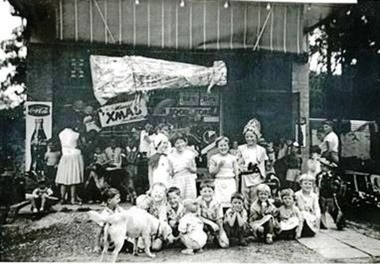
 Ringwood and District Historical Society
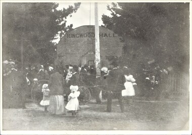
Photograph, Ringwood Hall, Mount Dandenong Road, Ringwood - circa 1900, Circa 1900
Ringwood Hall was located near the Club Hotel in Mount Dandenong Road prior to construction of Mechanics Institute/Town Hall in Maroondah Highway in 1909.Black & white photo of crowd gathered at original Ringwood Hall, Mount Dandenong Road, Ringwood. "Old Ringwood Hall nr. Club Hotel, later burnt down approx 1909". "Old Ringwood Hall prior to Mech Inst of 1909". -
 Eltham District Historical Society Inc
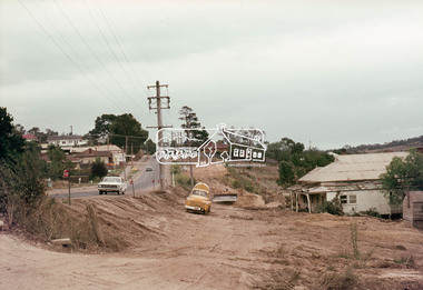
Photograph, Main Road widening, Eltham, c.March 1968, 1968
Immediately prior to duplication of Main Road. Looking south from Eltham Shire offices. Remains of old Gahan house on right just prior to demolition35mm Colour positive transparency Mount - Agfacolor Service (Blue stepped)duplication, eltham, gahan house, main road -
 Eltham District Historical Society Inc
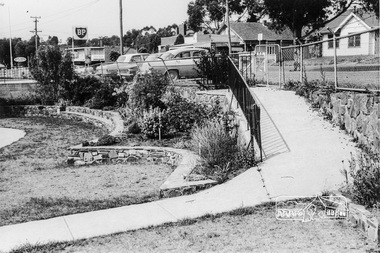
Photograph, War Memorial Garden, Main Road, Eltham, February 1968, Feb 1968
Shows the ramp leading into the gardens from Main Road which lead to the Children's Library and Pre-school buildings. BP Service Station immediately to the leftIn February 1968 an unknown person took a series of photos from the Eltham Hotel at Pitt Street heading north along Main Road through the shopping centre to just north of Elsa Court covering the length of the section of Main Road which was duplicated shortly thereafter. Shows the condition and environment of the streesscape of Main Road, Eltham immediately prior to the duplication between Pitt Street and Elsa Court through the shopping centre. Also shows a number of shops and businesses that operated at that time.Black and white photographduplication, eltham, main road, shire of eltham war memorial, pre-school, children's library, bp service station -
 Eltham District Historical Society Inc
Photograph, Russell Yeoman, Main Road duplication roadworks between Bridge Street and Shire of Eltham offices, 1968, 1968
Viewed from the southern end of the Eltham Shire Office, Panther Place in centre distance and Bridge Street in distance running down from Main RoadDigital file only; created from original colour positive slide transparencystreets, main road, eltham shire office, bridge street, duplication, panther place, road construction, road widening, russell yeoman collection -
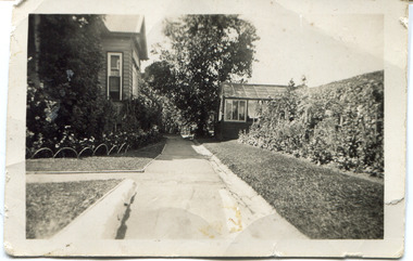 Surrey Hills Historical Society Collection
Digital photo, 45 Wandsworth Road, Surrey Hills, 1956
According to the donor, the photo was taken before the driveway was constructed. The house was later extended at the rear and was re-roofed. The donor's grandparents Daniel Patrick Liddy and Beatrice Bridget Tyner (known as 'Beat') were married in at her parents' home in Glencoe, South Australia on 13 December 1908. They lived in the Carlton / North Melbourne area before moving to Surrey Hills. Electoral rolls list them at 92 Curtain Street, North Carlton in 1913. According to the donor, they rented several properties before purchasing 45 Wandsworth Road. They are listed at Albert Crescent in 1914 and 1919, but also lived in Zetland Road. They purchased 45 Wandsworth Road in c1923 and are listed in the electoral rolls there in 1924. The donor's mother Ellen Dorothy Liddy (known as Eileen) was born in 1909; her brother Daniel John Liddy was born in 1911, both in Carlton. Daniel Patrick Liddy died in 1955; his wife Beatrice died in 1959. They are buried in Box Hill Cemetery (RC183-0045). 45 Wandsworth Road was their home for over 30 years.This image is material evidence of a property that has been demolished.A black and white photo taken from the street looking up a path or narrow driveway. On the LHS is part of a weatherboard house, Edwardian in style. On the RHS is the boundary fence against which is a garden border separated from the driveway by a section of grass. In the background is a glasshouse.Rear along top edge in blue biro: "Aunty Eileens house / before she was married" - according to the donor, this is his cousin's writing. Aunty Eileen was Ellen Dorothy Liddy who married Hugh Turnbull in 1936. Along LH edge, perhaps in a different hand " 23-10-1956" Photo laboratory processing stamp in black ink " 2 48", stamped twice.wandsworth road, daniel patrick liddy, beatrice bridget tyner, beatrice bridget liddy, ellen dorothy liddy, daniel john liddy, box hill cemetery, gardens -
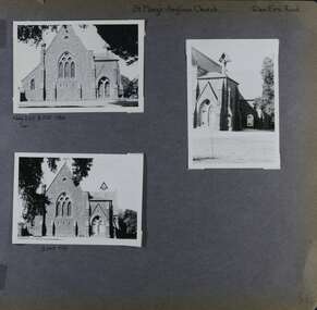 Glen Eira Historical Society
Album - Album page, St Mary's Anglican Church, Glen Eira Road, Circa 1972
This photograph is part of the Caulfield Historical Album 1972. This album was created in approximately 1972 as part of a project by the Caulfield Historical Society to assist in identifying buildings worthy of preservation. The album is related to a Survey the Caulfield Historical Society developed in collaboration with the National Trust of Australia (Victoria) and Caulfield City Council to identify historic buildings within the City of Caulfield that warranted the protection of a National Trust Classification. Principal photographer thought to be Trevor Hart, member of Caulfield Historical Society. Most photographs were taken between 1966-1972 with a small number of photographs being older and from unknown sources. All photographs are black and white except where stated, with 386 photographs over 198 pages.From the Victorian Heritage Register Database - Citation for St Mary's Anglican Church https://vhd.heritagecouncil.vic.gov.au/places/43715 (as at 14/10/2020) St Mary's has architectural significance as a representative example of French influenced Low and Mixed Gothic (see stylistic Typology in National Trust's Historic Churches Study) and is further distinguished by its use of bluestone, entirely without relief. French influence is demonstrated by the high nave, apsidal sanctuary, spirelet and trumeau. The building is locally important as a historic focus for Anglican worship and early mission activity whilst its architectural grandeur is expressive of mid Victorian Caulfield's status as a suburban location for the Metropolis gentry.Page 56 of Photograph Album with three exterior photographs (two portrait and one landscape) of St Mary's Anglican Church.Hand written: St Mary's Anglican Church Eira Road [top right] / Neg 235 8 Oct 1966 [under top left photo] / 3 Sep 1972 [under bottom left photo] / 56 [bottom right] trevor hart, 1880's, elsternwick, glen eira road, st kilda east, church of england, gothic, st mary's, bluestone, apsidal sanctuary, spirelet, trumeau, anglican, 1870's, caulfield north, french-influenced low and mixed gothic style -
 Eltham District Historical Society Inc
Photograph, Cottage, cnr. Reynolds Road and Mount Pleasant Road, Eltham 1990, 1990
Colour photograph of cottage at corner of Mount Pleasant Road and Reynolds Road, Eltham, 1990houses, eltham, mount pleasant road, reynolds road -
 Tarnagulla History Archive
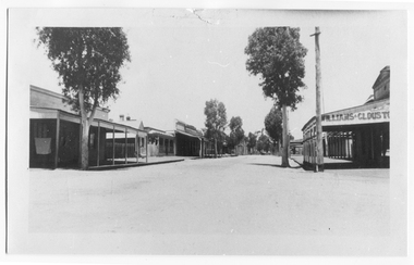
Photograph looking up Commercial Road, Tarnagulla, Looking up Commercial Road, Tarnagulla, c.1960s
Murray Comrie Collection. Original print.Monochrome photograph. View looking up Commercial Road, Tarnagulla, from the Poverty Street intersection. Street deserted - no people or vehicles visible. Building with text 'Williams & Clouston's' visible at far right. Willersdorf;s store opposite, and the Borough Council Chambers can vaguely be seen in the left distance. tarnagulla, businesses, commercial road -
 Greensborough Historical Society
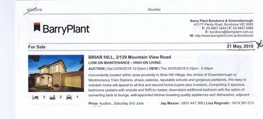
Advertising Leaflet, 2/129 Mountainview Road Briar Hill, 29/06/2018
2/129 Mountainview Road Briar Hill, 3 bedroom, 2 story home. Sold 29/06/2018 for $638.500, previously March 2014 for $475,000Real estate advertising leaflet, 1 sheet, printed in colour.mountainview road briar hill -
 Greensborough Historical Society
Photograph - Digital Image, Marilyn Smith, Greensborough Grain Store, 183 Para Road. Architectural detail, 06/11/2017
This photograph shows architectural details of the building at 183 Para Road when it was used for Greensborough Grain Store; front door and bluestone steps, trellis and internal shelving.In 2017, the Greensborough Grain Store closed its Para Road premises and now trades online.Digital copy of colour photographgreensborough grain store, para road greensborough -
 Eltham District Historical Society Inc
Photograph, M. North, Main Road, Eltham near Fitzsimons Lane Roundabout, Dec 1985, 1/12/85
Two colour photographs of Main Road, ElthamSouth between Falkiner Street and Bolton Street at the roundabout of Fitzsimons Lane, Eltham, Dec 1985Noted on 463B 'See 1934 small black and white snap of flooded bridge and the same two shops. This snap taken from same location, Dec 1985. Old Eltham Park on right of photo The two shops at left (Ansel and Muir) Road ahead crosses new bridge over the Diamond Creek, Eltham Main Road now dual highway, through Lower Plenty to this bridge'main road, eltham, eltham south, fitzsimons lane, round about, falkiner street -
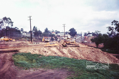
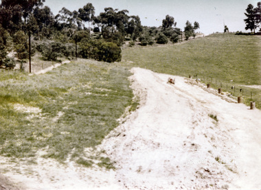 Eltham District Historical Society Inc
Photograph, Pasture with new road
Probably the Bassett-Smith property at Menzies Road, Kangaroo Ground. Probably one of a series of photos (not identified in EDHS collection) showing purpurted excavation works, possibly road making. No date 1 colour photographBack: "N.B. the left hand side of the excavation was once used in a similar manner but is once more under pasture." 17 peter bassett smith, kangaroo ground, road making, pasture, farm -
 Whitehorse Historical Society Inc.
Document, Blackburn Road Rail Crossing Removal Project, 2012
Information update issued by VicRoads.Information update issued by VicRoads regarding the planned removal of the rail crossing at Blackburn Road, and improvements to the Blackburn Railway Station.Information update issued by VicRoads.blackburn railway crossing, blackburn railway station, blackburn road, blackburn -
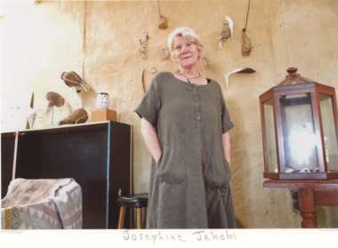 Lakes Entrance Historical Society
Photograph, EG Newspaper, Josephine Jakob artist shown in her studio with some of her creations Colquhoun Road Lakes Entrance
artist shown in her studio with some of her creations Colquhoun Road Lakes EntranceColour photograph of Josephine Jakob artist shown in her studio with some of her creations Colquhoun Road Lakes Entrancearts and crafts, events -
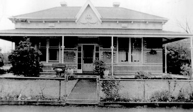 Surrey Hills Historical Society Collection
Photograph, 2-4 Kent Road, Surrey Hills, 1987
'Rangitera' - 4 Kent Road - this house has been demolished. It was the address of Campbell Craven Dobbie c1909. He is variously listed as a commercial traveller / printer in electoral rolls. In 1906 he lived in Barton Street and from 1921-1914 is listed at 'Rangatea', Union Road, Balwyn. He served in WW1 in the 8th battalion as a captain; enlisted 4 September 1914 and returned 9 September 1916. Had a son Pat (REF: Trove Obituary, Argus, 27 March 1945)A black and white photograph of a Edwardian style / Federation style house with a cyclone fence and gate at the front of the property.kent road, surrey hills, campbell dobbie (capt), campbell craven dobbie (capt), world war 1, house names, 'rangitera', 'rangatea' -
 Eltham District Historical Society Inc
Slide - Photograph, Possibly the Ersilac Parade travelling along Main Road, Eltham, c.1958
View from Grace Mitchell's shop at the corner of Mount Pleasant Road and Main Road. Grace Mitchell was probably best known for her Eltham shop at the corner of Mt Pleasant Road and Main Road. Grace's memories covered many local identities who were patrons of her shop between 1954 and 1971. From the elevated position of her shop and home Grace was able to view a varied passing parade of Eltham events from ERSILAC, Easter and Eltham Festival parades passing on their way to Eltham Lower Park, circuses in Wingrove Park (then Bremner’s Reserve), roadworks and other happenings. Bremner's Reserve was renamed Wingrove Park c.1970 This photo was from a series of images presented by Grace Mitchell at a Society talk 10 March 1993 on the theme of “My Eltham”. Alistair Knox had one of the first VW Beetles in Eltham; perhaps the one shown is his. This model has a large rear window, first introduced in 1958. The Holden ute could be an FC or FE. The FE was produced July 1956-April 1958 and the FC May 1958-January 196035mm Kodak 5052 TMX Black and White transparency, 1 strip, 6 frames Black and white print 17 x 25.4 cmcars, bremner's flat, eltham, ersilac parade, main road, mount pleasant road, wingrove park, festival, horse drawn carriage -
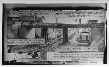 Melbourne Tram Museum
Photograph - Black and White, Epson Road Rail Bridge under construction, Early 1925
Image shows a newspaper photo of the MMTB U Class Tram 203 on temporary track at east side of excavation for underpass in Epson Road Flemington with Racecourse railway line to eliminate level crossing. The road was often closed to all traffic, including trams on race days by the railways. The work was completed in April 1925MMTB U Class trams were built for the former operator NMETL, with the photo showing an early level crossing abolition project. Black and White photo Epson Road Rail Bridge under construction with MMTB U Class tram on temporary track tramways, trams, epson road bridge, u class, flemington, tram 203 -
 Glen Eira Historical Society
Album - Album page, Grimwade House, Orrong Road, Circa 1972
This photograph is part of the Caulfield Historical Album 1972. This album was created in approximately 1972 as part of a project by the Caulfield Historical Society to assist in identifying buildings worthy of preservation. The album is related to a Survey the Caulfield Historical Society developed in collaboration with the National Trust of Australia (Victoria) and Caulfield City Council to identify historic buildings within the City of Caulfield that warranted the protection of a National Trust Classification. Principal photographer thought to be Trevor Hart, member of Caulfield Historical Society. Most photographs were taken between 1966-1972 with a small number of photographs being older and from unknown sources. All photographs are black and white except where stated, with 386 photographs over 198 pages. From Victorian Heritage Database citation HO54 Grimwade House, former Harleston stables, outbuilding, garden, gate and Picconia excelsa tree. https://vhd.heritagecouncil.vic.gov.au/places/35573 as at (28/10/2020) ''Harleston'', now "Grimwade House", is situated at no. 67 Balaclava Road, Caulfield North, at the Orrong Road corner. It was built for Frederick, later Sir Frederick, Grimwade, to the design of architect Thomas Watts in 1875. Today the complex has been incorporated in the Melbourne Grammar Junior School campus. It retains not only the main house but also the stables and mature garden setting with driveway and gates. It is historically, aesthetically and socially significant.From Victorian Heritage Database citation HO54 Grimwade House, former Harleston stables, outbuilding, garden, gate and Picconia excelsa tree. https://vhd.heritagecouncil.vic.gov.au/places/35573 as at (28/10/2020) It is historically significant (Criterion A) as the former home of prominent business man, speculator and benefactor, Sir Frederick Grimwade. Both Grimwade and his house are exemplars of the commercial enterprise of the Boom period and the amassing of personal fortunes with which it is associated. It is aesthetically significant (Criterion E) as an imposing yet stately large house of its time, the classic Italian form with comer verandah terminated by projecting wings being most distinctively seen in this instance. It is enhanced not only by the garden setting but also by the delicate cast iron verandah spandrels, stained glass work and stencilled ceiling in the music room. It is socially significant (Criterion G) on account of the value placed on it by the community associated with the Melbourne Grammar Junior School since its inception on this site in 1911.Page 154 of Photograph Album with five photographs (4 landscape and one portrait) including Grimwade House, gates and a tram shelter.Handwritten: Grimwade House (Melbourne Grammar Prep School) / incorporating "Harleston" Orrong Rd. S.E cnr Balaclava Rd [top right] / 154 [bottom right]trevor hart, verandah, porch, slate roof, garden, grimwade house, grimwade, harleston, sir frederick grimwade, thomas watts, orrong road, balaclava road, melbourne grammar, melbourne grammar junior school, italianate, cast iron verandah spandrels, stained glass, stencilled ceiling, mgs, m.g.s, school, grimwade family, jessie grimwade, gates, palisade style fence, cast iron spears, stone plinths, melbourne grammar prep school, victorian style, cast iron work, caulfield north, gardens, cars, tram services, outbuildings, stables, trees, picconia excelsa tree -
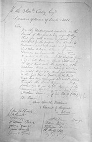 Ringwood and District Historical Society
Photograph, Petition 4/9/1872 for road to Melbourne from "Blood's Hill" (eventual corner of Bedford Road and Dublin Road, Ringwood East). Canterbury Road was later extended as a result of the petition
Catalogue card reads, 'Petition 4/9/1872 "for road to Melbourne". -
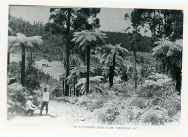 Mt Dandenong & District Historical Society Inc.
Photograph, View From Doughty's Road 1913
Mt Calvin, the homestead of Jeanie and Willie Richardson can be clearly seen in the clearing above the men in the picture. The white roof of the Barber homestead is on the right of the picture. A landslide in 1934 destroyed the tree ferned area. John Lundy-Clarke grew up in the Kalorama/Mt Dandenong area and later in life (1972-74) began to write a comprehensive history of the area working from an original settlement map in an effort to cover all areas.Black and white photograph that is a copy of a Rose series postcard titled 'The Picturesque Road to Mt. Dandenong. Vic.' It shows two men (probably Rose Series employees), one sitting and one standing at the edge of an unmade road. Large tree ferns line the roadside. Handwritten inscription on reverse by John Lundy-Clarke1913 View east from Doughty’s Road showing Jeannie Richardson’s home through the gap in the trees. A little to the right of and below centre of picture can be seen George Barber’s home with Barbers Road turning around the wagon shed that was a little up the hill from the house. The tree ferns in the picture were destroyed in the landslide of 1934. In the distance at the right can be seen F.M. Childs Homestead complex with the Richardson paddocks beyond it.mt calvin, jeanie richardson, willie richardson, george barber, landslide, tree fern -
 Ringwood and District Historical Society
Photograph, Warrandyte Road (unmade Road). Ringwood. (undated, probably late 1960's/early 1970's)
Written on catalogue card, "Warrandyte Road". -
 Greensborough Historical Society
Photograph - Digital Image, Greenhills Road shop 1950s - children eating ice cream, 1950s
Local children at Christmas party at shop in Greenhill Road Greensborough. In this photo the children are eating ice creams. This shop has had many tenants and is currently the "Clay Oven" restaurant.Digital copy of black and white photograph.greenhill road -
 Greensborough Historical Society
Photograph - Digital Image, Greenhills Road shop 1960, 1950s
Local children at Christmas party at shop in Greenhill Road Greensborough. This was the first Christmas that the shop was open 1960. This shop has had many tenants and in 2016 is the "Clay Oven" restaurant.Digital copy of black and white photograph. clay oven restaurant, dobells, greenhill road -
 Ringwood and District Historical Society
Photograph, Intersection of Tortice Drive, Old Warrandyte Road and Warrandyte Road 1981
Written on back of photograph, "19/6/81. Intersection of Tortice Drive, Old Warrandyte Road and Warrandyte Road." -
 Ringwood and District Historical Society
Photograph, Old house, Old Warrandyte Road, Ringwood, nearly opposite Quamby Road, 1978
Written on back of photograph, "Old house, Old Warrandyte Road, nearly opposite Quamby Road, June 1978". -
 Ringwood and District Historical Society
Photograph, Intersection of Warrandyte Road and Oban Road, North Ringwood. Looking south-east. 1981
Written on back of photograph, "18/4/81. Intersection of Warrandyte Road and Oban Road. Looking south-east". -
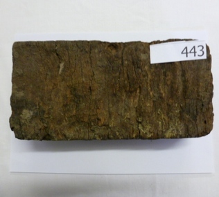 Greensborough Historical Society
Brick, Wooden road block, 1880s
Accompanied by article by Kevin Patterson (Nillumbik Historical Society) which explains the use of these blocks as a road surface in the City of Melbourne from the 1880s. The final wood blocks were dismantled in the 1950s and blocks sent to suburban wood yards to be sold as fuel for open fires and combustion heaters.As most of these blocks were sold for fuel, it is unusual to find one surviving. Block of timber cut to size and dipped in tar for use a a road block. wood blocks, paving, melbourne, road surfaces, tar -
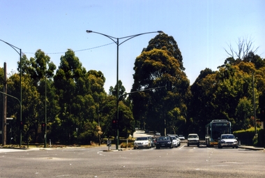 Whitehorse Historical Society Inc.
Photograph, Blackburn Road/Canterbury Road, Blackburn South, 2012
See NP4006Coloured photograph of Blackburn Road/Canterbury Road intersection. Cars coming from Blackburn - 2012blackburn road, blackburn south, canterbury road -
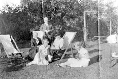 Surrey Hills Historical Society Collection
Photograph, Sunday afternoon at 'Dalriada' 77 Union Road, Surrey Hills
‘Dalriada’” at 77 Union Road, on the corner Bona Vista Avenue has been demolished. It was the home of Mr Charles Henri Dillon Steele, a dentist of Collins Street, his wife Sarah (nee Russell) and daughters Harriette Vevers (Hattie) and Margaret Dillon (Nancy). They are pictured with grandmother Mrs Sarah Ann Vevers Russell (nee Lasslett), who with her husband Alexander lived at 'Clifton', Union Road, Surrey Hills from prior to 1903. He died in 1903 at Clifton. She was still living there in 1919. A black and white photograph of a group of people in their garden, enjoying the sun. The man is standing, two older ladies are sitting on deck chairs and the two younger girls are sitting on the grass playing with a kitten.(mr) charles steele, dalriada, house names, surrey hills, bona vista avenue, (mrs) sarah steele, clothing and dress, union road, (miss) harriette vevers steele, (miss) hattie steele, (miss) nancy steele, (miss) margaret dillon steele, (mrs) sarah ann vevers russell