Showing 3063 items matching "scales"
-
 Federation University Historical Collection
Map, Creswick Gold Field Map, 1981
A fragment of the original 1880 map is also held in the collection. See 116Rectangular geological map with brown paper strip on top edge with 4 holes on top edge. Scale is 40 chains to one inch.Geologically and topographically surveyed by Ferdinand M Krause. Lithographed by R. Shepherd. Printed by J. Finnie. Mining Department, Melbourne. Preprinted with additional shaft and lead detail. F. D. Atkinson, Government Printer 1981creswick, krause, surveyor, smeaton, spring hill, tourello, ascot, dean, bullarook, gold fields, gold -
 Federation University Historical Collection
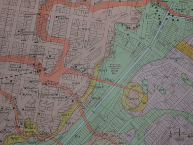
Plan, Ballarat Goldfield - Geological Survey of Victoria, 1981, 1981
Coloured geological plan showing the Ballarat goldfields. It includes coloured scales and nuggets from the Ballarat Goldfield. It also shows leads and mines.ballarat, geology, geological, gold nuggets, mining, mining companies, gold leads -
 Federation University Historical Collection
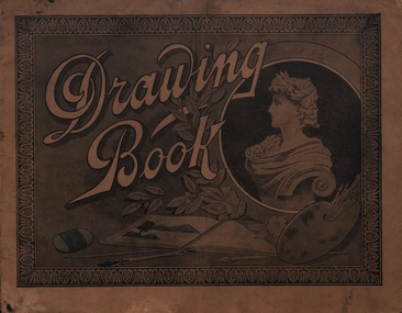
Booklet - Sketchbook, Sketchbook in Geometry, 1921
Art Student's Drawing Book completed by Mary Rash. It has been used for geometry, including Geometry and Model Drawing and Scale Drawingmary rash, geometry -
 City of Moorabbin Historical Society (Operating the Box Cottage Museum)
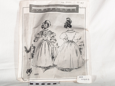
Craft - Dress Pattern Bi-centennial 0001, c1988
A Bi-Centennial Dress Pattern 0001 made by Lindie Ward for Power House Museum . It is a copy of a dress belonging to Isobel Hovell, the wife of the explorer William Hovell. Isobel died 1837. The original dress was made from yellow, satin -striped, cotton voile, printed with sprigs of flowers in lilac and greenThis Dress Pattern was made for the Bi-Centennial Celebrations at Power House Museum, Sydney in 1988c1988 A large paper envelope with printed design of dress c1837. Dressmaking tissue pattern pieces for dress are enclosed and a measurement scale is on the backFront of packet : BICENTENNIAL DRESS PATTERN / POWERHOUSE / 0001dressmaking, craft equipment, dress patterns, craftwork, sewing, hovell isobel, hovell william, ward lindie, bi-centennial celebrations, melbourne, moorabbin, victoria, new south wales, market gardneres, power house museum -
Port Melbourne Historical & Preservation Society
Map - MMBW, 1895
MMBW 1895 Plan No's. 344 to 349 Segment: Ingles to Bridge, Nott to Esplanade East (on south) Scale 40ft=1" (large)311/H 22melbourne and metropolitan board of works, port melbourne town hall, built environment, business and traders - hotels -
 National Vietnam Veterans Museum (NVVM)
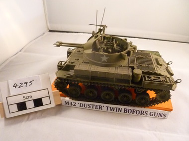
Model - Model, M 42 tank
US Army M42 tank called "Duster" with twin Bofors guns. Tank is scale model on orange plinth painted in olive drabWhite US Army Stars on turretm42, tank, duster, bofors, model -
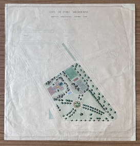 Port Melbourne Historical & Preservation Society
Plan - Edwards Park improvements (Trugo Green), Port Melbourne, 1940s - 1950s
Although undated, this plan is probably from the late 1940s or early 1950s. Around this time Port Melbourne Council were looking to built a basketball court in Lagoon reserve, and shelters and a senior citizen's clubhouse in Edwards Park. PMHPS does to believe the basketball court shown in the plan was built but the Port Melbourne Senior Citizens and Trugo Club is at the location shown on the plan. A shelter is in a similar location to the one on the plan. A children's playground existed in that location shown in a photograph from the 1930s. The round flowerbed where the paths cross in the centre of the park in not in the 1930s photograph but is a current feature of Edwards Park.Plan drawing to scale, hand coloured, of proposed improvements to Edwards Park (Trugo Green), undated possibly late 1940s or early 1950s."City of Port Melbourne"built environment - recreational facilities, parks and gardens, sport - trugo, port melbourne trugo club, edwards park -
 Bendigo Historical Society Inc.
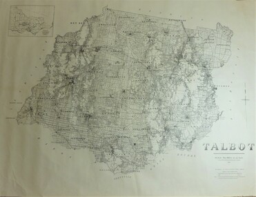
Map - JACK FLYNN COLLECTION: TALBOT, 1937
Map: County of Talbot, map sheet showing the whole of the County of Talbot and all of the Parishes within. Scale 2 Miles to 1 inch.By Authority: A.C. Brooks, Government Printer, Melbourne. Department of Lands and Survey Melbourne. 1959map, talbot, county, talbot -
Bendigo Historical Society Inc.
Map - BIG 180 SHAFT POSITION, No date visible
Map: Plan showing the location of various shafts in the Victoria Hill area, hand draughted in pencil. Scale 2 Chains to 1 inchmap, bendigo, mining plan, mining , gold mines. victoria hill, big 180 -
Bendigo Historical Society Inc.
Map - BENDIGO GOLDFIELD, No date visible
Map: Bendigo Goldfield. Scale 20 chains to 1 inch. Printed by Cambridge Press, Bendigo. (number 318 in map cupboard 1)map, bendigo, mining plan, bendigo goldfield, gold mines, mining -
 Stawell Historical Society Inc
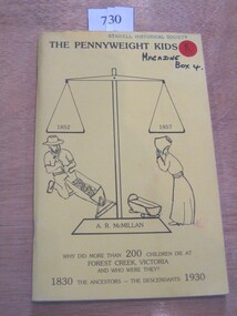
Book, A. R. McMillan, The Pennyweight Kids - 1852-1857, 1988
The Story of the children who lived and died with the killer diseases of the last century (1800's). Theere is a preservation order now on force to restore the cm=emetary.Yellow Card Cover with black in drawing of Large balance scale. A Miner slucing gravel to the left and a woman looking at an empty cradle to the rightThe Pennyweight Kids 1852 1857 A.R. McMillan Why did more than 200 children die at Forest Creek Victoria and who were They? 1830 The Ancestors - The Descendants 1930 Inside: To The Stawell Historical Society from the Authorcastlemaine -
Whitehorse Historical Society Inc.
Map, Shire of Blackburn and Mitcham, 10/10/1939 update
Map of Shire of Blackburn and Mitcham showing Departmental ball hydrants and departmental pillar ball hydrants.Map of Shire of Blackburn and Mitcham showing Departmental ball hydrants and departmental pillar ball hydrants. Scale 8 chains to 1 inch.Map of Shire of Blackburn and Mitcham showing Departmental ball hydrants and departmental pillar ball hydrants.shire of blackburn and mitcham, fire hydrants, blackburn, blackburn north, blackburn south, burwood east, forest hill, mitcham, nunawading, vermont, vermont south -
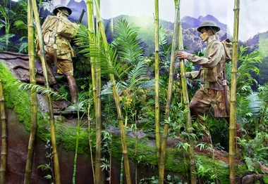 Australian Army Museum of Western Australia
Diorama, 2015
This diorama is the central feature in the World War 2 Gallery - South West Pacific area. Soldiers are shown still wearing khaki uniforms including shorts. Details include helmet, .303 SMLE rifles, small pack and fighting order. Japanese "Woodpecker" machine gun is show abandoned beside the track.1:1 scale diorama showing Australian patrol advancing up the Kokoda Track in light fighting order circa August 1942.kokoda -
 Australian Army Museum of Western Australia
Diorama, 2015
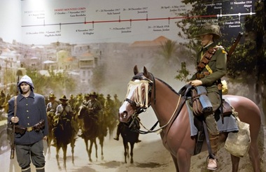
This diorama is the central feature in the World War 1 Gallery - Middle East Campaigns sequence and shows typical uniforms and accoutrements of the Australian Light Horse and Ottoman infantry.This diorama attempts to convey the conditions experienced and the country traversed during "The Great Ride"1:1 scale diorama showing mounted trooper of 10th Australian Light Horse Regiment in Palestine 1918 and dismounted Ottoman soldiergaza, beersheba, light horse -
 Australian Army Museum of Western Australia
Diorama, 2015
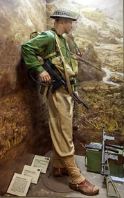
This diorama is the introductory feature in the World War 2 Gallery - New Guinea and Islands area. A private soldier is shown in mixture of green and khaki uniforms, US style long leggings, long trousers with Thompson and Owen guns.The diorama shows the gradual introduction of green uniform elements and recognition of passive anti malaria measures (long sleeve and long pants)1:1 scale diorama showing soldier of Australian soldier of the 7th Division at the time of the advance into the Markham and Ramu Valleys, September 1943ramu, markham, shaggy ridge, 7th division, 9th division -
 Australian Army Museum of Western Australia
Diorama, 2015
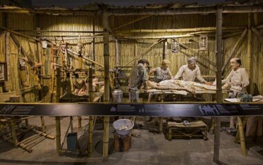
This diorama is the focal point the Prisoner of War Gallery. It was originally designed and installed by a collaborative group of artists and craftsmen, all themselves former Prisoners of War in 1995. Bamboo for the display and replica prosthetics was sourced from Thailand. The mannequins are artistic interpretations of identified POW surgical staff and doctors. The original display was moved and reassembled during the Gallery redevelopment process in 2015. All items presented within the diorama are based on POW recorded drawings and diaries of experiences in the Thai Burma Railway POW camps.1:1 scale diorama showing operating theatre in POW camp on Burma Thai Railway together with reproductions of prothesis and improvised equipmentthai burma railway; -
Beechworth Honey Archive
Map- Eldorado
Compiled from 1971 aerial photography. Printed in 1978.Map shows Eldorado town, Reedy Creek, abandoned gold dredge and Monument Hill. Scale 1:25,000. Printed colour on paper.Map labelled Eldorado. No. 8225-3-4map, eldorado, reedy creek, dredge, monument hill, aerial photography, paper, beechworth honey -
University of Melbourne, Burnley Campus Archives
Plan - Photocopy, Jan Horner, 24 Selbourne Road Toorak Concept Plan, 2000
Photocopy of plans by Jan Horner, 16 December 2000. Scale 1:50. (1) Concept Plan. (2) One Point Perspective.jan horner, toorak, garden design -
University of Melbourne, Burnley Campus Archives
Plan, City of Keilor, Delahey Recreational Reserve, Tennis Complex, Goldsmith Ave, 1994
(1) Planting Plan, coloured, dated 19.08.1994, Sheet 3 of 3. by J.Coghill. Scale 1:100. (2) Sheet 2 of 3.keilor, delahey recreational reserve, , j. coghill, planting plan -
University of Melbourne, Burnley Campus Archives
Plan, Colleen Miller, Williamstown North Primary School Japanese Gravel Garden, 2002
(1) Section Elevations by Colleen Miller, dated 26.06.2002. Scale 1:50. (2) Page with 2 colour photographs of the garden/similar.colleen miller, williamstown north primary school, japanese garden -
 Beechworth RSL Sub-Branch
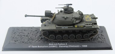
Model Tank M48 A3 Patton 2 model tank
Scale model M48 A3 Patton 2 Tank;Olive green colour with yellow and white writing, mounted on black plastic board.Printed on mounting board " M48 A3 Patton 2/ 1st Tank Battalion (USMC) Danang (Vietnam) - 1968; above drive track "USMC 202149" a shield with the number 1 above letters TK; on the rear of the tank behind the turret is C-34; on the barrel right hand side "C-34" in yellow print followed by "TULA" in white print/ on the rear view on left side drive track mudguard "C-34" in yellow and on Rear right hand side " a shield with the number 1 above letters TK/ front view the number "54" in yellow print on left hand drive track/ in the centre below the barrel is the shield/ on the right hand drive track mudguard is "C-34" in yellowtank, model tank m48 a3 patton 2, scale model, c-34 tank -
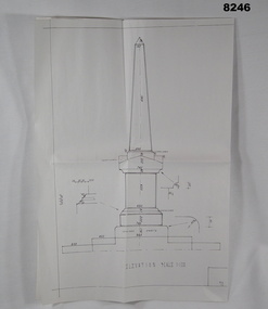 Bendigo Military Museum
Plan - MONUMENT PLANS, C.1992
Plan for Monument in front of the Soldiers Memorial Institute Pall Mall Bendigo, refer Cat No 8245.2.Plan, white paper, all black ink of a proposed Monument, scale 1:100 showing front elevation, plan and section A.A"Proposed Monument to Ex Servicemen and Women to be erected in Pall Mall Bendigo"brsl, smirsl, monument, plan -
Glenelg Shire Council Cultural Collection
Plan - Plans / Line Drawings - Port of Portland Authority Slipway Bilge Blocks Trawler Barameda, Victoria, 23/02/1988
PORT OF PORTLAND AUTHORITYFront: '9' - black texta, top right corner -
Glenelg Shire Council Cultural Collection
Plan - Plans - Port of Portland Slipway - Steel Trawler 'Aqua Enterprise', 02/10/1980
PORT OF PORTLAND AUTHORITYFront: '18' - black texta, top right corner -
Glenelg Shire Council Cultural Collection
Plan - Plans / Line Drawings - Port of Portland Authority Slipway Bilge blocks, Fishing Vessel Santa Lucia, Victoria, 11/06/1987
PORT OF PORTLAND AUTHORITYFront: '15' - black texta, top right corner -
Glenelg Shire Council Cultural Collection
Plan - Plans / Line Drawings - Port of Portland Authority Slipway Fishing Vessel Soluna, Victoria, 06/10/1989
Port of Portland AuthorityFront: '33'- black texta, top right corner. 'JOB NO 3110' - black pen -
Glenelg Shire Council Cultural Collection
Plan - Plans / Line Drawing Portland Harbour Trust Slipway, bilge blocks, vessel 'HA Lumb', 30/06/1978
Front: 31- black texta, top right cornerport of portland -
Glenelg Shire Council Cultural Collection
Plan - Plans - Port of Portland Slipway Fishing vessel 'Marian H.', 16/03/1983
Front: '40' - black texta, top right cornerport of portland -
Glenelg Shire Council Cultural Collection
Plan - Plan - Port of Portland Slipway, Twin Screw Tug, 16/03/1981
Front: - black texta, top right cornerport of portland -
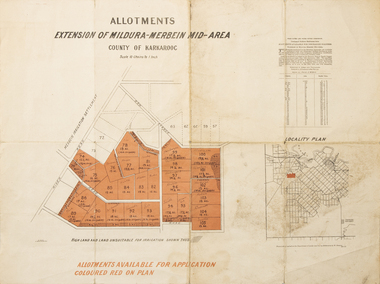 Merbein District Historical Society
Map - Allotments Extension of Mildura-Merbein Mid-Area, Allotments available, 23 November 1920
Allotments available to Discharged Soldiers Discharged Soldier's Settlement Act Historic Large map, folded in 4, coloured map of Merbein indicating allotments available and locality plan. Scale 10 chain to 1 inchPhoto-Lithographed at Department of lands Survey, Melbourne J. Butson 23.11.20discharged soldiers, ww1, soldier settlement, irrigation