Showing 843 items
matching subdivision plan
-
 Whitehorse Historical Society Inc.
Pamphlet, Blackburn bellbird area, 1986
... Pamphlet on proposal to extend planning controls over... on proposal to extend planning controls over buildings, subdivision ...Pamphlet on proposal to extend planning controls over buildings, subdivision and tree removal introduced in 1985.Pamphlet on proposal to extend planning controls over buildings, subdivision and tree removal introduced in 1985. Now these controls are proposed to extend over a further 53 streets in Blackburn's 'Bellbird Area'.Pamphlet on proposal to extend planning controls over buildings, subdivision and tree removal introduced in 1985. town planning, victoria. department of planning and environment, blackburn -
Whitehorse Historical Society Inc.
Letter - Correspondence, Abattoir Property, 1937
... and Mitcham re sale of abattoir property with a plan... sale of abattoir property with a plan of the subdivision ...Letters between City of Box Hill and Shire of Blackburn and Mitcham re sale of abattoir property with a plan of the subdivision.Letters between City of Box Hill and Shire of Blackburn and Mitcham re sale of abattoir property with a plan of the subdivision.Letters between City of Box Hill and Shire of Blackburn and Mitcham re sale of abattoir property with a plan of the subdivision.city of box hill, shire of blackburn and mitcham, abattoirs paddock, aspinall's estate, woodhouse grove, box hill north, aspinall road, box hill north, koonung creek, land subdivision -
 Whitehorse Historical Society Inc.
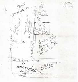
Document, 1924 Tunstall Properties, 11/02/1924 12:00:00 AM
... Mitcham melbourne plans whitehorse road nunawading tunstall ...Hand drawn plans of properties bordered by Tunstall (Nunawading) Railway Station,Hand drawn plans of properties bordered by Tunstall (Nunawading) Railway Station, Springvale Road and Springfield Road.Hand drawn plans of properties bordered by Tunstall (Nunawading) Railway Station, plans, whitehorse road, nunawading, tunstall railway station, tunstall avenue, springvale road, springfield road, luxton, lee, mcculloch street, hayes timber, cooper, land subdivision -
 Whitehorse Historical Society Inc.
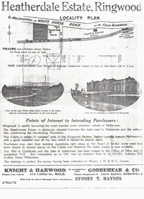
Document, Heatherdale Estate, Ringwood, 1919
Brochure advertising 52 lots, Heatherdale Estate, Ringwood (now Mitcham) to be auctioned September 1919.Brochure advertising 52 lots, Heatherdale Estate, Ringwood (now Mitcham) to be auctioned September 1919. Station Street on the plan is now Victory Street and a Railway Avenue is shown which does not now exist.Brochure advertising 52 lots, Heatherdale Estate, Ringwood (now Mitcham) to be auctioned September 1919.land subdivision, heatherdale estate, whitehorse road, mitcham, melbourne and metropolitan board of works, peers, w.h., coane, j.m., h.e., knight & harwood, godbehear & co, haynes, sydney t, walter street, witt street, victory street, purches, frederick walter -
 Whitehorse Historical Society Inc.
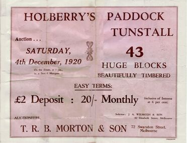
Pamphlet, Holberry's Paddock Tunstall, 1920
Article on development of 30 lot subdivision of former Blackburn East Primary School SiteAuction of Holberry's Paddock, Tunstall - 43 blocks, 4 December 1920. Includes plan.Article on development of 30 lot subdivision of former Blackburn East Primary School Siteshady grove, nunawading, mount pleasant road, holberry street, t. r. b. morton & son, auctions, forest hill holberrys paddock, tunstall -
 Whitehorse Historical Society Inc.
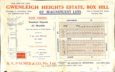
Document, Gwenleigh Heights Estate, Box Hill, unknown
Land plan of 67 allotments for sale between Canterbury Road, Middleborough Road and Agnew Street, Box Hill. (Now Blackburn South)land subdivision, middleborough road, blackburn south, canterbury road, agnew street, aberdeen road, h. v. palmer (estate agent) -
Whitehorse Historical Society Inc.
Article - Newspaper cutting, Subdivision furore, 1994
Vermont South Traders and residents are opposing Shell Australia's plans to subdivide a prominent Nunawading Council owned site on Burwood Highway for a 24 hour petrol station, McDonalds and Video library and cafe.Vermont South Traders and residents are opposing Shell Australia's plans to subdivide a prominent Nunawading Council owned site on Burwood Highway for a 24 hour petrol station, McDonalds and Video library and cafe. Objectors say it is a conflict of interest for the council as the sale of the land is conditional on council approving the subdivision.Vermont South Traders and residents are opposing Shell Australia's plans to subdivide a prominent Nunawading Council owned site on Burwood Highway for a 24 hour petrol station, McDonalds and Video library and cafe.shops, shell australia, city of nunawading, vermont south shopping centre, burwood highway, vermont south, nos 473-493 -
Whitehorse Historical Society Inc.
Document, Heatherdale Road Estate, Unknown
Third subdivision, Heatherdale Road Estate, Mitcham comprising 188 lots. Includes plans, price list and advertising material. 2 copies.brady, john f., heatherdale road, mitcham, purches street, kulnine avenue, culwell avenue, blossom street, nymph street, land subdivision, walwa street -
 Whitehorse Historical Society Inc.
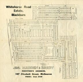
Document, Whitehorse Road Estate
Plan of blocks for sale on the Whitehorse Road EstatePlan of blocks for sale on the Whitehorse Road Estate, Blackburn. 2 copies.Plan of blocks for sale on the Whitehorse Road Estateland subdivision, whitehorse road estate, blackburn, springfield road, goodwin street, surrey road, esdale street, larch street, maple street, musk street, elder street, linden street, elm street, fir street, barnes estate -
 Whitehorse Historical Society Inc.
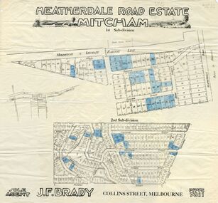
Document, Heatherdale Road Estate, ??
Plans of 1st and 2nd subdivision of Heatherdale Road estatePlans of 1st and 2nd subdivision of Heatherdale Road estate, Mitcham.Plans of 1st and 2nd subdivision of Heatherdale Road estateland subdivision, purches street, mitcham, northcote street, linlithgow street, denman street, fuller street, stanley grove, dudley street, munro street, irvine street, forster street, ferguson street, talbot street, heatherdale road -
Whitehorse Historical Society Inc.
Map, Plan of the Parish of Nunawading, 1853
... , 1853 also Reference to the Corners of allotments' (Plan 428 ...Photocopy of map showing names of selectors, also list of references to the corners of allotments.Photocopy of map showing names of selectors, also list of references to the corners of allotments. Note on verso:'Gardiners Creek, Ballyshanassey township surveyed by H. Parmein, Surveyor General's Office Nov 30, 1853 also Reference to the Corners of allotments' (Plan 428)Photocopy of map showing names of selectors, also list of references to the corners of allotments. land subdivision, gardiners creek, ballyshanassy, parmein, h, burwood east, maps -
Whitehorse Historical Society Inc.
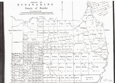
Map, The Parish of Nunawading, 1853
Photocopy of manuscript plan with allotments numbered and some named.Photocopy of manuscript plan with allotments numbered and some named. Note on verso: The Parish of Nunawading in the County of Bourke; lithographed at the Surveyor General's office by J.Jones Jan 18th 1853. Endorsed Sale Plan 271. Dray tracks, water holes and terrain indicated.Photocopy of manuscript plan with allotments numbered and some named. land subdivision, maps, parish of nunawading, jones, j -
 Whitehorse Historical Society Inc.
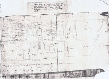
Document, South Riding
Plan showing owners of land in the South Riding of the Shire of NunawadingPlan showing owners of land in the South Riding of the Shire of Nunawading 1888. South Boundary Road is now Highbury RoadPlan showing owners of land in the South Riding of the Shire of Nunawading land subdivision, shire of nunawading. centre riding, dandenong creek, fulton, dr, shire of nunawading. south riding, arundale, w, h. arnold & co. -
 Whitehorse Historical Society Inc.
Document, Plan of Parish of Nunawading, 01/05/1864
Copy of plan of Parish of NunawadingCopy of plan of Parish of Nunawading, County of Bourke, lithographed at the Office of Lands and Survey, Melbourne, 13th May, 1864 showing boundaries of Koonung, Mullum Mullum and Dandenong Creeks.Copy of plan of Parish of Nunawadingland subdivision, parish of nunawading, county of bourke, elgars special survey, koonung creek, mullum mullum creek, dandenong creek -
Whitehorse Historical Society Inc.
Map, Subdivision of Allotment 122a, 1972
Subdivision of land along Livermore Close and Moore Road, Vermont South.Subdivision of land along Livermore Close and Moore Road, Vermont South. Original survey Rob Poole 1899. Stamp indicates 'Land on this plan is in proclaimed survey No 21. Survey Coordination Act 1940. As from 9 Aug 1972. Two maps in different scales.Subdivision of land along Livermore Close and Moore Road, Vermont South. land subdivision, livermore close, vermont south, moore road, vermont south, dandenong creek -
 Whitehorse Historical Society Inc.
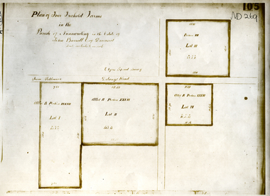
Document, Parish of Nunawading
... ringwood north elgars special survey land subdivision Plan of four ...Plan of four farms in the estate of John BarrattPlan of four farms in the estate of John Barratt on Delaneys RoadPlan of four farms in the estate of John Barratt parish of nunawading, barratt, john, delaney's road, ringwood north, elgars special survey, land subdivision -
 Whitehorse Historical Society Inc.
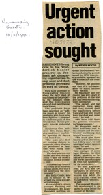
Article, Urgent action sought, 1990
Residents living close to Wunderlich-Monier in Vermont are demanding urgent action to stop noise and dust problems generated by work on the site.Residents living close to Wunderlich-Monier in Vermont are demanding urgent action to stop noise and dust problems generated by work on the site. Town planning services manager of Jones Lang Wootton, Rob McLiver, speaking for the developer said site works had nothing to do with the application for the subdivision, they have approval from the E.P.A. and the Department of Industry.Residents living close to Wunderlich-Monier in Vermont are demanding urgent action to stop noise and dust problems generated by work on the site. tile factories, wunderlich monier -
Whitehorse Historical Society Inc.
Map, Burwood Road, Box Hill City, 15/02/1952 12:00:00 AM
Detailed map of subdivision along the north side of Burwood Road, Box Hill between Station Street and Middleborough Road.Detailed map of subdivision along the north side of Burwood Road, Box Hill between Station Street and Middleborough Road. Shows many block owners, types of buildings, nature of fencing. Marked as 'Survey Plan No 5440'.Detailed map of subdivision along the north side of Burwood Road, Box Hill between Station Street and Middleborough Road. maps, burwood road, burwood, andrews street, greenwood street, tennyson street, middleborough road, station street -
 Whitehorse Historical Society Inc.
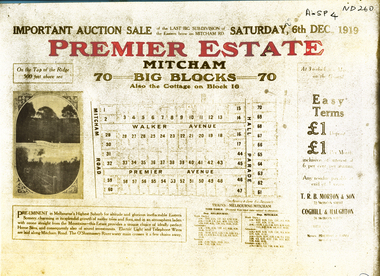
Document, Premier Estate, 1/11/1919 12:00:00 AM
Plan of Premier Estate Mitcham.Plan of Premier Estate Mitcham. Subdivision including lots in Mitcham road, Premier Avenue, Halls Parade, Walker Avenue. Auction 6/12/1919Plan of Premier Estate Mitcham. mitcham road, mitcham, premier avenue, walker avenue, halls parade, premier estate -
 Whitehorse Historical Society Inc.
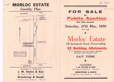
Document, Morloc Estate
Advertising brochure, including plan of landAdvertising brochure, including plan of land for sale in Morloc Estate, Nunawading off Springvale RoadAdvertising brochure, including plan of land morloc estate nunawading, land subdivision, springvale road, nunawading -
 Whitehorse Historical Society Inc.
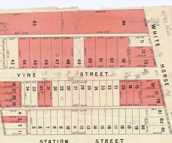
Document, Plan of Blackburn
Copy of plan of Blackburn areaCopy of plan of Blackburn area bounded by Whitehorse Road, Station Street and Railway ParadeCopy of plan of Blackburn arealand subdivision, blackburn, whitehorse road, station street, railway road, vine street -
 Whitehorse Historical Society Inc.
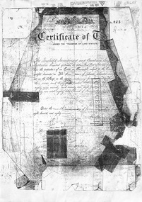
Document, Blackburn, 1/08/1995
Photocopy of Certificates of Title Vol 2105 Fol 420823 being 480 acres, part Crown Portions 81, 82, 89, 90, and 91 to Freehold Investment and Banking Co of Australia Limited, 9 January 1889. Includes plan of the area bounded by Central Road, Blackburn Road and Stanley Road, (now Wellington Avenue) Blackburn and transfers 1890 - 1926.land subdivision, central road, blackburn, blackburn road, gordon crescent, stanley grove, quarterman, martha, clarke street, grieve, robert, brown, james, game, kate, lincolne, phyllis marian, richardson, william wheeler, wellington avenue, thomas robinson -
Whitehorse Historical Society Inc.
Document, 520 Mitcham Road, 2005
... properties; plan of 1906 subdivision; ASIC extract of development... and adjacent properties; plan of 1906 subdivision; ASIC extract... and adjacent properties; plan of 1906 subdivision; ASIC extract ...Papers relating to objections to development of 520-528 Mitcham Road Mitcham.Papers relating to objections to development of 520-528 Mitcham Road Mitcham. Includes: statement by Neil Edwin Kerby & Margaret Anne Kerby; Title searches for 449 Mitcham Road Mitcham and adjacent properties; plan of 1906 subdivision; ASIC extract of development company organisational details; aerial photos of the area; photographs of nearby properties and of Mitcham Road streetscapes and list of Mitcham objectors. CD copy at NP3771Papers relating to objections to development of 520-528 Mitcham Road Mitcham. mitcham road mitcham, nos. 520-528, kerby, neil edwin, kerby, margaret anne, mitcham road mitcham no. 449, 520 mitcham road pty ltd, listermay nominees pty ltd, land subdivision -
Whitehorse Historical Society Inc.
Article, Panel takes up fight, 1997
Article on opposition to a planned development at 456 Mitcham Road, by Friends of Walker Estate.Article on opposition to a planned development at 456 Mitcham Road, by Friends of Walker Estate.Article on opposition to a planned development at 456 Mitcham Road, by Friends of Walker Estate.city of whitehorse, friends of walker estate, mitcham road, mitcham, no. 456, land subdivision -
Whitehorse Historical Society Inc.
Document, Dual Occupancy, 9/09/1992
... Mitcham melbourne Land Subdivision City of Nunawading. Planning ...Dual Occupancy Guidelines 1993 amended 4.5.93 City of Nunawading Planning and Development 9 September 1992land subdivision, city of nunawading. planning and development department, abbott, kevin -
Whitehorse Historical Society Inc.
Document, Multi Unit Development Policy, 1993
Multi Unit Development Policy: City of Nunawading Planning and Development Departmentcity of nunawading planning and development department, land subdivision, abbott, kevin -
Whitehorse Historical Society Inc.
Map, Parkmore Estate, c1958 - 1959
... Plan of 'Parkmore' subdivision by Southern Construction... Mitcham melbourne Land Subdivision Forest Hill Parkmore Road ...Plan of 'Parkmore' subdivision by Southern Construction Company, 444 lots, c 1958-59.land subdivision, forest hill, parkmore road, forest hill, ranfurlie road, forest hill, ranfurlie court, forest hill, everglade avenue, forest hill, hampshire road, forest hill, quentin street, forest hill, cedar court, forest hill, martin court, forest hill, wandin court, forest hill, inglewood avenue, forest hill, deauville street, forest hill, oberon street, forest hill, vanbrook street, forest hill, husband road, forest hill, springvale road, forest hill, southern construction company -
Whitehorse Historical Society Inc.
Map, Anjaya Court, Blackburn, ca1970
... Mitcham melbourne Anjaya Court Blackburn Land Subdivision Sewerage ...[Plan of] Anjaya Court, Blackburn, Lots 6 - 20and of Leons Court, Lots 21-24. One copy with proposed sewerage plan.anjaya court, blackburn, land subdivision, sewerage and sanitation -
Whitehorse Historical Society Inc.
Map, Township of Norwich, ca 1850
Plan of the Township of Norwich being subdivision of Section III, Parish of Nunawading, County of Bourke, consisting of suburban farms, vineyard sites and town lots, for sale by auction by W. Casey & Co. [c. 1850]. Original in Vale Maps Collection, La Trobe Library.norwich village, vermont, parish of nunawading, vermont south, maps -
 Whitehorse Historical Society Inc.
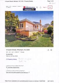
Document - Various including maps, titles, posters, Land ownership of 4 Austin Street, Mitcham, 1873 - 2019
Ownership history of 4 Austin Street, Mitcham.Ownership history of 4 Austin Street, Mitcham between 1873 to 2019, including the plan of the Mellorton Estate, Mitcham (1923), showing some lots priced at one hundred and forty-five pounds and the Charlesworth Estate ((1913). The Austin Street house was purchased by Martin and Shirley Gleeson 1956 and sold in 2019. Subdivision map of area south of Burnett Street to Harrison Street. non-fictionOwnership history of 4 Austin Street, Mitcham.drake real estate, charlesworth estate mitcham, mellorton estate mitcham, austin street mitcham no4, ainger frank