Showing 39151 items
matching surveyors-camp-east-gippsland
-
 Lakes Entrance Historical Society
Financial record - Ledger, Country Roads Board Wages Ledger, 1953
A Ledger of Wages paid to Country Roads Board employees of East Gippsland VictoriaA Ledger of Wages paid to Country Roads Board employees of East Gippsland Victoriaaccounts book -
Tatura Irrigation & Wartime Camps Museum
Photograph, Camp 3 Band, 1945
Photo taken in Camp 3, and donated to Museum by "Wally" Wagner.Sepia photo pasted to foam core backing showing three men- kettle drum, flute & cello, lady ("Wally") with piano accordian.On backing- Camp 3 Band- "Wally" Wagner, piano accordianist (later "Liebeskind" Sydney NSW.)camp 3, music, photography, photograph, slides, film -
 Orbost & District Historical Society
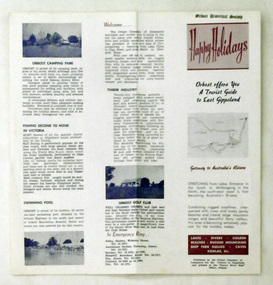
pamphlet, Snowy River Mail, Happy Holidays
This pamphlet was probably produced for use in the Slab Hut (Orbost Visitor Information Centre)These pamphlets are useful reference tools and reflect the tourism history of the local area.Two single page tourist brochures, printed on both sides and folded in the middle. They are white with pink and blue print. and have a map of East Gippsland and descriptions of places to visit.tourism-orbost -
 Lakes Entrance Historical Society
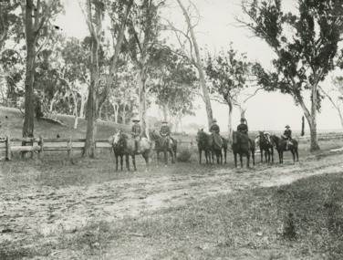
Photograph - Howitt family/Tarli Karng Expedition
Black and white photograph of five people on horseback with three pack horses identified as Howitt family A W Howitt, Annie Howitt, Mary Howitt East Gippsland VictoriaExpedition to Tarli Karng 'Setting Out'people, genealogy, local history, expedition -
 Lakes Entrance Historical Society
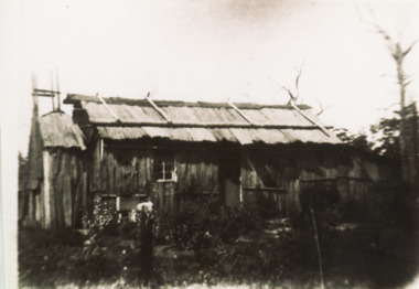
Photograph - Settlers' Dwelling, 1880 - 1890 c
Black and white photograph of pioneer iron bark slab hut typical of early settlers dwellings with chimney and skillion at end with early garden shown East Gippsland Victoriasettlement, housing -
Phillip Island and District Historical Society Inc.
Book, Broadbent's Official Road Guides Company, Broadbent's official guide : Gippsland and south-east corner of N.S.W. incorporating large scale maps, 1950
J.P. Anderson, 97 Salmon St., Hastings'victoria, guidebooks -
 Victorian Aboriginal Corporation for Languages
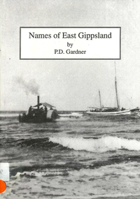
Book, P D Gardner, Names of East Gippsland : their origins, meanings and history, 1992
Detailed examination of the origins of local names from Mallacoota to Marlo and from Wingan Inlet to Willis. Includes explanations of the origins of major towns and their features.Maps, b&w illustrations, b&w photographskrauatungalung, gunnai, kurnai, bidawal, east gippsland, lake tyers, point hicks, -
Lakes Entrance Historical Society
Memorabilia, Early Farming Scenes of East Gippsland, 1985
Calendar issued as part of Victorian 150th Anniversary celebrations1986 Calendar, beige coloured plastic cover with white spiral bound plastic spine, photo on front cover is of Bullock Team carting a wagon with wool balesdocuments, calendars -
Lakes Entrance Historical Society
Book, East Gippsland National Estate Report, 1996
109 printed pages, plastic envelope containing maps inside rear cover, spiral wire boundBuff coloured cover with leaf pattern, left side of cover is brown, rear cover is monotone buff.documents, reports -
Lakes Entrance Historical Society
Book, Vantree Pty Ltd Shearwater Environmetal Management, East Gippsland - Creating a Community Heritage Plan, 2002
This plan provides for the long-term Coastal Action Planwaterways, environment, tourism, boats and boating -
Lakes Entrance Historical Society
Book, Rule, Hilda, East Gippsland Past and Present, 1980
History of Nowa Now for the 'Back to Nowa Nowa' in September 1980. Includes photographs.township, timber industry, settlement -
Koorie Heritage Trust
Book, O'Bryan, Denis, Pioneering East Gippsland, 1983
East Gippsland61 p.; maps; ill.; 20 cm.East Gippslandvictoria. east gippsland region, to date. | gippsland (vic.) -- history. -
Koorie Heritage Trust
Book, Back to Bairnsdale Committee, Past pictures and poems of East Gippsland : a pictorial and poetic history to commemorate the Back-to-Bairnsdale Celebrations, 1993, 1993
98 p. : ill. ; 22 cm.east gippsland (vic.) -- poetry. | east gippsland (vic.) -- history -- pictorial works. -
Koorie Heritage Trust
Book, Beauglehole, A. C, The distribution and conservation of vascular plants in the East Gippsland area, Victoria, 1981
iv, 124 p. : ill., maps (some col.) ; 22 x 30 cm.indigenous vascular plants. distribution. victoria. gippsland. | botany -- victoria -- gippsland. -
Lakes Entrance Historical Society
Book, Johnston Chris, Nowa Nowa Workshop Report East Gippsland Heritage Workshop, 1993
Report on 1993 heritage workshop condcted at Nowa Nowa, Victoria where 97 historic areas and cultural landscapes were identified.heritage, social history -
Lakes Entrance Historical Society
Book, Campbell Kenneth W, 100 Years of Saints and Sinners The Centenary History of the Anglican Parish of Bruthen in East Gippsland, 1992
A centenary history of St Matthews Anglican Parish of Bruthen,Victoria which includes history and development of the region, establishment of the Church, priests and lay readers, and the other communities served, ie Sarsfield, Wiseleigh, Mossiface, Tamboreligion, township -
Lakes Entrance Historical Society
Book, Land Conservation Council Victoria, Land Conservation Council East Gippsland Area Review, 1985
Report describing the physical and biological aspects of the public land in the eastern corner of Victoria, predominantly the Orbost Shire. Many issues are covered in the report, including timber industry, national parks, waterways and tourism. Six mapsparks, waterways, tourism, gippsland -
Lakes Entrance Historical Society
Book, Past Pictures and Poems of East Gippsland, 1993
An anthology of poems by local people, illustrated with photographs, compiled for the 'Back to Bairnsdale' celebrations in 1993. Facts are not resourced, captions are known to be suspect.celebrations, land settlement, township -
Lakes Entrance Historical Society
Book, Context Pty Ltd, East Gippsland - Creating a Community Heritage Plan, 2000
Report on the heritage workshop held at Lakes Entrance on 1st.June 2000, when a draft Community Heritage Plan was developed to be presented to the Shire.heritage, history, settlement -
Lakes Entrance Historical Society
Book, Catherine Larkins, Farming in East Gippsland, 2013
Proceedings of the farming seminar held as part of 150th aniversary celebratins Brainsdale Victoriafarm, irrigation -
Lakes Entrance Historical Society
Book, Streeter Neil and Battista Marlene, East Gippsland Rail Trail Concept Plan, 1987c
Concept plan for establishment of rail trail on disused railway reserve Bairnsdale to Orbost.recreation -
Lakes Entrance Historical Society
book, Davies Judy, East Gippsland ANZACS, 2016
Stories of those who served in World War 1 Service medals and decorationsworld war 1914-1918 -
Lakes Entrance Historical Society
Book, Joint Commonwalth Forests Steering Committee, East Gippsland Forest Agreement Consultation Paper 2000, 2000
Prepared by the joint Commonweath and Victoria regional forest agreement steering committee Barton ACTenvironment, forest, wool industry -
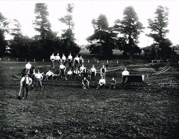
 Kiewa Valley Historical Society
Black and white photograph of Surveyor's Camp, 1938, Kiewa River and surveyor's Camp 25/8/38, 25/08/1938
Surveying under the prevailing conditions at this time was an arduous and demanding task. There were no roads beyond Tawonga and access was by bridle tracks, on foot or horseback. This camp was to provide accommodation to those men who were surveying the road from South Tawonga to the Bogong High Plains which was commenced in April, 1938. The actual work was undertaken by the Country Roads Board, on behalf of the State Electricity Commission, using three Caterpillar diesel crawler tractors equipped with Kay Bruneriei (Brunner) lhydraulically operated trailbuilders (angle dozers)This photograph shows the primitive living conditions that were endured by those carrying out the initial field investigations and surveys for the Kiewa Hydro Electric Scheme. It is possibly one of the few photographs in existence of this camp and of the very rustic timber foot bridge across the West Kiewa river. It has been taken from approx. 100m up Simmonds Creek Road. A black and white photograph showing a small, timber foot bridge across the West Kiewa River. There is a man standing on the bridge and two small huts on the far side of the river, against a backdrop of Mt. Beauty and Mt. Bogong.At the top of the photograph, handwritten in black ink is the inscription "Kiewa River and Surveyor's Camp 25/8/38". The number 4 is stamped towards the right upper corner. On the back, in a circle, about 1.3cm in diameter, are the words "Kodak Print". The word "Velox" is faintly discernible on the back as well.surveyor, tawonga, west kiewa river, bridge, camp, secv -
Tatura Irrigation & Wartime Camps Museum
Folder, POW Camp 13
Photos held by Keith Gregory of Murchison. Camp 13 under construction.Blue multi ring plastic folder with plastic sleeves containing photos.POW Camp 13 Murchison Army photographs purchased from Keith Gregory Murchison 1994camp 13 construction, keith gregory -
Federation University Historical Collection
Booklets, Gippsland Institute of Advanced Education External Studies, 1976-1984
Federation University Australia was established on 1 January 2014. Formerly known as the University of Ballarat, its enabling legislation was the University of Ballarat Amendment (Federation University Australia) Act 2013. Although formally created as a University in 1994, the University of Ballarat had a lineage back to 1870 with the establishment of the School of Mines Ballarat, making it the third institution of higher learning to be established in Australia and the first to be established in regional Australia. On 1 January 1994, Ballarat University College became the University of Ballarat and in 1998 the University merged with three TAFE Institutes to become a dual sector institution with multiple campuses. On 1 January 2014, the University of Ballarat amalgamated with the Monash University Gippsland Campus to form Federation University Australia. The Gippsland Campus also had a long lineage dating back to 1928 with the establishment of the Yallourn Technical School which became a predecessor institution to the Gippsland College of Advanced Education formed in 1968. In 1990, it was renamed the Monash University College and in 1993 became the Gippsland Campus of Monash University. Federation University Australia, or FedUni, is Australia’s newest public University. Headquartered in Ballarat, Victoria, the University offers programs in Higher Education and Vocational Education and Training to regional Victoria and beyond. The University’s commitment to educational and social equity, teaching excellence, research distinction, environmental sustainability and regional capacity building has enabled it to develop in a way that draws on its proud heritage to inform its future. Its regional character sets a framework for the University’s priorities but does not constrain it from serving wider community interests, nationally and internationally. With campuses from Horsham in the west of the state, to Churchill in the east, the name Federation University Australia was chosen to convey the scope and capacity of an expanded regional university with a federated network of campuses contributing to a new and different Australian university.5 booklets outlining external studies at the Gippsland Institute of Advanced Education. Staffmembers of particular courses are given. .1) 1976 (white) .2) 1977 (white) .3) 1982 (white) .4) 1983 (brown) .5) 1984 (blue)gippsland institute of advanced education, churchill, gippsland campus, keith hamilton, a. marianne robinson, andrea devent, peter harwood, alan maclaine, graham dettrich, leslie g. gordon, ethel ruymaker, kevin hince, william battersby, ann hodgkinson, eric thorne, john etheredge, v.g. venturini, rhonda jacobs, peter farago, asim kumar pal, martin hooper, jeffrey dowsley, neil clutterbuck, john yocklunn, janet martin, neil grant, michelle harris, felicetta kille, jennifer hill, john levans, clive vernon, peter charles -
 Otway Districts Historical Society
Photograph, Narrow gauge construction camp near Colac, c.1900
Construction of the Colac-Beech Forest railway line commenced in 1900 and the first activities were the work gangs and their camps. About 100 men were engaged in laying and ballasting the track while others formed the earthworks and the building of culverts and bridges. The first camp was established eight kilometres from Colac, the second 12 km south, and the remainder spaced at similar distances as the work progressed. The camps were served by butchers and bakers from Colac that visited them as many times each week to satisfy the mens' requirements. Many of the men had their families with them. They all lived in tents that consisted of a wooden floor around which the canvas cover was built. A calico partition divided the eating and sleeping quarters, and all cooking was done in camp ovens or at open fires.B/W. 158mm x 203mm. Near Colac, a narrow gauge construction camp comprising 21 workmen, a horse, and two tipping trays.construction camp; railways; colac; -
Bialik College
Photograph (Item) - Student camp photographs, Student camp photographs_Gideon Borden
Photographs taken during a student camp at Bialik College Please contact [email protected] to request access to this record. Nonebialik college, camp, outdoor education -
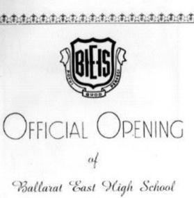 Ballarat Heritage Services
Program, Ballarat East High School, Official Opening Program, 1961, 1961
Ballarat East High School Official Opening Programballarat east high school, opening, education -
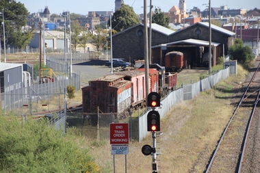 Ballarat Heritage Services
Photograph - Colour, L.J. Gervasoni, Ballarat East Station, 2016, 15/05/2016
Colour photographs showing Ballarat East Railway station.ballarat east railway, ballarat