Showing 1860 items
matching the rock
-
 Nillumbik Shire Council
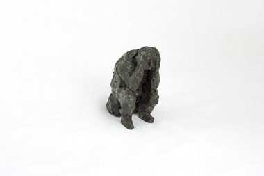
Sculpture: Peter WEGNER (b.1954 NZ - a.1958 AUS), Peter Wegner, Disbelief (from the 'Black Saturday' series), 2010
The 'Black Saturday' bushfires were a series of bushfires that ignited across the Australian state of Victoria on and around Saturday, 7 February 2009. It was Australia's worst ever natural disaster. The fires occurred during extreme bushfire-weather conditions and resulted in Australia's highest ever loss of life from a bushfire: 173 people died and 414 were injured as a result of the fires.This work is by a local contemporary artist with a national and international reputation for figurative and portrait works. The 'Black Saturday' series is a powerful investigation of emotion and grief as experienced by many Nillumbik residents during the 2009 'Black Saturday' bushfires. A cluster of bronze figurines either stand alone or embrace in groups. Their expressions and gestures of despair are made more pertinent with the raw like application and surface treatment of the material used. The 'Black Saturday' series is a challenging work, but one that encourages healing, connection and empathy. Solitary figure sitting on rock/log with elbows resting on knees and hands on head. Face looking down in despair. Surface treatment is textured. Dark metallic brown colour with figure starting to turn a green patina.Sticker underside of sculpture 'No. 205640 (AP)'wegner, figurine, bronze, black saturday, sculpture -
 Mt Dandenong & District Historical Society Inc.
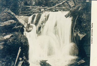
Photograph, Lower Olinda Falls
Copy of a postcard labelled Lower Olinda Falls. There is an original postcard in the collection depicting the same image but with a young man sitting on a rock upper LHS. That postcard identifies the area as Upper Olinda Falls - which is correct.Printed on front: Lower Olinda Fallsolinda falls, lower olinda falls, upper olinda falls, olinda -
 Kew Historical Society Inc
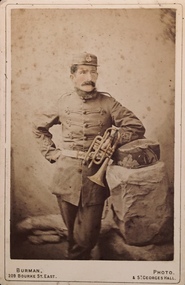
Photograph - Orlando Henry Beater Christian, 1860
An item from an outstanding and diverse photographic collection, assembled by members of the Christian and Washfold families of Kew.Three quarter length sepia studio portrait of Orlando Henry Beater Christian in uniform holding a cornet. He wears a cap and is posed with the cornet in his left hand, leaning on a cushion atop a fake rock.hawthorn band, orlando henry beater christian, christian-washfold collection -
 8th/13th Victorian Mounted Rifles Regimental Collection
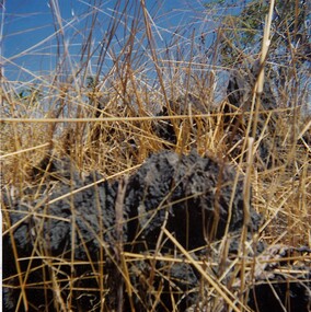
Photograph
In 1988, as part of a Defence of Mainland Australian policy, defence of facilities of strategic importance in northern Australia were allocated to Army Reserve units. ‘A’ Squadron was allocated the defence of Tindal Air Force base located 15 KM outside Katherine in Northern Territory. Consequently the Squadron deployed on Exercise ‘Northern Explorer’ to gain first-hand knowledge of operating conditions for mounted and dismounted patrolling in the area.Colour photograph of jaggered basalt rock covering most of high country SSW of Tindal RAAF Base, Northern Territory. Photo was taken to illustrate reports of patrols during Exercise " Northern Explorer" September 1988. -
 Lakes Entrance Regional Historical Society (operating as Lakes Entrance History Centre & Museum)
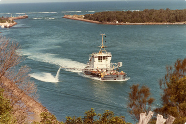
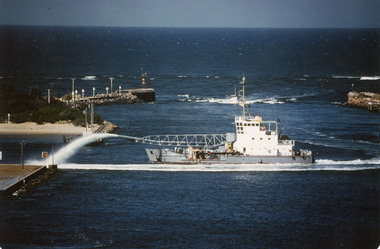
Photograph - April Hamer, Fraser, Ian, 1980 c
Colour photograph of the sand dredge, April Hamer, working inside the entrance off Bullock Island. Ocean in background, rock groynes of the entrance visible, a fishing boat coming through the entrance. Lakes Entrance Victoriawaterways, dredging -
 Lakes Entrance Regional Historical Society (operating as Lakes Entrance History Centre & Museum)
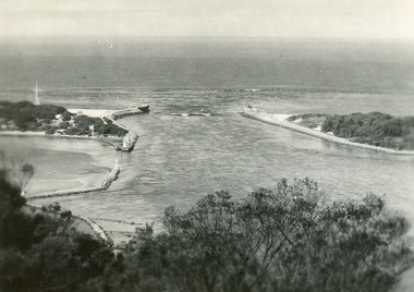
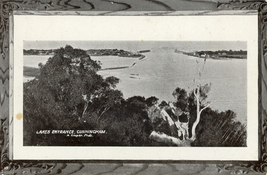
Postcard - The Entrance, 1940c
Black and white small format postcard of the man-made entrance to the Gippsland Lakes taken from Jemmys Point. It also shows the rock groynes at Bullock Island and entrance to Cunninghame Arm. Lakes Entrance Victoriawaterways, topography -
 Eltham District Historical Society Inc
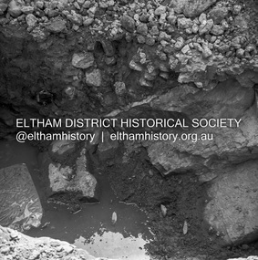
Negative - Photograph, J.A. McDonald, Heidelberg-Kinglake Road, 3 Nov. 1959
Job 56M431 Rock strata foundations This is what the bridge is founded on downstream side Kinglake abutment November 1959 Contractor W.E. WolfRecord of various Shire of Eltham infrastructure works undertaken during the period of 1952-1962 involving bridge and road reconstruction projects, sometimes with Eltham Shire Council Project Reference numbers quoted. It was during this period that a number of significant improvements were made to roads and new bridges constructed within the shire that remain in place as of present day (2022). In many situations, the photos provide a tangible visible record of infrastructure that existed throughout the early days of the Shire. The album was put together by or under the direction of the Shire Engineer, J.A. McDonald.infrastructure, shire of eltham, bridge construction, heidelberg-kinglake road, road construction, yow yow creek, 1959-11 -
 Eltham District Historical Society Inc
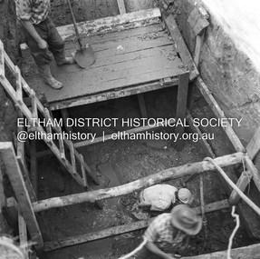
Negative - Photograph, J.A. McDonald, Henley Road at Watsons Creek, Apr. 1961
Henley Road at Watsons Creek showing excavation at western pier Rock at contract level, slight underground flow Early April 1961Record of various Shire of Eltham infrastructure works undertaken during the period of 1952-1962 involving bridge and road reconstruction projects, sometimes with Eltham Shire Council Project Reference numbers quoted. It was during this period that a number of significant improvements were made to roads and new bridges constructed within the shire that remain in place as of present day (2022). In many situations, the photos provide a tangible visible record of infrastructure that existed throughout the early days of the Shire. The album was put together by or under the direction of the Shire Engineer, J.A. McDonald.infrastructure, shire of eltham, bend of islands, cr. charis pelling, henley road, henley road bridge, kangaroo ground, oxley bridge, watsons creek, w.e. wolf, bridge construction, road construction, 1961-04 -
 Stawell Historical Society Inc
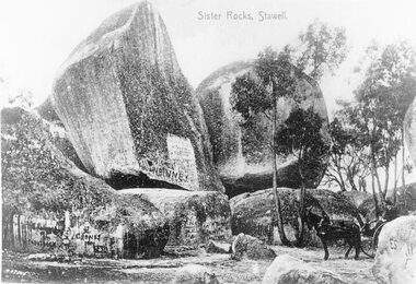
Photograph - Postcard, Sister Rocks Stawell, C 1900
View of Sister's Rock's looking East. To the right in the photo is a horse and person on the buggy. Graffiti is covering the lower sections of the rocks. c 1900.Copy of postcard of Sister Rocks with a person man sitting on horse & buggy. Two copies of the postcard.Sister Rocks, Stawell.tourism -
 Stawell Historical Society Inc
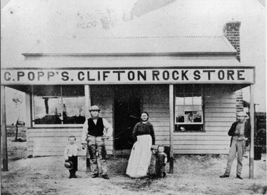
Photograph, Mr C. Popp’s Clifton Rock Store on the the corner of Newington Road and Sophia Street Stawell
... Mr C. Popp’s Clifton Rock Store on the the corner of ...C. Popp’s Clifton Rock Store simple wooden cottage with verandah across front. Located at corner of Newington Road and Sophia Street.stawell -
 Federation University Historical Collection
Journal, Donald Douglas Mather, Exercise Books used for Newspaper article notes, 1954
Blue covered embassy exercise book of lined paper with handwritten notes inside and some loose notesHandwritten on front cover. From Donald Douglas Mather Rock St, Ivanhoe, Victoria. Ballaarat of Historical Society, Australian History from 1512 to 1890 to Keith Rash August 1968. buninyong gold fields, melbourne morning herald, melbourne argus, dunlop and regan, ballarat gold diggings, melbourne news, donald douglas mather, keith rash, james jones, gold discovery -
 Stawell Historical Society Inc
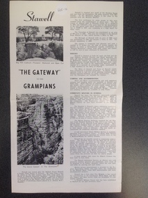
Book, Stawell "The Gateway to the Grampians", 1988
Stawell Tourist InformationA Page folded in half to make 4 pages with large print and small print split into two columns as well as two photographs on the right side"Stawell" with Two photographs showing Pioneer's Lookout on Big Hill. " "The Gateway" to the Grampians" above the other Photograph which shows a rock formation known as The Grand Canyon. which is located in the Grampians.stawell tourism -
 Melbourne Tram Museum
Ephemera - VR 6d - Sandringham - Beaumaris - Motor Coach, Victorian Railways (VR), c1956
Ticket issued by the Victorian Railways for the Motor Coach (bus) replacement service on the former Sandringham to Beaumaris tram route. Issued for sections 1 to 4, price 6d. Note: The ticket number is also printed on the top or stub of the ticket. This section would normally be retained on the stub itself. The section of tram line from Black Rock to Beaumaris closed in 1931 and the section from Sandringham to Black Rock closed in 1956.Demonstrates the type of ticket used on the replacement Sandringham to Beaumaris bus service.Ticket - off white paper, black printing with green price - No. 126123vr, victorian railways, tickets, sandringham, beaumaris, buses -
 Melbourne Tram Museum
Document - Report, David Frost, Sale of 33 Fifth St Black Rock - tram shed
Documents related to the sale of 33 Fifth Street Black Rock, including two colour photocopies with the external and internal views of a shed said to be a former tram shed associated with the Sandringham to Black Rock horse tram line. Includes the City of Bayside heritage report and Hocking Stuart sales sheets for an auction on Saturday 4 August 2007. It would appear from Google Earth that all buildings were demolished.Yields information about the sale of a property said to be associated with the Black Rock tramway.Four A4 sheets - two colour and one colour sheet providing auction details.trams, railways, vr trams, sandringham, black rock tramway, sale of land, 33 fifth st black rock -
Southern Sherbrooke Historical Society Inc.
Information folder - Grace Vosper
Research carried out to ascertain history of sampler donated to Southern Sherbrooke Historical Society by Helen Gibson.Folder containing information pertaining to Grace Vosper, creator of the sampler now hanging in the original St Martins Anglican Church, Belgrave Heights, Victoria. Contents: -marriage certificate, Dennis Rock and Grace Vosper, 1st September 1855, Melbourne, Victoria -family tree, showing descendants of Grace & Dennis Rock, hand-written -printed Register chart, William Vosper, showing descendants -printed Descendancy chart, William Vosper, showing descendants -printout, 1881 British Census, Vosper family members (2 sheets)vosper, grace, vosper family, rock family, gibson, helen, original st martins church, southern sherbrooke historical society -
 Halls Gap & Grampians Historical Society
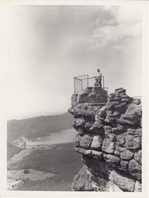
Photograph - B/W, C 1960s
Photo is of 'The Pinnacle' lookout with Lake Bellfield in the background flanked by the Mt. William range. the photo is typical of 'tourism' photos taken by the Victorian Railways.Photo shows a man and a woman on top of a rocky outcrop that overlook a valley. A lake with a dam wall and rock tiers cut into the hillside can be seen as well as cleared areas some buildings. the lookout is enclosed with a wire fence.scenery, lookouts -
Glenelg Shire Council Cultural Collection
Photograph - Photograph - Main Breakwater Construction, n.d
Port of Portland Authority Archivesport of portland archives -
 Bendigo Historical Society Inc.
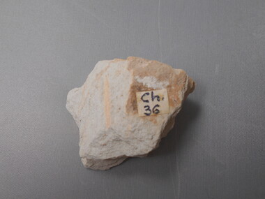
Geological specimen - GRAPTOLITE COLLECTION: PHYLLOGRAPTUS AUGUSTIFOLIUS (J. HALL 35084) CHEWTONIAN
Phyllograptus Augustifolius, Figured by E.A. Ripper. White coloured rock, one-stipe graptolite specimen. Sticker with 'CH 36' near specimen. Graptolite specimen was formerly held in the School of Mines Museum, Pall Mall, Bendigo. -
 Bendigo Historical Society Inc.
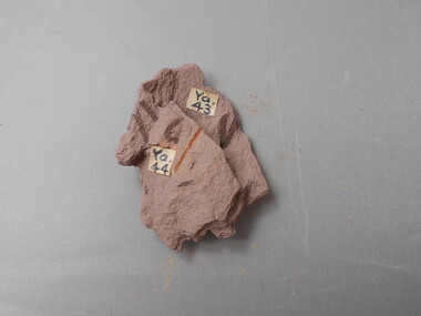
Geological specimen - GRAPTOLITE COLLECTION: ISOGRAPTUS MANU BRIATUS T.S.H
Isograptus manu briatus T.S.H, Yapeenian. Pinkish coloured rock, one whole and parts of other graptolite specimens visible. 'Ya44" on sticker Fossil collection was formerly held by the School of Mines Museum, Pall Mall, Bendigo. -
 Bendigo Historical Society Inc.
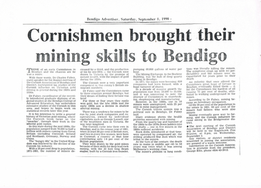
Newspaper - LONG GULLY HISTORY GROUP COLLECTION: CORNISHMEN FROUGHT THEIR MINING SKILLS TO BENDIGO
Copy of an article from the Bendigo Advertiser 1/9/1990 mentioning the Cornish influence on Victorian gold mining during the 1880's and 1890's. Also mentioned is population growth, rock drills and miner's phthisis.bendigo, history, long gully history group, the long gully history group - cornishmen brought their mining skills to bendigo, bendigo advertiser 1/9/1990, dr charles fahey, cornish association of bendigo and district, bendigo college of advanced education, george lansell, the mining exchange, beehive building, eaglehawk fire station, george ellis -
Tatura Irrigation & Wartime Camps Museum
Photograph, 1936
Photo taken by the photographer for Victoria State Rivers and Water Supply CommissionMedium sized black and white photograph. Eildon Reservoir dam wall / rock and earth fill wall from above / round concrete tower lower left / water above right / tree covered hill topgoulburn, irrigation, photo, victoria state rivers and water supply commission, eildon, eildon weir -
 Hume City Civic Collection
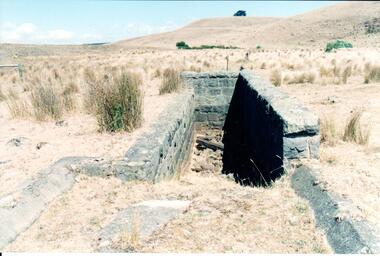
Photograph, Early 1990's
This is a photograph of one of the many stone ruins which can be seen in the Sunbury area and surrounding districts. These ruins are found in varying degrees of structural damage caused by erosion, vegetation growth and vandalism. The bluestone structure was a sheep dip on the 'Karoora Park' property near Jacksons Creek.A coloured photograph of the stone remains of a sheep dip constructed from basalt rock. The ground at the entrance slopes down into a narrow walled channel. The surrounding paddocks are covered with tussocks of grass and there are bare hills in the background. The grass is brown.stone structures, sheep dips, basalt rock, 'karoora park', george evans collection -
 Lakes Entrance Regional Historical Society (operating as Lakes Entrance History Centre & Museum)
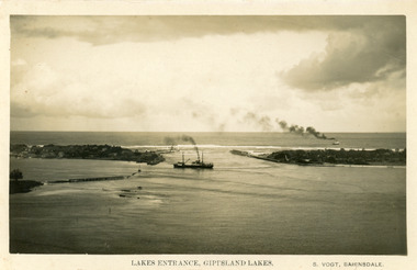
Postcard - S.S. Wyralla. S.S. Manawatu, 1920 c
Also other copies purchasedBlack and white postcard showing view of the entrance, with S S Manuwatu, and S S Wyralla at sea, timber entrance groynes visible, rock and timber groynes to form Bullock Island visible. Lakes Entrance Victoriaships and shipping, jetties, waterways -
 Lakes Entrance Regional Historical Society (operating as Lakes Entrance History Centre & Museum)
Photograph - April Hamer, Fraser, Ian, 1980 c
Colour photograph of side casting sand dredge, April Hamer, working in the channel below Kalimna Hill inside the entrance from Bass Strait. Ocean in background, rock groynes of the entrance visible. Lakes Entrance Victoria waterways, dredging -
 Lakes Entrance Regional Historical Society (operating as Lakes Entrance History Centre & Museum)
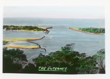
Postcard - The Entrance, Bulmer H D, 1940c
Hand tinted small format postcard of the entrance to the Gippsland Lakes, taken from Jemmys Point. It shows the rock groynes at Bullock Island with dredged sand filling the basin between island and groyne. Lakes Entrance VictoriaThe Entranceislands, waterways, topography -
 Lakes Entrance Regional Historical Society (operating as Lakes Entrance History Centre & Museum)
Postcard - The Entrance, 1905c
Message on back of card, to 'Misses M & A Henderson, Swan Reach, Just a line to wish ......, Yours sincerely, R J Gilsenan.'Black and white postcard of the man made entrance. It shows the works building and cottages on each side of the entrance, timber cribs and rock groynes at Bullock Island, natural vegetation of Jemmys Point in foreground. Lakes Entrance VictoriaLakes Entrance, Cunningham topography, waterways, correspondence -
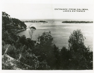 Lakes Entrance Regional Historical Society (operating as Lakes Entrance History Centre & Museum)
Postcard - The Entrance, 1935c
Also 2 identical small format postcardsBlack and white small format postcard taken from the cliff top at Kalimna. It shows the man made entrance through the hummocks, rock groynes, Jemmys Point cliff and natural vegetation in foreground. Lakes Entrance VictoriaEntrance from Kalimna, Lakes Entrance waterways, topography -
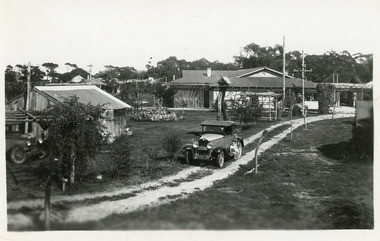 Lakes Entrance Regional Historical Society (operating as Lakes Entrance History Centre & Museum)
Postcard - Lakes Camping Park, Whiters Camp Park, 1932
Black and white postcard of the Homestead at Whiters Camp Park. Also shown is a cabin with water tank, rock garden, single seater roadster parked on track with two small children on running board. Lakes Entrance Victoriacamping, tourism, transport, caravan parks -
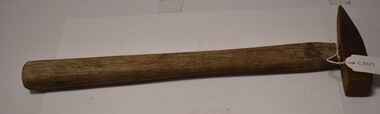 Tatura Irrigation & Wartime Camps Museum
Tool - Hammer, 1940's
Made by internees at camp 3, using wood sourced from under the barracks ie : stumps. Tapered head used in blacksmithing or for rock chippingHammer medium size, metal head, wooden handle, pointed on one end and square on the other. Handle thick at bottom end and tapered at top where head fits on.kazenwadel, blacksmith, wood, tools camp 3, metal -
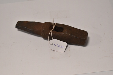 Tatura Irrigation & Wartime Camps Museum
Tool - Hammer head, 1940's
Made by internees at camp 3, using wood sourced from under the barracks ie : stumps. Tapered head used in blacksmithing or for rock chippingMedium size hammer head made from metal. Square at one end and tapered at other. Hole in middle for handle. No handle.kazenwadel, blacksmith, wood, tools camp 3, metal