Showing 112993 items
matching tracks/roads
-
 Kew Historical Society Inc
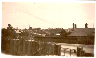
Photograph - Corner of Normanby and Parkhill Roads, Kew, 1926
The section of Normanby Road, Kew from Cotham Road to Parkhill Road was officially gazetted in 1865. The part of Normanby Road between Parkhill Road and Harp Road was gazetted ten years later in 1875. Parkhill (sometimes Park Hill) Road East and Parkhill Road West were both gazetted in 1865.Original, black and white positive print of a photograph taken from a house in Normanby Road across the road to another house on the corner of Normanby and Parkhill Roads. The hills of Kew can be seen in the background. The main house in the photo is 57 Normanby Road.Inscribed verso: "Normanby Rds and Parkhill Rds corner " normanby road -- kew (vic.), parkhill road -- kew (vic.), 57 normanby road -- kew (vic.) -
 Whitehorse Historical Society Inc.
Article, Springvale Road tops accident list, 2004
An interview with Ken Ogden of the RACV identifies Springvale Road as the road most likely to have car accidents in Melbourne.An interview with Ken Ogden of the RACV identifies Springvale Road as the road most likely to have car accidents in Melbourne. Included in the worst five corners are those with Whitehorse Road and Canterbury Road.An interview with Ken Ogden of the RACV identifies Springvale Road as the road most likely to have car accidents in Melbourne. road accidents, royal automobile club of victoria, whitehorse road, nunawading, springvale road, nunawading, springvale road, forest hill, canterbury road, forest hill -
 Ballarat Tramway Museum
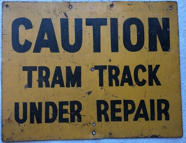
Sign, "Caution Tram Track Under Repair"
Prepared to advise pedestrians and motorists of tramway track work being undertaken in Ballarat.Demonstrates the methods the SEC used to advise of track works.Metal sign, steel, yellow background with black letters stating "Caution Tram Track Under Repair". Has four holes top and one centrally along the bottom edge. Shows on the rear that a stand was once fixed to the rear of the sign.tramways, secv, ballarat, signs, track work -
 Southern Sherbrooke Historical Society Inc.
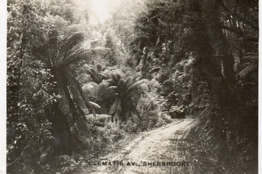
Postcard, Clematis Av, Sherbrooke
Sepia-toned postcard featuring Clematis Avenue Sherbrooke. Very heavily ferned on either side of road. Almost just a track. -
 Melbourne Tram Museum
Newspaper - Newspaper clipping, The Age Newspaper, "Trams CEO on a track to lift service", 01/07/2023
Interview with Yarra Trams CEO, Carla Purcell. Appointed to CEO role by Yarra Trams owner Kelli's Downer in November 2022, but started in April 2023 after returning from maternity leave. Tender process is underway for next tram franchise, currently worth $500M per year. Yarra Trams have operated the network for 13 years with current contract expiring at end of 2024. Tram patronage currently at 75% of pre-Covid levels. Melbourne's tram network currently consists of 475 trams, 250 km of track, 2300 employees servicing 200M annual passengers.Informative interview with Carla Purcell, CEO of Yarra TramsNewspaper clipping from the Age titled: "Trams CEO on a track to lift service"tramways, ceo, yarra trams, keolis downer-edi, tender documents, trams -
 Lakes Entrance Historical Society
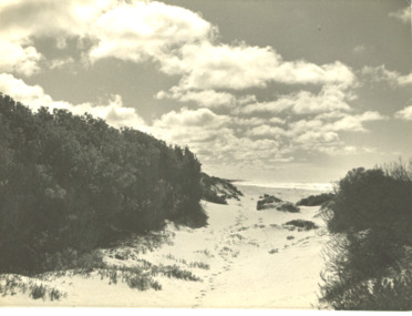
Photograph - sand hummocks Lakes Entrance Victoria
track through vegetation and sand hummocks with distant ocean view. Part of western end of township across Cunninghame Arm in distance Lakes Entrance VictoriaBlack and white photograph showing track through vegetation and sand hummocks with distant ocean view. Part of western end of township across Cunninghame Arm in distance Lakes Entrance Victoriatopography, beach, ocean -
 Ringwood and District Historical Society
Newspaper, Scrapbook Clipping, Library Collection, Ringwood, Victoria
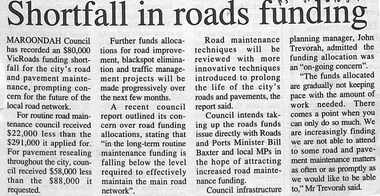
Newspaper clipping from "The Post", 16-8-95, P5 - Shortfall in roads fundingMaroondah Council has recorded an $80,000 Vicroads funding shortfall for the city's road and pavement maintenance, prompting concern for the future of the local road network. -
 Mt Dandenong & District Historical Society Inc.
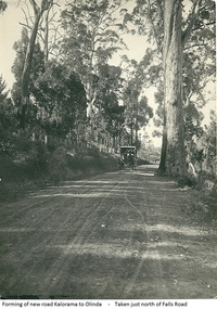
Photograph, Forming Of New Road Kalorama To Olinda, early 1920s
The new Main Road, now Mt Dandenong Tourist Road, was completed in 1926. This scene is looking towards Montrose down from the intesection of Falls Road.Scene of wagon drawn by two horses on wide dirt road with large trees on side of road. Taken just north of Falls Road.wagon, road, main road, mt dandenong tourist road, falls road, horse -
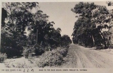
 Phillip Island and District Historical Society Inc.
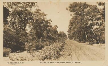
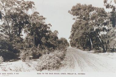
Photograph - Post Card, 1919
Donated by Stan McFee from the Keith McIlwraith Collection.Black & White Postcard of an unmade road to the Back Beach, Cowes. Road edged with trees and bushes."The Rose Series, P. 662" "Road to the Back Beach, Cowes, Phillip Is., Victoria". On Back: "This road 1 mile from Cowes" Letter: "Dear Marie, Wishing you many happy returns and the best of good wishes with much love. From all at "Heath Hill".road to back beach, cowes, phillip island, stan mcfee, keith mcilwraith collection -
 Melbourne Tram Museum
Slide, Keith Kings, 12/09/1959 12:00:00 AM
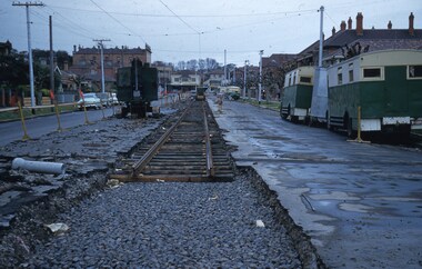
Colour slide, Kodak, fawn cardboard of track laying for the new South Melbourne / St Kilda Beach terminus in Park St, for the closing of the section of track into Mary St and Beaconsfield Parade. Has an early tracked excavator, parked on the road that has been broken up. Shows new track laid on timber sleepers with former wartime Austerity buses along side the road. Photo taken at the corner of Mary St 12/9/1959. Preliminary overhead work has been undertaken. Slide Number K(c)(292)Extensive handwriting on rear in ink and that it was photographed at 1/60 at f4.5.trams, tramways, st kilda, mary st, beaconsfield parade, south melbourne, new track, park st st kilda -
 Otway Districts Historical Society
Photograph, R. Preston, Beech Forest: Track gang in snow, c.1940, c.1940
The railway track was maintained initially by seven three-man gangs headed by a ganger. The gangers tended to be promoted into the Otways but many of their subordinate staff of repairers were local recruits. There were two track gangs at Beech Forest until 1954, so a large number of gangers and repairers was present over the years. World War 2 with petrol and rubber rationing provided a boost to the line. The 1939 bushfire killed a great deal of timber which had to transported out of the Otways, and the commencement of a vigorous wartime pulp wood traffic from Beech Forest meant that only the railway could efficiently handle the volume of traffic. By early 1940 not only the Garratt was running a daily train to Beech Forest but an NA goods train was scheduled to run at night. As a result the track gangs were also particularly busy at the same time.B/W. In snow at Beech Forest, a track gang on a trolley at the entrance to the Way and Works shed, comprising G. Newland, Ned Hewing, Bill Taylor, Jim Gowty, and Buck.beech forest; railways; g. newland; ned hewing; bill taylor; jim gowty; snow; track gang; -
 Phillip Island and District Historical Society Inc.
Photograph, Unknown
One of 16 photographs and postcards donated by Mary KarneyBlack & White postcard of a road to the Back Beach, Cowes."The Rose Series, P 662." "Road to the Back Beach, Cowes, Phillip Is., Victoria"dirt road, road to back beach cowes, phillip island, mary karney -
 Melbourne Tram Museum
Slide, Keith Caldwell, 12/03/1960 12:00:00 AM
Agfa Colour slide, cardboard mount, by Keith Caldwell dated 12 March 1960, of W5 809 turning from Market St into Flinders Lane. Tram has two sets of monograms and numbers on the sides, is fitted with trolley wheels and showing route 55. Has an advertisement for British Bedford's vehicles on the front. The strip for the advert racks on the sides of the trams has been installed. In front of the tram is a remnant of cable tram track in wood blocks. In the background is the Flinders St Viaduct and the Port of Melbourne Authority Building.in ink on top of the slide "W5 (Cable tracks), Market" and hand stamped "12 Mar '60"trams, tramways, market st, flinders lane, w5 class, cable trams, tram 809 -
 Kew Historical Society Inc
Photograph, Kilby Road, North Kew, 1916
Kilby Road, North Kew 1916. Annotation Reverse: "Kilby Road about 1916. Courtesy Mrs E. Bennett, Kew East."north kew, farming (kew), wade's farm (kew) -
Whitehorse Historical Society Inc.
Letter - Correspondence, Mullum Mullum Creek
Letter to the Minister of Land & Works from Richard R. Cross, George Hislop, Neil Faconer (sic) and Robert Leith .Letter to the Minister of Land & Works from Richard R. Cross, George Hislop, Neil Faconer (sic) and Robert Leith regarding a track through Crown Lands which has been applied for by Messrs. Logan and Galbraith. With map.Letter to the Minister of Land & Works from Richard R. Cross, George Hislop, Neil Faconer (sic) and Robert Leith .mullum mullum creek, roads and streets, cross, richard r., hislop, george, falconer, neil, leith, robert, warrandyte mitcham track, logan, galbraith -
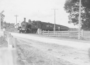 Ringwood and District Historical Society
Photograph, Railway crossing, Bedford Road, Ringwood - c1925 2 copies, 1925
Steam train at Bedford Road railway crossing, Ringwood. Ferntree Gully line.Written above photograph, "Bedford Road railway crossing - c1925". -
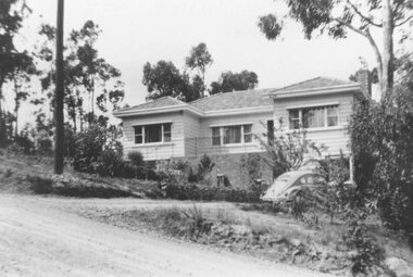 Ringwood and District Historical Society
Photograph, No 12 Glenvale Road, North Ringwood. 1964, 1964
House in Glenvale Road (2 views). See also #2936-2939 for views of Glenvale Road taken at the same time.Written on back of photographs, "1964 - 12 Glenvale Road. Original supplied by Garrett Gundry." (2 views) -
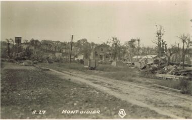 Bendigo Historical Society Inc.
Postcard - ACC LOCK COLLECTION: MONT DIDIER POSTCARD, 1914-1918
Postcard WW1 B&W image of ruined buildings of Mont Didier. Rail track and dirt road in foreground. Two copies A27postcard, ww1, mont didier, ruins, france -
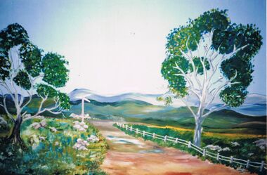 Bendigo Historical Society Inc.
Photograph - PETER ELLIS COLLECTION: GRAVEL HILL PRIMARY SCHOOL
Colour photograph. Painted scenery. Mountains. Gumtrees. Signpost. Dirt road. Gravel Hill Primary School. 1988 Production 'The Wallaby Track''education, primary, gravel hill school -
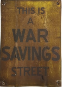 Kew Historical Society Inc
Sign, Commonwealth of Australia, This is a War Savings Street, 1939-1945
Elizabeth Nelson on eMelbourne has written that: "War Savings Streets were street-based savings groups that participated in the national war savings campaign during World War II. In May 1940 the Australian Government launched its Savings Certificates scheme which encouraged civilians to invest in the national war effort. Organisers of the savings campaign targeted Melbourne's suburbs individually with the aim of enlisting street savings groups. Each street group had a volunteer secretary who regularly sold war savings certificates to, and collected money from, other residents. The large number of war savings streets operating successfully in Melbourne made a significant contribution to the war effort."War Savings Street Street sign, presented to residents of Argyle Road, Kew (Vic) in 1942.Handwritten on reverse "Argyle Road Kew [Vic] 1942"second world war 1939-1945 - kew (vic), second world war 1939-1945 - fundraising, war savings street signs, ww2 -- savings certificates scheme -
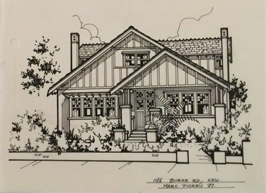 Kew Historical Society Inc
Drawing - Property Illustration, Margaret Picken, 1185 Burke Road, Kew, 1997
After training as a Cartographic Draftsman within the mining industry, I worked as a property illustrator for real estate firms in the eastern suburbs of Melbourne for 23 years from 1983. I initially photographed houses with a Polaroid camera and made a 'thumbnail' sketch while there. The photos were used to scale off a sketch in pencil and then that sketch was overlaid with drafting film and the 'pen and ink' completed. The pens I used were the Rotring ‘Rapidigraph’ drafting pens. The ink was also made by Rotring (German).The film was ‘Rapidraw’, polyester drafting film, double matte. It takes a very fine line and doesn’t bleed. As well as house sketches, there were often floor plans and site plans ordered. Aerial sketches were ordered when the property needed an overall view. (Margaret Picken, 2020)This drawing is one of a series created by Margaret Picken for a range of real estate agents in Melbourne between c.1983 and c.2005. Each work is signed and dated by the artist.Gift of Margaret Picken, 2020Pen and ink architectural drawing on drafting film of 1185 Burke Road, Kew by Margaret Picken.1185 BURKE ROAD., KEW / MARG PICKEN '97artist -- margaret picken 1950-, architectural drawings -- houses -- kew (vic.), 1185 burke road -- kew (vic.) -
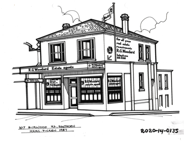 Hawthorn Historical Society
Drawing - Property Illustration, 107 Burwood Road, Hawthorn
'After training as a Cartographic Draftsman within the mining industry, I worked as a property illustrator for real estate firms in the eastern suburbs of Melbourne for 23 years from 1983. I initially photographed houses with a Polaroid camera and made a 'thumbnail' sketch while there. The photos were used to scale off a sketch in pencil and then that sketch was overlaid with drafting film and the 'pen and ink' completed. The pens I used were the Rotring ‘Rapidigraph’ drafting pens. The ink was also made by Rotring (German).The film was ‘Rapidraw’, polyester drafting film, double matte. It takes a very fine line and doesn’t bleed. As well as house sketches, there were often floor plans and site plans ordered. Aerial sketches were ordered when the property needed an overall view.' (Margaret Picken, 2020)This property illustration is one of a series created by Margaret Picken for a range of real estate agents in Melbourne between c. 1983 and c. 2006. Each work is signed and dated by the artist.Gift of Margaret Picken, 2020Pen and ink property illustration on drafting film of 107 Burwood Road, Hawthorn by Margaret Picken.107 Burwood Road, Hawthorn, Marg Picken '87. artist - margaret picken 1950- -
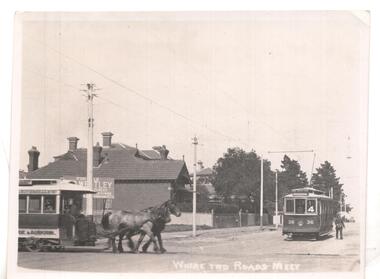 Ballarat Tramway Museum
Photograph - Black & White Photograph/s
Black & white photo ex Postcard? titled 'Where two roads meet', showing a horse tram ( Hawthorn Bridge to Auburn Road (Riversdale Road) and Prahran and Malvern No. 36 on Glenferrie Road with Deepdene destination, at the intersection of Riversdale & Glenferrie Roads, Hawthorn. Corner block (SE) behind photo has a 'For Sale' sign on it, with houses in background. Now a block of shops. Tram No. 36 is an F class car, later renumbered - see p14 of Destination City, 4th edition. See also inscriptions. Questions: How horse tram number determined and date of photograph??`` Reimaged 17/7/2017 both front and back.'T101, No. 26 horse tram of Hawthorn Tramway Trust in Riversdale Road. No. 36 toastrack (enclosed cross seat) of the Prahran & Malvern Trams in Glenferrie Road, Hawthorn 1917. Horse trams ran from Auburn Road to Hawthorn Bridge and connected with the Richmond cable trams. W.Jack.'trams, tramways, pmtt, horse trams, riversdale road, glenferrie rd , tram f 36 -
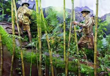 Australian Army Museum of Western Australia
Diorama, 2015
This diorama is the central feature in the World War 2 Gallery - South West Pacific area. Soldiers are shown still wearing khaki uniforms including shorts. Details include helmet, .303 SMLE rifles, small pack and fighting order. Japanese "Woodpecker" machine gun is show abandoned beside the track.1:1 scale diorama showing Australian patrol advancing up the Kokoda Track in light fighting order circa August 1942.kokoda -
Whitehorse Historical Society Inc.
Document, Motor Cycle Climb and mud bash|A Walk down memory lane|An early glimpse of Royton Street, 1994
Hartwell Motor Cycle Club.Hartwell Motor Cycle Club. The East Burwood section of its run comprised Holland road, Burwood Road and Ely Road. It was very steep and muddy. Description of a walk along Burwood Road to Middleborough Road in 1929 - 30. History of Royton Street, East Burwood and its neighbourhood from the 1930's to the present.Hartwell Motor Cycle Club. motor cycles, hartwell motor cycle club, holland road, burwood east, eley road, burwood east, burwood east state school no 454, royton street, burwood east, walford family, orchards, cooinda court, burwood east, market gardens, east burwood methodist church, french, joseph a, black, roy, rescheck family, french, harry w, crow, ernie, mclean, leckie, newbigin family, royton street, burwood east, no 30, hele family, french family, carrol family, tally ho post office, walford family -
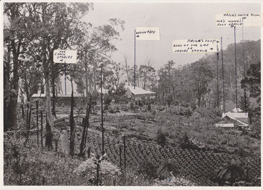 Mt Dandenong & District Historical Society Inc.
Photograph, 1908 View of the Kalorama Gap from Main Road With Labelling, 1908
Photograph with labels attached to front identifying buildings. View of the Kalorama Gap from main Road (now Ridge Road), looking across Walker's raspberry patch with Mountjoy coaching stables on the LHS and Mountjoy Guest House in centre. Price's house and shop on the RHS. This photograph has a detailed inscription on the back handwritten by John Lundy-Clarke in 1974.1908 View of the Kalorama Gap from main Road – now Ridge Road above Lot 2 of the Village Settlement. Looking across Walker’s raspberry patch with “Mountjoy” coaching stables on left. “Mountjoy” in centre. Prices house and shop on right with Hands “Beulah Tearooms” above Prices roof. On hillside beyond Hand’s is the slope now taken up by Kalorama Terrace. Walker’s well, then newly dug is in lower right hand corner below the tree fern head. Mt Kalorama is the hill top right. Track leaving Main Road left is Walker’s entrance drive.kalorama, kalorama gap, walker, beulah tea rooms, price, hand, mountjoy, mt kalorama -
Whitehorse Historical Society Inc.
Article, Ire over direction of Path Plan, 2016
The Blackburn Village Residents' Group wants a bike and pedestrian path along the north side of the railway line instead of the south side as proposed by council but the Whitehorse Council states this is not sensible.The Blackburn Village Residents' Group wants a bike and pedestrian path along the north side of the railway line instead of the south side as proposed by council but the Whitehorse Council states this is not sensible. Another option the Group would prefer is the lowering of the tracks and the station to create a plaza there.The Blackburn Village Residents' Group wants a bike and pedestrian path along the north side of the railway line instead of the south side as proposed by council but the Whitehorse Council states this is not sensible.city of whitehorse, blackburn railway crossing, blackburn village residents' group, morrison, david -
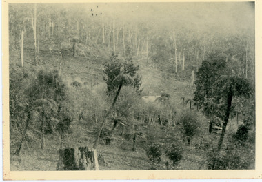 Mt Dandenong & District Historical Society Inc.
Photograph, Home of George Dodd at Olinda 1895, 1895
1895 picture of the home of George Dodd built c1880. Shows the Selector's Road made in the 1880s from Pig Lane in The Basin to the road in front of the Mt dandenong Hotel.The descriptive text on the reverse of this photograph was hand written by John Lundy-Clarke.1895 picture of the home of George Dodd built about 1880 showing the road the selectors made in the 1880s from Pig Lane to the main road in front of the present Mt Dandenong Hotel near the present end of the Basin-Olinda Road. It was never gazetted as a road as the Bruces objected to it and landslides in 1891 closed it temporarily and later landslides closed it permanently.george dodd, dodd, mt dandenong hotel, selector's road, road, pig lane -
 Phillip Island and District Historical Society Inc.
Photograph, Road to Back Beach, Cowes
Part of a collection of 'Rose & Valentine' series of Post Cards. Copied by John Jansson 1984Black & White Postcard. Road to the Back Beach, Phillip IslandThe Rose Series P662. Road to the Back Beach, Cowes, Phillip Island, Victorialocal history, photography, photographs, postcards, phillip island, black & white postcard copy., back beach -
 Kiewa Valley Historical Society
Photographs and copies of photographs of the pack horses and early horsemen who transported supplies to outposts in the Bogong High Plains, via cattle tracks before access roads were made
In the mid to late 1930’s survey outposts were established to plot the early stages of the Kiewa Hydro Electric System for the SECV in the Bogong High Plains. Before any roads were built, the old cattleman’s tracks were used with packhorses to deliver supplies, wages and mail and collect timesheets and correspondence from the workmen and dam builders living in canvas tents and at the outlying survey posts. The trip up the mountain was long and hard and dangerous for both horse and man Most of the men of the survey teams were not bush-men and were often ill equipped for the harsh weather and living conditions of bush camping, often arriving in their city clothes ready for work. The tent city at Bogong was destroyed by bush fires in 1939 after which an access road was built from Mt Beauty to transport building materials for more permanent dwellings for workmen. Pack horses continued to be used for transporting goods etc. to workers further up the mountain.Without the work of horsemen and their pack horses providing supplies and communications for outlying outposts, surveying and early planning for the Kiewa Valley Hydro Electric scheme could not have gone ahead and the dams and power stations which support the system could not have been constructed. The Hydro-electric scheme, and the workers who planned and built it play a major part in the early history of the Kiewa Valley and many original families still remain living, or have ties with the local area.: Set of 21 black and white photographs and copies of photographs depicting the pack horses and the men who handled them, transporting supplies and correspondence to the outlying camps and survey posts in the Bogong High Plains, via the rough cattlemen’s tracks. Photographs also show the early tent camps of the workers. Some photos mounted on A4 white paper. Some photos enlarged to A3 poster size for display1. Handwritten on back – Max Lawrence 2. -8 No inscriptions 9. Handwritten on back- Packing in supplies for early workers of the Kiewa Hydro scheme. There were no roads in the early days of the scheme 10. Printed on bottom of photo- Roper’s cattle on road below Howman’s Gap 11. Handwritten on back – Roper’s et al about to leave for the high plains 12. Printed under photo- Syd Ryder at the Pretty Valley Cut-Out (JBR) 13-16. No markings 17. Printed under photo- Gwen Talbot visits the Camp area. 1937 18. Handwritten on back- 14/1 Barbara Talbot 19. No markings 20-21. No markings 22. Printed under photo- STATE ELECTRICITY COMMISSION OF VICTORIA. Date: 15-3-45 Time: 8.0pm No: K 1838 Kiewa Hydro-Electric Works, Investigations 1944-1945 – Survey Camp at Young’s Hut pack horses; bogong high plains; survey posts; supplies delivery