Showing 864 items
matching water colour
-
 Brown Hill Progress Association Inc.
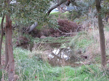
Photograph - Colour, Clare Gervasoni, Waterhole in the Yarrowee Creek near Brown Hill Hotel, 2016, 01/06/2016
brown hill, yarrowee creek, waterhole, water hole -
 Ballarat Heritage Services
Photograph - Photograph - Colour, Kathleen Gervasoni, Red Rock, Alvie, 1989, 02/09/1989
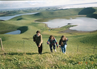
Red Rock, Alvie, near Colac, is a complex of approximately 30 volcanic eruption points and is the Southern most of a chain of three volcanoes, the others being Warrion Hill and Alvie Hill. It is arguably the youngest eruption point in Victoria at around 8000 years, especially since the age of Mt Napier has been progressively pushed back. The highest point (on the Northern side) has many interesting features, including some awesome spatter ramparts. Driving around the rim to the south, you can also see layered tuff. There are some good views out to Lake Corangamite and the lava flows (probably from Warrion Hill) can be seen where they have entered the lake. Most of Red Rock is in private land, with two lookout points with some interpretive information. The water depicted in this photograph is not evident in 2019. Type: Volcanic Complex Location: South of Alvie, Victoria Last Eruption: 8000 years ago Access: Mostly private land, but there is an access road and some interpretive signage Visited: Visited Colour photograph of sisters Clare Gervasoni (left), Ann Gervasoni (centre) and Lisa Gervasoni and Red Rock, Alvie clare gervasoni, lisa gervasoni, ann gervasoni, red rock alvie -
 Ballarat Heritage Services
Photograph, Old Hepburn Hotel, 2019, 06/02/2019
The Old Hepburn Hotel has been a watering hole in Heburn since the 1850s. The original building burnt down in a bushfire in 1906 but was rebuilt in 1912. The freehold on the building has been sold in early 2019, but it is not known what will happen to the venue. The hotel closed in midMarch 2019.Colour photograph of the Old Hepburn Hotel in Main Road, Hepburn, Victoria.old hepburn hotel, hepburn -
 Ballarat Heritage Services
Photograph - Colour, Volcanic Crater at Tower Hill, 2017, 2017
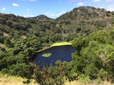
Tower Hill is a volcanic formation believed to have erupted about 32,000 years ago. Its formation is known as a "nested maar" and it is the largest example of its type in Victoria. During formation, molten lava pushed its way up through the Earth’s crust and encountered a layer of water-bearing rock. Violent explosions followed creating a shallow crater which later filled with water to form the lake. Further eruptions occurred in the centre of this crater, creating the islands and cone shaped hills. In 1892 Tower Hill became Victoria’s first National Park. In 1961, Tower Hill became a State Game Reserve under the then Fisheries and Wildlife Department and a major re-vegetation program began. (https://www.towerhill.org.au/index.php/about-reserve/history, accessed 23 December 2019)Colour photographs of a lake in a volcanic crater at Tower Hill, Victoria. volcano, crater, lake, tower hill -
 Lakes Entrance Regional Historical Society (operating as Lakes Entrance History Centre & Museum)
Photograph, 1999
... lime in his glass making business at Lakes Tyers. Water supply ...Site of lime burning operations from 1870's. Lime burnt for agricultural purposes. Cocky Roberts was using lime in his glass making business at Lakes Tyers.Colour photograph of the McCrae Lime Kiln site east side shows work site now encroached on by bushland. Toorloo Arm Victoriawater supply -
 Lakes Entrance Regional Historical Society (operating as Lakes Entrance History Centre & Museum)
Photograph, 1999
Built 1942 - 43 to ensure as adequate water supply for fire fighting purposes, after the devastation of the 1939 forest fires. Used by locals as a swimming pool until flooding in the 1980's filled the weir with silt.Colour photograph of Costicks Weir, Old Colquhoun Road, Colquhoun Forest. Shows manmade dam in bush setting. Constructed by building a weir wall across a small natural gorge. Nowa Nowa Victoriavegetation -
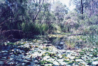 Lakes Entrance Regional Historical Society (operating as Lakes Entrance History Centre & Museum)
Photograph, 1999
Water lilies reputedly planted by Mrs Horsfield of Lakes Entrance Garden Club.Colour photograph of the lily pond near the railway trestle bridge at Stoney Creek, shows a pond covered with lily leaves and flower buds, surrounded by scrubby bushland. Nowa Nowa Victoriavegetation -
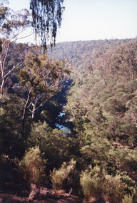 Lakes Entrance Regional Historical Society (operating as Lakes Entrance History Centre & Museum)
Photograph, 1999
Boggy Creek Gorge cuts through volcanics just before it meets salty water at Nowa Nowa Arm of Lake Tyers.Colour photograph from a vantage point of the distant Boggy Creek Gorge surrounded by steep tree and scrub covered ranges. Nowa Nowa Victoriavegetation -
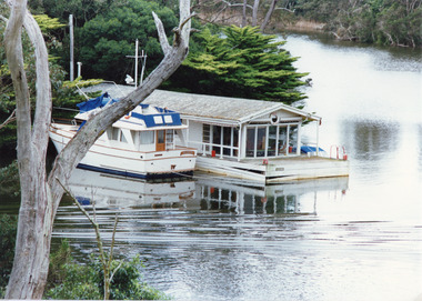 Lakes Entrance Regional Historical Society (operating as Lakes Entrance History Centre & Museum)
Photograph, Tambo Shire, 1994
Also second identical copyColour photograph of a holiday house, built over the water at Box's Creek, a motor cruiser moored beside the house. Metung Victoriawaterways, transport -
 Lakes Entrance Regional Historical Society (operating as Lakes Entrance History Centre & Museum)
Photograph, Tambo Shire, 1990c
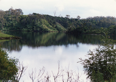
Second copy image identical 20.5 x 28.5Colour photograph of a bay in the North Arm. It shows the calm waters of the lake surrounded by steep wooded banks, a grassy point with remains of fence or jetty. Reflections of surrounding vegetation in water. Lakes Entrance Victoriajetties, retail trade, waterways, topography -
 Lakes Entrance Regional Historical Society (operating as Lakes Entrance History Centre & Museum)
Photograph, Holding M, 2000
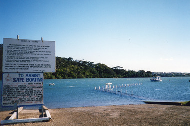
Date made January 2000Colour photograph of high tide in the North Arm. It shows the boat ramp and jetty under water, boat moored in lake, pelican fishing nearby. Warning and instruction signs on shore. Kalimna Heights in background. Lakes Entrance Victoriaboats and boating, vegetation, waterways, topography -
 Lakes Entrance Regional Historical Society (operating as Lakes Entrance History Centre & Museum)
Photograph, 1980
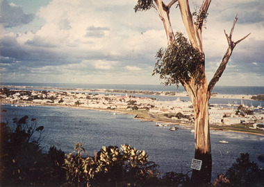
Also two different views of Lakes Entrance from KalimnaColour photograph showing the township situated on the land between the two stretches of water,the North Arm and the Cunninghame. In the background can be seen the sand hummocks and the Southern Ocean. Lakes Entrance Victoriaconstruction, township, waterways, bridges -
 Lakes Entrance Regional Historical Society (operating as Lakes Entrance History Centre & Museum)
Photograph, Nelson Joan, 1980c
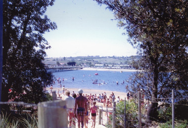
Colour photograph of a crowd on the beach at the southern shore of Cunninghame Arm. It shows many people enjoying the sand and water, footbridge and northern shore of township in distance. Lakes Entrance Victoriawaterfront, parks, restaurant -
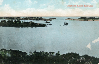 Lakes Entrance Regional Historical Society (operating as Lakes Entrance History Centre & Museum)
Photograph, 1910c
Colour tinted photograph of the entrance from Bass Strait to the Gippsland Lakes. It shows the small village on the hummocks, Bullock Island with bathing boxes at western end, machinery building groyne's from Bullock Island. Boat in the water. Lakes Entrance VictoriaGippsland Lakes Entranceislands, ships and shipping, topography, waterways -
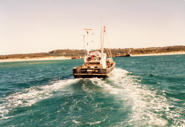 Lakes Entrance Regional Historical Society (operating as Lakes Entrance History Centre & Museum)
Photograph, Hammarstrom Ian, 1987 c
Colour photograph of the fishing boat Southern Hope approaching the entrance channel, from the ocean, shows sandy beach each side of entrance piers and shallow water over the outer bar, sea calm. Lakes Entrance Victoriaships and shipping, waterways, fishing industry -
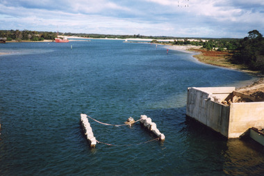
 Lakes Entrance Regional Historical Society (operating as Lakes Entrance History Centre & Museum)
Photograph, 2000
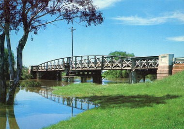
Date made 2 October 2000Colour photograph of the pontoon testing for foundations for proposed new bridge over North Arm water, old bridge Kalimna side. Lakes Entrance Victoriabridges, roads and streets, machinery -
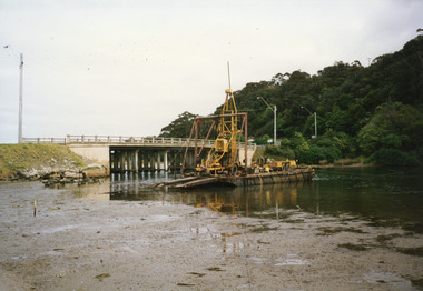
 Lakes Entrance Regional Historical Society (operating as Lakes Entrance History Centre & Museum)
Photograph, 2000
Date made May 2000.Colour photograph of diving operations to attach crane cable to underwater section of piers of old North Arm bridge. Diver in water, small tinny standing by with two men aboard. Lakes Entrance Victoria.bridges, waterways, machinery, public works -
 Lakes Entrance Regional Historical Society (operating as Lakes Entrance History Centre & Museum)
Photograph, Murray Views Gympie, 1980
Photo printed on Jumbo card by Murray Views, Gympie QLDColour photograph showing swing bridge on Latrobe River, shows north facing side of bridge, willows on opposite bank on site of Latrobe River wharf, river running very high, two red gum trees in water on left. Longford Victoriabridges, advertising -
 Lakes Entrance Regional Historical Society (operating as Lakes Entrance History Centre & Museum)
Photograph, 1999
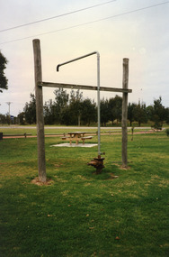
In late 1958 bore put down in an attempt to obtain good quality water for a reticulated town water supply. Water unsuitable, but during drought years when water supply from Nicholson River was restricted, water from this bore available for public use. Bore plugged, structure removed December 2000. Site marked with plaque March 2001, by Lakes Entrance Historical Society.Colour photograph of the head works including feed pipe of water bore sunk in late 1958 on the Public Reserve bound by Marine Parade and the highway approach to North Arm Bridge, Lakes Entrance, Victoria.sports -
 Lakes Entrance Regional Historical Society (operating as Lakes Entrance History Centre & Museum)
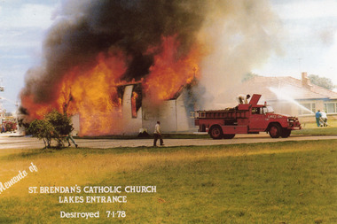
Photograph, 1978
Date made 7 January 1978Colour photograph of the disastrous fire which destroyed St Brendans RC Church. Two fire trucks in view, three people directing water onto home of Nuns next door to church. Ferris wheel of carnival in distance behind church. Lakes Entrance VictoriaMemento of St Brendan's Catholic Church, Lakes Entrance, destroyed 7.1.78schools, religion, buildings, room display -
 Lakes Entrance Regional Historical Society (operating as Lakes Entrance History Centre & Museum)
Photograph, 2000
School built by local community as school and public hall in 1900, 26 July, classified by National Trust.Colour photograph of the old Noorinbee State School no. 3372, East Gippsland, shows a view of the timber building with rebuilt corrugated iron chimney, corrugated iron roof, water tank at rear. Noorinbee Victoriaschools -
 Lakes Entrance Regional Historical Society (operating as Lakes Entrance History Centre & Museum)
Photograph, 2004 c
... Colour photograph showing flood water in Bulmer Street... Entrance gippsland Also second colour photograph taken at same time ...Also second colour photograph taken at same time 04666.1 10 x 15 cmColour photograph showing flood water in Bulmer Street looking south towards the Cunninghame Arm Lakes Entrance Victoriafloods, naturalm disasters, township -
Lakes Entrance Regional Historical Society (operating as Lakes Entrance History Centre & Museum)
Photograph, 1970
This provided good pressure for the house and septic tankColour photograph of cottage at 133 Myer Street showing stainless steele milk vat on high tank stand to collect water from town water supply Lakes Entrance Victoriabusinesses, roads and streets -
Lakes Entrance Regional Historical Society (operating as Lakes Entrance History Centre & Museum)
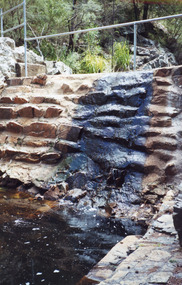
Photograph, Judy Davies, 1990 c
... Colour photograph of water spilling over the rock wall... Colour photograph of water spilling over the rock wall ...Also a colour photograph of waterway adjacent to Cossticks Weir East Gip[psland 04650.1 15 x 10 cmColour photograph of water spilling over the rock wall at Cossticks Weir East Gippsland Victoriabridges, waterways -
 Lakes Entrance Regional Historical Society (operating as Lakes Entrance History Centre & Museum)
Postcard, Engelander, John & Co Pty Ltd, 1950c
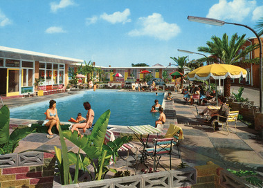
Colour postcard of the outdoor swimming pool at Glenara Motel, Lakes Entrance, Victoria. Shows adults and children on the paved area around the pool and three people in the water.motels, recreation, entertainment, rsl clubs -
 Lakes Entrance Regional Historical Society (operating as Lakes Entrance History Centre & Museum)
Postcard
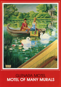
Colour postcard of one of the eighteen murals decorating the internal walls of the Glenara Motel, Lakes Entrance, Victoria. This one reflects the painter's romanticism showing a young couple in a small boat on a lake with water lilies and swans.Glenara Motel Motel of Many Murals (on front)motels, arts, rsl clubs -
 Lakes Entrance Regional Historical Society (operating as Lakes Entrance History Centre & Museum)
Photograph, 2000
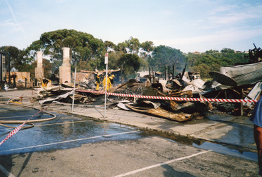
Date made December 2000Colour photograph showing destroyed Club Hotel. Photo taken from the Esplanade, front carparks covered with water and hoses as Lakes Entrance Fire Brigade damp down remaining trouble spots. Lakes Entrance Victoriahotels, fire brigade, disasters -
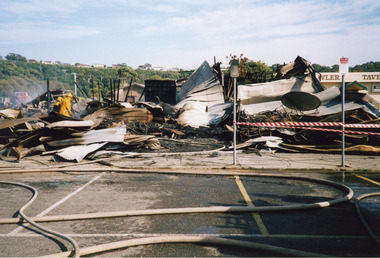 Lakes Entrance Regional Historical Society (operating as Lakes Entrance History Centre & Museum)
Photograph, 2000
Date made December 2000Colour photograph showing smouldering remains of the Club Hotel. Fire brigade truck in background and members dampening down debris. Carpark covered in hoses and water. Lakes Entrance Victoriahotels, fire brigade, disasters -
Lakes Entrance Regional Historical Society (operating as Lakes Entrance History Centre & Museum)
Photograph, Kate Aver, 1/06/1998 12:00:00 AM
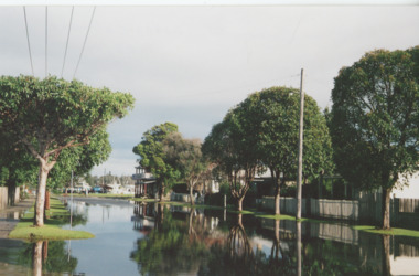
Colour photograph taken during floods showing George Kyriakoo and Michael Pompaii with water tariff sign at Sherwood Lodge Motel Lakes Entrance Victoriafloods, caravan parks -
Lakes Entrance Regional Historical Society (operating as Lakes Entrance History Centre & Museum)
Photograph, Jack Donelly, 1998 c
Photograph taken from Jemmys PointColour photograph showing discoloured flood water backed up by the incoming tide with fishing boat Crianda shown approaching the Western Pier at the entrance Lakes Entrance Victoriafloods, accommodation