Showing 7808 items matching "main street"
-
 Whitehorse Historical Society Inc.
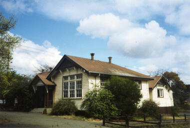
Photograph, Vermont Primary School No 3133, 1980's
The first of the Vermont Primary School buildings was erected on 1872. In 1907 a room was built onto the west side of the building and a new classroom and cloakroom were erected in 1922. Due to rising numbers and traffic volume, Vermont Progress Association urged the government to relocate the school buildings to a less prominent site, and new school buildings were erected in Nurlendi Street in the 1950's. The original timber building remained on the site until its removal to the Nurlendi Street site in the 1990's, and is on the city of Whitehorse Heritage Review.Coloured photograph of the Vermont Primary School while it was standing vacant from the 1950's until 1989 when it was moved to the main school in Nurlendi Road, Vermont. The school was on the North West corner of Canterbury and Mitcham roads facing Mitcham Road. Canterbury Road can be seen through the trees at the left of the photograph.vermont primary school no 3133, primary schools -
 City of Ballarat Libraries
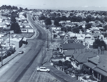
Photograph, View south west along Barkly Street from Ballarat Fire Station Tower, Ballarat East
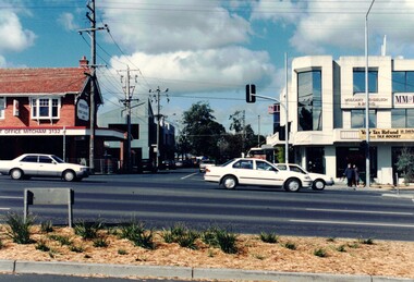
... street east ballarat main road len t frazer reserve View south ...An image from the Herbert Richmond collection, gifted in 1982 to the Ballarat Library. The collection contains approximately 200 photographs of Ballarat and district in the 1940s, 50s and 60s, as well as photo albums, glass negatives and other memorabilia. Herb Richmond was a keen photographer, a foundation member and a life member of the Ballarat Camera Club, and a photographer with the Ballarat Courier during the 1940s. The Ballarat Camera Club named an annual award after him. Mr Richmond died in 1981 aged 79. These images were digitally re-photographed by members of the Ballarat Camera Club in September 2006.barkly street, east ballarat, main road, len t frazer reserve -
 City of Ballarat Libraries
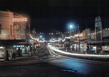
35mm Slide, Bridge Street Ballarat circa late 1950s
A night exposure of Bridge Street looking west. The tram tracks are clear, one set going straight ahead up Victoria St hill, the other set turning along Main Road. Stone's at Stones Corner was a select ladies dress shop for many years. Mrs Bon Strange and her husband Bert were well known Ballarat residents. When Mrs Strange died some years ago, her extensive slide collection was sorted through and those relevant to Ballarat were gifted to the Ballarat Library. bridge street -
 City of Ballarat Libraries
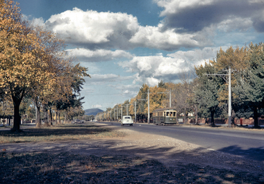
35mm Slide, Sturt Street West, Ballarat circa late 1950s
A lovely shot of the western end of Sturt Street, looking east to Mt Warrenheip. Not much traffic today! Just a tram and an early Holden, yet at the time of this photograph, this was the main highway through to Adelaide. Mrs Bon Strange and her husband Bert were well known Ballarat residents. When Mrs Strange died some years ago, her extensive slide collection was sorted through and those relevant to Ballarat were gifted to the Ballarat Library.sturt street, trams -
 City of Ballarat Libraries
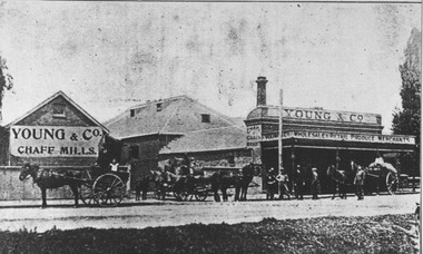
Photograph, Young & Co Chaff Mills, Ballarat circa 1906
Young & Co Chaff Mills was located in Main Road, Ballarat East.young & co, mills, ballarat east, commerical, main road -
 City of Ballarat Libraries
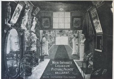
Photograph, Main entrance Coliseum Picture Palace circa 1915
The Coliseum Picture Palace was located in the Grenville - Little Bridge Street area. building, public, coliseum picture palace, entertainment, cinema, ballarat, interior -
 City of Ballarat Libraries
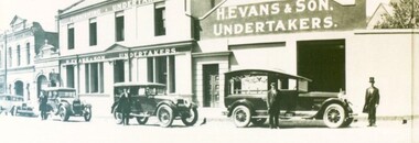
Photograph - Card Box Photographs, H. Evans & Sons Undertakers, Ballarat circa 1931
Henry Evans can be seen wearing the top hat. The building on Main Road was originally the London Chartered Bank built in circa 1875. The original facade is believed to be behind new brickwork.henry evans, undertakers, main road, london chartered bank, ballarat, vehicles, funeral, building, h. evans & son -
 City of Ballarat Libraries
Photograph - Card Box Photographs, J. Allen & Son, Ballarat circa 1880
James & Robert Allen at their drapery and millinery shop. The premises were on Main Road. j. allen & son, james allen, robert allen, building, manufacturing, commerical, drapery, millinery, main road, ballarat east -
 City of Ballarat Libraries
Photograph - Card Box Photographs, Interior of the Ballarat Town & City Mission Hall circa 1930
The hall was located on Main Road.ballarat town & city mission, building, public -
 City of Ballarat Libraries
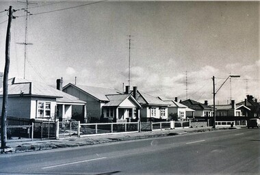
Photograph - Card Box Photographs, Houses on the west side of Main Road, Ballarat 1969
... City of Ballarat Libraries Eureka Centre Eureka Street ...main road, private dwellings, buildings -
 Whitehorse Historical Society Inc.
Photograph, Station Street Mitcham
... Coloured photograph of Station Street Mitcham looking South... photograph of Station Street Mitcham looking South. Main road ...Coloured photograph of Station Street Mitcham looking South. Main road is Whitehorse Roadstation street mitcham, streets -
 Ballarat Heritage Services
Postcard, Ballarat Botanical Gardens, c1908
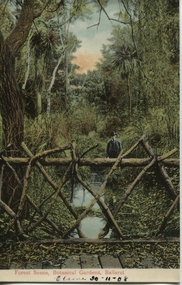
"Within six years of its first land sales in 1852, founder members had challenged council over horticultural decisions and Ballarat's main thoroughfare contained fences squares, trees and flower beds. The major works that projected the Garden City image were the street plantings, parks and botanical gardens ..." Reference: Michael Taffe, Growing a garden City: Ballarat Horticultural Society 1859-2009, BHS Publishing, 2014, p. 10.This postcard shows how the botanical gardens in Ballarat, famous for being a Garden City.Coloured postcard Forest Scene, Botanical Gardens, Ballarat printed in red at bottom of card. Elaine 30-11-08 handwritten in black ink underneath.botanical gardens, ballarat, forest scene, gardens, botanical, -
 Hume City Civic Collection
Book, Led by the Spirit
This book was commissioned by the Parish of Our Lady of Mt. Carmel, Sunbury for a school reunion held in 2011. The main researcher on this book was Tracie Oldham.A green book with white writing and sketch of a church on front cover.Led by the Spiritchurches, our lady of mt carmel church, sunbury, local history, school reunion -
 Hume City Civic Collection
Drawing, S.Calvert, STAFF OFFICERS OF THE VICTORIAN VOLUNTEER FORCE
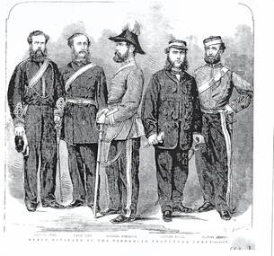
The five men who were staff officers of the Victorian Volunteer Force were Captain Snee, Major Pitt, Colonel Anderson, Captain Payne and Captain Burton. The Victorian Volunteer Force was the main defence force in Victoria after the withdrawal the Imperial Troops in 1870. IN that same year a Permanent Artillery Corps ( Victorian Artillery) was also formed. The Volunteer force was disbanded in 1884 and replaced by the Victorian Militia force. The members were paid and enrolled for a set term.A black and white photograph of an etching of 5 officers in the Victorian Volunteers Force.victorian volunteer force., victorian artillery, victoria militia, military history -
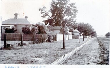 Hume City Civic Collection
Photograph - Evans Street, Sunbury, c1880 - 1900s
The photograph shows a picture of Evans Street Sunbury taken from the T intersection at Macedon Street and looking south. When the photograph was taken it was one of Sunbury's main residential areas. Since the 1980s the houses in the image have been demolished and replaced with commercial development.- Over the years Evans Street has undergone much change from being a residential strip to being the main commercial hub in Sunbury.– An enlarged photograph of a streetscape with a row of trees growing along the footpath and a number of weatherboard Victorian style double fronted cottages. Both the roadway and footpath are not surfaced and the gutter is lined with stone pavers.sunbury -
 Hume City Civic Collection
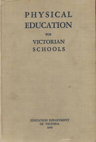
Book, Education Department of Victoria, Physical Education for Victorian Schools, 1946
A physical education course of study for primary and secondary school teachersA 480 paged bound text book with a grey cloth cover and navy blue printing on the cover and spine.non-fictionA physical education course of study for primary and secondary school teachers physical education, reference books, schools, teachers -
Hume City Civic Collection
Newspaper - The Sun News Pictorial, 8th May 1945
A copy of the Sun News Pictorial issued across Victoria on 8th May 1945 containing local and overseas news.An A3 size newspaper comprising 14 pages covering news of local and overseas interest as well as advertisements.non-fictionA copy of the Sun News Pictorial issued across Victoria on 8th May 1945 containing local and overseas news.newspapers, world war 2, germany's unconditional surrender -
 RMIT Design Archives
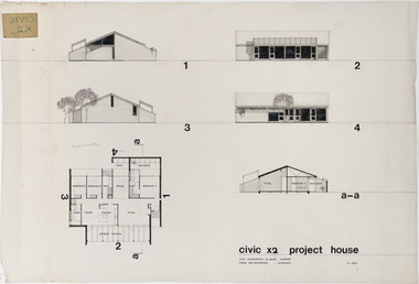
Architectural drawings, Civic x2 Project House
Robin Cocks (1941- ) and Peter Carmichael (1942 - ) formed their partnership in 1967, and designed some of Australia's most innovative project houses in the late 1960s and early 1970s. The award winning Civic Growth House (1974) was designed for Civic Construction. It provided clients with a modular grid and a range of components that allowed choice in location and spatial variation. The houses were designed to be expanded as families grew or as finance became available. The one-level Civic X2 was constructed in full-brick, included a pergola and deck, and a private courtyard off the main bedroom, This drawing includes floor plan, elevation and section.architecture, domestic architecture, project homes -
 Ballarat and District Irish Association
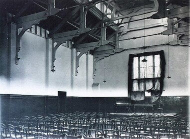
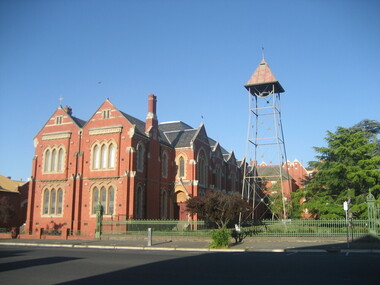
Photograph - Colour, Clare Gervasoni, St Patrick's Cathedral Hall, Ballarat, 2007, 20/11/2007
St Patrick's Cathedral Hall was erected in 1900 to the architectural plans of Clegg, Kell and Miller. The builder was Peter Bodger. The Cathedral Hall is a massive structure in the Gothic manner, with slender proportions and Gothic window detailing. The main hipped roof of the hall is intersected on both sides by four gables, and the front ridge is intersected by two further gables to form the street elevation. Internally the hall resembles many town halls except for the two tiers of Gothic windows and the manner in which the ceiling curves downward towards the walls. Pointed Gothic windows on the upper level intersect the curved ceiling in a simple groined junction. The plaster ceiling is coffered by intersecting beams, while a central skylight floods the hall with natural light. Other features of note are the ridging on the front gables, and the iron bell tower framed in steel angles and braced with criss-crossed rods, complete with a huge wheel and a great bell. St Patrick's Hall demonstrates a notable application of decorative schemes, particularly its highly decorated ceiling which has few parallels amongst other church halls in Victoria. The hall is in an important location as part of St Patrick's complex, as well as part of the group of churches which include St Andrew's Kirk and the former Baptist Church, opposite in Dawson Street. (http://stpatscathedral.weebly.com/cathedral-hall--presbytery.html, accessed 13 November 2013.A series of colour digital photographs showing a large red brick hall associated with St Patrick's Cathedral, Ballarat. The bell tower is situated to the right of the hall.ballarat irish, st patrick's cathedral hall, cathedral hall ballarat, bell, bell tower -
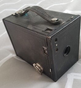 Numurkah & District Historical Society
Box Camera, Eastman Kodak Co
Black leather-leather look (Vinyl) rectangular box. Main lens and 2 viewfinder lenses on the front. Black leather handle, one view finder and metal opening latch on the top. One view finder and a winder key on the right hand side. Red film counter viewing window on the back, with markings (see below)No.2 Brownie / Use film No. 120 / Made in US by Eastman Kodak Co. Rochester NY -
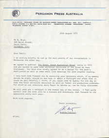 Robin Boyd Foundation
Letter, Andrew Fabinyi (Pergamon Press) to Robin Boyd, 25.08.1971
Letter summarising main points of recent conversation with Robin Boyd - agreement to publish Robin Boyd's manuscript for "The Great, Great, Australian Dream" early in 1972 with some minor revisions, to be received in a fortnight. Attachment included (see item D336.2)Typewritten, quarto, 1 page. -
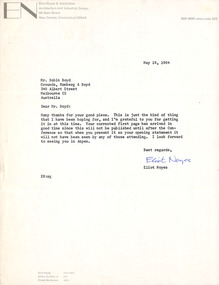 Robin Boyd Foundation
Letter, Eliot Noyes, Eliot Noyes to Robin Boyd, 19.05.1964
This second letter to Robin Boyd from Eliot Noyes, an American architect and industrial designer, is the second of two held by The Robin Boyd Foundation (see also D418). It thanks him for his good piece and also for his corrected first page.On letterhead Eliot Noyes & Architects, Architecture and Industrial design, 95 Main St, New Canaan, Connecticut. -
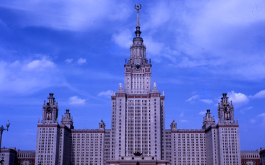 Robin Boyd Foundation
Slide, Robin Boyd, 1964
Colour slide in a mount. Main building of Moscow State University, Moscow, RussiaMade in Australia / 16 / AUG 64M / 10 (Handwritten)russia, slide -
 Ambulance Victoria Museum
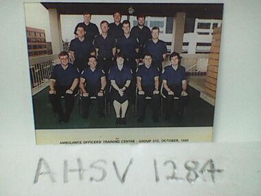
Photograph, Ambulance Officers Training Centre Group 37C, October 1990, 1990
Front Row L to R: Lee Klein, Mark Wallace, Georgina Rolington, Kevin Manson, Gary Carlson. Middle Row L to R: Geoff Goodman, Chris Caldecoat, Ray Main, Michael Ingamells. Back Row L to R: Bill Hogan, Michael Keating, Brendan Procter.Colour photograph of ambulance officer traineesambulance officers training centre -
 Old Colonists' Association of Ballarat Inc.
Photograph - Photograph - Colour, Ballarat Old Colonists' Association Homes, Charles Anderson Grove, Ballarat
HISTORY OF THE BALLARAT OLD COLONISTS' ASSOCIATION HOMES AT CHARLES ANDERSON GROVE, LAKE GARDENS One of the original objectives of the Association was “to provide the shelter of a house for those Pioneers of the Goldfields whom the reverses of fortune have deprived of the means of procuring the comforts of life in their declining years.” While the first home at Charles Anderson Grove was built in 1925 the Association had previously provided relief for needy pioneers from the time it was formed in 1883. Relief included monthly monetary payments, loads of firewood, medical assistance and distribution of Christmas boxes of groceries to deserving pensioners and in some cases payment of burial costs. Records indicate that in September 1922 three of the pensioners being assisted by the Association were accepted as residents in the newly erected Hassell Homes in Gillies Street (now demolished-opposite the High School). The first site for an Asylum for Indigent Members of the Old Colonists' Association was temporarily reserved from sale in October 1891. The site was approximately 28 acres in area in Mt Clear nearly opposite Midvale Shopping Centre in Main Road. The site was heavily timbered and when cleared over 260 tons of wood was sold to the Woah Hawp Gold Mining Company. A set of gates were erected but no homes built, although a plan for this reserve was drawn which showed twenty buildings ranging from one to four unit per building. The reserve was revoked in November 1909. The second site temporarily reserved in November 1909 as an Asylum was in Alfredton and consisted of some 7 acres and was adjacent to land reserved for an Abattoirs for the Ballarat Council. The reserve was revoked in February 1912 as it was deemed more appropriate to be added to the Abattoir site. Council suggested four (4) other sites in exchange for this land and they were inspected by the President, Vice President and Secretary on 22 December 1912. The first site inspected was land on the west side of Creswick Road opposite the brick kilns (now occupied by the showgrounds and oval). The land was described as being good quality, well fenced, no trees, good drainage and ample acreage but some distance from trams. The second site was Perry Park which was described as being good land, well fenced, having frontage to Gillies Street, good drainage and about 26 acres (but subsequently reduced to 10 acres). It was closely planted with Pinus Insignias and Wattle and had easy access from the Botanic Gardens tram. The third site was the North West portion of Victoria Park (corner of Sturt and Gillies Street) and was described as good land, well fenced and drained and well located. The fourth site was the South West corner of Victoria Park and known as Pound Paddock (corner of Winter Street and Gillies Street). It was considered to be low lying and too close to the Abattoir, and was also a considerable distance from trams. While the third site was recommended as the most suitable for the erection of homes it was considered unwise from the point of view as citizens to reduce the acreage of the park and therefore it was recommended that the Perry Park site be asked for as the most acceptable to the Association for the building of homes. The site was eventually temporarily reserved for an Asylum for Indigent Members of the Association in April 1914 with the gates from Mt Clear having been removed to the site a year earlier and eventually erected in 1917 for £12.10.0. In the same year the first 290 pine trees were advertised for removal in July and sold for £16. A sign indicating that the site was reserved for the erection of cottages was erected in September 1917. Stripping of the wattle bark (for tanning) and the cutting of the wood occurred in November 1918 with the land then being leased until it was required for the construction of the first homes in 1924. While the site was the third to be reserved it was the only one which was used for its intended purpose. It was named as Charles Anderson Grove in honour of Charles Anderson who joined the Association in 1918 and was President of the Association from 1942 to 1944. A number of cottages in the Ballarat Old Colonists' Association Retirement Village of Gillies Street, Ballarat.charles anderson grove, old colonists' club, ballarat, old colonists' association, old colonists' homes, retirement village -
 Old Colonists' Association of Ballarat Inc.
Photograph - Image, The History of Charles Anderson and Charles Anderson Grove, Ballarat
Information relating to Charles Anderson and Charles Anderson Grove, Lake Gardens, Ballarat. The Old Colonists' Association Ballarat Inc. is a not for profit charitable organisation providing accommodation for elderly people. It manages a 27 Home retirement village at Charles Anderson Grove, Ballarat. Accommodation is offered at significantly below market rates. It has been providing low cost accommodation to the elderly since the 1920s. The Association Council overseas the running of this facility on a voluntary basis. HISTORY OF THE BALLARAT OLD COLONISTS' ASSOCIATION HOMES AT CHARLES ANDERSON GROVE, LAKE GARDENS One of the original objectives of the Association was “to provide the shelter of a house for those Pioneers of the Goldfields whom the reverses of fortune have deprived of the means of procuring the comforts of life in their declining years.” While the first home at Charles Anderson Grove was built in 1925 the Association had previously provided relief for needy pioneers from the time it was formed in 1883. Relief included monthly monetary payments, loads of firewood, medical assistance and distribution of Christmas boxes of groceries to deserving pensioners and in some cases payment of burial costs. Records indicate that in September 1922 three of the pensioners being assisted by the Association were accepted as residents in the newly erected Hassell Homes in Gillies Street (now demolished-opposite the High School). The first site for an Asylum for Indigent Members of the Old Colonists' Association was temporarily reserved from sale in October 1891. The site was approximately 28 acres in area in Mt Clear nearly opposite Midvale Shopping Centre in Main Road. The site was heavily timbered and when cleared over 260 tons of wood was sold to the Woah Hawp Gold Mining Company. A set of gates were erected but no homes built, although a plan for this reserve was drawn which showed twenty buildings ranging from one to four unit per building. The reserve was revoked in November 1909. The second site temporarily reserved in November 1909 as an Asylum was in Alfredton and consisted of some 7 acres and was adjacent to land reserved for an Abattoirs for the Ballarat Council. The reserve was revoked in February 1912 as it was deemed more appropriate to be added to the Abattoir site. Council suggested four (4) other sites in exchange for this land and they were inspected by the President, Vice President and Secretary on 22 December 1912. The first site inspected was land on the west side of Creswick Road opposite the brick kilns (now occupied by the showgrounds and oval). The land was described as being good quality, well fenced, no trees, good drainage and ample acreage but some distance from trams. The second site was Perry Park which was described as being good land, well fenced, having frontage to Gillies Street, good drainage and about 26 acres (but subsequently reduced to 10 acres). It was closely planted with Pinus Insignias and Wattle and had easy access from the Botanic Gardens tram. The third site was the North West portion of Victoria Park (corner of Sturt and Gillies Street) and was described as good land, well fenced and drained and well located. The fourth site was the South West corner of Victoria Park and known as Pound Paddock (corner of Winter Street and Gillies Street). It was considered to be low lying and too close to the Abattoir, and was also a considerable distance from trams. While the third site was recommended as the most suitable for the erection of homes it was considered unwise from the point of view as citizens to reduce the acreage of the park and therefore it was recommended that the Perry Park site be asked for as the most acceptable to the Association for the building of homes. The site was eventually temporarily reserved for an Asylum for Indigent Members of the Association in April 1914 with the gates from Mt Clear having been removed to the site a year earlier and eventually erected in 1917 for £12.10.0. In the same year the first 290 pine trees were advertised for removal in July and sold for £16. A sign indicating that the site was reserved for the erection of cottages was erected in September 1917. Stripping of the wattle bark (for tanning) and the cutting of the wood occurred in November 1918 with the land then being leased until it was required for the construction of the first homes in 1924. While the site was the third to be reserved it was the only one which was used for its intended purpose. It was named as Charles Anderson Grove in honour of Charles Anderson who joined the Association in 1918 and was President of the Association from 1942 to 1944. CHARLES HENRY GRATTAN ANDERSON C.H.G. Anderson (Electoral Returning Officer) was elected to membership of the Old Colonists' Association, Ballarat, in October 1918. He was elected to the Association Committee in 1926, and appointed Treasurer of the Association on the resignation of F. Ellis until the end of the financial year in 1933. In 1936 Charles Anderson indicated he would not be available for the President's Chair and that he would retire from the Committee owing to pressure of work. C.H.G. Anderson was welcomed as a new member of the Association in 1938, and served as President of the Old Colonists' Association from 1942-1944. Midway through 1949 Charles Anderson was appointed Members Secretary and Manager of the Ballarat Old Colonists' Club at £5.0.0 per week and 10/- for entertainment, to commence work prior to 01 August 1949. He was to do 30 hours per week and be present on Friday and generally on Saturday nights. In 1957 a minute of sympathy was extended to Club Manager Charles Anderson on the loss of his son. In 1958 a bonus of £20.0.0 was paid to Charles Anderson in recognition of his service in assisting the Secretary/Manager taking over under difficult conditions. In March 1964 the Shire of Ballarat would not permit a private road to be named Anderson Grove as Anderson Street already existed in Ballarat but Charles Anderson Grove was deemed acceptable. A recommendation of the Committee was put to the AGM in 1967 that Charles Anderson be made a Life Member. In 1969 an Association meeting observed a minutes silence in memory of Chas Anderson. Charles Anderson was also a Committee member of Ballarat Mechanics' Institute from February 1940 to February 1970. He was President in 1948. Black and white photographic portrait of Charles Anderson.charles anderson, charles anderson grove, ballarat old colonists' club, old colonists' association, ballarat, ballarat mechanics' institute, hassell homes, woah hawp gold mining company, firewood, retirement village -
 Old Colonists' Association of Ballarat Inc.
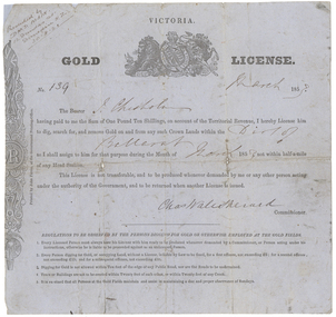
Document - Gold License, Gold License issued to John Chisholm
This miner's right was glued onto a page in a large album of photographic images of early Ballarat. Recognising their significance the Council of the Old Colonists’ Association of Ballarat Inc. had them removed and restored. The originals are now framed and on display in the Old Colonists’ Hall.Victorian Gold License made out to John Chisholm.Ballarat Victoria Gold License No. 139 March 1853 The Bearer J. Chisholm having paid to me the Sum of One Pound Ten Shillings, on account of the territorial revenue, I hereby License him to dig, search for, and remove Gold on and from any such Crown lands within the Dist of Ballarat as I shall assign to him for that purpose during the month of march 1853 not within half-a-mile of any Head Station, This License is not transferable, and to be produced whenever demanded by me or any other person acting under the authority of the Government, and to be returned when another License is issued. Chas Wale Sherard Commissioner. Regulations to be observed by the persons digging for Gold or otherwise employed at the Gold fields. 1. Every licensed person must always have his License with him ready to be produced whenever demanded by a Commissioner, or Person acting under instructions, otherwise he is liable to be proceeded against as an unlicensed person. 2. Every person digging to Gold, or occupying Land, without a License is liable by law to be fined, for a first offence, not exceeding five pounds; for a second offence not exceeding 15 pounds; and for subsequent offence, not exceeding 30 pounds. 3. Digging for Gold is not allowed within ten feet of the edge of any Public Road, nor are the roads to be undermined. 4. Tents or Buildings are not to be erected within twenty feet of each other, or within 20 feet of any Creek 5. It is enjoined that all persons on the Gold Fields maintain a due and proper observance of Sundays. Handwritten in top left corner 'Presented by D.M.D. Main. 12 Dundas St. Dunedin N.Z. 30.8.21chisholm, sherard, charles sherard, john chisholm, mining, main, d.m.d. main -
 Old Colonists' Association of Ballarat Inc.
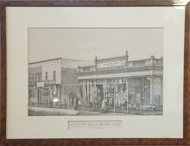
Work on paper, Francois Cogne, Part of Main Road 1859
When this court house was abandoned it became the site of the Ballarat School of Mines, the first School of Mines in Austalasia. Francois Cogne was born in 1829 in Paris. He worked in Australia between 1856 and 1864. He died in 1884.Framed lithograph of the former Ballarat Circuit Court.francois cogne, biggs and shoppee, main road -
 Mt Dandenong & District Historical Society Inc.
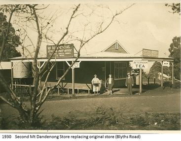
Photograph, Mt Dandenong Store, 1930
... pictured was on the corner of Helen Street and the Main Road... Store on the corner of Helen Street and the Main Road in 1930... pictured was on the corner of Helen Street and the Main Road ...Image shows the Mt Dandenong Store and Post Office that replaced the former Post office and Store that was located on the corner of Old Coach and Farndons Roads. The store relocated following the opening of the new Main Road in 1926. The store pictured was on the corner of Helen Street and the Main Road. The image was taken in 1930. The photograph was taken by a member of the Dower family.Donated as a jpeg digital image that shows the Mt Dandenong Store on the corner of Helen Street and the Main Road in 1930. Two women and a man are standing at the front. Signs advertising the Store & Post Office, Age and Argus are clearly visible on top of the verandah.Front of image: 1930 Second Mt Dandenong Store replacing original store (Blyths Road)mt dandenong, post office, store, mt dandenong store, main road -
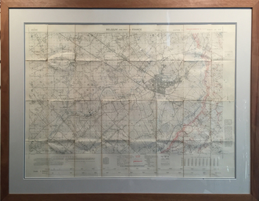 Tramways/East Melbourne RSL Sub Branch - RSL Victoria Listing id: 27511
Map and Legend, Trench Map - France Sheet 36 N.W
This is an actual battle map used by Australian Forces in the battle of the Somme in France in April 1917. It is an ordinance survey map of the trenches in the area. It is framed in two pieces, one being the main map and the other the legend used to read the map. It details the river 'La Lys Riviera' and the city 'Armentieres', in the Somme. somme, trench map, ww1, belgium, france, armentieres, 1917, ordinance survey map