Showing 188164 items matching "main-street"
-
 Greensborough Historical Society
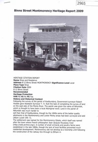
Document, Banyule City Council, Binns Street Montmorency heritage Report 2009, 27/06/2011
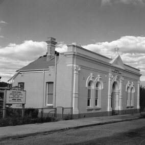
Heritage citation report for the shop and residence at 8-12 Binns Street Montmorency3 p., typescript and black and white photographbinns street montmorency, montmorency -
 Tatura Irrigation & Wartime Camps Museum
Photograph, Water Tower Kerford Street Tatura
Shows picture of the original Water Tower, which was situated in Kerford Street, Tatura. Sepia photograph showing the original water tower. Photograph stuck onto piece of white cardboard. tatura victoria, water tower tatura, kerford street tatura -
 Stawell Historical Society Inc
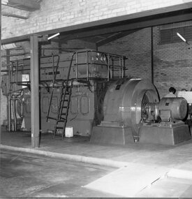
Photograph, Stawell Power House Interior in Sloane Street supplying Electric Power Supply for the town of Stawell
Interior of the Power House Sloane Street. Electric Power Supply for the town of Stawell.stawell electricity power -
 Stawell Historical Society Inc
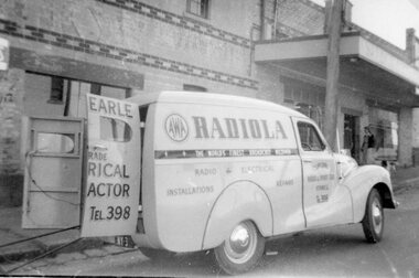
Photograph, Mr Cliff Earle's Radio and Electrical Contractor vehicle in Wimmera Street c1950's
Cliff Earle - Radio and Electrical Contractor vehicle . Wimmera Street 1950'sstawell -
 Stawell Historical Society Inc
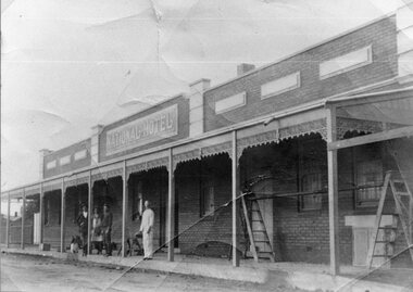
Photograph, M Jim Willoby and Mr Reece Unknown painting the National Hotel in Wakeham Street Stawell c1900
Jim Willoby and Reece painting the National Hotel Wakeham Street Stawell c1900stawell -
 City of Ballarat Libraries
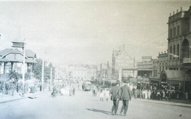
Photograph, Camp Street Gardens, Ballart circa 1916
Located in Sturt Street, the Titanic Bandstand, Mechanics' Institute and Sutton's can be seen.streetscape, public, commercial, hotel, titanic bandstand, mechanics' institute, suttons, sturt street, camp street gardens. -
 City of Ballarat Libraries
Photograph - Card Box Photographs, 628 Lyons Street South, Ballarat circa 1927
Healy family with Jack Eggleston out the front of 628 Lyons Street South.healy, jack eggleston, peel street south, ballarat, private dwelling, building, costume -
 City of Ballarat Libraries
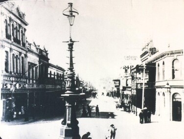
Photograph - Card Box Photographs, View east along Bridge Street, Ballarat circa 1890
Along the street are Cocking & Skewes, the Bucks Head Hotel and C. Morris, Hatter.bridge street, cocking & skewes, bucks head hotel, c.morris, streetscape, street lamp, commerical, building, vehicle -
 Stawell Historical Society Inc
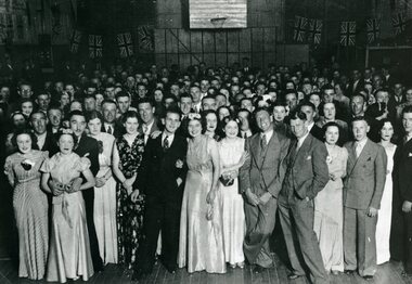
Photograph, Large Group of Dancers in the Army Drill Hall in Sloane Street Stawell 1937
Large Group of Dancers in Army Drill Hall 1937 Sloane Street Stawell.stawell -
 Stawell Historical Society Inc
Photograph, Stawell Technical School with the Original Tech School Façade in Skene Street 1967
Stawell Technical School Original Tech School Façade Skene Street. 1967stawell education -
 Stawell Historical Society Inc
Photograph, Stawell Technical School showing the Quadrangle in the school yard looking towards Skene Street
Stawell Technical School. Quadrangle in school yard looking towards Skene Street.stawell education -
 Stawell Historical Society Inc
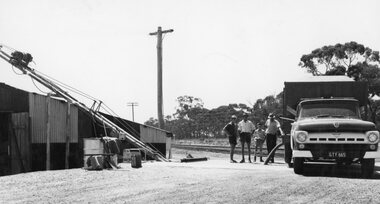
Photograph, Grain Storage Site beside railway line in Griffin Street with a truck unloading
Grain Storage Site beside railway line Griffin Street truck unloading.stawell -
 Stawell Historical Society Inc
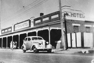
Photograph, National Hotel in Wakeham Street Stawell with a wedding vehicle parked in front c1940
National Hotel with wedding vehicle parked in front Wakeham Street Stawell c1940stawell -
 Stawell Historical Society Inc
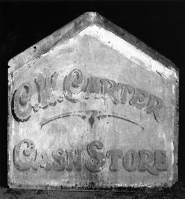
Photograph, Advertising Sign from the top of Mr Charlie Carter’s Grocery Shop in Lamont Street Stawell
Sign from top of Charlie Carter’s Grocery Shop - Lamont Street Stawellstawell business -
 Stawell Historical Society Inc
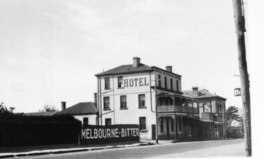
Photograph, Royal Exchange Hotel & Court House in Patrick Street Stawell 1930
Royal Exchange Hotel Stawell with Court House in Patrick Street Stawell 1930stawell -
 Stawell Historical Society Inc
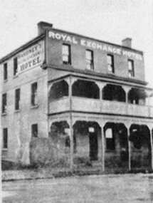
Photograph, Royal Exchange Hotel with a verandah in Patrick Street Stawell near Court House
Royal Exchange Hotel with Verandah Patrick Street Stawell near Court Housestawell -
 Stawell Historical Society Inc
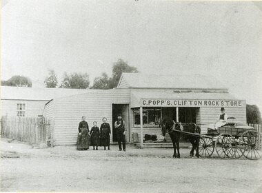
Photograph, Mr C. Popp’s Clifton Rock Store on the corner of Newington Road & Sophia Street
Clifton Rock Store (C. Popp’s) Cnr Newington Road and Sophia Streetstawell business -
 Stawell Historical Society Inc
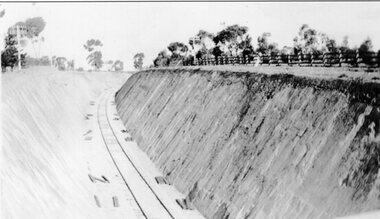
Photograph, Railway Cutting 1930's looking South -- running parallel to Napier Street
Railways cutting 1930's looking south running parallel to Napier Street.stawell railways transport -
 Eltham District Historical Society Inc
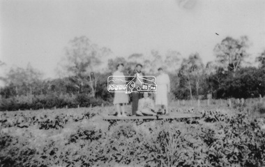
Photograph, At Bell Street, Eltham; from left: Helen Skipper, Matcham Skipper, Sonia Skipper and possibly Myra Skipper
At Bell Street, Fabbro Farm, Eltham; From left: Helen Skipper, Matcham Skipper, Sonia Skipper and possibly Myra Skipper, standing in the middle of a vegetable crop. The site of the Fabbro farm (Diamond Creek side land) is now called Barrack Bushlands. It is doubtful that Fabbro's farm holding was ever called Barrak Park, This title is fairly recent after the Shire of Eltham purchased the land, including the last section in 1993/94. About this time the area on the west side of Falkiner Street was purchased by a private developer and developed as housing. The area in Bell Street opposite the Eltham High School was purchased by the State Government is recent years and is called Fabbro Fields. The Fabbro Family operated their farm in Bell Street, Eltham. 1 black and white photographfabbro's farm, bell street, eltham, farming, helen skipper, vegetables, matchcam skipper, myra skipper, sonia skipper -
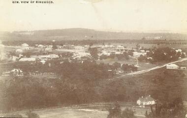 Ringwood and District Historical Society
Photograph, View of Ringwood in 1912 taken from Loughnan's Hill
Black and white photograph looking across valley with small settlement. Mountains in background. (2 postcard copies and 2 enlargements). House in right foreground is in what is known now as Wildwood Grove. The dirt track above is Ringwood St. Field above is the football field with diagonal track coming out at Melbourne Street, later Eastland shopping complex. House on left is in Adelaide Street. Warrandyte Road is above it."Typed on back of one enlargement, "Copied from a postcard mailed in Ringwood, 1912, copied 1959. House in right foreground is in what is known now as Wildwood Grove. The dirt track above is Ringwood St. Field above is the present football field with diagonal track coming out at Melbourne Street. House on left is in Adelaide Street. Warrandyte Road is above it." House bottom RH side was still there in 1970 in Wildwood Grove (off Ringwood St). Ringwood Street lower centre to RH side. Field above Ringwood Street is the football field with diag. walk coming out at Melbourne Street. House on LH side in Adelaide Street. Warrandyte above it. Steam at LH from Bently's Steam Joinery at corner Main Street and Warrandyte Road. -
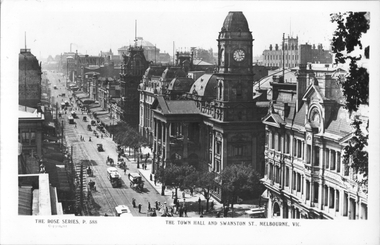 Melbourne Tram Museum
Postcard, Rose Stereograph Co, "The Town Hall Swanston Street Melbourne", c1900
Rose Series postcard No. P 588 titled "The Town Hall Swanston Street Melbourne", looking north along Swanston St. Has at least eight cable tams in the view, along with many horse-drawn vehicles. The building on the right is the Queen Victoria Building on the corner of Collins Street. Yields information about Swanston St and the Melbourne Town Hall, c1900Postcard - printed real photograph with Rose Stereograph Co. name on the rear.trams, tramways, swanston st, cable trams, melbourne town hall, collins st -
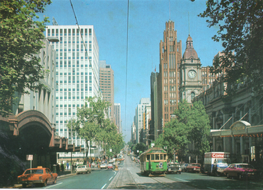 Melbourne Tram Museum
Postcard, Rose Stereograph Co, "Beautiful Collins Street", mid 1970s
Photo of Collins Street from west of Russell Street with the Regent Theatre, the Athenaeum Theatre, Wales House, the Manchester Unity building, and the Melbourne Town Hall in the view. W2 class No 645 bound for Mont Albert on route 42 is eastbound. The City Square can be seen on the left side. Yields information about Collins St mid to late 1970s.Colour postcard by Rose Stereograph Co. No. 1674postcards, collins st, w2 class, city square, melbourne town hall, tramways, trams, route 42, tram 645 -
Tatura Irrigation & Wartime Camps Museum
Photograph, Clock Tower Tatura, 1950
Photogrpah of memorial clock tower, built 1940 in memory of Dr J. Park. Money raised by public subscription, built by W. J. Montgomery. Cost - clock tower 168 pounds 15 shillings; electric clock 34 pounds 5 shillings.Black and white photograph of clock tower, Hogan Street, Tatura.on back: Clock Tower Hogan Street Tatura 1950dr j. park, monuments tatura -
 Federation University Historical Collection
Plans, Plans of the Ballarat School of Mines, Lydiard Street South, Ballarat, 1953
.3) Ballarat School of Mines plan for water supply installation to prefabricated classrooms associated with the Ballarat Girls' Techncial School, April 1953 .4) Ballarat School of Mines plans for three prefabricated classrooms to be used as the Ballarat Girls' Techncial School, Hickman Street, Ballarat by Percy E. Everett, 16 December 1952. Earthworks undertaken by T.G. James. .5) Ballarat Sewerage Authority Plan of Drainage Prefabricated Class Rooms Ballarat School of Mines by Chief Architect Percy E. Everett, 13 April 1953. The plan shows basket ball court and shelter, classrooms, contours, excavations and girls toilet associated with the Ballarat Girls' Techncial School, Hickman Street, Ballarat. ballarat junior girls' technical school, ballarat girls' technical school, ballarat school of mines, hickman street, white flat, t.g. james -
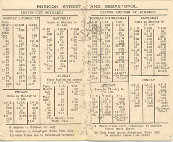 Ballarat Tramway Museum
Ephemera - Timetable/s, Electric Supply Co. of Vic (ESCo), "Ballarat Tramways Rubicon Street and Sebastopol Time Table.", 1920's
Demonstrates aspects of the Ballarat Tramways in providing information to the travelling public about their tram services, times and how organised in relation to the time of the day. An ESCo era timetable. Two local businesses have advertised as well.Folded printed card, off white, titled "Ballarat Tramways Rubicon Street and Sebastopol Time Table." Gives details of trams from the City for Rubicon St and Sebastopol for the various days and inbound trams from Rubicon, indicating that trams ex Sebastopol ran 10 minutes earlier. Has various notes on the timetable. On Front of card, has advertisements for R. Hutchinson - 29 Armstrong St Ballarat, auto electrician and Suttons Ltd - Musical instruments - Corner Sturt and Dawson Streets. An ESCo produced timetable - 1920's, as the SECV used "Grey St" instead of Rubicon St. (Email from Alan Bradley 8/2006). Copy of email with worksheet.Pencil marks on the cover - about tram services etc. g "Ten to the hour Aunties will catch the tram up at Sturt St"timetables, sebastopol, rubicon st, r. hutchinson, suttons, esco -
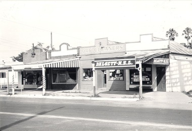 Wodonga & District Historical Society Inc
Photograph - Mann Collection Album - DALGETY N.Z.L, High Street West - corner of Melbourne Road to Railway, C. 1960s
Elaine Mann was married to David Mann, a successful Wodonga businessman and community leader who passed away in Wodonga in June 2012. David was a member of the Mann family who began their business in Wodonga in 1920. Elaine was a teacher in Wodonga for many years and an active member of the community.This photo collection is of significance as it documents how the businesses and buildings in Wodonga have evolved and contributed to community throughout the late 20th century.Dalgety-N.Z.L in High Street West - corner of Melbourne Road to the railway line. Businesses include a barber, dry cleaners and Dalgety-N.Z.L. Dalgety and Company Limited merged in November 1961 with New Zealand Loan and Mercantile Agency Company Limited, one of its principal competitors in Australia's eastern states and New Zealand. As of 30 June 1970, the business name Dalgety New Zealand Loan was delisted, with the company becoming Dalgety Limited. This information dates the photo as being taken between 1961 and June 1970. This site later became Wodonga Home Furnishers. The building was demolished in November 1998 to make way for the realignment of Elgin Street to join what was then Jack Hore Place. wodonga businesses, high st wodonga, railway crossing, dalgety -
 Eltham District Historical Society Inc
Document - Building Plan, J.M. Harcourt, 22 Peter Street, Eltham, c.1946
Pise or Adobe Brick Cottage for Mr D. Sawer in Peter St., Eltham Design and drawings by J.M. Harcourt, Clay Nuneham, Eltham. The cottage at present day 22 Peter Street was built circa 1946. Also Drawing of planned carport and future extension for 22 Peter Street, Eltham22 peter street, building plans, clay nuneham, d. sawer, eltham, j.m. harcourt design, adobe house, j.m. harcourt designc.1946, pise house -
 Eltham District Historical Society Inc
Slide, Andrews Street, Eltham, c. Jan 1983
Roll of film taken by Eltham Shire Council officers of the Beard street group, a private street scheme, before construction commenced. They provide perspective of the changes in housing styles and road development that began sweeping in from the mid 1970s with increasing urbanisation of what was once more outlying suburbs and regions.35 mm colour positive transparency (1 of 7) Mount - Blank Card,eltham, housing estate, infrastructure, private street scheme, roads, andrews street -
 Eltham District Historical Society Inc
Slide, Thomas Street, Eltham, c. Jan 1983
Roll of film taken by Eltham Shire Council officers of the Beard street group, a private street scheme, before construction commenced. They provide perspective of the changes in housing styles and road development that began sweeping in from the mid 1970s with increasing urbanisation of what was once more outlying suburbs and regions.35 mm colour positive transparency (1 of 7) Mount - Blank Card,eltham, housing estate, infrastructure, private street scheme, roads, thomas street -
 Eltham District Historical Society Inc
Slide, Andrews Street, Eltham, c. Jan 1983
Roll of film taken by Eltham Shire Council officers of the Beard street group, a private street scheme, before construction commenced. They provide perspective of the changes in housing styles and road development that began sweeping in from the mid 1970s with increasing urbanisation of what was once more outlying suburbs and regions.35 mm colour positive transparency (1 of 7) Mount - Blank Card,eltham, housing estate, infrastructure, private street scheme, roads, andrews street