Showing 4566 items
matching tram 1
-
 Bendigo Historical Society Inc.
Document - BASIL MILLER COLLECTION: TRAMS - TICKETS
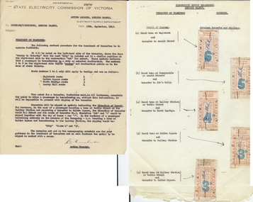
State Electricity commission of Victoria Notice to Motorman and Conductors of Bendigo Branch relating to the treatment of transfers. Page 1 - one type written, Page B explains new method of clipping transfers showing sample tickets. Inscriptions: All tickets have cancelled, written in biro, across the front.person, individual, basil miller -
 Bendigo Historical Society Inc.
Document - BASIL MILLER COLLECTION: TRAMS - TICKETS
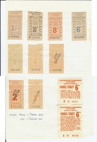
Mounted examples of tram tickets that were issued from 1st March 1963 - 1st October 1965. Examples include: 2d. City section, 3d, concession, 3d city section, 4d., 5d., 6d., 8d., 10d., 1 shilling and two 6d. Parcel tickets. Inscriptions: Dates of issue opened bottom left of page 'B'.person, individual, basil miller -
 Bendigo Historical Society Inc.
Document - BASIL MILLER COLLECTION: TRAMS TICKETS
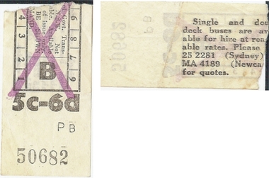
... One(1) New South Wales tram ticket, 5c-6d(five cents... PERSON Individual basil miller One(1) New South Wales tram ticket ...One(1) New South Wales tram ticket, 5c-6d(five cents or sixpence), No. PB50682.Printed in black with a mauve cross placed over the printing on the front.person, individual, basil miller -
 Bendigo Historical Society Inc.
Document - BASIL MILLER COLLECTION: TRAMS TICKETS
Twelve(12) State Electricity Commission of Victoria Provincial Tramways tickets. Eight(9) 8d(eight pence) tickets printed in red, Nos. C668538, C667380, C668542, C668543, C66544, C668545, C668546. Three(3) 10d(ten pence) tickets printed in black, Nos. A747804, A747805, A747806. One(1) 1/-(one shilling) ticket printed in mauve, No. A592800. One 1/3d(one shilling and threepence) No. Csg 074933.person, individual, basil miller -
 Bendigo Historical Society Inc.
Document - BASIL MILLER COLLECTION: TRAMS TICKETS
Sixteen(16) State Electricity Commission of Victoria, Provincial Tramways tickets. Six(6) 4d(four pence) tickets, printed in orange, Nos. Y583200, Z207005, Z207006, Z207007, Z207008, and Z207009. Eight(8) 5d(five pence) tickets, printed in green, Nos. B886001, B886002, B886003, B886004, B886005, and B886008.Three(3) 6d(six pence) tickets printed in blue, one faded, Nos. B637746, B652004, and L650000. One(1) 7d(seven pence) ticket, printed in black, No. C469000.person, individual, basil miller -
 Bendigo Historical Society Inc.
Document - BASIL MILLER COLLECTION: TRAMS TICKETS
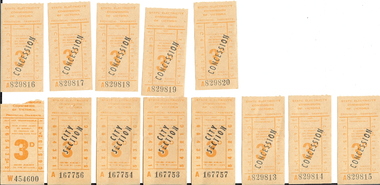
Eleven(11) State Electricity Commission of Victoria Provincial Tramways, 3d(three pence), tickets. One(1) ordinary ticket, No. W454600. Two(2) ordinary tickets over stamped City Section in black, Nos. A167754 and A167756. Eight(8) ordinary tickets over stamped Concession in black, Nos. A829813, A829814, A829815, A829816, A829817, A829818, A829819, and A829820.person, individual, basil miller -
 Bendigo Historical Society Inc.
Document - BASIL MILLER COLLECTION: TRAMS TICKETS
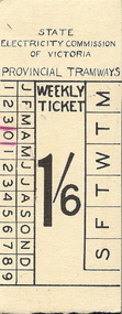
One(1) 1/6d (one shilling and sixpence) State Electricity Commission of Victoria, Provincial Tramways weekly ticket. Front of ticket also indicates months of year and days of week. All printing is in black ink.person, individual, basil miller -
 Bendigo Historical Society Inc.
Document - BASIL MILLER COLLECTION: TRAMS TICKETS
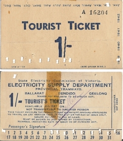
One 1/- (one shilling) State electricity Commission of Victoria, Electricity Supply Department, Provincial Tramways tourist's Ticket. No. A15204. This ticket has been used and been cancelled by a handwritten and underlined word Cancelled, in purple colour. Note the clipped marks at the bottom edge made by the Conductors 'nipper'. A piece of adhesive tape has been placed from the top on the face of the ticket. All printing on the face and the reverse side may be viewed on the scans attached.person, individual, basil miller -
 Bendigo Historical Society Inc.
Document - BASIL MILLER COLLECTION: TRAMS PARCEL TICKETS
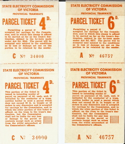
Two(2) State electricity Commission of Victoria Parcel tickets. One at 4d(four pence) No.C34000 and One(1) at 6d(six pence) No. A46757. Each ticket comprises of receipt to sender, (bottom half), and top half is adhered to the parcel using adhesive patch on reverse. All markings and printings are in red ink.person, individual, basil miller -
 Bendigo Historical Society Inc.
Document - BASIL MILLER COLLECTION: TRAMS, TIMETABLE
Transparent blueprint paper. Electricity Supply Department, Bendigo Branch. Time table - Eaglehawk route Friday 20 minutes until 11.50 am, then 10 mins. Service. Run No.1 to No.7.organization, business, bendigo trams -
 Bendigo Historical Society Inc.
Document - BASIL MILLER COLLECTION: TRAMS - SET THREE TICKET BOOKS
1. Brown leather ticket book, some of binding stapled together. 2. Brown leather ticket book, paper labels stick to the inside, some notations. 3. Brown leather ticket book, with pockets. Inscriptions: 1. 29(circled) on front top left corner. 2. Peeling labels inside, some notations.person, individual, basil miller -
 Bendigo Historical Society Inc.
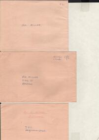
Document - BASIL MILLER COLLECTION: TRAMS - ENVELOPES
Three (3) buff envelopes. 1. Addressed 'Mr Miller'. 5/- written in top right corner. 2. Addressed 'Mr Miller' King Street Bendigo. 26x4s, 16x8s, 17/6 in top right corner. 3. Addressed 'Mr B Miller' tramways, SEC, Hargreaves Street. Reverse of 3. Remnants of adhesive tape on closing flap.person, individual, basil miller -
 Bendigo Historical Society Inc.
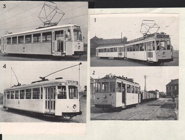
Document - BASIL MILLER COLLECTION: TRAMS - PHOTOS
Two cuttings, each with two photos of trams. The photos are numbered 1 - 4. Possibly German trams.Remnants of printing on reverse of both pieces.person, individual, basil miller -
Bendigo Historical Society Inc.
Document - BASIL MILLER COLLECTION: TRAMS - VARIOUS TIMETABLES
1. Monday to Friday - Eaglehawk, Quarry Hill, Golden Square, North Bendigo routes. 2. The Electric Supply Company of Victoria Ltd Bendigo and Eaglehawk Tramways, Sixteen (16) Copies. 3. The Electric Supply company of Victoria Ltd, Northern Branch alteration to fares, 1969. 4. Electricity Supply Department Bendigo - amended timetables - 1955, Six (6) copies. 5. Staff shift timetable - weekdays and Saturday - Two (2) pieces.person, individual, basil miller -
 Bendigo Historical Society Inc.
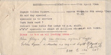
Document - BASIL MILLER COLLECTION: EASTER MONDAY, 11 APRIL 1966, c1966
Typed document. Heading: Easter Monday 11 April 1966. Body: Bogeys Golden Square, approx 11-05 to Nth every 15 mins. No midday special. Specials in to service. Turn Back card? Collect time table for issue to pm. Shift. a'b'c'' specials to shunt at Mollison street at all times. (in red) Discs to be on all leading trams. (in pencil) Red flags for car summer against traffic Golden Square intersection no signal light? (Myrtle St) (Miller St) . 5am to 1 pm Sat.organization, business, bendigo trams -
 Bendigo Historical Society Inc.
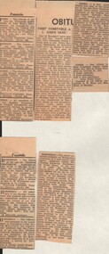
Document - BASIL MILLER COLLECTION: TRAMS - POLICE - HARDIMAN AND JONES
Newspaper clippings, date unknown, re the death of Thomas Frederick Hardiman, 3 death notices and 1 obituary. In the case of Joseph Lewis Jones, Policeman, there are 2 notices, 1 obituary, and 2 funeral notices.person, individual, basil miller -
 Bendigo Historical Society Inc.
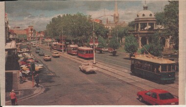
Document - BASIL MILLER COLLECTION: TRAMS - COLOUR PHOT OF TRAMS IN PALL MALL
Clipping, date unknown, of colour photograph showing 5 trams on Pall Mall. Four (4) red colour and one (1) green.person, individual, basil miller -
 Bendigo Historical Society Inc.
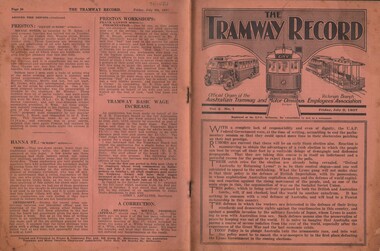
Document - BASIL MILLER COLLECTION: TRAMS - THE TRAMWAY RECORD
Journal of Australian Tramway Employee Association. Volume 2, No. 1. Friday July 9 1937. 24 pages.person, individual, basil miller -
 Bendigo Historical Society Inc.
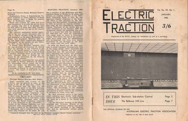
Document - BASIL MILLER COLLECTION: TRAMS - JOURNAL 'ELECTRIC TRACTION', Janaury 1964
Journal of Australian Electric Traction Association. Volume XIX, No. 1, January 1964. 16 pages. History of document: Part of 'Basil Miller Collection'. Cover picture was a seven-car suburban electric train of original "swing door" rolling stock passing through parklands in the suburb of Burnley on its way to Melbourne.Pub: Australian Electric Traction Asscn. Printer: O'Loughlin Bros. Pty. Ltd., Sydney NSWdocument -
 Bendigo Historical Society Inc.
Document - BASIL MILLER COLLECTION: TRAMS - JOURNAL 'ELECTRIC TRACTION', January 1965
Journal of Australian Electric Traction Association. Volume XX, No. 1, January 1965, 16 pages. History of document: Part of 'Basil Miller Tramways Collection'. Cover picture shows the Melbourne and Metropolitan Tramway Board's new supervisory electrical control room at Carlton near city. This photograph was taken during a visit to the incomplete centre during the A.E.T.A.'s Easter Convention, 1964.Pub: Australian Electric Traction Association, Printer: O'Loughlin Bros. Pty. Ltd., Sydney NSWdocument -
 Bendigo Historical Society Inc.
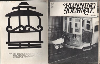
Document - BASIL MILLER COLLECTION: TRAMS - 'RUNNING JOURNAL'
Journal of the Tramway Museum Society of Victoria. Ltd. Volume 8, No.1, February 1971. 30 cents. 16 pages. (Right) a pram on the front of a Perth tramcar was a common sight and so Tony Cooke placed one on his half ince to the foot model of (2nd) A class no. 121 which operated at the 1971 Tramway Exhibition during Moomba (D. Mcartney). The back cover (left) shows new logo for the Tramway Museum, designed by John Milne.person, individual, basil miller -
 Bendigo Historical Society Inc.
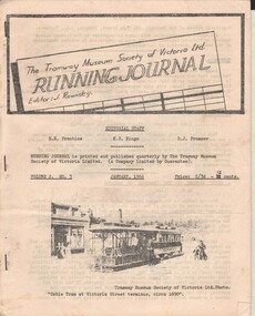
Document - BASIL MILLER COLLECTION: TRAMS - 'RUNNING JOURNAL', January, 1966
Journal of the Tramway Museum Society of Victoria. Ltd., Volume 2, No. 3 January 1966. 1/3d (12 cents). Front page picture of cable tram at Victoria Street terminus, circa 1890. Thirteen pages. History of document: Part of 'Basil Miller Tramways Collection'document, newspaper -
 Bendigo Historical Society Inc.
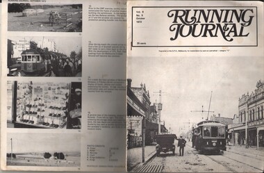
Document - BASIL MILLER COLLECTION: TRAMS - 'RUNNING JOURNAL'
Journal of the Tramway Museum Society of Victoria Ltd. Volume 9, No.5, 35 cents, October 1972. 16 pages. Front cover picture (right) shows car no. 1 of Prahran and Malvern Tramways Trust fleet in High Street Malvern. The P&M T T commenced in 1910 with some four and a half route miles along High Street, Glenferrie Road and Wattletree Road. When absorbed by the M&M T B in 1920 its routes totalled over 35 miles.person, individual, basil miller -
 Bendigo Historical Society Inc.
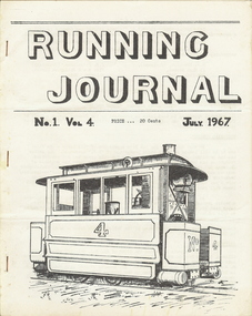
Document - BASIL MILLER COLLECTION: TRAMS - 'RUNNING JOURNAL'
Journal of the Tramway Museum Society of Vic. Ltd. Volume 4, No.1, July 1967, 20 cents. 12 pages.person, individual, basil miller -
 Bendigo Historical Society Inc.
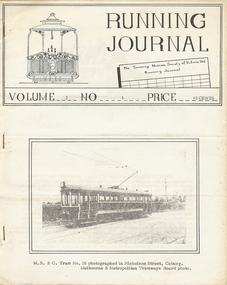
Document - BASIL MILLER COLLECTION: TRAMS - 'RUNNING JOURNAL'
Journal of the Tramway Museum Society of Vic. Ltd. Volume 3, No.1, 12 cents. 20 pages.person, individual, basil miller -
 Bendigo Historical Society Inc.
Document - BASIL MILLER COLLECTION: TRAMS- 'RUNNING JOURNAL'
Journal of the Tramways Museum Society of Vic. Ltd. Volume 6, No.1, August 1969. 30 Cents. 16 pages.person, individual, basil miller -
 Bendigo Historical Society Inc.
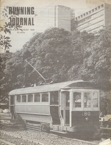
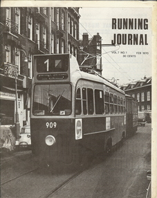
Document - BASIL MILLER COLLECTION: TRAMS - 'RUNNING JOURNAL'
Journal of the Tramways Museum Society of Vic. Ltd. Volume 7, No. 1, Feb 1970. 30 cents. 16 pages.person, individual, basil miller -
 Bendigo Historical Society Inc.
Ephemera - KEN HESSE COLLECTION: TRAM TICKETS, ENTRY TICKETS, INVITATION, GAME
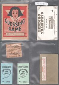
1) Red and white guessing game card in the name of Betty Nankervis giving the correct number of answers:11. When opened there are 20 questions on parts of the human anatomy with space for answers. 2) Bendigo Tramways card first issued December 9 & 10 1972 the name Mrs K. Hesse typed above the picture of a tram. Linking unique tourist attractions, a project of the Bendigo Trust. On the back a signature R.F. Lamb(?) 3) Two tickets Electricity supply department provincial tramways, this ticket is issued subject to the by-laws, price 1 penny. 4) Two entry tickets to Bendigo pottery Australia's oldest pottery workshop, one family for $1.40 and one adult for 50centts. 5) Brown paper rectangular box in the middle: Manchuria, twelve different stamps issued by the Japanese puppet government of Manchuria and the north-east provinces under the control of the Chinese Nationalist Government. -
 Tramway Heritage Centre
Photograph Album (part of), Ray Pearson's Photo Album - Trams of Victorian Railways, Ballarat, Bendigo, Geelong
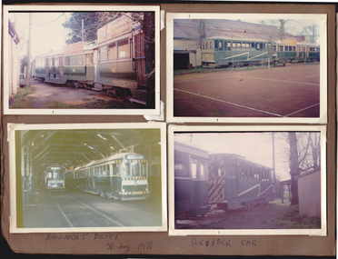
Inside cover page of Ray Pearson's Photo Album. Brown card page with four photographs (landscape format) placed on page using clear plastic photo corners. All photographs depict trams at the Ballarat depot. The photo corner plastic is perishing and one photograph (top left) is loose on the page. The remaining three photographs remain in place, though not securely. Hand written inscriptions are written under the bottom two photographs and also appear on the back of the loose photograph.Hand written incription in biro at base of page, under bottom two photographs. Left: BALLARAT DEPOT / 20 Aug. 1971 Right: SCRUBBER CAR To back of loose photograph - In top left corner with text seperated by underline: 1/A / End of film To centre: Bogie Cars / Maxim Traction / Ballarat Depot / 20th Aug 1971 / No 39 + No 43 / Both Ec PMTT Repeat text patterm is printed on photopaper: A KODAK PAPER Three faded red ink stamps depicting a rectangular logo: This is a / KODAKCOLOR PRINT Beneath logo: SEPT. 71-M -
 Tramway Heritage Centre
Photograph Album (part of), Ray Pearson's Photo Album - Trams of Victorian Railways, Ballarat, Bendigo, Geelong
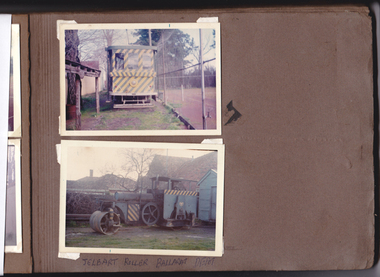
Page 1 of Ray Pearson's photo album. Brown card page with two photographs (landscape format) placed on page using clear plastic photo corners. The top photo depicts a scrubber tram and the bottom a 'Jelbart Roller' tram at the Ballarat tram depot. The photo corner plastic is perishing and both photographs are loose on the page. A hand written inscription is written under the bottom photograph and inscriptions also appear on the back of both photos.Hand written inscription in biro at base of page, under bottom photograph: JELBART ROLLER BALLARAT DEPOT To back of loose photograph at top of page: In top left corner with an underline: 4 To centre: Front of Scrubber Tram / Ballarat Depot / 20th Aug 1971 / Sebastapol lyte Car To back of loose photograph at bottom of page: In top left corner with an underline: 6 To centre: Jelbart Roler SEC / Tram Depot Ballarat / 20th Aug 1971