Showing 2286 items matching " parish."
-
 Bendigo Historical Society Inc.
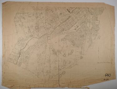
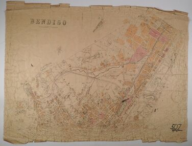
Map - BENDIGO SHEET 2, Circa 1900
Map: Bendigo sheet 2 . Parish planmap, bendigo, parish plan, bendigo -
 Bendigo Historical Society Inc.
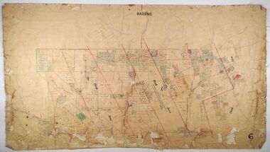
Map - MARONG, Circa 1871
Map; Marong, Hand Draughted parish planmap, bendigo, parish plan, marong -
 Bendigo Historical Society Inc.
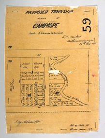
Map - PROPOSED TOWNSHIP PARISH OF CAMPASPE, 24th May 1875
Map: Proposed Township, Parish of Campaspe(This has been crossed out and 'Creek View' written above). Hand Draughted Parish plan Stapled to the backingmap, township, proposed township, campaspe, creek view -
 City of Moorabbin Historical Society (Operating the Box Cottage Museum)
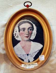
Print - Mary Ann Charman 1820 - 1870
Mary Ann Charman was a pioneer settler in the Cheltenham area of the Parish of Moorabbin c1850 Stephen Charman , who emigrated in 1942 as a Henry Dendy employee aged 21 years, sadly lost his wife and child shortly after arriving in Brighton. When Dendy could not employ him he found other work. In 1850 he met Mary Gettens a widow with 5 children who supported her family by managing her late husband’s Inn in Collins St. Melbourne. Stephen purchased land in Spring Grove, now Cheltenham, in 1852 and the family moved to the wattle and daub hut after their marriage. Mary and Stephen worked very hard to establish a market garden, poultry and pork farm . They specialised in Marigolds which they sold to Martin & Pleasance Pharmacy , Melbourne for medicinal purposes. Mary and Stephen had 7 more children and Mary still managed to find time to sell the pork, poultry and vegetables from a horse drawn cart she drove around St Kilda. 1857 Stephen donated land to the Methodist Church for a School, burial ground and Chapel in Balcombe Road. Mary died 1870. Stephen remarried in 1878 and died aged 85 years 1906. Charman Road runs from Nepean Highway , Cheltenham through Beaumaris to the Beach Road at Mentone. Mr Les Jones was the Great Grandson of Mary Ann CharmanAn oval framed colour copy of a painting of the likeness of Mary Ann Charman, 1820 - 1870 pioneer settler in the Cheltenham area of the Parish of Moorabbinpioneers, early settlers, dendy henry, charman mary ann, jones les, cheltenham, moorabbin, brighton, market gardeners, dairy farmers, charman road -
 Uniting Church Archives - Synod of Victoria
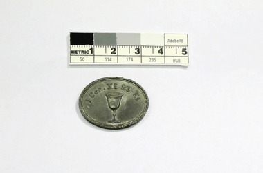
Communion token, c1855
Oval communion token. One side has a number 4 at its centre the other a chalice. There is text on both sides."PARISH CHURCH FORFAR 1855" "4" "I.COR.XI 23-2" -
 Falls Creek Historical Society
Plan - Leases of part of Falls Creek Tourist Area
Bob (Herman) Hymans (a former member of the Royal Netherlands Navy was born in Bloemendaal, Holland on 30th September 1922. During World War II he fought against the Japanese in the Dutch East Indies (now Indonesia) and was imprisoned in Changi and on the Burma Railway. After gaining qualifications as a Ski Instructor, Bob arrived in Falls Creek in May 1950. Working as an Instructor and Supervisor at Bogong Lodge, Bob decided his future was in accommodation. He was successful in negotiating an indenture for land from the State Electricity Commission (SEC). It took Bob two years to build his Grande Coeur Chalet but, tragically, it was burned down in August 1961. Bob also built the first Chairlift in Australia. This was a single chairlift and the structure was built from wooden electricity poles. He was constantly full of new ideas and proposals for the village. Bob Hymans died on 7th May 2007. This Collection of documents and letters tells the story of Bob’s endeavours to develop Falls Creek into the ski village it is today. This map is significant because it documents boundaries of early leases in Falls Creek Tourist Area.This map is part of Bob Hymans documents. It is a large Surveyor's Plan of a section of the Falls Creek Tourist Area. It is endorsed by J Parker, Chief Surveyor of the State Electricity Commission of Victoria on 27-3-84. It shows streets, lot numbers and measurements. It was a compilation created from existing lease maps. Heading - PART OF FALLS CREEK TOURIST AREA PART OF CROWN ALLOTMENT 1 PARISH OF CARRUNO PART OF CROWN ALLOTMENT 1 PARISH OF DARBALANG COUNTY OF BOGONGmap of falls creek, falls creek leases, falls creek 1980s -
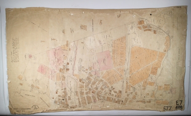
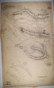
 Bendigo Historical Society Inc.
Map - BENDIGO SHEET 12, Reproduced 1961
Map; Bendigo Sheet 12, Parish of Sandhurst , County of Bendigo, Parish plan, Scale 2 chains to 1 inch ( number 142 in Map Cupboard 1)map, bendigo, city streets, bendigo sheet 12, parish of sandhurst , county of bendigo -
Bendigo Historical Society Inc.
Map - MANDURANG, 8/10/1887
Parish of Mandurang, County of Bendigo. Traced from a re-survey of the Parish of Mandurang by Mr. Geo. Black 8/10.1887 ( number 158 in Map Cupboard 1)map, bendigo, parish plan, mandurang, re-survey, couny of bendigo -
 Bendigo Historical Society Inc.
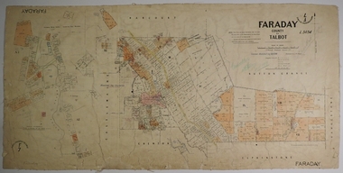
Map - FARADAY, 10/01/1879
Map: Parish of Faraday, County of Talbot. Parish plan. Draughtsman J T Thomson December 1877. Examined by J H Morgan 8/11/78map, talbot, parish plan, faraday, j. h. morgan, j. t. thomson -
 Linton and District Historical Society Inc
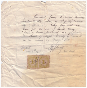
Receipt, Receipt for Payment for a Block of Land near Linton, 1918
Note that the block of land which was traded was not the block in Sussex Street, Linton on which the Sandows had a shop and house, but a block just outside the town boundary, near the Geelong Road (Linton-Naringhil Road). See map of Parish of Argyle for clarification.Photocopy of original handwritten receipt, which was for payment in full for a block of land situated just outside of Linton - Section A, Crown Allotment 1, Parish of Argyle. This land was purchased by Rubina (Ruby) Sandow from George Bolte in 1918. Receipt is for fifteen pounds, it is made out to "Rubinia Norwood Sandow" and is signed by Alf J. Smith, "for Geo. Bolte". Two Victorian Stamp Duty stamps are attached to the original document.rubina (ruby) sandow, george bolte, receipts, sale of land -
 Bendigo Historical Society Inc.
Map - JACK FLYNN COLLECTION: TARNAGULLA, 13/05/1922
Map: Parish of Tarnagulla . This Item is in very poor condition.By Authority, A. J. Mullen, Government Printer, Melbourne. Lithographed at the Department of Lands and Survey, Melbourne by W. J. Butsonmap, gladstone, parish plan, tarnagulla -
 Bendigo Historical Society Inc.
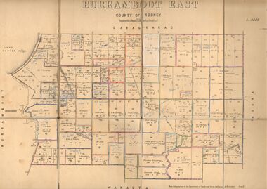
Map - JACK FLYNN COLLECTION: BURRUMBOOT EAST, 21/12/1027
Map: Burrumboot East, County of Rodney. Parish plan.Photo Lithographed at the Department of Lands and Survey, Melbourne by W.J.Butson. 21.12.27map, rodney, parish plan, burrumboot east -
 Bendigo Historical Society Inc.
Map - JACK FLYNN COLLECTION: ECHUCA NORTH, November 1953
Map: Echuca North, County of Rodney. Parish plan.By Authority: W.M. Houston, Government Printer. Drawn and Reproduced at the Dept., of Lands and Survey Melbourne, Victoria. November 1953map, rodney, parish plan, echuca north rodney -
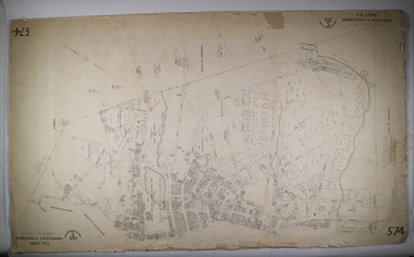
Bendigo Historical Society Inc.
Map - CITY OF SANDHURST SHEET NO.6, 25/04/1882
Map: City of Sandhurst sheet No. 6. Parish planmap, bendigo, parish plan, sandhurst -
 Robin Boyd Foundation
Slide, Robin Boyd, 1956-1957
Robin Boyd developed a close friendship with the founder of the Bauhaus in Weimar Germany, Walter Gropius, who had moved to the USA in the 1930s. Through this connection, Boyd was invited to be the Massachusetts Institute of Technology (MIT) Bemis Professor at the School in the North American academic year 1956-7. Robin and Patricia Boyd, with their youngest daughter Suzy, were based in Cambridge, Massachusetts for the year. Boyd gave some lectures at MIT and he was also invited to give lectures at many other universities, allowing him to travel widely within the USA, especially on the East Coast. This gave him the opportunity to meet architects like Frank Lloyd Wright, Eero Saarinen, Paul Rudolph and many others, and visit the offices of Skidmore, Owings and Merrill, and places like Taliesin and the General Motors Technical Center Detroit. On the way home, the Boyds visited London, Berlin, Paris and Le Corbusier’s Ronchamp Chapel in France.Colour slide in a mount. First Parish in Lexington, MAMade in USA / Patentedmit bemis professorship, mit, robin boyd, lexington, slide -
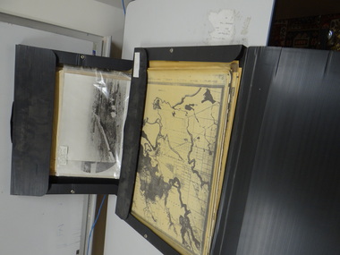 Brimbank City Council
2 x Black Folios
Old parish maps and photographs in two black folios. -
Stawell Historical Society Inc
Map, Agricultural Area of Lake Wilson, Parishes of Bellaura & Bellellen, 1865
Agricultural Area of Lake Wilson, Parishes of Bellaura & Bellellenstawell -
Stawell Historical Society Inc
Map, Country Lands Parishes of Drung Drung & Golton Golton, 1866
Country Lands Parishes of Drung Drung & Golton Golton stawell -
 Bendigo Historical Society Inc.
Map - BOROUGH OF EAGLEHAWK SHEET 2, 9/12/1902
Map: Borough of Eaglehawk, sheet No. 2. Parish planmap, bendigo, parish plan, borough of eaglehawk -
 Bendigo Historical Society Inc.
Map - BOROUGH OF EAGLEHAWK SHEET 2, 9/12/1902
Map: Borough of Eaglehawk, Sheet No, 2. Parish planmap, bendigo, parish plan, borough of eaglehawk -
 Bendigo Historical Society Inc.
Map - BOROUGH OF EAGLEHAWK SHEET 3, Circa 1880's
Map: Borough of Eaglehawk , sheet No. 3. Parish planmap, bendigo, parish plan, `borough of eaglhawk -
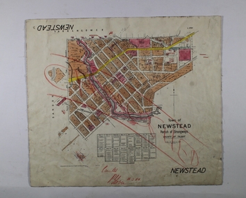 Bendigo Historical Society Inc.
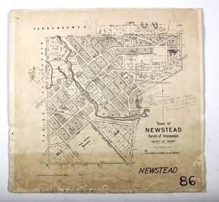
Map - NEWSTEAD, 1/11/1939
Map: Town of Newstead, Parish of Strangways, County of Talbotmap, talbot, township, newstead, parish of strangways, county of talbot -
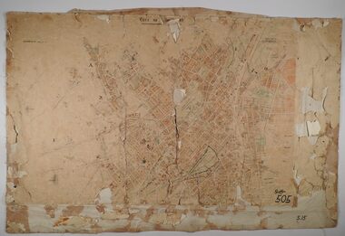 Bendigo Historical Society Inc.
Map - SANDHURST SHEETS 1 AND 2, No date visible
Map: Sandhurst sheets 1 and 2. Parish planmap, bendigo, parish plan, sandhurst -
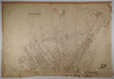 Bendigo Historical Society Inc.
Map - SANDHURST, No date Visible
Map: Parish plan showing the Northern section of the Municipalitymap, bendigo, parish plan, sandhurst -
 Bendigo Historical Society Inc.
Map - BENDIGO, No date visible
Map: Parish plan showing the Northern section of the Municipalitymap, bendigo, parish plan, bendigo -
 Bendigo Historical Society Inc.
Map - NEWSTEAD, 15/10/1912
Map: Town of Newstead, Parish of Strangways, County of Talbotmap, talbot, township, newstead, county of talbot -
 Ringwood and District Historical Society
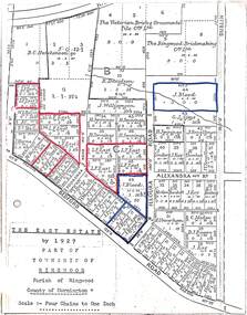
Map, The East Estate, Township of Ringwood, Victoria - 1927
Photocopied page - partial Parish map of Ringwood labeled The East Estate, showing street names and properties marked with names of individual owners or businesses.Page titled The East Estate by 1927 Part of Township of Ringwood, Parish of Ringwood, County of Mornington, Scale: Four Chains to One Inch. L.F. East blocks are marked by red outline. J. Blood blocks are marked by blue outline. Other names include B.C. Hutchinson & Co., The Victorian Brick & Ornamental Tile Coy., Ltd., The Ringwood Brickmaking Coy., Ltd., R. Davidson, J. Williamson, W.E. Bower, H. Jennings, G.J. Sims, J. Smallman, J. Horne, J. Lindsay, J. Kay, H. Unverhan, B.C. Hutchinson, M.A. Williamson, J.S. Woodworth, J. Price, C. Medew, S.W. Burchett, B.J. Hosking, D.J. Rogers, C. Wheeler, H. Frost, G.G. Miller, L. Winchcombe. Streets include Dublin Road, Illoura Road, Alexandra Road, and Bedford Road. -
Bendigo Historical Society Inc.
Map - LEICHARDT, 23/05/1875
Map: Parish of Leichardt, County of Bendigo. Parish plan (coloured). Attached plan in the top left hand corner marked 'Building Lots' (number 323 in map cupboard 1)map, bendigo, building lots, leichardt -
 Uniting Church Archives - Synod of Victoria
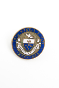
Badge
Blue and white enamel badge commemorating the centenary of the Wesleyan church in Fiji"THE WORLD IS MY PARISH" "LOTU WESELE E VITI" "1835-1935"methodist church -
Glenelg Shire Council Cultural Collection
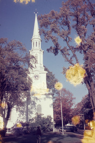
Photograph - Photograph - Sacred Heart Parish Church Casterton, c. 1963
SOURCED FROM CASTERTON TOWN HALL (FORMER SHIRE OF GLENELG) Sourced from Casterton Town Hall (Former Shire of Glenelg)Black and white photo, Sacred Heart Parish Church, CastertonBack: Black stamp '003826'