Showing 10961 items matching " plan"
-
 Rutherglen Historical Society
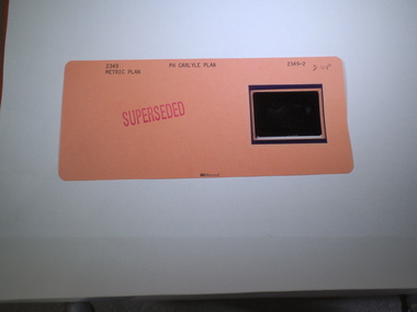
Aperture Card microfilm, Victorian Land Tiltes Office, Parish Plan Carlyle (Superseded)
Town layout of Carlylecard with a single microfilm insertplan, town, boundries, lots, roads -
 Rutherglen Historical Society
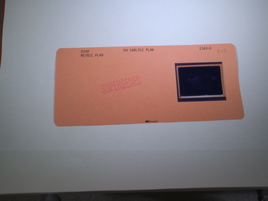
Aperture Card microfilm, Victorian Land Tiltes Office, Parish Plan Carlyle (Superseded)
Town layout of Carlylecard with a single microfilm insertplan, town, boundries, lots, roads -
 Rutherglen Historical Society
Aperture Card microfilm, Victorian Land Tiltes Office, Parish Plan Carlyle (Superseded)
Town layout of Carlylecard with a single microfilm insertplan, town, boundries, lots, roads -
 Rutherglen Historical Society
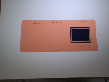
Aperture Card microfilm, Victorian Land Tiltes Office, Parish Plan Carlyle (Superseded), 11/07/2000
Town layout of Carlylecard with a single microfilm insertplan, town, boundries, lots, roads -
 Lakes Entrance Historical Society
Administrative Record - Documents, Community Heritage Plan Steering Committee, 1992
White two ring binder containing various documentation relating to East Gippsland Heritage Plan, 1992 to 1999books correspondence -
 Whitehorse Historical Society Inc.
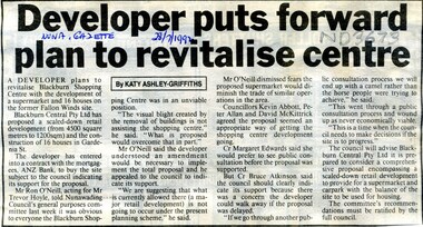
Article, Developer puts forward plan to revitalise centre, 1992
A plan by developer Blackburn Central Pty Ltd proposing a scaled down retail development for Gardenia Street site.A plan by developer Blackburn Central Pty Ltd proposing a scaled down retail development for Gardenia Street site.A plan by developer Blackburn Central Pty Ltd proposing a scaled down retail development for Gardenia Street site.blackburn station shopping centre, blackburn central pty ltd -
Whitehorse Historical Society Inc.
Article, New Plan for Servo, 2015
A developer has lodged plans with Whitehorse Council for a three-storey building on the former Caltex site on Blackburn Road.A developer has lodged plans with Whitehorse Council for a three-storey building on the former Caltex site on Blackburn Road.A developer has lodged plans with Whitehorse Council for a three-storey building on the former Caltex site on Blackburn Road.blackburn road, blackburn, blackburn village shopping centre, service stations -
 Whitehorse Historical Society Inc.
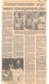
Article, Conservationists to urge weed management plan, 5/04/1989 12:00:00 AM
Article from Nunawading Gazette dated 5 April 1989 about a weed management plan in the City of Nunawading.environment, weeds, victoria. department of conservation, forests and lands., native plants, edwards, margaret, meagher, dorothy, witherspoon, cameron, david -
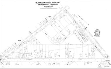
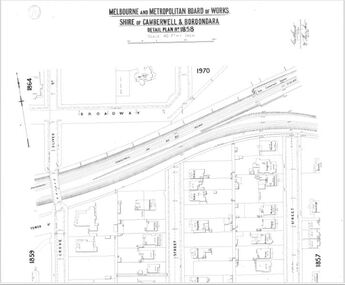 Camberwell Historical Society
Map (Item) - MMBW map, Melbourne and Metropolitan Board of Works, Melbourne and Metropolitan Board of Works - Shire of Boroondara and Camberwell - Detail Plan no. 1858, August 1904
Lithographer E.H.H., Exd J.W.D, Aug 1904, No. 103. 40P.15W.melbourne and metropolitan board of works, map, camberwell, cartography -
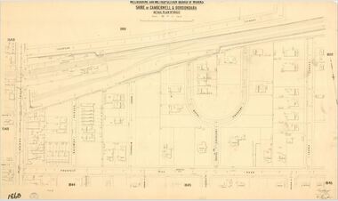 Camberwell Historical Society
Map (Item) - MMBW map, Melbourne and Metropolitan Board of Works, Melbourne and Metropolitan Board of Works - Shire of Boroondara and Camberwell - Detail Plan no. 1860, August 1904
Lithographer E.H.H., Exd J.W.D, June 1904, No. 70. 40P.15W.melbourne and metropolitan board of works, map, camberwell, cartography -
 University of Melbourne, Burnley Campus Archives
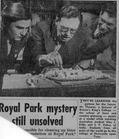
Newspaper - Newspaper Cutting, They Learn to Plan, 1950-1955
J. Kilby (1950) in a photograph with a lecturer at King's College, Newcastle upon Tyne, school of town and country planning.j. kilby, lecturer, king's college, burnley student -
University of Melbourne, Burnley Campus Archives
Newspaper - Newspaper Cutting, The Herald, £100,000 garden plan …Olympic Village, 1954
A rough sketch and text in the "Herald," 10.07.1954 of the proposed plan for the Olympic Village in Heidelberg. Drawn by Erica Ball (1948).the herald, sketch, olympic games 1956, olympic village, erica ball, heidelberg, landscape project olympic village -
Canterbury History Group
Book, Allom Lovell Sanderson Pty Ltd, Conservation Management Plan, Frognall Canterbury Vic. Vol 1
Contains the conservation analysis and broad conservation management plan as well as a description of the physical condition of the buildings for RAAF Frognall.canterbury, mont abert road, frognall, verulan, mountfield, gall> james, towers, stables, staircases, royal australian air force, city of camberwell, elgar's special survey -
Lakes Entrance Historical Society
Book, Dept of Primary Industries Fisheries Publisher, Lake Tyers Fishery Reserve Management Plan, 2007
This management plan is to specify the objectives, stratagies and performance measures for recreational fishing activities within the Lake Tyers ReserveISBN 1448 1693fish, waterways, legislation -
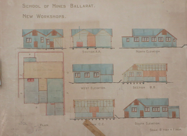 Federation University Historical Collection
Plan, Ballarat School of Mines New Workshops, 1912, 08/1912
Original plan for new workshops for the Ballarat School of Mines. Includes elevations and sections, abd has been coloured with watercolour. The new workshops housed carpenters shop, plumbers, blacksmihing and stores. ballarat school of mines, new workshops, carpentry, blacksmithing, plumbing, architectural plan, laboratory -
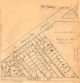 City of Moorabbin Historical Society (Operating the Box Cottage Museum)
Plan - Highlands Estate, Moorabbin
The train line from the city to Frankston was electrified in 1922 which intensified the sale in the municipality of Moorabbin, particularly land which was in the vicinity of the railway stations. This estate was auctioned on Saturday, October 20, 1923.Example of the progress of the Municipality of MoorabbinAdvertising flyer for auction of real estate sales - plan of building blocks for saleHighlands Estate, Moorabbin plan.point nepean road (nepean highway), schofield street, taverner street, herbert street (now linton street), moorabbin, real estate, auction -
 Kew Historical Society Inc
Plan - Subdivision Plan, J R Mathers & McMillan, Myrtle Hill Estate, East Kew, circa 1949, c.1949
The Kew Historical Society's map collection includes a substantial number of real estate subdivision plans, mainly of Kew but also of surrounding suburbs in Melbourne. Most of the subdivision plans date from the 1920s and 1930s when the districts old homes and local farmland were being split up to accommodate residential growth in the postwar period. These early plans were assembled by a local firm, Jas R Mather & McMillan, which had an office in Cotham Road. Many of the plans, and sometimes photos, were annotated by the agents.Subdivision plans are historically important documents used as evidence for the growth of suburbs in Australia. They frequently provide information about when the land was sold as well as evidence relating to surveyors and real estate and financial agents. The numerous subdivision plans in the Kew Historical Society's collection represent working documents, ranging from the initial sketches made in planning a subdivision to printed plans on which auctioneers or agents listed the prices for which individual lots were sold. In a number of cases, the reverse of a subdivision plan in the collection includes a photograph of a house that was also for sale by the agent. These photographs provide significant heritage information relating house design and decoration, fencing and household gardens.The photograph may also be aesthetically significant depending on the importance of the photographic atelier.Myrtle Hill, at 14 Vista Avenue, Kew, is of local historical and architectural significance as a good example of a large and imposing single-storey Italianate house of the early 1870s surviving in Kew. Originally sited on a large allotment overlooking Normanby Road, the setting of the house has been dramatically altered through extensive subdivision and development. The subdivision plan of the ‘Myrtle Hill Estate’ indicates that in one such subdivision, 11 allotments were created fronting Bowyer Avenue, Myrtle Avenue, and Normanby Road. The outline and building profile of Myrtle Hill is shown on the west side of Bowyer Avenue.The full (typed) title of this subdivision plan is :"Plan of SUBDIVISION of part of CROWN PORTION 83. / at KEW / PARISH OF BOROONDARA. / COUNTY OF BOURKE". / "MYRTLE HILL ESTATE / EAST KEW" In addition to the Title and subtitle, the plan also lists the advantages of the subdivision. -
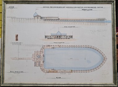 Glenelg Shire Council Cultural Collection
Drawing, ACME, Design for Combined Hot and Cold Seawater and Swimming Baths - Portland, c. 1888
Drawing/plan showing the design for the Portland Seabaths. At the top of the plans is the side elevation titled underneath, below is the front elevation and at the bottom the whole plan from the top. The scale is 16 feet to 1 inch. There is also an image of the Wilson Donkey Pump.Top Left - ACME Design for Combined Hot and Cold Seawater and Swimming Baths / Portland In handwriting to the right of the plan ' Agreed to and adopted by the Council of the Borough of Portland on the 30th May 1888'portland sea baths, seawater baths, acme, design, plan -
Port Melbourne Historical & Preservation Society
Document - Report, Plan of General Development, Mr J Green (Government Printer), Plan of General Development, 1929
Plan of General Development. Melbourne Report of Metropolitan Town Planning Commission, 1929. Was passed on by local history librarian as it was no longer required. On p63 shows view up Swallow Street and contrasts it with approach of St Kilda. P42 aerial view of Port Melbourne piers. Also includes maps and photographs.town planning, piers and wharves, swallow street -
NMIT (Northern Melbourne Institute of TAFE)
Report: Strategy plan 1991 Northern Metropolitan College of TAFE
A4 size bound booklet of 72 pages. Years 1991-1993. Also 59 page Management plan 1991.reports, northern metroplitan college of tafe, nmit -
 Camberwell Historical Society
Map (Item) - MMBW map, Melbourne and Metropolitan Board of Works, Melbourne and Metropolitan Board of Works - Shire of Boroondara and Camberwell - Detail Plan no. 1851, July 1904
Lithographer JEM, exd. JWD, July 1904, no. 81, 40P. 15W.melbourne and metropolitan board of works, map, camberwell, cartography -
Lakes Entrance Historical Society
Book, East Gippsland Shire Council, East Gippsland Shire Fire Prevention Plan June 2003, 2003
Fire Prevention stategy identifying plans to decrease the vulnerability of people and property in the shire with uncontrolled fires East Gippsland Victoriafire brigade, vegetation -
 City of Moorabbin Historical Society (Operating the Box Cottage Museum)
Plan - Scott's Estate, Bentleigh
The train line from the city to Frankston was electrified in 1922 which intensified the sale in the municipality of Moorabbin, particularly land which was in the vicinity of the railway stations.Example of the progress of the Municipality of MoorabbinHand drawn plan of Scott's Estate, BentleighHand drawn plan of Scott's Estate, Bentleighcentre road, scotts street, renown street, lawaon street, wood street, leckie street, bolinda street, bentleigh, real estate -
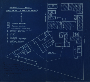 Federation University Historical Collection
Plan, Ballarat School of Mines Proposed Layout
Blueline plans of the present and proposed layout the Ballarat School of Minesballarat school of mines, buildings, plans, grant street, lydiard street south -
Clunes Museum
Document - PLAN, JOHN RUTHERFORD, CLUNES KNITTING AND MANUFACTURING COMPANY
PLAN & GENERAL ARRANGEMENT FOR THE CLUNES KNITTING AND MANUFACTURING CO. LTD. local history, documnts, plans, knitting mill interknit hosiey co. -
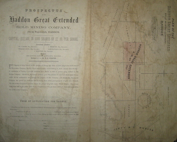 Federation University Historical Collection
Plan and Prospectus, Plan and Prospectus of the Haddon Great Extended Gold Mining Company
The Haddon Great Extended GMC was formed sometime in the 1870s for the purpose of mining 270 acres of land lying to the south-west of the Racecourse Company (who at that stage had a shaft at the depth of 86 feet)A printed piece of paper with a prospectus on the left and a plan on the right. The plan includes a shaded area representing the Haddon Great GMC, and shows neighbouring companies such as Racecourse GMC, Haddon Consols, Reform GMC, Haddon Co, and also shows Russel's Private Propert and Roach's Private Company, and the Trap-Rock Formation.haddon great extended gmc, wc elder, william levey, c thorburn, john langdon, hb forster, national bank of australasia, haddon, racecourse company, h.b. forster, w.c. elder, john langdon, william levey, c. thorburn, john langdon, shares, racecourse goldmining company, reform gold mining company, haddon consols, haddon great extended gold mining company, russell -
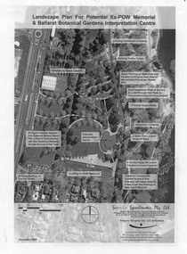 Ballarat Tramway Museum
Document - Photocopy, Gregory Burgess Pty Ltd and Architects and, "Landscape Plan for Potential Ex-POW Memorial & Ballarat Botanical Gardens Interpretation Centre", Nov. 2005
Three page photocopy consultation document titled "Landscape Plan for Potential Ex-POW Memorial & Ballarat Botanical Gardens Interpretation Centre" showing concept plans for the development to the east of the tram depot and for the POW memorial. The project did not proceed. Prepared by Gregory Burgess Pty Ltd, Architects, November 2005.trams, tramways, gardens, depot, botanical gardens -
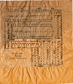
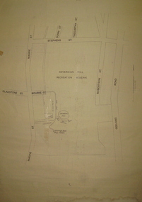 Federation University Historical Collection
Plan, Sovereign Hill Recreation Reserve and Surrounds
This map was probably produced around the time that the Sovereign Hill Museums Association was established. A simple plan with black marking on paper. It shows the Sovereign Hill Recreation Rerserve, including the swimming pool located near the Sovereign Hill Trig Point, showers, toilets, kiosk, bandstand and pine trees. The plan also depicts the Ballarat East streets surrounding Sovereign hill, including Geelong Road, Magpie Street, Stephens Street, Tregurtha Street, Dunn Street, Bourke Street, Gladstone Street and Robertson Street. The scale is 2 chains to 1 inch.sovereign hill, swimming pool -
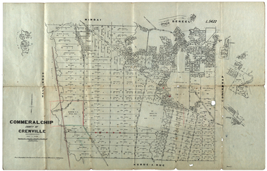 Federation University Historical Collection
Plan, Commeralghip, County of Grenville, 1905, 03/02/1905
The Township of Kaleno is in the Pitfield Plains. The Cape Clear Cemetery T contains the graves of miners and local pioneering families from the Cape Clear, Hollybush, Kaleno, Pitfield Plains, Pitfield, Illabarook, Berringa, Springdallah, Wallinduc, Glenfine, Happy Valley and Western Creek districts.Plan of allotments in Commeralghip, County of Grenville, Victoria. The plan includes the township of Kaleno, Dereel Pre-Emptice Right (John Cullen), Commeralghip Pre-Emptive Right (John Gordon McMillan and Glenfine Pre-Emptive Right (William Rowe). It also includes landholders such as Robert mcPherson, C. Cameron. John Boyd, John Cullen, W.T. Rowe, George Currie, J.P. Mackay, T. McCaffery, G. Hawkins, Alexander McPherson, C. Cameron. Gift of the Squire Family, 2014commeralghip, pitfield plains, kaleno, dereel, glenfine, squire, richard squire, w.t. rowe, john cullen, alexander mcpherson, george currie, mt misery, william rowe, mindai, john gordon mcmillan -
Stawell Historical Society Inc
Archive, Stawell Gold Mine, Stawell Gold Mine Emergency Plan, 1/08/2015
Plans produced by Mine for Emergency use showing ventilation & Emergency Exits Plans and Conatacts.Ring Bound A3 book with laminated Covers & Black and Yellow Banding for attentionDate of Issue 31/ 08/2015 Uncontrolled Copymining, gold