Showing 2399 items matching " structure"
-
 Port Melbourne Historical & Preservation Society
Photograph - Albion Hotel, Evans Street, Port Melbourne, Meredith Turnbull, Dec 1996
Meredith TURNBULL photographed this series in 1996 to record the rapidly changing streetscape, which had already had a number of old houses replaced by concrete two-storey structures under the State government's urban consolidation policyFrom a series of 70 colour photos recording all buildings in Evans Street from Graham Street overpass to Ingles Street, as photographed from the railway reservation, by Meredith TURNBULL in December 1996 - Albion HotelHouse numbers noted on backbuilt environment - commercial, business and traders - hotels, meredith turnbull, albion hotel -
Port Melbourne Historical & Preservation Society
Photograph - 120, 122 & 123 Evans Street, Port Melbourne, Meredith Turnbull, Dec 1996
Meredith Turnbull photographed this series in 1996 to record the rapidly changing streetscape, which had already had a number of old houses replaced by concrete two-storey structures under the State government's urban consolidation policyFrom a series of 70 colour photos recording all buildings in Evans Street from Graham Street overpass to Ingles Street, as photographed from the railway reservation, by Meredith Turnbull in December 1996 - number 120, 122, 123House numbers noted on backbuilt environment - domestic, meredith turnbull -
Port Melbourne Historical & Preservation Society
Photograph - Gloucester House, Evans Street, Port Melbourne, Meredith Turnbull, Dec 1996
Meredith TURNBULL photographed this series in 1996 to record the rapidly changing streetscape, which had already had a number of old houses replaced by concrete two-storey structures under the State government's urban consolidation policyFrom a series of 70 colour photos recording all buildings in Evans Street from Graham Street overpass to Ingles Street, as photographed from the railway reservation, by Meredith TURNBULL in December 1996 - Farrell Street West and Gloucester House (once home of Wm PROHASKY)House numbers noted on backbuilt environment - domestic, meredith turnbull, william henry prohasky -
Port Melbourne Historical & Preservation Society
Photograph - 344 Graham Street, Port Melbourne, Meredith Turnbull, Dec 1996
Meredith Turnbull photographed this series in 1996 to record the rapidly changing streetscape, which had already had a number of old houses replaced by concrete two-storey structures under the State government's urban consolidation policyFrom a series of 70 colour photos recording all buildings in Evans Street from Graham Street overpass to Ingles Street, as photographed from the railway reservation, by Meredith Turnbull in December 1996 - 344 Graham StreetHouse numbers noted on backbuilt environment - domestic, meredith turnbull -
 Hymettus Cottage & Garden Ballarat
Photograph, Ballarat West Railway Station staff
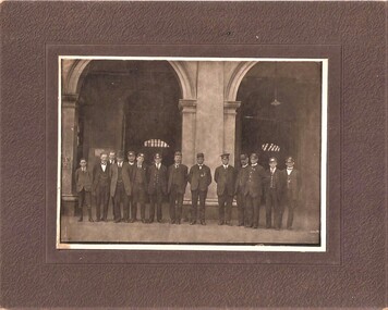
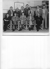
Railway Station staff were an important part of the social structure of both the railway and wider communities in the 1920s. Here Michael Taffe (1) is pictured with other staff members in front of the arches at the Ballarat West Railway Station.On back of mounting board, Mick Taffe, Middle, Head Porter. -
 Hume City Civic Collection
Photograph, late 1970s
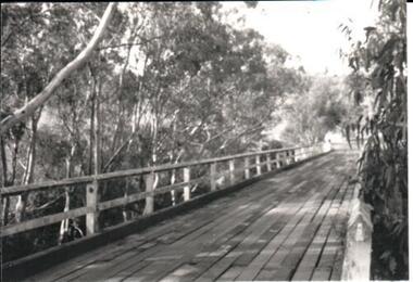
The photograph was taken before the wooden Holden Bridge which spans an arm of the Deep Creek at Bulla was replaced by a more sunstantial concrete structure. As well as building a new bridge, the sharp bend and approach to the old bridge was also removed.A black and white photograph of a wooden road bridge with eucalypt trees growing on either side of the bridge.bridges, holden bridge, shire of bulla, george evans collection -
 National Wool Museum
Photograph
Depicts Bungaree Shed, a big old store structure with the original part being commenced in 1842. View of buildings from north-west. Taken by John Bailey in South Australia at the request of Gael Shannon (former NWM employee). -
 National Wool Museum
Photograph
Depicts Bungaree Shed, a big old store structure with the original part being commenced in 1842. View of buildings from north/west. Taken by John Bailey in South Australia at the request of Gael Shannon (former NWM employee). -
 Halls Gap & Grampians Historical Society
Photograph - Photocopy, C 1930s
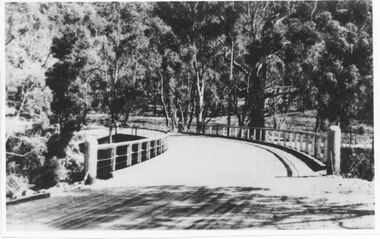
The third Delley's Bridge, a timber and concrete structure with a curved deck, built in 1940. It was situated slightly upstream from the previous bridge. After nearly 50 years of its use, wear and tear necessitated a fourth bridge to be erected in 2001.The picture shows a curving bridge with a wood and wire railing. An unsurfaced road crosses the bridge and the area is surrounded by trees.structures, tents -
 Eltham District Historical Society Inc
Photograph, Main Road Bridge, Eltham, c.1924
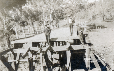
The wooden Main Road Bridge was substantially damaged in the 1924 flood and was replaced with a concrete structure Pages from a scrapbook belonging to Heather Jenkins (nee Sargeant) who lived as a child in the Police Residence at 728 Main Road, Eltham in the 1920s.This photo shows the flood damage to the bridge structure or the dismantling of the bridge post 1924 flood. Heather Sargeant was the daughter of Constable W.C. Sargeant, the local police officer in residence at Eltham, 1922-1927Glued on a brown paper scrapbook page (torn from scrapbook) with 9 black and white/sepia photos of varying sizes, 1 newspaper clipping and handwritten captions in ink.On verso in pencil "Const. W.C. Sargeant 1922-1927 - see Police list"heather jenkins (nee sargeant), eltham, police residence, constable w.c. sargeant, main road, main road bridge -
 Uniting Church Archives - Synod of Victoria
Photograph, Charles Harris, 10/1984
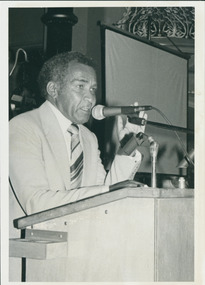
The photo is reproduced in C&N along with the report from the 1984 Victorian Synod meeting. Harris is not mentioned personally, but there is a two paragraph statement saying that the Synod overwhelmingly endorsed the proposed mandate and structure for the Uniting Aboriginal & Islander Christian Congress.Standing at a lectern speaking, dressed in a suit."Charles Harris, Charismatic & fervour & liberation theology."harris, charles, aboriginal and islander christian congress -
 Hume City Civic Collection
Photograph, late 1990s
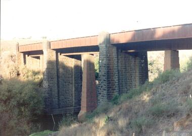
The bridge constructed from bluestone, brick and iron over the Jacksons Creek at Sunbury is an important structure on the Melbourne-Echuca rail line. The foundation stone for the bridge was laid on 13 January 1859 and the bridge opened in July 1861. It is of state significance.A coloured photograph of the bluestone and iron railway bridge which is ove the Jacksons Creek. The bridge has 3 bluestone pylons and three iron pylons with 3 sections of the iron spans visible across the top.transport, bridges, rail transport, darbyshire, g. c., jacksons creek, george evans collection -
 National Wool Museum
Photograph
Depicts Bungaree Shed, a big old store structure with the original part being commenced in 1842. Shows the pens with fencing - particularly vertical slats. Taken by John Bailey in South Australia at the request of Gael Shannon (former NWM employee). -
 Sunbury Family History and Heritage Society Inc.
Photograph
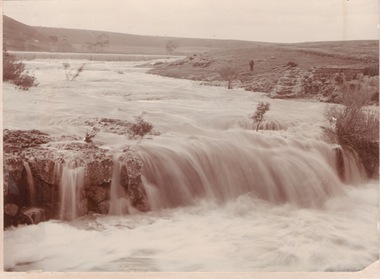
The waterfalls were on the Jacksons Creek downstream from Sunbury township and in the vicinity of a mill which was built on the river bank. The man standing on the riverbank on the RHS of the image is near the remains of Eadie's Mill which was one of the early structures erected in Sunbury.A sepia photograph mounted on a cream board of two waterfalls in a flooded river with bare hills on either side. A man is standing near some stone ruins on the RHS of the image.waterfalls, jacksons creek, mill falls -
 Vision Australia
Administrative record - Text, RPH minute book, 1979-1983
Minutes relating to the formation and running of the Radio for the Print Handicapped Co-operative Limited directors meetings. The agenda included attendees, reports, financial statements and correspondence, and covered areas of establishing a structure, programming, technical needs, resourcing and the running of the station. 2 volumes of typed minutes glued to pagesassociation for the blind, 3rph -
 Port of Echuca
Black and white photograph, Approx.1980
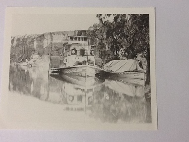
Details of P. S. Queen: construction: composite 16 h.p. Registered tonnage: gross 128, net 92. Dimensions:L.103.3 ft B.18.5ft. D 5.7ft. Port and date of registry:Adelaide, 1880, no.43, 154. Built at Goolwa, S.A., 1865!. Owner: Chas Oliver. Lengthened in 1872. Details of barge Bourke. Construction:wood. Tonnage: 124. Dimensions:L 108.5 ft X B 20.5 ft X D 8.0 ft. Port and date of registry:Adelaide, 1898, no. 74, 771. built at: Miland, S. A. 1876. Owner: A. L. Land seer. Information from "The register of Australian & N. Z. Shipping 1898. This photograph has historical and social significance being typical of transport on the rivers systems of Australia in the late 1800s. Paddlesteamers carried supples to settlers and then carried their produce such as Wool and other produce down the rivers to markets or to be transferred by rail to the major ports such as Melbourne or Adelaide. Black and white photograph of P. S. Queen with the barge Bourke rigged to its side. Photographed in a gorge where boats appear to be moored. Photograph taken from the bow of the Queen with 3 people visible on the port side of the boat and there appear to be sacks stacked on the front of the boat. The barge Bourke has a tent structured tarp over it. Copy of an original photograph (date unknown)Inscription in pencil on reverse:Queen. On the photograph can be seen "Queen" on the bow and partically on the wheelhouse. The barge has "Bourke" visible on its bow.p. s. queen, bourke barge, paddle steamers -
 Bendigo Historical Society Inc.
Newspaper - JENNY FOLEY COLLECTION: NURSES' QUARTERS
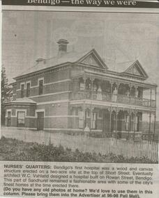
Bendigo Advertiser ''The way we were'' from 2000. Nurses' quarters: Bendigo's first hospital was a wood and canvas structure erected on a two-acre site at the top of Short Street. Eventually architect W.C. Vahland designed a hospital built on Rowan Street, Bendigo. This part of Sandhurst remained a fashionable area with some of the city's finest homes at the time erected there. The clip is in a folder.newspaper, bendigo advertiser, the way we were -
Bendigo Historical Society Inc.
Map - MAP: VIRGINIA MINE GARDEN GULLY LINE OF REEF
Map of Virginia Mine on the Garden Gully line of reef, Eaglehawk, transverse section. Shaft, levels and Garden Gully anticlinal axial line drawn. Key shows types of formations - quartz, spurs, sandstone, slate, cleavage, lava. This map forms part of the Geological Survey of Victoria, Structure of Bendigo Goldfield report, No. 47, 1923. H.Herman, late Director of Geological Survey.Geological Survey Victoria, Geological Survey Office, Bendigo.bendigo, gold mining, virgina mine eaglehawk, eaglehawk, bendigo, gold mining, virginia mine, garden gully line of reef. -
 Bendigo Historical Society Inc.
Document - BILL ASHMAN COLLECTION: CORRESPONDENCE
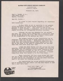
Five copies of a letter from ? Smith, Engineer Way & Structures, of the Kansas City Public Service Company to Paul A. Douden & Co., dated November 15, 1937. He tells of their experiences with Scalebuoys. He mentions reduction of scale and about a 30% reduction in the consumption of soap and the chemicals used in the water for cleaning purposes. In the bottom left corner is a small picture of a bus and a tram.sciences, instruments - general, scalebuoy, bill ashman collection - correspondence, kansas city public service company, paul a douden & co, ? smith -
 National Vietnam Veterans Museum (NVVM)
Document - Civil Affairs Unit speech 1967, Vietnam
Folder containing what appears to be an original typed text with hand-written notes and a copy of typed final text with the heading, "Vietnam". Seems to be the text of a speech given about the role of the civil Affairs Unit in Vietnam. Also a handwritten letter from L.K. Mackay dated 17 April 1969. Includes a chart of the structure of "The new government of Vietnam" dated November 1967vietnam - history, civil affairs unit, vietnam government, "revolutionary development" -
 Hume City Civic Collection
Photograph
Rosenthal Winery in Vineyard Road, Sunbury was one of the first wineries established in the area. It was owned by R. F. Kurrle. The roofless building still stands on the property which was part of the dairy farm owned by Tom and Angela Millett. The last vintage from the property was crushed in 1910.A coloured photograph of shell of the interior of the Rosenthal Winery. The bluestone is exposed on the lower half of the walls but the walls on the upper storey have either been rendered or painted. Part of the interior wooden structure is still standing. There is an open doorway on the LHS with two windows above it. Two smaller windows are on the lower part of another wall with a larger window above them. The building is roofless.rosenthal winery, wineries, vineyards, vineyard road, sunbury wineries, kurrle, r. f., millett, tom, angela, sunbury, george evans collection -
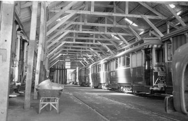 Ballarat Tramway Museum
Photograph - Black & White Photograph/s, Ron Hann, Jan. 1963
Yields information about the interior arrangements of the depot while the tramway is operating. Also shows the way the sand was distributed to the tramcars.Black and white print on heavy matt photographic paper of the interior of Wendouree Parade depot with a number of trams on No. 1 and 3 roads. Shows the structure of the tram depot. Has a wheelbarrow full of sand and a bucket to one side of the photograph and the front end of the tower truck. Source of photo - same as Reg item 3841 - Ron Hann, note added 2/2010.On rear in pencil "Ballarat Depot 1963"tramways, trams, depot, sec depot -
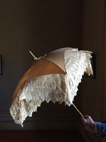 Kew Historical Society Inc
Accessory - Cream Silk & Lace Parasol, c. 1900
Joseph Butterworth COOMBS (1842-1901), was an accountant who founded a successful mercantile trading company. At the time of his marriage to Caroline Mary MICHEL in 1869, Coombs had already purchased ten acres of Studley Park. The acreage included land on the west of Fenwick Street that extended along lower Stawell Street to the corner of Yarra Street, all of it connected directly to the Yarra environs. A right of way to Studley Park Road was on the title, though Coombs went on to purchase more land, some of which faced Studley Park Road. In addition to owning the Studley Park acreage, Coombs later acquired 1,201 acres of land abutting the Acheron River. While retaining the Kew property he became a Taggerty Councillor and was Shire President for a time. J.B. Coombs died at Acheron Station in 1901 (aged 59 years). A few months after, tenders were called to repair the Kew dwelling, the Fenwick Street property now appearing in records with the name ‘Hope Mansell’. Caroline Coombs remained at Hope Mansell until she died in 1924, survived by three sons and five daughters. Not long after her death, advertisements appeared for the sale of the Studley Park land. The sale seems to have been a mechanism for distribution of the Estate, as the following year the original ten acre holding was transferred to members of the family. The eldest daughter Mabel married William Younger who, with his brother Alexander, developed Younger and Mackie Courts, both south of Studley Park Road. [Research: Kerry Fairbank]In 1961, the granddaughter of Joseph and Caroline Coombs, Mabel Isola (Younger) Grattan, donated ten 19th century dresses and parasols to the Kew Historical Society. The costumes, now known as the 'Coombs Collection', are the earliest recorded items of clothing to enter the Society's collection. Each of the items in the Coombs Collection, of which this item forms a part, is historically, aesthetically and socially significant. As a collection, the costumes includes outstanding examples of morning wear, day dresses, wedding dresses, and clothing accessories, providing evidence of outstanding dressmaker skills in Victoria during the mid to late Victorian period. One of a pair of cream silk parasols, each bordered by overlapping bands of beige lace. The underlying structure and mechanism includes a bent cane handle and black metal expanding spokes. The lace borders are layered to create an overlapping fringe. The high-domed umbrellas may have been created for a bridal party. This umbrella cannot be opened due to the silk being shattered."Coombs Collection"coombs collection, clothing accessories, parasols -
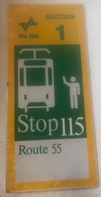 Melbourne Tram Museum
Sign - "Stop 115, Route 55"
Indicated or provided a location to tram drivers and passengers of a tram stop that trams had to be hailed or be requested to stop. Gives details of the fare section. Produced by The Met, possibly during the 1980's. Stop 115 on route 55 (changed to route 58 in May 2017) is in Queensbridge St at the Southbank/Casino tram stop.Demonstrates the form of tram stop that The Met used to replace former tram stop signs and shows the typical tram stop sign of the era. These have since been replaced with Yarra Trams badged signs.Sign - "Stop 115, Route 55", aluminum folded sheet overlain on both sides with a printed reflective sheet with the image of a person hailing or signalling or requesting a tram to stop. Formed with a short angle on one side drilled with three holes for attaching to a pole. Has two holes along the top edge where it was secured to a stop structure. Has The Met logotram stop, signs, the met, route 55, queensbridge st, trams, tramways -
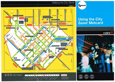 Melbourne Tram Museum
Pamphlet, Metlink, "Using the City Saver Metcard", 2004
Pamphlet - DL size, three fold full colour printed on gloss paper titled "Using the City Saver Metcard", giving details of the card, availability on both train, bus and tram, a map showing the area and major locations within the ticket area. Also has details of how they could be purchased. Printed by Metlink. Has a reference to the fare structure of 2004.trams, tramways, metcard, metlink, city saver, tickets -
 Kiewa Valley Historical Society
Photos - 1. Mt Beauty R.S.L. Committee 1949-1950 2.ANZAC service at Mt Beauty cearly 1950s
R.S.L. is the Returned and Services League of Australia, a member based charity founded in 1916, and the largest veterans' charity in Australia. It provides a support network and community for veterans and their families. They have a commemorative service each year on 25th April, ANZAC Day.The Mt Beauty RSL committee members in 1949 is a list of people living in Mt Beauty at the time and who were working as a support team for veterans and their families. The ANZAC crowd at the temporary memorial indicate the interest in the town for a commemoration and the need for a more permanent structure.Both Black & White large photos. 1. Group of men - Mt Beauty R.S.L. Committee with names on reverse. 2. Anzac Day at Mt Beauty. Early 1950s. People including school children, gathered around a temporary war memorial structure near the current (2023) roundabout. In the background is the main workshop. The Tail race channel hasn't been constructed. On the back in pen of RSL photo: Mt Beauty R S L Committee 1949 -50 / Standing Fred De Little, Roy Cobby, WaJ. Jones/ Joe Lang, Ian Bennett, Stan Leanard, Ted White/ Seated / Harry Edney, Jack Chapman (Tres), Harold Boon (Pres), R Webster (Sec), /Joe Breen returned services league, anzac day, rsl 1949 -
 Bendigo Historical Society Inc.
Slide - DIGGERS & MINING. THE GOLD ERA, c1855
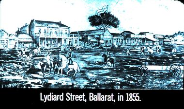
BHS CollectionDiggers & mining. The gold era. Lydiard Street, Ballarat, in 1855. Buildings appear to be wooden structures. The road is not formed but is busy with a couple of wagons, most of the users are men on horseback, one man in the foreground appears to be wealthy as his clothes are upper class. The person on the left on a black horse appears to be a woman. Markings 50 994.031 GOL:5. Used as a teaching aid.hanimounteducation, tertiary, goldfields -
 Bendigo Historical Society Inc.
Newspaper - JENNY FOLEY COLLECTION: AS IT WAS, AND AS IT WILL BE
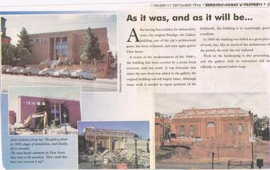
Newspaper article from Friday, September 11, 1998. '' As it was, and as it will be.'' After having been hidden for almost forty years, the original Bendigo Art Gallery building has been reclaimed. A victim of the modernisation of the 1960s the building has been covered by a cream brick structure until last week. Four photos accompanied the article showing the before and after. The clip is in a plastic folder.newspaper, bendigo -
 Eltham District Historical Society Inc
Photograph, Cr. Peter Graham, Eltham Library construction, Oct. 1993
Central roof dome as seen from Main Road, Roof structures being fitted over the main hall, Eltham Library construction, Oct 1993 Construction of the new Eltham Library 1993-1994. Officially opened 22 May 1994. Colour photograph print on Agfa photographic paper 10 x 15 cmconstruction, eltham library -
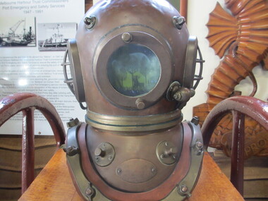 Seaworks Maritime Museum
Divers helmet
Standard dress diving equipment used by Melbourne Harbour Trust from late 1800s until 1991. Because of its structure of heavy canvas, lead and brass, it was used in wharf construction and salvage. Total weight on wearer is approximately 90 kgslarge brass diving helmet