Showing 765 items matching " view point"
-
 Melbourne Tram Museum
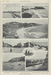
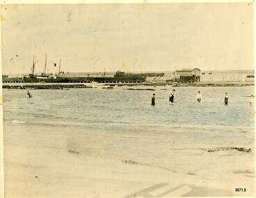
Photograph - Digital Image, Herald and Weekly Times, "Sorrento: A favourite holiday resort", Dec. 1910
Image of page 33 of the 17 Dec 1910 issue of The Weekly Times with a photo page titled "Sorrento: A favourite holiday resort", featuring: 1 - Arrival of the Excursionists - photo shows the pier and a steamer with people walking to the tram 2 - Rocks on the coast 3 - The back beach from Point Coppin 4 - A glimpse of the business portion of Sorrento 5 - Tram terminus back beach 6 - A study (yacht) outward bound 7 - Point Coppin from the back beach 8 - View looking toward front beach from Amphitheatre road. see http://nla.gov.au/nla.news-article222543442Yields information about the Sorrento steam trams and Sorrento itself.Digital image from a newspapertramways, sorrento, steam trams, tourist trips -
 Melbourne Tram Museum
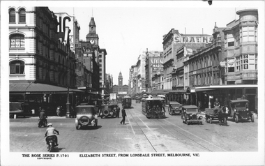
Postcard, Rose Stereograph Co, "Elizabeth Street from Lonsdale Street Melbourne", c1934
... . There is a policeman on point duty. In the view are signs for G A Grano Mantle.... There is a policeman on point duty. In the view are signs for G A Grano Mantle ...Rose Series postcard No. P 1701 titled "Elizabeth Street from Lonsdale Street Melbourne". Has a number of cable trams in the view, the closest one being a Brunswick tram. There is a policeman on point duty. In the view are signs for G A Grano Mantle manufacturers, Smiths Pawnbroker, State Savings Bank, MIchaels Camera store, one horse-drawn cart, and motor vehicles. On the west side footpath under an awning is a "Keep to the left" for pedestrians. Flinders St Railway Station can be seen in the far distance. The Brunswick cable tram line was closed Sept. 1935.Yields information about Elizabeth St, c1930Postcard - printed real photograph with Rose Stereograph Co. name on the rear.On rear in pencil "KM-M-076" and a Ken Magor stamp.trams, tramways, flinders st station, cable trams, elizabeth st -
 Ballarat Heritage Services
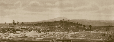
Photograph - Image - Black and White, Ballarat 1853-54, c1904
Black and white panoramic view of Ballarat as it was in 1853-1854. A large circus tent is a focal point. .ballarat, tents, circus tent, goldfield -
 Lakes Entrance Historical Society
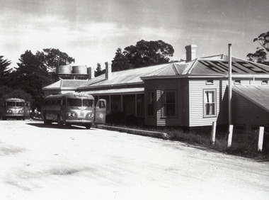
Photograph - Kalimna Hotel, 1960c
This is the before paired photograph used in the 150 year, Lakes Entrance 1858-2008 display.|The after paired photograph number is 01335.1|Also one 12 x 16 framed photograph used in room display.| The hotel was owned by Ansett and used by their coaches for a meal stop-off point. The Kalimna is often referred to as the Hotel with a View.Black and white enlarged photograph showing original Kalimna Hotel prior to a fire in 1962 which burnt the old bar on the Eastern end of the hotel. Dirt road at front with two Ansett buses and people in front of hotel. Two water tanks, three chimneys and hotel painted on top of roof. Lakes Entrance Victoria,restaurant, hotels, room display -
 Ringwood and District Historical Society
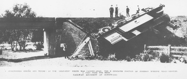
Photograph, Ringwood derailment on 11 Feb 1908 at Wantirna Rd. underpass looking north. Maroondah Highway near trees beyond underpass
Black and white photographs - 2 copiesPrinted directly below photographs, "1. overturned engine and tender at the 'dead end' which was carried away. The X indicates position of fireman McKeone when rescued. 2. View from the road. Railway accident at Ringwood". Typed below photograph, "Ringwood derailment 1902 at Wantirna Rd. underpass looking north. Maroondah Highway near trees beyond underpass". Date incorrect, should be 11 Feb 1908 (as per item 2019) - refer to The Argus article published on Wednesday 12 February 1908, page 7. Thanks to railway enthusiast Neal Glover for pointing out the error. -
 Linton and District Historical Society Inc
Photograph, Taylors Super Snaps Ballarat, Sussex Street, Linton
Photograph taken from high vantage point further along Sussex Street. Visible east side: Edinburgh Bakery, Preston's shop, Wishart's blacksmiths. Church of England vicarage in the distance. Visible west side: roofs of Morgan's and Sandow's stores. The photograph is undated but thought to have been taken in the 1940s, as there are electricity poles in the street. (Electricity came to Linton in 1939).Very small photograph of Sussex Stret, Linton, view to south-east.sussex street linton -
 Lakes Entrance Historical Society
Postcard - SS Wyrallah, SS Manawatu, c1910
Sepia toned postcard showing view of New Works buildings at north end of eastern pier. Cunninghame Arm in front of buildings, Reeves River left in distance. SS Wyrallah steaming past, and SS Manawatu at pier. Jemmy's Point, Mt Barkly, and Kalimna hills in background. Photo taken from top of dune. Smoke issuing from SS Wyrallah funnel. Carstairs boarding house in centre foreground. Lakes Entrance VictoriaLakes Entrance - Gippsland Lakes ships and shipping, piers, historic site -
 Lakes Entrance Historical Society
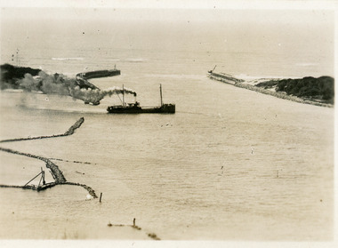
Postcard - SS Despatch, c1910
Second copy same viewSmall format postcard showing coastal steamer SS Despatch leaving Cunninghame Arm, with entrance piers and rock groynes in view. Lakes Entrance VictoriaThe Piers from the lookout at Jemmys Point (on back)jetties, topography, ships and shipping -
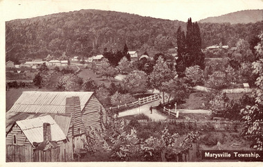 Marysville & District Historical Society
Postcard (item) - Black and white postcard, Marysville Township, 1936
A digital copy of a black and white postcard of the view of the Marysville township taken from the Steavenson Hotel.A digital copy of a black and white postcard of the view of the Marysville township taken from the Steavenson Hotel.marysville, victoria, australia, steavenson hotel, poontawan, marysville chalet, george wright, pack road, wood's point road, wood's point mountaineer, albion restaurant, steavenson's creek, yarra track, bridge inn, butler's woods point general directory 1866, postcard -
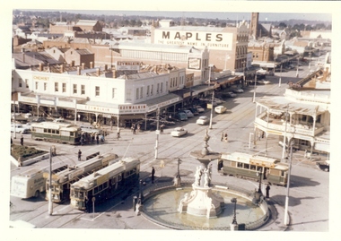 Bendigo Historical Society Inc.
Photograph - BASIL MILLER COLLECTION: TRAMS AT ALEXANDRA FOUNTAIN, BENDIGO, 1960's
BHS CollectionColour photo of 4 trams taken at Alexandra Fountain, Bendigo. Two trams entering from View Street, one tram entering from Pall Mall, another entering intersection from High Street. Possibly photo was taken from high vantage point - City Family Hotel. "Maples" and 'Ezywalkin' advertising signs on Mitchell Street buildings. basil miller, bendigo tramways, charing cross, alexandra fountain, mitchell street, high street -
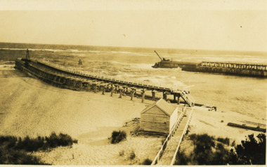 Lakes Entrance Historical Society
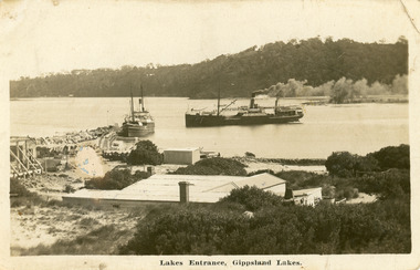
Photograph - The Entrance Lakes Entrance, 1920 c
Also two other black and white photographs taken at same time , one of the ocean end of western pier and one of eastern pier taken looking towards Kalimna and Jemmys Point 05294.1 and 05294.2Black and white photograph of view of the entrance to Gippsland Lakes showing east and west piers and kiosk building next to boardwalk to eastern pier Lakes Entrance Victoriawaterways, piers -
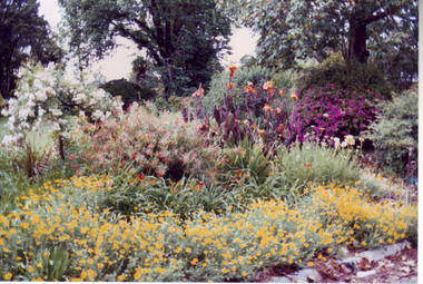 University of Melbourne, Burnley Campus Archives
Album - Colour prints, Stuart Miller, Garden Views, 1983
Colour photographs. (1) Herbaceous Border 1984-5 (pre-Rainforest) #277. (2) View Admin Building from between Emily Gibson Beds. (3) Admin Building. (4) View of Bull Paddock, Dairy and beyond from roof of Admin Building. (5) Rear of Burnley. Tennis Court replaced by PSL 4-6 (DA) (6) Shady Walk Mondograss (Ophiopogon japonicus) Umbrella Grass (Cyperus alternifolius) (David Aldous). (7) Admin Building and Student Amenities Building. (8-10) Luffmann Ponds. (11) Frank's/Rock Point. (12-13) Oak Lawn. (14) Oak Tree lawn on reverse "Please return to Stuart Miller, Burnley College." (15) E. cladocalyx. (16) The Victorian College of Agriculture & Horticulture-Burnley Campus. U. procera to the left E. cladocalyx to the right DA. (17) Sugar Gum E. cladocalyx Burnley Gardens 1989 DA. (18) Burnley College in background DA Crack Willow in winter. (19) Tree unidentified. DA (20) DA View of trees behind Luffmann Ponds. (21) View of Burnley Gardens Pinus canariensis to the left Agathis robusta centre and sequoia sempervirens to the right DA. (22) Students in Citriodora Courtyard. (23) View of Emily Gibson Beds from roof of Admin Building. (24) Admin Building from Oak lawn. Annotated by David Aldous and Stuart Miller. herbaceous border, administration building, emily gibson beds, bull paddock, dairy, tennis court, shady walk, luffmann ponds, oak lawn, david aldous, stuart miller, student amenities building, sugar gum, citriodora courtyard, lily ponds -
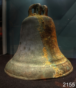 Flagstaff Hill Maritime Museum and Village
Ceremonial object - Church Bell, Before 1855
This artifact is a large brass bell. It was retrieved from the Schomberg wreck by local divers in the 1970s. Its location at the wreck site was described as "found on the west side towards the stern" the vessel remains lying on a north-south axis, with the bow pointing towards the shore as a result the bell was assessed from this position to have formed part of the cargo. The view that this was not a ship's bell belonging to the Schomberg is gained from two other 'Schomberg Bells' in the Flagstaff Hill collection, both of which have the vessel's name prominently etched into their outer surface. Additional indications indicate that this bell was not intended for maritime use due to the bell's rounded 'bell-curve' shape suggesting it was melodically tunable. Also the detailed basket-type fittings on the bell dome that would allow the bell to be suspended by ropes rather than just bolted to a yoke. The bell is currently on display at Flagstaff Hill, categorised as a church bell part of the Schomberg's cargo that was intended for use in a church within the Victorian colony. As the Colony of Victoria became more established, and its population expanded with the Gold Rush and other emigration from Britain, the demand for regular religious services and permanent church buildings also grew. We will never know if this bell was a specific order or part of an enterprising bell founder's consignment of general stock to a wholesale supplier in Melbourne. A cargo manifest for the Schomberg has unfortunately never been found. The shipwreck of the Schomberg is regarded as of significance to Victoria and is registered on the states Heritage list (S 612). The Schomberg wreck has great historical significance as a rare example of a mid 19th century large, fast clipper ship intended to transport cargo and passengers between England and Australia. The vessel that carried this bell represents the marine advances made in an attempt to break established sailing records between Europe and Australia. Flagstaff Hill holds a noteworthy collection of artefacts from the Schomberg shipwreck. The collection as a whole is primarily significant because of the relationship the objects have archaeologically, not only to highlight the story of the Schomberg ship and later it's wrecking but have an important potential to interpret the story and progression of maritime shipping in the 19th century. The church bell has a standard bell-curve shape and is dull bronze in colour. A large brass bell, plain and without visible maker marks, but with traditionally intricate basket-type cast fittings for suspension from a yoke by a number of ropes or chains. Approximately 3/8 of the bell’s outer surface bears a thin layer of marine growth and limestone accretion, and there is some minor pitting and spots of light verdigris over the remainder. The bell mouth, or lip, is slightly compressed-in in two places. It was retrieved from the wreck of the Schomberg. warrnambool, flagstaff-hill, flagstaff-hill-maritime-museum, maritime-museum, shipwreck-coast, flagstaff-hill-maritime-village, schomberg, shipwrecked-artefact, clipper ship, black ball line, 1855 shipwreck, aberdeen clipper ship, captain forbes, peterborough shipwreck, ss queen, brass bell, church bell -
 Chelsea & District Historical Society Inc
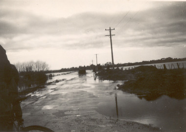
Photograph - Chelsea Flood December 1934, Wells Road, Chelsea
In December 1934, 700 houses were inundated with water, when the Dandenong Creek and Patterson River broke their banks.Three Black and white photo of flood waters across Wells Road, Chelsea. A SEC truck can be see travelling down Wells Road in photo one and two, with people viewing the flooded street.flood, chelsea, dandenong creek, nepean highway, point nepean road -
 Lakes Entrance Historical Society
Postcard - The Entrance at Lakes Entrance, Murray Studios Gympy Qld, 1930 c
Also a second hand colourewd postcard of similar view showing navigation light on right side of photo 05366.1 6.5 x 10 cmColoured postcard showing view of houses at the entrance and New Works buildings and western end of Bullock Island and rock groynes. Post and rail fence on Jemmys Point Lakes Entrance VictoriaMurray views No 32 A picture view of the Entrance at Lakes Entrancewaterways, islands -
 Lakes Entrance Historical Society
Album, Festivals in Lakes Entrance
An Album of Clearwater Festival, Larger Than Lakes Festival, Festival of the Lakes Festival, Plaque Dedication Jemmy's Point. Please visit the Lakes Entrance History Center to view all photos fest, events -
 Flagstaff Hill Maritime Museum and Village
Photograph - Vessel S. S. Casino in Lady Bay Warrnambool, 1920's - 1930's
This photograph was one of ten photographs donated to Flagstaff Hill Maritime Museum and Village by Fred Trewartha. Frederick John Fox Trewartha (Fred) was a well-known Warrnambool businessman. He was born in Beeac near Geelong in 1920 and came to Warrnambool with his family as a very young child. He was apprenticed to his father John, as a saddler and later opened his own shop on Raglan Parade. He then moved into working with tarpaulins and canvases for the trucking industry. Fred was keenly interested in photography (and was a member of the Warrnambool Cine Club), yachting and boat building. He kept his yacht moored at Port Fairy for many years and participated in sailing events locally and interstate. He also built boats with his sons. He had the opportunity to meet many older sailors and it's thought this photo (and others in the set) may have been given to him by one of these men. Fred Trewartha died in 2016 in Warrnambool. Warrnambool by the 1920's and 1930's had become a popular holiday destination with visitors arriving by steamer and train. It was during these decades that a "Surf Bathers Association" began in Warrnambool in response to the growing popularity of local sea bathing. They worked with the local council to develop a "Beach Improvement Fund" and a comprehensive plan of "Beach Improvement" which included erecting and maintaining beach boxes, building a kiosk, improving paths and roads to the beach, planting marram grass on the sand dunes, building new enclosures for vehicles and horses and generally making the beach more attractive for visitors and townspeople. The 1930's was also an era when free "Herald" Learn-to-Swim classes were being held throughout Victoria. In 1931 it was reported in "The Age" newspaper that "over the past week in Warrnambool, 250 pupils had passed through the hands of the local life saving club swimming instructors". The Port of Warrnambool - In the early years the Port of Warrnambool was a busy port. Steamships and sailing ships were frequent visitors to the port. Steam navigation companies were plentiful, carrying passengers and freighting cargo such as coal, timber, food, livestock, furniture, hardware and haberdashery between Melbourne and the ports along the southwest coast of Victoria, including Warrnambool. The carts would take their loads into the township for distribution. The Breakwater was built (using 32 ton blocks of concrete) between 1874 and 1890 to provide ships with greater protection from the Southern Ocean. The Lifeboat and Rocket House - The coastline of South West Victoria has had over 600 shipwrecks and many lost lives; even in Warrnambool’s Lady Bay there were around 16 known shipwrecks between 1850 and 1905, with eight lives lost. In 1859 the first Government-built lifeboat arrived at Warrnambool Harbour and a shed was soon built to house it, followed in 1864 by a rocket house to safely store the Rocket Rescue equipment. In 1878 the buildings were moved to the Breakwater area, and in 1910 the new Lifeboat Warrnambool arrived with its ‘self-righting’ design. For almost one hundred years the lifeboat and rocket crews, mostly local volunteers, trained regularly to maintain and improve their skills, summoned when needed by alarms, gunshots, ringing bells and foghorns. Some became local heroes but all served an important role. By the end of the 1950s the lifeboat and rescue equipment had become obsolete. The S.S. Casino was a passenger and freight steamer built in Dundee, Scotland, in 1882 for the Newcastle and Hunter River Steam Navigation Company of N.S.W. She weighed 425 tons gross with a length of 160.4 feet, beam of 24.1 feet and a depth of 10.2 feet. She had saloon accommodation for 35 people, a fore cabin for 25 more people, and she carried 300 tons of cargo. While on her delivery journey on May 30th 1882, the S.S. Casino called in at the Port of Warrnambool for coal, narrowly escaping going ashore in gale force winds due to the quick action of the pilot. At that time, still at anchor, she impressed the directors of the Belfast and Koroit Steam Navigation Company so much that they bought her immediately; she was ideal for trade along the West Coast of Victoria. (The Belfast and Koroit Steam Navigation Company was first managed by Messers. Saltau and Osburne and after the passing of Mr. Osburne, by produce merchants Messers H. Sautau and Sons, who had a hay and corn store and shipping agency on the corner of Liebig and Koroit Streets in Warrnambool. ) The S.S. Casino became “the most famous steamer to operate in Victorian waters along the West Coast” by author Jack Loney. Captain Boyd was her first Master, followed by Captain Chapman, who stayed with her from 1890 until 1924. Captain W. Robertson followed for a short term, and then Captain Middleton then took command from 1925 - 1932. An article published on Monday 11th June 1932 in The Sun News Pictorial (Melbourne) giving a detailed history of S. S. Casino said "owned by Port Fairy interests, she was an integral part of the town's development ... for a long time, her arrival in Port Fairy was an event, the townspeople going down to the wharf to see her come in". It also said "Except when the weather was bad, the Casino hugged the coast on her trips and passengers obtained wonderful views of the sandstone terraces and caves. A little time ago every member of her regular crew except one, was a Scotsman." The S.S. Casino had several mishaps during her life. One was on 3rd January 1898 when she collided with the S.S. Flinders in Apollo Bay with minor damage. Another was on 24th October 1924 when she grounded on a reef at Point Hawdon near Grey River and most of her cargo (of Christmas goods) had to be dumped into the sea. Then in February 1929 she was ‘holed’ when she struck a submerged object as she entered Lady Bay, Warrnambool. In the years following the turn of the century, the S.S. Casino remained the only regular trader with normal passenger accommodation along the West Coast. From 1882 she had made at least 2,500 voyages on the one run. On the morning of 10th July 1932, after attempting to berth at Apollo Bay jetty in heavy seas, Captain Middleton decided to take her out into the bay and wait until the seas abated. It was not realised that the anchor used to steady her as she manoeuvred to her berth had pierced her hull. She put about and headed for the beach but sank. Captain Middleton and nine others lost their lives; nine people were rescued including the two female passengers. Captain Middleton had been in charge of the S.S. Casino for seven years. He was the first ship’s Master to lose his life in a shipwreck in the West Coast trade. In June 1932, the directors of the Belfast and Koroit Steam Navigation Company had proposed to celebrate the completion of fifty years of trading by the steamer Casino in August, but tragically the Casino was wrecked only one month later (and "was only one month off completing its fifty years of valuable service between Melbourne and Portland.") Flagstaff Hill’s collection has a photograph of a portrait of Captain Chapman, a ship model of the S.S. Casino that shows both forms of power under which she sailed, steam and sail. The ship is painted green and flies three flags. The inscription across the case of the ship model, incorrectly dated, tells the sad story of the wreck of the ship and the loss of lives on July 10th 1932 at Apollo Bay. A print in the Collection shows S.S. Casino underway in the heavy sea off Point Lonsdale, another two photographs show her at the Port of Warrnambool, leaving from the Breakwater in Lady Bay and another identifies the S.S. Casino as a ship from the Belfast and Koroit Steam Navigation Company. (Belfast is the original name for the township of Port Fairy).This photograph is significant because of its association with the coastal trader S.S. Casino and its significance to trade along Victoria's West Coast in the late 19th and early 20th centuries. The wreck of the S.S. Casino is considered an important part of Victorian and Australian cultural heritage and as such has been declared and protected as an Historic Shipwreck under State and Commonwealth Law in the Commonwealth Historic Shipwrecks Act (1976). It is also significant as it shows the early years of tourism in Warrnambool and the important role the beach played in the lives of residents and visitors.A black and white photograph (with colour tinting) showing Lady Bay in Warrnambool with the Breakwater in the background. The S. S. Casino is moored at the Breakwater and the lifeboat shed and a coal train can be seen on the Breakwater. Six swimmers are standing in the water. On the back of the photograph are the donor's name and telephone number (written in black biro) and the name of the S. S. Casino and its tonnage written in blue ink. A blurred number has been stamped on plus a "M' written in pencil.Donor's name, address and phone number / "S. S. Casino" / "500 TONS" / "REG" "- - - 09 " (blurred numbers) / "M"warrnambool, great ocean road, shipwreck coast, lady bay, breakwater, fred trewartha, frederick john fox trewartha, surf bathers association, sea bathing, swimming, warrnambool beach, beach improvement fund, port of warrnambool, steamships, lifeboat house, rocket house, lifeboat crew, s. s. casino, belfast and koroit steam navigation company, saltau and osburne, captain middleton, apollo bay, apollo bay shipwreck -
 Lakes Entrance Historical Society
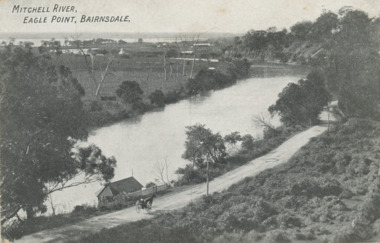
Postcard - Eagle Point bluff, silt Jetties and Jones' Bay, Eagle Point Victoria, A W Burman Bairnsdale, 1912 c
Letter on back dated Dec 30 1912 to Mrs Brewer Signed FloraBlack and white postcard showing view of Mitchell River looking east towards Eagle Point bluff and the silt Jetties and Jones' Bay small farm and buildings, hop kiln on bank opposite bluff and hop paddock. Horse and jinker on gravel road Eagle Point VictoriaMitchell River Eagle Point Bairnsdale waterways, rivers, jetties, roads and streets, transport -
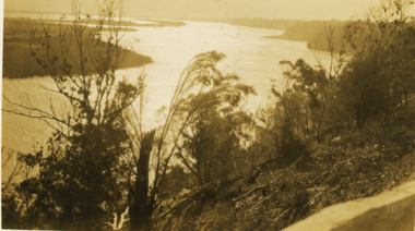
 Lakes Entrance Historical Society
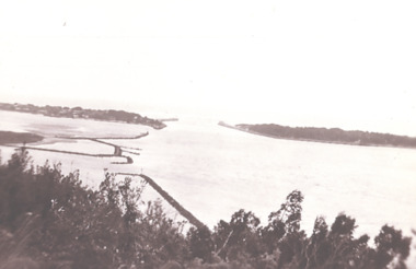
Photograph - View of Entrance from Jemmys Point, 1930 c
Black and white photograph of view of the entrance to the Gippsland Lakes from Jemmys Point showing end of Bullock Island Lakes Entrance Victoria waterways, islands, gippsland lakes -
 Lakes Entrance Historical Society
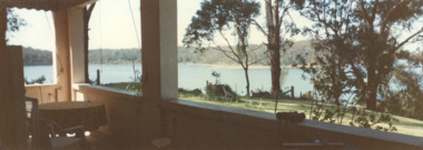
Photograph - Views from Mill Point house, Lake Tyers Victoria, 2000
... Photograph Views from Mill Point house ...Colour photograph taken from Mill Point house showing Lake Tyers Victoria. waterways, topography -
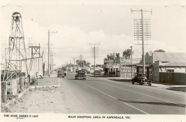 Chelsea & District Historical Society Inc
Photograph - Shopping Area, Aspendale, c 1930's
Black and white postcard showing shops on the right hand side of Point Nepean Road and the railway line, Aspendale railway station and the Aspendale Fire Station with the bell tower beside it. One car driving along the road and two cars parked. The shops in view are a cafe, a general store, the Aspendale Picnic Grounds, which included Palais De Dance.The Rose Series P. 1037 MAIN SHOPPING AREA IN ASPENDALE, VIC.point nepean road, nepean highway, aspendale, taylor avenue, shops, aspendale fire station, aspendale picnic grounds -
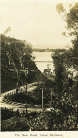 Lakes Entrance Historical Society
Postcard - The New Road Lakes Entrance, 1922 c
Also three postcards showing different views of the road around Jemmys Point 05281.1, .2 and .3Black and white postcard showing view of new alignment of the Princes Highway on Jemmys Point and part of the original high steep road approaching Lakes Entrance VictoriaThe New Road Lakes Entrance waterways, roads and streets -
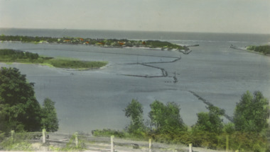
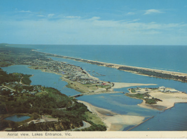
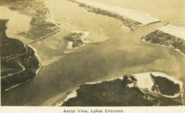 Lakes Entrance Historical Society
Postcard - Aerial view Lakes Entrance, H D Bulmer, 1922 c
Image clearly shows new alignment of Princes Highway around Jemmys Point and part of the original high road to the first bend above North Arm BridgeBlack and white postcard aerial view of the western area of the town, Bullock Island and Snake Island and waterways Lakes Entrance VictoriaAerial View Lakes Entrancewaterways, islands, township -
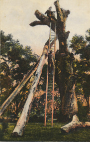 Lakes Entrance Historical Society
Postcard - Lookout Tree 1890, W T Potter, 1890 c
Black and white postcard of the tall trunk of a dead grey box tree supported by two heavy timber trusses, a long wooden ladder for access to the top area for viewing the lakes and ocean from Jemmys Point Kalimna VictoriaLookout tree Lakes Entrance Cunninghame Victorianavigation -
 Lakes Entrance Historical Society
Photograph - Reeves River, 1920 c
Also another black and white photograph of same view with a man in foreground 05298.1Black and white photograph showing view of Reeves River looking west towards Metung with islands Rigby and Flanagan on left and Nungurner on right Jemmys Point Lakes Entrancewaterways -
 Lakes Entrance Historical Society
Postcard - Aerial view Lakes Entrance, Murray View Gympie Qld, 1970 c
Also a second postcard lookin west showing township, North Arm and Kalimna Heights 05213.1 10 x 15 cmBlack and white postcards showing aerial views of township, North Arm and Cunninghame Arm, Bullock Island and part of Kalimna Heights and Jemmys Point Lakes Entrance VictoriaAerial view of Lakes Entrance Victownship, waterways, islands -
 Lakes Entrance Historical Society
Postcard - Lakes Entrance viewed from Jemmys Point, Rose Series, 1925 c
... postcard showing view of Cunninghame Arm from Jemmys Point, gravel ...Post and rail fence beside highway and no vegetation on sand dunes eastern part of Cunninghame ArmBlack and white postcard showing view of Cunninghame Arm from Jemmys Point, gravel Princes Highway, North Arm bridge and end of town Lakes Entrance VictoriaNearing Lakes Entrance on the Princes Highwaytownship, waterways -
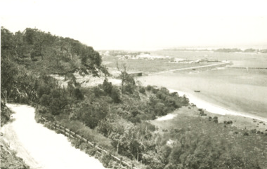
 Lakes Entrance Historical Society
Photograph - Jemmys Point roadway, 1924
View of road down Jemmys Point, hummocks and lake just visible in far distance Lakes Entrance Victoriaroads and streets, topography -
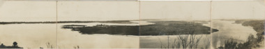 Lakes Entrance Historical Society
Postcard, Reeves Channel, Rigby Island, the entrance, Bullock Island , Lakes Entrance Victoria, 1920 c
Views of Gippsland Lakes from Jemmy's Point Lakes EntranceBlack and white panoramic folding postcard of the Gippsland Lakes including Reeves Channel, Rigby Island, the entrance, Bullock Island and Lakes Entrance township taken from Jemmys Point Lakes Entrance Victoria. Also panoramic postcard view from southern part of Rigby Island to Lakes Entrance township. And a third postcard "KALIMNA COVE LAKES ENTRANCE"waterways, gippsland lakes -
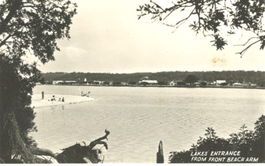 Lakes Entrance Historical Society
Postcard - Sand hummocks Lakes Entrance Victoria c1940
Black and white postcard taken from sand hummocks looking across Cunninghame Arm to township, sandy beach known as Play Point shown left centre of image Lakes Entrance Victoria c1940. Also two other black and white postcards showing similar viewsLakes Entrance from Front Beach Arm and Lakes Entrancee from the South Side waterways, vegetation, township, houses