Showing 1248 items
matching bay road
-
 Port Melbourne Historical & Preservation Society
Document - Property valuation working papers, Tom Piper Ltd, Williamstown Road, Port Melbourne, George Levey, 1950 - 1974
Sample of working papers relating to the valuation of 29 premises in Port Melbourne. These papers were maintained by Mr George LEVEY, who was the City Valuer for PMCC from around the mid 1950s to about 1974. Details are all in manilla folders. .23 - Tom Piper Ltd. Williamstown Roadbuilt environment - commercial, business and traders, industry, george levey, tom piper ltd -
Port Melbourne Historical & Preservation Society
Document - 2011 Melway Greater Melbourne Street Directory, 2011
2011 editions of Melway Greater Melbourne Street Directory Top quarter white, bottom blue background with photo of citybuilt environment, engineering - roads streets lanes and footpaths, natural environment, transport - roads, streets, mapping, greater melbourne -
Port Melbourne Historical & Preservation Society
Poster - 25th anniversary of Changi prisioners return to Australia, Alan Dower, The Road of Return, 1971
Given to PMH&PS by the local RSL Branch on their closure in May 1998The Road of Return' - 1971 pictorial poster detailing changi prison camp, produced on 25th Anniversary of prisoners' return to Australia, to promote an anniversary tour to ChangiInk mark lower leftsocieties clubs unions and other organisations, war - world war ii, returned services league, rsl -
Port Melbourne Historical & Preservation Society
Book - Minutes, Municipal Council of Sandridge - Beach Street Committee, 1861 - 1863
First minute book of the Beach Street Committee, 1861-1863. Standard Council notebook, with label 'Municipal Council of Sandridge - Beach Street Committee'local government - borough of sandridge, engineering - roads streets lanes and footpaths, built environment -
Port Melbourne Historical & Preservation Society
Photograph - Lagoon Confectioners employees, 1960
This was shot at former premises in Albert Road, and copied for a 'Farewell display' shown at 1999 Port Festival, Mayor's Day and Senior Cits Week events. Two of the women were still working with Lagoon after 40 years (ref. item 963.02)Lasercopy from black and white print loaned by Lagoon Confectioners: five women employees photographed in 1960. Left to right, Lil SAYERS, Margaret LANE, Mella and Pat MORIER, Phyl CAMILLERI. industry - food, lil sayers, margaret lane, mella morier, lagoon confectionery pty ltd, business and traders - confectioners, phyl spotkeiff nee camilleri, pat aquilina nee morier -
Port Melbourne Historical & Preservation Society
Photograph - Corner Bay and Little Bay Streets, Port Melbourne, 26 Oct 2007
Photo of corner Bay and Little Bay Streetsbuilt environment, engineering - roads streets lanes and footpaths, edwin whiting -
Port Melbourne Historical & Preservation Society
Photograph - Woolsheds between Beacon and Barak Roads, Port Melbourne, Don Hossack, 1947
Donated by Don Hossack who took the photograph when he was 16 years old and working at the woolsheds. He recalls that bags of oats and barley were stored here.Photo (10 x 12" glossy black and white print) of the wool sheds between Beacon and Barak Roads. Shows north easternmost sheds and rail line. The wool sheds were built by the Americans during World War II and taken down again in the 1950s . Map (hand drawn) on rear shows location of photograph.map (hand drawn) of location of photographtransport - railways, built environment - industrial, war - world war ii -
Port Melbourne Historical & Preservation Society
Photograph - Bridge Street, Then and Now series, David Thompson, 1996
Taken 1996 by David Thompson for "Then and Now""Bridge St - Then and Now" series. Bridge street, taken from near the tram crossing, looking towards Bay Street. Shows Station Hotel building, which had been converted into a private residence. (no 587 from series)built environment - commercial, built environment - domestic, engineering - roads streets lanes and footpaths, david thompson, bridge street, station hotel -
Port Melbourne Historical & Preservation Society
Photograph - Angela's garden, 26 Beacon Road, Port Melbourne, 2009
Memories of Angela's garden 26 Beacon Rd, Port Melbourne 2009built environment - domestic, angela drew -
Port Melbourne Historical & Preservation Society
Photograph - Corner Bay and Bridge Streets, Port Melbourne, looking north, 1956
Photo is part of Glen Stuart's home movie on "City of Port Melbourne" - extracted by David Thompson from DVD copyPhoto of corner of Bay and Bridge Streets looking North, 1956built environment - commercial, engineering - roads streets lanes and footpaths, bay street, bridge street -
Port Melbourne Historical & Preservation Society
Photograph - 488 Williamstown Road, Port Melbourne, David Thompson, 2000s
Photo of David and Liana Thompson's house at 488 Wiliamstown Rdbuilt environment - domestic, david thompson, liana thompson -
Port Melbourne Historical & Preservation Society
Photograph - Gilbert Transport, Ross Street, Port Melbourne, David Thompson, 2009
Colour photograph of Ross Street looking towards the city; shows Gilbert Transport building which beforehand was Russell Carriers. Photo taken 2009engineering - roads streets lanes and footpaths, russell carriers, gilbert transport, ross street -
Port Melbourne Historical & Preservation Society
Plan - Water cart used in road construction, Borough of Sandridge, 21 Nov 1870
From a group of maps and plans not required by the Port Melbourne Council Engineering Department in May 1994 and offered at that time to the Port Melbourne Historical Society.Plan of water cart used in road construction including 4 diagrams and scales: signed by Borough Surveyor, Nov 21 1870.built environment - civic, engineering, engineering department - borough of sandridge -
Port Melbourne Historical & Preservation Society
Plan - Sandridge, Department of Lands and Survey, "The Township of Sandridge", 5 Nov 1860
Map of Sandridge, lithographed 1860, showing subdivisions on Evans Street, but no other development West of the railway Lihographed at the Department of lands and Survey, Melbourne 5th November 1860. Hand drawn annotations added at unknown date.Hand written "clay ground" 18 chains long, 7.5 chains broad, 26 chains from railwayengineering - roads streets lanes and footpaths, sandridge lagoon, transport - railways, town planning, local government - borough of sandridge -
Port Melbourne Historical & Preservation Society
Plan - Heath Street, Bridge Street and Spring Street, Sandridge, 16 Mar 1868
Plan of Heath, Bridge, North and South Spring Streets 1868 showing Bay St, Raglan St,Spring St, and Nott St, labelled. Spring St North, Spring St South, Bridge St and Heath St unlabelled; and transverse sections of the streets with measurements.Signed "Peter Mackey, Nicholas Mackey 16/5/68" Other names have been crossed out with pencil.built environment - civic, engineering department - borough of sandridge, engineering - roads streets lanes and footpaths, heath street, bridge street, borough of sandridge -
Port Melbourne Historical & Preservation Society
Plan, The Township of Sandridge, 30 Mar 1859
Plan of the township of Sandridge.Lithographed at the Public Lands Office, Melbourne, March 30th 1859engineering - roads streets lanes and footpaths, municipal district of sandridge -
Port Melbourne Historical & Preservation Society
Plan, Department of Lands and Survey, The Township of Sandridge, 25 Nov 1860
Plan of the township of Sandridge lithographed at the department of Lands and Survey, Melbourne 5th November, 1860. Identical to 1859 version except for added rail line through Sandridge and onto Town Pierengineering - roads streets lanes and footpaths, municipal district of sandridge -
 Port Melbourne Historical & Preservation Society
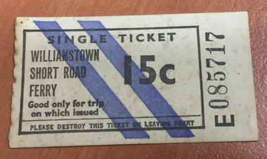
Document - Ferry Ticket, Williamstown Short Road Ferry, 1970s
Kept by Les Pont, donated to Society in August 1998Single ticket for the Williamstown Short Road Ferry (the 'Punt') 15c - oatmeal coloured with two diagonal purple stripes. (Instructions read 'Please destroy this ticket on leaving ferry')transport - ferries, williamstown -
Port Melbourne Historical & Preservation Society
Photograph - DISCO motif, GMH education centre, Williamstown Road, Port Melbourne, David Thompson, Aug 1998
Examples of 'art deco' buildings and motifs around Port Melbourne were drawn from David Thompson's existing collection and augmented by shots taken in August 1998.From series of 'deco' detailing and buildings taken by David Thompson for use in PMH&PS 1999 calendar, taken in August 1998: GMH education centre in Williamstown Road - disco motifDetails in pen on backarchitecture, built environment - industrial, david thompson, general motors-holden, gmh -
Port Melbourne Historical & Preservation Society
Photograph - GMH education centre, Williamstown Road, Port Melbourne, David Thompson, Aug 1998
Examples of 'art deco' buildings and motifs around Port Melbourne were drawn from David Thompson's existing collection and augmented by shots taken in August 1998.From series of 'deco' detailing and buildings taken by David Thompson for use in PMH&PS 1999 calendar, taken in August 1998: GMH Education centre, Williamstown RoadDetails in pen on backindustry, architecture, built environment - industrial, david thompson, general motors-holden, gmh -
Port Melbourne Historical & Preservation Society
Photograph - GMH education centre, Williamstown Road, Port Melbourne, David Thompson, Aug 1998
Examples of 'art deco' buildings and motifs around Port Melbourne were drawn from David Thompson's existing collection and augmented by shots taken in August 1998.From series of 'deco' detailing and buildings taken by David Thompson for use in PMH&PS 1999 calendar, taken in August 1998: GMH Education centre, Williamstown Road, corner detailDetails in pen on backindustry, architecture, built environment - industrial, david thompson, general motors-holden, gmh -
Port Melbourne Historical & Preservation Society
Book - Borough of Sandridge/Port Melbourne, Surveyor's correspondence, Charles Clay, Borough Surveyor et al, 1877
Book of Sandridge/Port Melbourne Borough Surveyors' correspondence copies, 1877 - 1890 re various contracts, streets, abattoirs, other engineering projects etc.local government - borough of sandridge, local government - borough of port melbourne, engineering - roads streets lanes and footpaths, arthur victor heath, town clerks, charles clay -
Port Melbourne Historical & Preservation Society
Functional object - Missions to Seamen building, Port Melbourne, BI Ltd, 1937
Liana THOMPSON, Mayor of Port Phillip at the time, purchased many of the bricks from the demolished Mission and used them to pave their yard at 488 Williamstown Road. She and David saved two for PMH&PSTwo bricks from the 1937 Missions to Seamen building demolished 1995. Salmon coloured, with bits of mortar; impressed one side with 'BI Ltd'mission to seamen, demolitions, liana thompson, harry a norris -
Port Melbourne Historical & Preservation Society
Article - Newspaper clipping, Meeting, Sandridge Borough Council, "EPA Work", 5 Mar 1878
Report (photocopy) on Sandridge Borough Council meeting on Tuesday, March 5th 1878, in the Record, March 8th 1878. Highlighted is reference to the making of a footpath on Ross St, of interest to ratepayers, in particular a Mr Kennett (perhaps Caleb?)local government - borough of sandridge, engineering department - borough of sandridge, engineering - roads streets lanes and footpaths, caleb (?) kennett, borough of sandridge -
Port Melbourne Historical & Preservation Society
Book, Terry Keenan, "The Road Less Travelled - Port Melbourne Stands Alone", May 2012
Written following the amazing 2011 season and premiership and published the week PMFC won their 28th consecutive match (the next week they lost to Colingwood).Signed copy of "The Road Less Travelled - Port Melbourne Stands Alone" a 148 page paperback by Terry KEENAN. Cover apple green with red, navy and white lettering (colour photograph by David THOMPSON, front and back cover). A coverage of the six stand-alone years for the PMFC, from 2006 to the 2012 undefeated premiership.Signed by author on title pagepeter saultry, terry keenan, gary ayres, pmfc, port melbourne football club, sport - australian rules football -
Port Melbourne Historical & Preservation Society
Book, Universal Business Directories (Aust) Pty Ltd, Universal DeLuxe Streets Directory, 1959
1959 Streets Directory for Melbourne City and Suburbs including large scale maps, hospitals, schools, police stations, town halls, telephone booths, tram stops, railways. Fifth edition. Red and Buff cardboard cover, red binding.transport - roads, street directory -
Port Melbourne Historical & Preservation Society
Plan - Construction of Liardet Street, Port Melbourne, John Foly?, Draughtsperson, 1860 - 1884
Working drawing: longitudinal section, ground plan, transverse section for the construction of Liardet Street between Nott Street and Railway Place. Between 1860 and 1884."Borough of Sandridge":"Chas Clay":"John Foly"engineering - roads streets lanes and footpaths, engineering department - borough of sandridge, charles clay, john foly, liardet street -
Port Melbourne Historical & Preservation Society
Plan, A J Duncan, Draughtsman, Plans and Sections of Tramsway, May 1891
Plans and typeset descriptions of a proposal to run a cable tram under the Yarra from Williamstown to Melbourne (Falls Bridge) via Port Melbourne. Oriniginally submitted to Victorian Legislative Assembly 1889; this updated 1891 version has 10 pages, and includes an added section to take tramway to Sandridge Road as far as St. Kilda Road. A company has now formed to back the proposal being re-presented to the Legislative Assembly.Signed by Edward Clark 2-6-1891, with Borough stamp on cover; initialed, ditto, on page 2; signed by A.J. Duncan page 2.transport - tramways, town planning - proposals shelved, williamstown, edward clark, town clerks, mr jennings, austral - anglo tramway and general agency co ltd, a j duncan -
Port Melbourne Historical & Preservation Society
Plan, A J Duncan, Draughtsman, Plans and Sections of Tramsway, May 1891
Plans and typeset descriptions of a proposal to run a cable tram under the Yarra from Williamstown to Melbourne (Falls Bridge) via Port Melbourne. Oriniginally submitted to Victorian Legislative Assembly 1889; this updated 1891 version has 10 pages, and includes an added section to take tramway to Sandridge Road as far as St. Kilda Road. A company has now formed to back the proposal being re-presented to the Legislative Assembly. (Copy of 46.2)Signed by Edward Clark 2-6-1891, with Borough stamp on cover; initialed, ditto, on page 2; signed by A.J. Duncan page 2.transport - tramways, town planning - proposals shelved, williamstown, edward clark, town clerks, mr jennings, austral - anglo tramway and general agency co ltd, a j duncan -
Port Melbourne Historical & Preservation Society
Drawing - Sketch (copy), Proposed Military Road, St Kilda to Sandridge, 4 Apr 1865
Original proposal instigated by the Crimean War and Russian invasion scare.Copy (1865) of 1860 sketch of proposed Military Road from St. Kilda to Sandridge to link all local batteriesSigned by P. H. Scratchleytown planning - proposals shelved, war, batteries - defensive, p h scratchley, st kilda