Showing 33220 items matching "buildings/streetscapes"
-
 Vision Australia
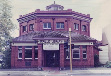
Photograph - Image, Braille and Talking Book Library in Commercial Road
Built in 1918-1919, this distinctly styled building was constructed with the needs of returned blind soldiers in mind by architects Anketell and Henderson. Matting tracks were placed in the single level floor and handrails on the wall to guide users around the building. In 1929, two stained glass windows were constructed and placed in the building to commemorate the 120th anniversary of Louis Braille's birth. (These were removed and transferred to Kooyong when the library moved its operations in 2002.) The building is listed on the Victorian Heritage Register.1 x col. photograph of red brick octagonal buildingbraille and talking book library, tilly aston -
 Sunbury Family History and Heritage Society Inc.
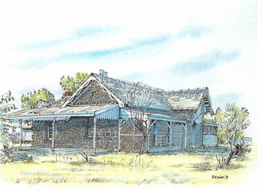
Photograph, Bill Walls, c1978
The building in the sketch is the former Manse for the Bulla Presbyterian Church. The artist was Bill Walls who did a number of similar sketches of historic buildings and sites in the Sunbury and Bulla area in the 1970s.A photograp[h of a coloured sketch of a house with bluestone walls and a slate roof. There is a closed-in addition building on one side and a verandah across the front with a lean-to structure on the other end of the building.bulla, presbyterian church, manse -
 Eltham District Historical Society Inc
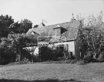
Photograph, Pise building, Montsalvat (1934-1935)
First Montsalvat pise building, Built 1934-35, Designed by Justus Jorgensen, Founder of Montsalvat. This building was used for many years as a dining room and kitchen. The Alistair Knox Collection (Image 2A) The Alistair Knox Collection is a series of mounted enlarged photos of mud brick houses and related subjects. The collection is understood to have been put together by Alistair Knox although it is the work of several unacknowledged photographers. For some years it was held by the Building Department of the former Eltham Shire Council and was then passed to our Society for safekeeping. Some of the photos have been used in Knox's books and from time to time some of them have been part of various historical displays. As far as we know there has not been a public display of the whole collection which numbers about forty photographs. The collection has been copied on to slides for the purpose of this meeting and to be retained as part of the Society's pictorial collection. Alistair Knox 1912 - 1986 is acknowledged as the founder of Eltham's mud brick building movement. Many of the buildings shown in the collection are of his design and he was also involved with the construction of several of them. Others are the work of his contemporaries and associates such as Peter Glass, Gordon Ford, and John Harcourt. (EDHS Newsletter No. 145 July 2002)Handwritten notes in pencil re details of building, year of construction, owner, designer, builder, etcmontsalvat, houses, justus jorgensen, pise construction, alistair knox collection -
 Bendigo Historical Society Inc.
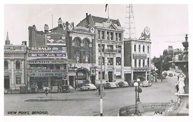
Postcard - VIEW POINT, BENDIGO
black and white photo: View Point, Bendigo. Alexandra Fountain on Rh side, View Street , Armstrong Tyre Service, Australian Mutual Provident Society, Colonial Mutual Life Building, Greyhound Racing buildings in streetscape. Cars parked along kerb. ? Late 1930's early 1940's. On bottom of photo: View Point, Bendigo. No. 14. On back ' Valentine's Post Card, sending you greetings, for address only.Valentine's Post Cardplace, streetscape, view point, view point, alexandra fountain, view street, armstrong tyre service -
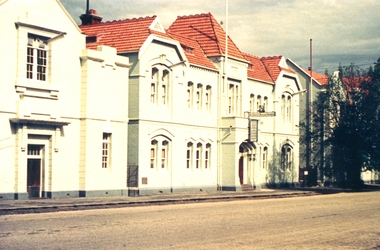 Federation University Historical Collection
Photograph - Colour photograph, Ballarat School of Mines Administration Building, c1960s
The brick buildings were painted blue around the 1960s, and were later sandblasted to return them to red brick colour. Buildings of the Ballarat School of Mines from Lydiard Street South. The brick buildings have all been painted pale blue. ballarat school of mines, lydirad street south, administration building, a building, former wesleyan church, ballarat technical art school -
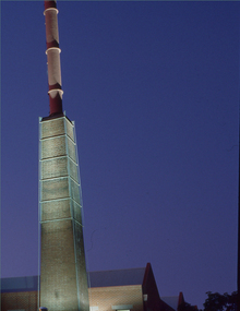 Federation University Historical Collection
Negative - Photograph, Ballarat School of Mines Brewery Building
... buildings ...A building on the Federation University SMB Campus. It is built on the site of the former Ballarat Brewery.2 transparencies of the Brewery building on SMB Campusbrewery building, ballarat school of mines, buildings, chimney -
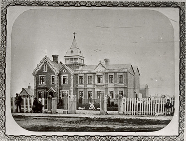
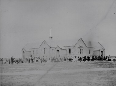 Stawell Historical Society Inc
Photograph, Common School Pleasant Creek 502 in 1866
Common School Pleasant Creek 502. Part of a collection of Photographs by Mr. O.G. Armstrong as commissioned by the Shire of Stawell for the Inter-colonial and Paris Exhibition in Melbourne in 1866. The site for the school pictured was reserved in October 1864 and the building was opened in 1865. The brick building is still in use and is at the rear of the current 502 Primary School buildings, Barnes Street. Large brick and stone school building with students and teachers at front.stawell education -
 Federation University Historical Collection
Photograph, Clare Gervasoni, Brewery Complex at Federation Australia SMB Campus, 2011, 06/10/2011
... buildings ...The brewery building was built on the site of the Ballarat Brewery. It is part of the Ballarat School of Mines Campus.Photographs of a red brick building with large chimney. The building is the Brewery Complex at Federation University Australia SMB Campus. The chimney is a remnant for the Ballarat Brewery. federation university, federation university australia, feduni, smb campus, ballarat school of mines, brewery complex, ballarat brewery, buildings -
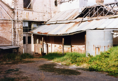 Charlton Golden Grains Museum Inc
Photograph, Brownjohn, Reg, Rear of Johnson's Bridge Store c. 2000, c.2000
Derelict rear of building built as Bridge Store in 1872 for Peter Johnson, later Wylie's Building and a furniture store. Photo taken for the Museum.Colour photograph of the rear of an old, brick two storey building. Building appears derelict and disused. Not all the building is in the photo. Old rainwater tank on RH side, part of the roof is missing and the beams are exposed. Gas tank/hot water service in corner in the centre of the photo. Single door to the right of the gas tank and double doors to the left.bridge store, peter johnson, wylie's building, business -
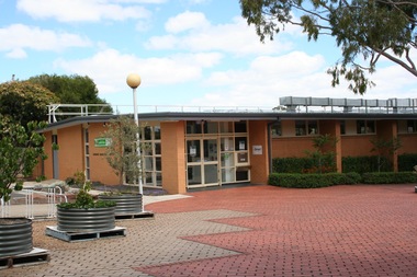 Sunbury Family History and Heritage Society Inc.
Photograph, Rosa McCall, Former Sunbury Library, December 2017
The building pictured is the former Sunbury Library which closed in December 2017 to be demolished and to make way for a modern three storey building more suited to updated library needs. A coloured printed digital photograph of brick paved open area leading to the entrance of a single storey cream brick building. Some plants are growing in three metal planters in front of the buildingsunbury library, libraries -
 Kew Historical Society Inc
Plan, Melbourne & Metropolitan Board of Works : Borough of Kew : Detail Plan No.1592, 1905
The Melbourne and Metropolitan Board of Works (MMBW) plans were produced from the 1890s to the 1950s. They were crucial to the design and development of Melbourne's sewerage and drainage system. The plans, at a scale of 40 feet to 1 inch (1:480), provide a detailed historical record of Melbourne streetscapes and environmental features. Each plan covers one or two street blocks (roughly six streets), showing details of buildings, including garden layouts and ownership boundaries, and features such as laneways, drains, bridges, parks, municipal boundaries and other prominent landmarks as they existed at the time each plan was produced. (Source: State Library of Victoria). This plan forms part of a large group of MMBW plans and maps that was donated to the Society by the Mr Poulter, City Engineer of the City of Kew in 1989. Within this collection, thirty-five hand-coloured plans, backed with linen, are of statewide significance as they include annotations that provide details of construction materials used in buildings in the first decade of the 20th century as well as additional information about land ownership and usage. The copies in the Public Record Office Victoria and the State Library of Victoria are monochrome versions which do not denote building materials so that the maps in this collection are invaluable and unique tools for researchers and heritage consultants. A number of the plans are not held in the collection of the State Library of Victoria so they have the additional attribute of rarity.Original survey plan, issued by the MMBW to a contractor with responsibility for constructing sewers in the area identified on the plan within the Borough of Kew. The plan was at some stage hand-coloured, possibly by the contractor, but more likely by officers working in the Engineering Department of the Borough and later Town, then City of Kew. The hand-coloured sections of buildings on the plan were used to denote masonry or brick constructions (pink), weatherboard constructions (yellow), and public buildings (grey). In MMBW Plan No.1592, the pink line indicates that area of the plan for which the contracting engineer was responsible. Included in the Plan are a number of primarily brick villas in a section of Belmont Avenue off Cotham Road. The house ‘Uvadale’ north of Belmont Avenue, and facing Cotham Road is also included in the contract. Excluded from the contract but shown on the Plan are ‘Glendonald’, ‘Mont Belmont’ and ‘Gilden’.melbourne and metropolitan board of works, detail plans, survey plans - borough of kew, mmbw 1592, cartography -
 Kew Historical Society Inc
Plan, Melbourne & Metropolitan Board of Works : Borough of Kew : Detail Plan No.1561, 1905
The Melbourne and Metropolitan Board of Works (MMBW) plans were produced from the 1890s to the 1950s. They were crucial to the design and development of Melbourne's sewerage and drainage system. The plans, at a scale of 40 feet to 1 inch (1:480), provide a detailed historical record of Melbourne streetscapes and environmental features. Each plan covers one or two street blocks (roughly six streets), showing details of buildings, including garden layouts and ownership boundaries, and features such as laneways, drains, bridges, parks, municipal boundaries and other prominent landmarks as they existed at the time each plan was produced. (Source: State Library of Victoria). This plan forms part of a large group of MMBW plans and maps that was donated to the Society by Mr Poulter, City Engineer of the City of Kew in 1989. Within this collection, thirty-five hand-coloured plans, backed with linen, are of statewide significance as they include annotations that provide details of construction materials used in buildings in the first decade of the 20th century as well as additional information about land ownership and usage. The copies in the Public Record Office Victoria and the State Library of Victoria are monochrome versions which do not denote building materials so that the maps in this collection are invaluable and unique tools for researchers and heritage consultants. A number of the plans are not held in the collection of the State Library of Victoria so they have the additional attribute of rarity.Original survey plan, issued by the MMBW to a contractor with responsibility for constructing sewers in the area identified on the plan within the Borough of Kew. The plan was at some stage hand-coloured, possibly by the contractor, but more likely by officers working in the Engineering Department of the Borough and later Town, then City of Kew. The hand-coloured sections of buildings on the plan were used to denote masonry or brick constructions (pink), weatherboard constructions (yellow), and public buildings (grey). MMBW Detail Plan 1561 outlines those residences in the area bordered by Burke Road, Loxton Street, Mount Street and Barkers Road that had been constructed by 1905 when the land was surveyed. At this time, the area nearest Burke Road had been subdivided and developed whereas the lands to the west were as yet undeveloped. The houses represented are not named on the Plan.melbourne and metropolitan board of works, detail plans, mmbw 1561, cartography -
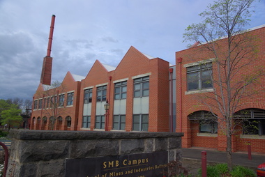
 Federation University Historical Collection
Photograph- Colour, Framed photograph of Morgan B. John and opening plaque at the opening of the Ballarat School of Mines M.B. John Building, 1987, 11/06/1987
... buildings ...Framed photograph of Morgan B. John and opening plaque at the opening of the Ballarat School of Mines M.B. John Building.The Ballarat School of Mines &Industries Ballarat Established 1870 This plaque commemorates the official opening of the M.B. John Building on 11th June 1887 by The Honourable John Cain M.P. Premier of Victoriaballarat school of mines buildings, m.b. john building, m.b. john, morgan b. john, john cain, visitors, buildings, opening, plaque -
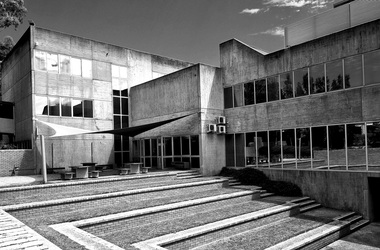
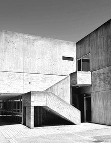 Federation University Historical Collection
Photograph, Building D Mount Helen Campus, by Lucie Akers, 2023
Building D at Mount Helen Campus, Federation University. Currently (2024) inhabits university administration, AEC Centre, Disability Services, and VC Offices. This building was designed by architect Ewan Jones. Building D Mount Helen Campus, by Lucie Akers, 2023brutalism, federation university australia, mount helen campus, architect, education, building d, ewan jones and associates -
 Kew Historical Society Inc
Plan, Melbourne & Metropolitan Board of Works. Borough of Kew Detail Plan No.1579, 1904
The Melbourne and Metropolitan Board of Works (MMBW) plans were produced from the 1890s to the 1950s. They were crucial to the design and development of Melbourne's sewerage and drainage system. The plans, at a scale of 40 feet to 1 inch (1:480), provide a detailed historical record of Melbourne streetscapes and environmental features. Each plan covers one or two street blocks (roughly six streets), showing details of buildings, including garden layouts and ownership boundaries, and features such as laneways, drains, bridges, parks, municipal boundaries and other prominent landmarks as they existed at the time each plan was produced. (Source: State Library of Victoria). This plan forms part of a large group of MMBW plans and maps that was donated to the Society by the Mr Poulter, City Engineer of the City of Kew in 1989. Within this collection, thirty-five hand-coloured plans, backed with linen, are of statewide significance as they include annotations that provide details of construction materials used in buildings in the first decade of the 20th century as well as additional information about land ownership and usage. The copies in the Public Record Office Victoria and the State Library of Victoria are monochrome versions which do not denote building materials so that the maps in this collection are invaluable and unique tools for researchers and heritage consultants. A number of the plans are not held in the collection of the State Library of Victoria so they have the additional attribute of rarity.Original survey plan, issued by the MMBW to a contractor with responsibility for constructing sewers in the area identified on the plan within the Borough of Kew. The plan was at some stage hand-coloured, possibly by the contractor, but more likely by officers working in the Engineering Department of the Borough and later Town, then City of Kew. The hand-coloured sections of buildings on the plan were used to denote masonry or brick constructions (pink), weatherboard constructions (yellow), and public buildings (grey). While MMBW Plan No.1579 does not include many buildings, those that it does show are significant to Kew’s history. These include the ‘Kew [Railway] Station’ in Denmark Street and the ‘Recreation Hall’ and rear courts off Wellington Street. The plan shows the outline of the Recreation Hall, constructed in 1880, at the rear of which is listed a bowling green, two tennis courts, a ‘skittle alley’ and a pavilion. When the Hall was first built, the Kew Cricket Club occupied an adjacent ground, however in 1885 this was acquired by the State Government as the future location of the Kew Railway Station. The Plan also shows a single oval at Xavier College. This oval was completed in 1883. One of the current ovals conforms to this oval’s original shape and position in the school grounds.melbourne and metropolitan board of works, detail plans, maps - borough of kew, mmbw 1579, cartography -
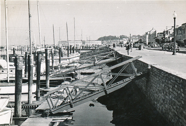 Mission to Seafarers Victoria
Photograph - Photograph, Black and white, Allan Charles Quinn, Landing Docks, 30 September 1949
Allan Charles Quinn went to sea aged 16 and photographed his work and the places he visited. His collection of photo albums provides a pictorial autobiography for a period in his life. Included in the Allan Charles Quinn Collection are a series of letters written to and from his mother.Black and white photograph of landing docks at San Francisco. To the right of the photograph is the streetscape which includes a walking track and street lighting in front of a road and row of shops or houses. To the centre of the photograph are the ramps to reach the jetty where the yachts are moored. To the left of the photograph are the bows of a long line of yachts. In the background of the photograph there is a large multi-storeyed building.Blue/green ink, handwritten on reverse: "30/9/49" Handwritten in pencil: "K9/A"san francisco, sailing boats, ramps, promenades, allan charles quinn -
 Federation University Historical Collection
Painting - Photo, Clare Gervasoni, S Building, Mt Helen Campus, 08/04/2018
The E.J. Barker Library was one of the earlier building on the Federation University Mount Helen campus.S Building Mt Helen campus library. brutalism, brutalist, mount helen campus, s builidng -
 Federation University Historical Collection
Photograph - Photograph - black and white, Benevolent Asylum Ballarat, 1861
The Ballarat Benevolent Asylum is an early Ballarat institution. The Building depicted was demolished and is now the site of the Queen Elizabeth centre. Black and white photograph of an early Ballarat building. It is the double storey building known as the Ballarat Benevolent Asylum (Later the Queen Elizabeth Centre) ballarat, benevolent asylum, asylum, ballarat benevolent asylum, queen elizabeth benevolent asylum, welfare, queen elizabeth home -
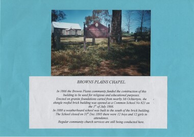 Rutherglen Historical Society
Image, c1985
Colour photograph of a small painted brick building with a story board in front of it. The photograph is mounted on a bright blue sheet of paper, along with a typed caption of the text from the story board.Caption text: "Browns Plains Chapel. In 1866 the Browns Plains community funded the construction of this building to be used for religious and educational purposes. Erected on granite foundations carted from nearby Mt Ochtertyre, the shingle roofed brick building was opened as a Common School No 821 on the 1st of July 1866. In 1880 a weatherboard school was built to the south of the brick building. The School closed on 31st Dec 1895 there were 12 boys and 12 girls in attendance. Regular community church services are still being conducted here."browns plains, churches, schools, common school no 821 -
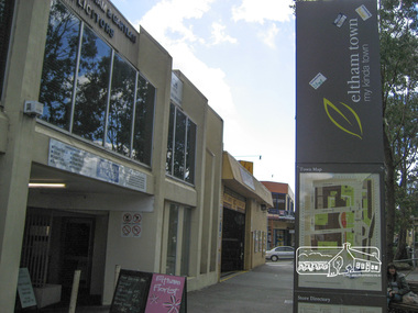
 Eltham District Historical Society Inc
Photograph, Liz Pidgeon, Commercial Place, Eltham, 15 April 2011, 15 April 2011
Streetscape and shop developmentsBorn Digitaleltham, commercial place, shopping centre -
 Eltham District Historical Society Inc
Photograph, Liz Pidgeon, Commercial Place, Eltham, 15 April 2011, 15 April 2011
Streetscape and shop developmentsBorn Digitaleltham, commercial place, shopping centre -
 Eltham District Historical Society Inc
Photograph, Liz Pidgeon, Commercial Place, Eltham, 15 April 2011, 15 April 2011
Streetscape and shop developmentsBorn Digitaleltham, commercial place, shopping centre -
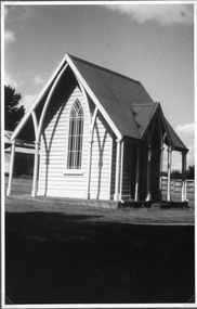 Stawell Historical Society Inc
Photograph, Lodge Building near the Cemetery Entrance
Lodge building at Stawell Cemetery entrance. This small building inside the cemetery gates in earlier years was used by clergy to change into their robes also by horse drawn vehicles. Black & White photograph of a church like weather board building with a steep iron roof. The building has a lancet window and narrow veranda and is located at the entrance to the Stawell cemetery. Photograph taken in 1984.stawell cemetery -
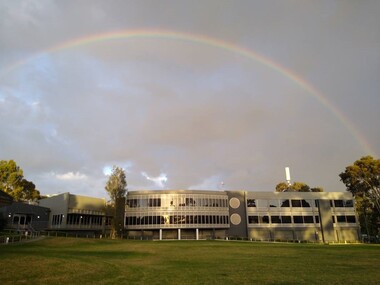 Vision Australia
Photograph (item) - Image, Jason Morgan, Happy work day, 23/2/2021
... Buildings ...Photograph taken by a staff member of the rear view of the Kooyong building, facing the blind cricket ground. There is a rainbow above the building, visible against the stormy clouds.vision australia, buildings -
Glenelg Shire Council Cultural Collection
Photograph - Photograph - Julia Street Porrtland, c. 1970
Photographic print of a rephotographed photograph. Image of north side of Julia Street between Percy and Bentinck Streets. Bluestone buildings - Woolstores of Henty, Learmonth & Co, Bank of Australasia on right. Numerous people on footpath.Front: 'Henty Woolstore - 2 Observer Buildings, Julia Street' - green ink Back: 'Bayview and Observer Printers' - blue biro -
 Federation University Historical Collection
Mount Helen Campus Building T, by Lucie Akers, 2023
Building T at Mount Helen CampusSide View of Building T, taken from outdoor amphitheater. brutalism, federation university australia, mount helen campus, concrete, education, t building -
 Port of Echuca
A rectangular coloured photograph, 1979
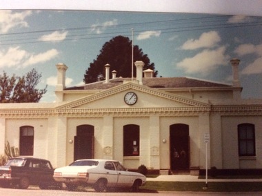
This is a picture of the original Town Hall building built in High Street in the 1890's. It was designed by renowned Bendigo Architect W.C .Vahland. This picture was taken in 1979 when the Echuca Library was housed there. The Echuca Library operated out of this building from 1965 up to 2013 when the new library was built. In this photograph there are two people standing in the doorway and two cars parked in the street.This photograph is significant because it shows the first Town Hall building built in High Street in the late 1890's. The building was designed by W.C Vahland and was also used as the Law Courts before the Law Court building was built in Law Court Place. This building has also been used as the High School, while the Echuca High School was being built in the 1920's it was also used as a Kindergarten and the town Library operated there from 1965 to 2012 when the new Library was built. The Shire of Campaspe Information Technology Department has been housed there from 2012 up to the Present.A coloured photograph, in postcard size, of the original Town Hall building of Echuca, taken in 1979, when the building was being used as the Echuca Library.echuca town hall, echuca library, vahland, w.c -
 University of Melbourne, Burnley Campus Archives
Photograph - Black and white print, Information Branch Victorian Department of Agriculture, Opening of Student Amenities Building, 1973
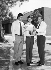
Outside the Student Amenities Building, left to right: Ian Smith, Minister for Agriculture, Brian Ward, Dux of College, R.J. Hamer, Premier of Victoria. On reverse, "Opening of Student Amenities Building and Graduation Ceremony 13/12/1973," and, "Photograph by Information Branch Victorian Department Of Agriculture Ref. No. E 206 (2)."student amenities building, ian smith, minister for agriculture, brian ward, dux of college, r.j. hamer, premier of victoria, graduation ceremony, 1973 -
 Federation University Historical Collection
Document, Ballarat School of Mines Science Building and Workshops Extension, 1912-13, 1912-1913
The Science Building and Workshops were built by J. and W. Souter in 1913.Documents relating to the building extensions to the Ballara SChool of Mines Science building and workshops. Includes correspondence from the Victorian Education Department and progress payments on both projects. ballarat school of mines, science building, workshops, j. souter, w. souter, j. & w. souter, h. armour, hugh armour -
Frankston RSL Sub Branch
Glass, Souvenir
A wine glass. This glass was made for the 6th anniversary celebrations of the opening of the new Frankston Returned & Services League of Australia club building held in 1982. The glass features an image of the new club building and details of the history of the club in gold leaf applied to the external surface of the glass. The glass is made from clear glass and is gold lipped.This glass is inscribed with the following in gold leaf: "FRANKSTON R.S.L. 6th ANNIVERSARY 1982" beneath an image of the new club building and a brief précis of the major events in the club history.