Showing 1536 items
matching clarke
-
 Warrnambool and District Historical Society Inc.
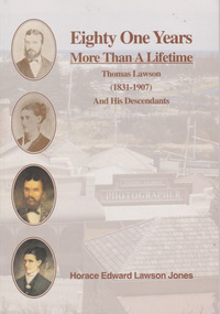
Book, Helen Lawson Jones, Eighty One Years More than a Lifetime Thomas Lawson (1831-1907) And his descendants, 1994
Family history of Thomas Lawson (1831-1907) and his descendantsThis is a paper back book with a plasticized cove which has an image of Flagstaff Hill Maritime Village (reproduction of Daniel Clarke’s Studio) in the background in muted colours, photographs and paintings of Thomas and Susan Lawson in colour on the front cover and a photograph of and information on the author on the back. It has 37 pages, a Lawson family tree at the back and an introduction by Helen Jones. The book included printed material, black and white photographs and illustrative material.non-fictionFamily history of Thomas Lawson (1831-1907) and his descendants lawson family, warrnambool, cobden, camperdown -
 Bendigo Historical Society Inc.
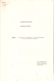
Document - RESEARCH PROJECT: A TRACING OF BENDIGO'S URBAN DEVELOPMENT IN THE 19TH CENTURY, 12/09/1980
(''A tracing of Bendigo's urban development in the 19th century'') - a 9 paged Research Project; Australian History; T.O.P. Year 12 General Studies; author - Val Pendlebury; 12/9/1980. Reference to: Henry Carey Bennett; Howards Coaches; Camp Street; Auction Street; Captain Andrew Clarke; Theatre Royal; William Larritt; Municipal Council; Bendigo Water Works Company; Big Hill reservoir; Vahland. Bibliography.Val Pendleburybendigo, history, 19th century bendigo, henry carey bennett, howards coaches, camp street, austion street, theatre royal, municipal council, bendigo water works. big hill reservior, vahland. william larritt. -
 Bendigo Historical Society Inc.
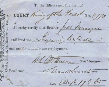
Document - ANCIENT ORDER OF FORESTERS NO 3770 COLLECTION: DOCTOR'S CERTIFICATE
Blue Doctor's Certificate dated Aug 17 1865 certifying that Pat Minogue of Sandhurst was unable to follow his usual employment. Signed by H. L. Atkinson, Court Surgeon. Printed by Bro. Clarke, Printer, 84, Moor Street, Fitzroy. Attached are two notes, the first, declaring himself on the Sick Fund and signed with his mark. The second is a note declaring himself off the Sick Fund and has his mark on it.societies, aof, correspondence, ancient order of foresters no 3770 collection - doctor's certificate, court king of the forest, pat minogue, h l atkinson, bro clarke -
 Bendigo Historical Society Inc.
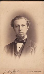
Photograph - ELMA WINSLADE WELLS COLLECTION: PHOTO OF MR. SNOWDON
A small black and white photograph of Mr. Snowdon partner of (first name unreadable) Rotherham. A relative of Elma Winslade Wells. Mr. Snowdon is wearing a white shirt with a bow tie, jacket and overcoat. He has dark hair combed back with curls, he also has a beard. On the back the logo of J. W. Clarke, artist and photographer, 7 Angel Hill opposite Abbey Gate Bury St. Edmunds.person, individual, mr. snowdon -
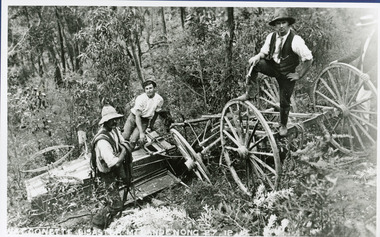 Mt Dandenong & District Historical Society Inc.
Photograph, The Wagonette Disaster 27th December 1911, 1911
This accident occurred at Devil's Elbow where now the Old Coach Road and Jasper Road meet at a cliff face. John Lundy-Clarke wrote a ballad about the mishap, probably combining fact and fancy. The wagonette was returning from an excursion to the Brooklyn Guest House in Montrose. Apparently only the horses were killed in the accident. See 'The Brooklyn Dray". The photograph shows local men inspecting the wreckage. (Not passengers as they were injured).devil's elbow, kalorama, john lundy-clarke, wagonette -
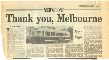 Melbourne Tram Museum
Newspaper, Herald Sun, "Thank you, Melbourne", 11/08/1991 12:00:00 AM
Newspaper clipping from the Herald-Sun, Sunday 11/8/1991, titled "Thank you, Melbourne", written by Michael Ryan about saving Melbourne's W class trams. Premier Joan Kirner announced a moratorium on scrapping or selling the previous Wednesday. Gives background to the tramcars and their use. Notes a comment from David Clarke, Spokesman for Friends of the W class trams that they should be operational. Has a photo of tram 758.trams, tramways, w class, sale of trams, scrapped trams, tramcars, tram 758 -
 Federation University Historical Collection
Article - Compact Disc, Convergence, 1998
17 students: Guy McCutcheon, Aidin Bautista, Matthew Packwood, David Clarke, Stuart Fountain, Jason Lipscome, Stephen van Elst, Stacey Quick, Matthew Scully, Steven Skrekovski, Vanessa McCoy, Matthew Aylmer, Andrew Fiscalini, Melanie Woolcock, Patrick Filipiak, Mark Byvoet, Nigel Harvey. Music credit: Luke Chisholm Successfully tested on vintage Macintosh G4 with Mac OS 9.2.2CD Rom featuring work of third year Graphic Design graduates, 1998. Printed two colour, black and white, on silver disc, in metallic silver plastic sleeve with one colour print (white). The interactive/multimedia CD Rom was developed using Macromedia Director 6.5, finalised on 14 October 1998. 2.3Mb of data.university of ballarat, federation university, graphic design, helmut stenzel, guy mccutcheon, aidin bautista, matthew packwood, david clarke, stuart fountain, jason lipscome, stephen van elst, stacey quick, matthew scully, steven skrekovski, vanessa mccoy, matthew aylmer, andrew fiscalini, melanie woolcock, patrick filipiak, mark byvoet, nigel harvey., luke chisholm -
 Federation University Historical Collection
Article - Compact Disc, Convergence, 1998
17 students: Guy McCutcheon, Aidin Bautista, Matthew Packwood, David Clarke, Stuart Fountain, Jason Lipscome, Stephen van Elst, Stacey Quick, Matthew Scully, Steven Skrekovski, Vanessa McCoy, Matthew Aylmer, Andrew Fiscalini, Melanie Woolcock, Patrick Filipiak, Mark Byvoet, Nigel Harvey. Music credit: Luke Chisholm Successfully tested on vintage Macintosh G4 with Mac OS 9.2.2CD Rom featuring work of third year Graphic Design graduates, 1998. Printed two colour, black and white, on silver disc, in metallic silver plastic sleeve with one colour print (white).university of ballarat, federation university, graphic design, helmut stenzel, guy mccutcheon, aidin bautista, matthew packwood, david clarke, stuart fountain, jason lipscome, stephen van elst, stacey quick, matthew scully, steven skrekovski, vanessa mccoy, matthew aylmer, andrew fiscalini, melanie woolcock, patrick filipiak, mark byvoet, nigel harvey., luke chisholm -
Phillip Island and District Historical Society Inc.
Photograph, Narrabeen ferry at Cowes jetty, 1928
Photo by Arthur Woodley. "Narrabeen" formerly a Sydney Harbour cargo ferry, was acquired in 1928. A McFarlane Winch powered a heavy duty Derrick capable of putting an omnibus on board. It was able to be operated by one man - ship's engineer Archie McNeil - Captain Jimmy Clarke. It transported cargo, livestock, passengers and vehicles. Only one death occurred during "Narrabeen's" life to a passenger who refused to observe a warning.Close-up "Narrabeen" berthed at Cowes Jetty. Timber stack on Jetty near ship's beam.local history, photography, photographs, slides, film, shipping, westernport trading, black & white photograph, shipping, sea captains, phillip island & westernport shipping, co -
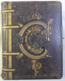 Warrnambool and District Historical Society Inc.
Album - Portrait photos Frisch, Circa 1888
A collection of photographs depicting numerous people. Some have been taken by studios such as Lovewell & Co, Hider, Jordan and Daniel Clarke of Warrnambool. Most of the photos are unnamed but of those that are there is a Thom Wickham, E. M. Fleming, Henry and Stanly Frisch. There are also a number of photographs depicting land clearing and wood cutting also a couple of cards, one happy New year and Glaedelig Jul( Danish Merry Christmas)An album typical of the era with local family connections as well as work by local photographersBrown leather cover with gold figure work over embossing on the front with possibly the letter,”C”. The back cover is entirely embossed. Edges of metal clasp are on front and back cover but clasp part is missing. Gold edges to pages, which are all heavy card. Front inside page has pink briar roses with “Album” on card inserted through it.Jan 17th 1888. To Morris from H Bambrick?warrnambool, warrnambool photographers, lovewell & co, jordan photographers, daniel clarke, thom wickham, e m fleming, henry frisch, stanley frisch -
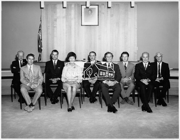 Eltham District Historical Society Inc
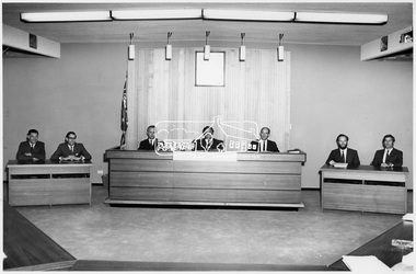
Photograph, Shire of Eltham Council Members at time of Centenary Celebrations, 1971
Shire of Eltham Council Members at time of Centenary Celebrations. Left to Right: Cr. J.V. McConnell (Central), Cr. P. Graham (West), Cr. A. Glover (West), Cr. Mrs. Chariw .M. Pelling (North), Cr. B. Taylor (Central), Cr. G.C. Dreverman (President) (Central), Cr. Les E. Clarke (West), Cr. E.A. Hale (North), Cr. J.O. White (North).This photo forms part of a collection of photographs gathered by the Shire of Eltham for their centenary project book, "Pioneers and Painters: 100 years of the Shire of Eltham" by Alan Marshall (1971). The collection of over 500 images is held in partnership between Eltham District Historical Society and Yarra Plenty Regional Library (Eltham Library) and is now formally known as 'The Shire of Eltham Pioneers Photograph Collection.' It is significant in being the first community sourced collection representing the places and people of the Shire's first one hundred years.Digital imagesepp, shire of eltham pioneers photograph collection, shire of eltham, shire of eltham centenary, council members, cr. a. glover, cr. b. taylor, cr. e.a. hale, cr. g.c. dreverman, cr. j.o. white, cr. j.v. mcconnell, cr. l.e. clarke, cr. mrs. c.m. pelling, cr. p. graham, councilors -
 Eltham District Historical Society Inc
Photograph, View of Council Chamber of Shire of Eltham, 1971
Shire of Eltham Council Members at time of Centenary Celebrations. Left to Right: Cr. J.V. McConnell (Central), Cr. P. Graham (West), Cr. A. Glover (West), Cr. Mrs. Chariw .M. Pelling (North), Cr. B. Taylor (Central), Cr. G.C. Dreverman (President) (Central), Cr. Les E. Clarke (West), Cr. E.A. Hale (North), Cr. J.O. White (North). This photo forms part of a collection of photographs gathered by the Shire of Eltham for their centenary project book, "Pioneers and Painters: 100 years of the Shire of Eltham" by Alan Marshall (1971). The collection of over 500 images is held in partnership between Eltham District Historical Society and Yarra Plenty Regional Library (Eltham Library) and is now formally known as 'The Shire of Eltham Pioneers Photograph Collection.' It is significant in being the first community sourced collection representing the places and people of the Shire's first one hundred years.Digital imagesepp, shire of eltham pioneers photograph collection, shire of eltham, shire of eltham centenary, a.j. roberts, c.j. gaudion, council chambers, cr. g.c. dreverman, g.e. newton, j.a. mcdonald, m.a. verhoeven, m.b. watson, councilors, officers, municipal -
 Stawell Historical Society Inc
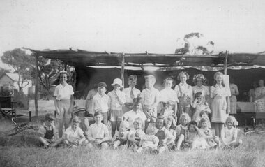
Photograph, Ledcourt School Students in front of shelter
Back 'Left Shirley Walker, Arthur Clarke, Mervyn Launder, Freddy Howard, Bill Cunningham, Lorraine Pickering, Sylvia Launder, Joan Clark, Anne Taylor, May Cunningham(Standing). Front: Stan Pickering, Mervyn Pickering, Dorothy Launder, Alf Taylor, Neville Howard, Cunningham, Beverley Rosenow, Maragret Howard, Ian Howard, ??, Laura Howard, Pauline MOrgan "??' Cunningham, ? < Margaret RallyLadies with tables in background of student and young infants in two lineseducation -
 Ringwood and District Historical Society
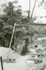
Photographs, 1979-80 MMBW pipe line project at Hubbard Reserve, North Ringwood � Compressor unit in backyard
Part of a 43-photo record of the MMBW�s engineering feat in drilling a 12 inch pipe line up to 40 feet deep through rock hardened by volcanic action associated with geological fault that occurs along the line. The work took place from October 1979 to May 1980 on the southern boundary of Hubbard Reserve, North Ringwood. The collection was presented to the Ringwood Historical Research Group by J Clarke on 9th June 1980.E560 N23 Jan 1980 A43 Compressor unit in backyard of 39 Burlock Avenue -
 Ringwood and District Historical Society
Photographs, 1979-80 MMBW pipe line project at Hubbard Reserve, North Ringwood � Work on boring mole pit
Part of a 43-photo record of the MMBW�s engineering feat in drilling a 12 inch pipe line up to 40 feet deep through rock hardened by volcanic action associated with geological fault that occurs along the line. The work took place from October 1979 to May 1980 on the southern boundary of Hubbard Reserve, North Ringwood. The collection was presented to the Ringwood Historical Research Group by J Clarke on 9th June 1980.E560 N22Jan 1980 A43 Work on mole boring pit in 39 Burlock Avenue backyard -
 Ringwood and District Historical Society
Photographs, 1979-80 MMBW pipe line project at Hubbard Reserve, North Ringwood � Filling at 29 Burlock Avenue
Part of a 43-photo record of the MMBW�s engineering feat in drilling a 12 inch pipe line up to 40 feet deep through rock hardened by volcanic action associated with geological fault that occurs along the line. The work took place from October 1979 to May 1980 on the southern boundary of Hubbard Reserve, North Ringwood. The collection was presented to the Ringwood Historical Research Group by J Clarke on 9th June 1980.E560 N10 Dec 1979 A43 Filling at 29 Burlock Avenue -
 Ringwood and District Historical Society
Photographs, 1979-80 MMBW pipe line project at Hubbard Reserve, North Ringwood � Filling behind 29 Burlock Avenue just off sewer line
Part of a 43-photo record of the MMBW�s engineering feat in drilling a 12 inch pipe line up to 40 feet deep through rock hardened by volcanic action associated with geological fault that occurs along the line. The work took place from October 1979 to May 1980 on the southern boundary of Hubbard Reserve, North Ringwood. The collection was presented to the Ringwood Historical Research Group by J Clarke on 9th June 1980.E560 N9 Dec 1979 A43 Filling behind 29 Burlock Avenue just off sewer line -
 Ringwood and District Historical Society
Photographs, 1979-80 MMBW pipe line project at Hubbard Reserve, North Ringwood � Filling at 29 Burlock Avenue
Part of a 43-photo record of the MMBW�s engineering feat in drilling a 12 inch pipe line up to 40 feet deep through rock hardened by volcanic action associated with geological fault that occurs along the line. The work took place from October 1979 to May 1980 on the southern boundary of Hubbard Reserve, North Ringwood. The collection was presented to the Ringwood Historical Research Group by J Clarke on 9th June 1980.E560 N11 Dec 1979 A43 Filling at 29 Burlock Avenue -
 Ringwood and District Historical Society
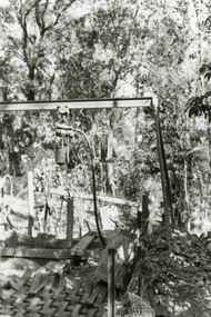
Photographs, 1979-80 MMBW pipe line project at Hubbard Reserve, North Ringwood � Closeup of revolving airwinch near Hibberd's house
Part of a 43-photo record of the MMBW�s engineering feat in drilling a 12 inch pipe line up to 40 feet deep through rock hardened by volcanic action associated with geological fault that occurs along the line. The work took place from October 1979 to May 1980 on the southern boundary of Hubbard Reserve, North Ringwood. The collection was presented to the Ringwood Historical Research Group by J Clarke on 9th June 1980.E560 N31 Jan 1980 A43 Closeup of revolving airwinch near Hibberd's house -
 Ringwood and District Historical Society
Photographs, 1979-80 MMBW pipe line project at Hubbard Reserve, North Ringwood � Grating over hole in Chalkley's 41 Burlock Avenue
Part of a 43-photo record of the MMBW�s engineering feat in drilling a 12 inch pipe line up to 40 feet deep through rock hardened by volcanic action associated with geological fault that occurs along the line. The work took place from October 1979 to May 1980 on the southern boundary of Hubbard Reserve, North Ringwood. The collection was presented to the Ringwood Historical Research Group by J Clarke on 9th June 1980.E560 N25 Jan 1980 A43 Grating over hole 37 feet deep in Chalkley's 41 Burlock Avenue (lot 8) -
 Ringwood and District Historical Society
Photographs, 1979-80 MMBW pipe line project at Hubbard Reserve, North Ringwood � View along line work in Hibberd's and Chalkley's
Part of a 43-photo record of the MMBW�s engineering feat in drilling a 12 inch pipe line up to 40 feet deep through rock hardened by volcanic action associated with geological fault that occurs along the line. The work took place from October 1979 to May 1980 on the southern boundary of Hubbard Reserve, North Ringwood. The collection was presented to the Ringwood Historical Research Group by J Clarke on 9th June 1980.E560 N27 Jan 1980 A43 View along line work in Hibberd's and Chalkley's (lot 9 and 8) -
 Ringwood and District Historical Society
Photographs, 1979-80 MMBW pipe line project at Hubbard Reserve, North Ringwood � Truck-mounted posthole digger that tried to sink shafts on MMBW sewer line behind 29-39 Burlock Avenue
Part of a 43-photo record of the MMBW�s engineering feat in drilling a 12 inch pipe line up to 40 feet deep through rock hardened by volcanic action associated with geological fault that occurs along the line. The work took place from October 1979 to May 1980 on the southern boundary of Hubbard Reserve, North Ringwood. The collection was presented to the Ringwood Historical Research Group by J Clarke on 9th June 1980.E560 N32 Feb 1980 A43 Truck-mounted posthole digger that tried to sink shafts on MMBW sewer line behind 29-39 Burlock Avenue. Four feet wide, the auger could only go down one metre and was nearly useless. -
 Ringwood and District Historical Society
Photographs, 1979-80 MMBW pipe line project at Hubbard Reserve, North Ringwood � View behind no. 39 Burlock Avenue showing compressor, mole pit cover and the big box tree
Part of a 43-photo record of the MMBW�s engineering feat in drilling a 12 inch pipe line up to 40 feet deep through rock hardened by volcanic action associated with geological fault that occurs along the line. The work took place from October 1979 to May 1980 on the southern boundary of Hubbard Reserve, North Ringwood. The collection was presented to the Ringwood Historical Research Group by J Clarke on 9th June 1980.E560 N26 Jan 1980 A43 View behind no. 39 Burlock Avenue showing compressor, mole pit cover and the big box tree -
 Ringwood and District Historical Society
Photographs, 1979-80 MMBW pipe line project at Hubbard Reserve, North Ringwood � Line of sewer work with mole power pack near Hibberd's shed
Part of a 43-photo record of the MMBW�s engineering feat in drilling a 12 inch pipe line up to 40 feet deep through rock hardened by volcanic action associated with geological fault that occurs along the line. The work took place from October 1979 to May 1980 on the southern boundary of Hubbard Reserve, North Ringwood. The collection was presented to the Ringwood Historical Research Group by J Clarke on 9th June 1980.E560 N28 Jan 1980 A43 Line of sewer work with mole power pack near Hibberd's shed -
 Ringwood and District Historical Society
Photographs, 1979-80 MMBW pipe line project at Hubbard Reserve, North Ringwood � View east, sewer work line showing grate over pit
Part of a 43-photo record of the MMBW�s engineering feat in drilling a 12 inch pipe line up to 40 feet deep through rock hardened by volcanic action associated with geological fault that occurs along the line. The work took place from October 1979 to May 1980 on the southern boundary of Hubbard Reserve, North Ringwood. The collection was presented to the Ringwood Historical Research Group by J Clarke on 9th June 1980.E560 N30 Feb 1980 A43 View east, sewer work line showing grate over pit -
 Ringwood and District Historical Society
Photographs, 1979-80 MMBW pipe line project at Hubbard Reserve, North Ringwood � Air winch over the hole in the corner of Chalkley's
Part of a 43-photo record of the MMBW�s engineering feat in drilling a 12 inch pipe line up to 40 feet deep through rock hardened by volcanic action associated with geological fault that occurs along the line. The work took place from October 1979 to May 1980 on the southern boundary of Hubbard Reserve, North Ringwood. The collection was presented to the Ringwood Historical Research Group by J Clarke on 9th June 1980.E561 N1 Feb 1980 A43 Air winch over the hole in the corner of Chalkley's (lot 8) -
 Ringwood and District Historical Society
Photographs, 1979-80 MMBW pipe line project at Hubbard Reserve, North Ringwood � Swivel crane over first hole west of boring pit in 39 Burlock Avenue
Part of a 43-photo record of the MMBW�s engineering feat in drilling a 12 inch pipe line up to 40 feet deep through rock hardened by volcanic action associated with geological fault that occurs along the line. The work took place from October 1979 to May 1980 on the southern boundary of Hubbard Reserve, North Ringwood. The collection was presented to the Ringwood Historical Research Group by J Clarke on 9th June 1980.E561 N3 Feb 1980 A43 Swivel crane over first hole west of boring pit in 39 Burlock Avenue. The track used to reach Burlock Avenue on left. -
 Ringwood and District Historical Society
Photographs, 1979-80 MMBW pipe line project at Hubbard Reserve, North Ringwood � View along MMBW work line in east end of Hibberd's, showing grating over mole boring pit
Part of a 43-photo record of the MMBW�s engineering feat in drilling a 12 inch pipe line up to 40 feet deep through rock hardened by volcanic action associated with geological fault that occurs along the line. The work took place from October 1979 to May 1980 on the southern boundary of Hubbard Reserve, North Ringwood. The collection was presented to the Ringwood Historical Research Group by J Clarke on 9th June 1980.E560 N29 Feb 1980 A43 View along MMBW work line in east end of Hibberd's, showing grating over mole boring pit -
 Ringwood and District Historical Society
Photographs, 1979-80 MMBW pipe line project at Hubbard Reserve, North Ringwood � First hole in Lot 8
Part of a 43-photo record of the MMBW�s engineering feat in drilling a 12 inch pipe line up to 40 feet deep through rock hardened by volcanic action associated with geological fault that occurs along the line. The work took place from October 1979 to May 1980 on the southern boundary of Hubbard Reserve, North Ringwood. The collection was presented to the Ringwood Historical Research Group by J Clarke on 9th June 1980.E561 N2 Feb 1980 A43 Final hole in lot 8 (no. 41) at the corner of Chalkly's -
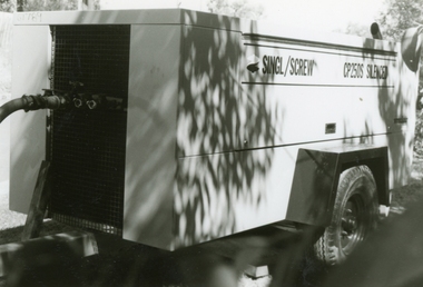 Ringwood and District Historical Society
Photographs, 1979-80 MMBW pipe line project at Hubbard Reserve, North Ringwood � compressor
Part of a 43-photo record of the MMBW�s engineering feat in drilling a 12 inch pipe line up to 40 feet deep through rock hardened by volcanic action associated with geological fault that occurs along the line. The work took place from October 1979 to May 1980 on the southern boundary of Hubbard Reserve, North Ringwood. The collection was presented to the Ringwood Historical Research Group by J Clarke on 9th June 1980.E561 N6 Feb 1980 A43 Compressor of the tunnelling gang on the sewer line in Burlock Ave