Showing 1034 items
matching drill
-
 Merri-bek City Council
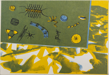
Work on paper - Screen print, Wendy Black, Declare Antarctica a World Park - Phytoplankton, 1982
The 1980s saw a rise in campaigns for Antarctica to be designated a World Park. Black’s screenprints celebrate the creatures of the continent, however invocations such as ‘protect Antarctica from all mineral and oil exploration and exploitation’ remind the viewer that these creatures are in peril. Black printed 500 of these postcards (described as ‘Antarcticards’) at the Redletter Press in Brunswick and they were distributed around the world, reaching as far as Macquarie and Heard Islands. The campaigning was successful, with Australian Prime Minister Bob Hawke announcing that Australia would not support an agreement that would open the Australian Antarctic Territory up to mining and oil drilling.Donated by the artist8 prints in total -
 Merri-bek City Council
Work on paper - Screen print, Wendy Black, Declare Antarctica a World Park - Squid (1982), 1982
The 1980s saw a rise in campaigns for Antarctica to be designated a World Park. Black’s screenprints celebrate the creatures of the continent, however invocations such as ‘protect Antarctica from all mineral and oil exploration and exploitation’ remind the viewer that these creatures are in peril. Black printed 500 of these postcards (described as ‘Antarcticards’) at the Redletter Press in Brunswick and they were distributed around the world, reaching as far as Macquarie and Heard Islands. The campaigning was successful, with Australian Prime Minister Bob Hawke announcing that Australia would not support an agreement that would open the Australian Antarctic Territory up to mining and oil drilling.Donated by the artist8 prints in total -
 Merri-bek City Council
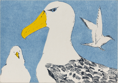
Work on paper - Screen print, Wendy Black, Declare Antarctica a World Park - Tern, 1982
The 1980s saw a rise in campaigns for Antarctica to be designated a World Park. Black’s screenprints celebrate the creatures of the continent, however invocations such as ‘protect Antarctica from all mineral and oil exploration and exploitation’ remind the viewer that these creatures are in peril. Black printed 500 of these postcards (described as ‘Antarcticards’) at the Redletter Press in Brunswick and they were distributed around the world, reaching as far as Macquarie and Heard Islands. The campaigning was successful, with Australian Prime Minister Bob Hawke announcing that Australia would not support an agreement that would open the Australian Antarctic Territory up to mining and oil drilling.Donated by the artist8 prints in total -
 Merri-bek City Council
Work on paper - Screen print, Wendy Black, Declare Antarctica a World Park - Whale, 1982
The 1980s saw a rise in campaigns for Antarctica to be designated a World Park. Black’s screenprints celebrate the creatures of the continent, however invocations such as ‘protect Antarctica from all mineral and oil exploration and exploitation’ remind the viewer that these creatures are in peril. Black printed 500 of these postcards (described as ‘Antarcticards’) at the Redletter Press in Brunswick and they were distributed around the world, reaching as far as Macquarie and Heard Islands. The campaigning was successful, with Australian Prime Minister Bob Hawke announcing that Australia would not support an agreement that would open the Australian Antarctic Territory up to mining and oil drilling.Donated by the artist8 prints in total -
 Merri-bek City Council
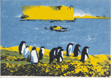
Work on paper - Screen print, Wendy Black, Declare Antarctica a World Park - Penguin, 1982
The 1980s saw a rise in campaigns for Antarctica to be designated a World Park. Black’s screenprints celebrate the creatures of the continent, however invocations such as ‘protect Antarctica from all mineral and oil exploration and exploitation’ remind the viewer that these creatures are in peril. Black printed 500 of these postcards (described as ‘Antarcticards’) at the Redletter Press in Brunswick and they were distributed around the world, reaching as far as Macquarie and Heard Islands. The campaigning was successful, with Australian Prime Minister Bob Hawke announcing that Australia would not support an agreement that would open the Australian Antarctic Territory up to mining and oil drilling.Donated by the artist8 prints in total -
 Merri-bek City Council
Work on paper - Screen print, Wendy Black, Declare Antarctica a World Park - Adelie, 1982
The 1980s saw a rise in campaigns for Antarctica to be designated a World Park. Black’s screenprints celebrate the creatures of the continent, however invocations such as ‘protect Antarctica from all mineral and oil exploration and exploitation’ remind the viewer that these creatures are in peril. Black printed 500 of these postcards (described as ‘Antarcticards’) at the Redletter Press in Brunswick and they were distributed around the world, reaching as far as Macquarie and Heard Islands. The campaigning was successful, with Australian Prime Minister Bob Hawke announcing that Australia would not support an agreement that would open the Australian Antarctic Territory up to mining and oil drilling.Donated by the artist8 prints in total -
 Bendigo Military Museum
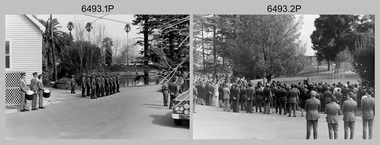
Photograph - Military Funeral for SSGT Peter Dew, Army Survey Regiment, Fortuna, Bendigo, 1977
This is a set of 29 black & white photographs of troops from the Army Headquarters Survey Regiment undertaking ceremonial drill at the military funeral for SSGT Peter Dew on the 28th of September 1977. The location of the funeral service was at Fortuna, Bendigo. He was buried at Bendigo Cemetery in Quarry Hill. Peter Dew died in a tragic accident at home. He was fondly remembered as one of Lithographic Squadron’s colourful personalities. See item 6243.7P for photos of Peter Dew at work in Lithographic Squadron. The "Super Animal of the Year" Peter Dew Memorial Award was an award presented to a member of the squadron for a crude act. To view a photo of this award, refer to item 6230 of the Victorian Collections. Some photos in this set were also printed on photo paper and catalogued under item 6335.5P.This is a set of 29 black & white photographs of troops from the Army Headquarters Survey Regiment undertaking ceremonial drill at the military funeral for SSGT Peter held in 1977. The photographs are on 35mm negative film and scanned at 96 dpi. They are part of the Army Survey Regiment’s Collection. .1) - Photo, black & white, 1977. Rifle party commander: CPL Greg Kidman. Right file right marker: SPR Russ Mollenhauer, unidentified soldiers and civilians. .2) - Photo, black & white, 1977. Unidentified soldiers and civilians. .3) - Photo, black & white, 1977. R to L: SSGT Alan Adsett, WO2 John McCulloch, SGT Graeme Jeffers in foreground holding hats. Remainder unidentified. .4) to .6) - Photo, black & white, 1977. Unidentified soldiers and civilians. R to L: SSGT Alan Adsett, WO2 John McCulloch, unidentified soldiers and civilians. .7) - Photo, black & white, 1977. Pall bearers position the coffin onto the gun carriage. Rifle party commander: CPL Greg Kidman. Right file right marker: SPR Russ Mollenhauer. Seen in background to the right of pall bearers: L to R: CPL Ian Belmont, unidentified, facing away- PTE Le-anne (Smallshaw) Shirley, CPL Di Chalmers, unidentified soldiers and civilians. .8) - Photo, black & white, 1977. Rifle party rear rank right marker: Russ Mollenhauer. Front rank rifle party commander next to right marker: Greg Kidman. Pall bearers in front of vehicle L to R: Dave Miles, Dick Barwald. Remainder unidentified. .9) - Photo, black & white, 1977. In position at beginning of funeral procession, unidentified soldiers and civilians. .10) & .11) - Photo, black & white, 1977. Rifle party commander: CPL Greg Kidman and the rifle party slow march past the front of Fortuna Villa. .12) - Photo, black & white, 1977. The rifle party slow march past the front of Fortuna Villa. Rifle party commander: Greg Kidman. Right file front to back: SPR Russ Mollenhauer, SPR Peter Breukel, SPR Bill Jones, SPR John Anderson. Remainder unidentified. Left file front to back: SPR Jeff Willey, unidentified, SPR Rhys De Laine, SPR Frank Lenane, SPR Josh Degroot, SPR Gary Drummond. .13) - Photo, black & white, 1977. The rifle party slow march past the front of Fortuna Villa. Rifle party commander: Greg Kidman. Right file: SPR Russ Mollenhauer, Left file: SPR Jeff Willey, remainder unidentified. .14) - Photo, black & white, 1977. The rifle party march at quick time towards the entry gate. .15) - Photo, black & white, 1977. The rifle party march at quick time past the front of Fortuna Villa. Rifle party commander: Greg Kidman. Right file: SPR Russ Mollenhauer, Left file: SPR Jeff Willey, remainder unidentified. .16) - Photo, black & white, 1977. The procession marches at quick time towards the entry gate. .17) - Photo, black & white, 1977. The procession departs the entry gate. .18) to .21)- Photo, black & white, 1977. The procession passes through the cemetery. .22) - Photo, black & white, 1977. The procession passes through the cemetery. RSM Wo1 Aub Harvey at far left. Remainder unidentified. .23) - Photo, black & white, 1977. Pallbearers carry Peter Dew’s coffin to the grave site. .24) - Photo, black & white, 1977. The rifle party in position at ‘rest on arms reverse’. .25) - Photo, black & white, 1977. Service at grave site. Left of minister: SGT Alan Toogood. On right of tree L to R: WO2 Max Neil, WO2 Bob Hayden, WO1 Dave Malligan, PTE Le-Anne (Smallshaw) Shirley, CAPT Stan Vote. Remainder unidentified. .26) - Photo, black & white, 1977. The rifle party fire volleys. .27) - Photo, black & white, 1977. The rifle party presents arms. .28) - Photo, black & white, 1977. Service at grave site. SGT Greg Francis-Wright 4th from right. .29) - Photo, black & white, 1977. Outside Litho’s proofing hut at Fortuna. WO1 Darby Munro stands in contemplation next to the collection of flowers.There are no personnel identified. royal australian survey corps, rasvy, army survey regiment, army svy regt, fortuna, asr, litho sqn -
 Kiewa Valley Historical Society
Photograph - Folder of Photographs (KVHS 1150 A - F) – Photocopied set of black and white photographs from the display folder (pages 1 - 8) put together by KVHS to document life on the Kiewa Valley Hydro-electric Scheme
Although the Kiewa Hydro-Electric Scheme was first proposed in 1911, construction did not commence until 1938. As part of the push to cut electricity costs and diversify supply, the Victorian Government (circa 1930) initiated the conversion from primarily brown coal supply to hydro – electricity. Field investigations during the 1940’s resulted in a new proposal for a scheme that had more than double the capacity of the 1938 scheme. The Kiewa Hydroelectric Scheme became the largest scheme of its kind in the State Of Victoria and the second largest scheme in Australia. The number of personnel involved in the planning and construction of the scheme increased dramatically. During the late 1940’s, most activity centred around the construction of the West Kiewa Power Station, Rocky Valley Reservoir, McKay Creek Power Station and the Bogong Creek Aqueduct.A common thread across all the larger hydro scheme constructions was the need for workers, both qualified and unqualified who came from around the world seeking a new life for themselves and their families. New accommodation and facilities were required for the army of workers engaged in construction in often remote and wild areas. The SEC had a high demand for timber, and set up the first of a number of sawmills at Bogong Creek in 1939 and set up the first hardwood logging in the headwaters of the Kiewa River. These new ‘towns’ such as Mt Beauty and Bogong, survived, serving the needs of operational personnel and their families, and expanding with growth of new industries. Mount Beauty, and to a lesser extent Bogong, are among these places. Large A3 size spiral bound display folder containing 21 of 58 pages of photocopied black and white photographs of various aspects of the early days of the Kiewa Valley Hydro-electric scheme including equipment, various work sites and photographs of workers and their families. 1-Front page; 2-Security gate at Mt Beauty Camp; 3-Channel 1 on East Kiewa River; 4-Junction Dam – Diversion Tunnel Inlet; 5-Sawmill; 6- Homan’s Gap Sawmill; 7 Junction Dam: 8-Homan Dam Site-Diamond Drilling on River Buttress; 9- Homan Dam Site View Upstream 10-Homan Dam Investigation Camp 1-Windsor & Newton Visual Diary 60 sheet (120 pages) 11’ x 14’ 280 x 356mm 110 GSM Acid Free Drawing Paper 2-1940-Security Gate on Mt Beauty side of Kiewa River bridge. Part of old Mt Beauty camp and mess in background 3- STATE ELECTRICITY COMMISSION OF VICTORIA Date; 11.3.40 Time: 10.30am No K35 Kiewa Hydro Electric Works. Diverting East Kiewa River into Channel Page number 1 4-STATE ELECTRICITY COMMISSION OF VICTORIA Date: 5.4.40 Time: Noon No K58 Kiewa Hydro Electric Works. Junction Dam – Diversion Tunnel Inlet – Normal Flow Page number 2 5- STATE ELECTRICITY COMMISSION OF VICTORIA Date: 19.8.42 Time: 2.30pm No K883 Kiewa Hydro Electric Works. Sawmill – General View Page number 3 6- STATE ELECTRICITY COMMISSION OF VICTORIA Date: 12.1.42 Time: 2.00pm No K540 Kiewa Hydro Electric Works. Homan’s Gap Sawmill – General View Page number 4 7- STATE ELECTRICITY COMMISSION OF VICTORIA Date: 12.1.42 Time: 2.00pm No K540 Kiewa Hydro Electric Works. Junction Dam – General View looking upstream Page number 5 8- STATE ELECTRICITY COMMISSION OF VICTORIA Date: 16.11.45 Time: 10.32amm No K52153 Kiewa Hydro Electric Works Homan Dam Site – Diamond Drilling on River Buttress Page number 6 9-STATE ELECTRICITY COMMISSION OF VICTORIA Date: 15.1.45 Time: 4.10pm No K1781 Kiewa Hydro Electric Works Homan Dam Site – View Upstream Page number 7 10- STATE ELECTRICITY COMMISSION OF VICTORIA Date: 15.1.45 Time: 4.10pm No K1781 Kiewa Hydro Electric Works Homan Dam Investigation Camp 1944 – 1945 Page number 8 secv; kiewa hydro electric scheme; mt beauty; bogong; construction work; -
 Ringwood and District Historical Society
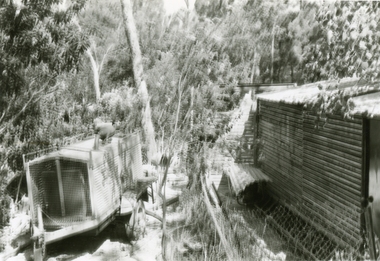
Photographs, 1979-80 MMBW pipe line project at Hubbard Reserve, North Ringwood � Compressor unit in backyard
Part of a 43-photo record of the MMBW�s engineering feat in drilling a 12 inch pipe line up to 40 feet deep through rock hardened by volcanic action associated with geological fault that occurs along the line. The work took place from October 1979 to May 1980 on the southern boundary of Hubbard Reserve, North Ringwood. The collection was presented to the Ringwood Historical Research Group by J Clarke on 9th June 1980.E560 N23 Jan 1980 A43 Compressor unit in backyard of 39 Burlock Avenue -
 Ringwood and District Historical Society
Photographs, 1979-80 MMBW pipe line project at Hubbard Reserve, North Ringwood � Work on boring mole pit
Part of a 43-photo record of the MMBW�s engineering feat in drilling a 12 inch pipe line up to 40 feet deep through rock hardened by volcanic action associated with geological fault that occurs along the line. The work took place from October 1979 to May 1980 on the southern boundary of Hubbard Reserve, North Ringwood. The collection was presented to the Ringwood Historical Research Group by J Clarke on 9th June 1980.E560 N22Jan 1980 A43 Work on mole boring pit in 39 Burlock Avenue backyard -
 Ringwood and District Historical Society
Photographs, 1979-80 MMBW pipe line project at Hubbard Reserve, North Ringwood � Filling at 29 Burlock Avenue
Part of a 43-photo record of the MMBW�s engineering feat in drilling a 12 inch pipe line up to 40 feet deep through rock hardened by volcanic action associated with geological fault that occurs along the line. The work took place from October 1979 to May 1980 on the southern boundary of Hubbard Reserve, North Ringwood. The collection was presented to the Ringwood Historical Research Group by J Clarke on 9th June 1980.E560 N10 Dec 1979 A43 Filling at 29 Burlock Avenue -
 Ringwood and District Historical Society
Photographs, 1979-80 MMBW pipe line project at Hubbard Reserve, North Ringwood � Filling behind 29 Burlock Avenue just off sewer line
Part of a 43-photo record of the MMBW�s engineering feat in drilling a 12 inch pipe line up to 40 feet deep through rock hardened by volcanic action associated with geological fault that occurs along the line. The work took place from October 1979 to May 1980 on the southern boundary of Hubbard Reserve, North Ringwood. The collection was presented to the Ringwood Historical Research Group by J Clarke on 9th June 1980.E560 N9 Dec 1979 A43 Filling behind 29 Burlock Avenue just off sewer line -
 Ringwood and District Historical Society
Photographs, 1979-80 MMBW pipe line project at Hubbard Reserve, North Ringwood � Filling at 29 Burlock Avenue
Part of a 43-photo record of the MMBW�s engineering feat in drilling a 12 inch pipe line up to 40 feet deep through rock hardened by volcanic action associated with geological fault that occurs along the line. The work took place from October 1979 to May 1980 on the southern boundary of Hubbard Reserve, North Ringwood. The collection was presented to the Ringwood Historical Research Group by J Clarke on 9th June 1980.E560 N11 Dec 1979 A43 Filling at 29 Burlock Avenue -
 Ringwood and District Historical Society
Photographs, 1979-80 MMBW pipe line project at Hubbard Reserve, North Ringwood � Closeup of revolving airwinch near Hibberd's house
Part of a 43-photo record of the MMBW�s engineering feat in drilling a 12 inch pipe line up to 40 feet deep through rock hardened by volcanic action associated with geological fault that occurs along the line. The work took place from October 1979 to May 1980 on the southern boundary of Hubbard Reserve, North Ringwood. The collection was presented to the Ringwood Historical Research Group by J Clarke on 9th June 1980.E560 N31 Jan 1980 A43 Closeup of revolving airwinch near Hibberd's house -
 Ringwood and District Historical Society
Photographs, 1979-80 MMBW pipe line project at Hubbard Reserve, North Ringwood � Grating over hole in Chalkley's 41 Burlock Avenue
Part of a 43-photo record of the MMBW�s engineering feat in drilling a 12 inch pipe line up to 40 feet deep through rock hardened by volcanic action associated with geological fault that occurs along the line. The work took place from October 1979 to May 1980 on the southern boundary of Hubbard Reserve, North Ringwood. The collection was presented to the Ringwood Historical Research Group by J Clarke on 9th June 1980.E560 N25 Jan 1980 A43 Grating over hole 37 feet deep in Chalkley's 41 Burlock Avenue (lot 8) -
 Ringwood and District Historical Society
Photographs, 1979-80 MMBW pipe line project at Hubbard Reserve, North Ringwood � View along line work in Hibberd's and Chalkley's
Part of a 43-photo record of the MMBW�s engineering feat in drilling a 12 inch pipe line up to 40 feet deep through rock hardened by volcanic action associated with geological fault that occurs along the line. The work took place from October 1979 to May 1980 on the southern boundary of Hubbard Reserve, North Ringwood. The collection was presented to the Ringwood Historical Research Group by J Clarke on 9th June 1980.E560 N27 Jan 1980 A43 View along line work in Hibberd's and Chalkley's (lot 9 and 8) -
 Ringwood and District Historical Society
Photographs, 1979-80 MMBW pipe line project at Hubbard Reserve, North Ringwood � Truck-mounted posthole digger that tried to sink shafts on MMBW sewer line behind 29-39 Burlock Avenue
Part of a 43-photo record of the MMBW�s engineering feat in drilling a 12 inch pipe line up to 40 feet deep through rock hardened by volcanic action associated with geological fault that occurs along the line. The work took place from October 1979 to May 1980 on the southern boundary of Hubbard Reserve, North Ringwood. The collection was presented to the Ringwood Historical Research Group by J Clarke on 9th June 1980.E560 N32 Feb 1980 A43 Truck-mounted posthole digger that tried to sink shafts on MMBW sewer line behind 29-39 Burlock Avenue. Four feet wide, the auger could only go down one metre and was nearly useless. -
 Ringwood and District Historical Society
Photographs, 1979-80 MMBW pipe line project at Hubbard Reserve, North Ringwood � View behind no. 39 Burlock Avenue showing compressor, mole pit cover and the big box tree
Part of a 43-photo record of the MMBW�s engineering feat in drilling a 12 inch pipe line up to 40 feet deep through rock hardened by volcanic action associated with geological fault that occurs along the line. The work took place from October 1979 to May 1980 on the southern boundary of Hubbard Reserve, North Ringwood. The collection was presented to the Ringwood Historical Research Group by J Clarke on 9th June 1980.E560 N26 Jan 1980 A43 View behind no. 39 Burlock Avenue showing compressor, mole pit cover and the big box tree -
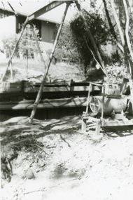
 Ringwood and District Historical Society
Photographs, 1979-80 MMBW pipe line project at Hubbard Reserve, North Ringwood � Line of sewer work with mole power pack near Hibberd's shed
Part of a 43-photo record of the MMBW�s engineering feat in drilling a 12 inch pipe line up to 40 feet deep through rock hardened by volcanic action associated with geological fault that occurs along the line. The work took place from October 1979 to May 1980 on the southern boundary of Hubbard Reserve, North Ringwood. The collection was presented to the Ringwood Historical Research Group by J Clarke on 9th June 1980.E560 N28 Jan 1980 A43 Line of sewer work with mole power pack near Hibberd's shed -
 Ringwood and District Historical Society
Photographs, 1979-80 MMBW pipe line project at Hubbard Reserve, North Ringwood � View east, sewer work line showing grate over pit
Part of a 43-photo record of the MMBW�s engineering feat in drilling a 12 inch pipe line up to 40 feet deep through rock hardened by volcanic action associated with geological fault that occurs along the line. The work took place from October 1979 to May 1980 on the southern boundary of Hubbard Reserve, North Ringwood. The collection was presented to the Ringwood Historical Research Group by J Clarke on 9th June 1980.E560 N30 Feb 1980 A43 View east, sewer work line showing grate over pit -
 Ringwood and District Historical Society
Photographs, 1979-80 MMBW pipe line project at Hubbard Reserve, North Ringwood � Air winch over the hole in the corner of Chalkley's
Part of a 43-photo record of the MMBW�s engineering feat in drilling a 12 inch pipe line up to 40 feet deep through rock hardened by volcanic action associated with geological fault that occurs along the line. The work took place from October 1979 to May 1980 on the southern boundary of Hubbard Reserve, North Ringwood. The collection was presented to the Ringwood Historical Research Group by J Clarke on 9th June 1980.E561 N1 Feb 1980 A43 Air winch over the hole in the corner of Chalkley's (lot 8) -
 Ringwood and District Historical Society
Photographs, 1979-80 MMBW pipe line project at Hubbard Reserve, North Ringwood � Swivel crane over first hole west of boring pit in 39 Burlock Avenue
Part of a 43-photo record of the MMBW�s engineering feat in drilling a 12 inch pipe line up to 40 feet deep through rock hardened by volcanic action associated with geological fault that occurs along the line. The work took place from October 1979 to May 1980 on the southern boundary of Hubbard Reserve, North Ringwood. The collection was presented to the Ringwood Historical Research Group by J Clarke on 9th June 1980.E561 N3 Feb 1980 A43 Swivel crane over first hole west of boring pit in 39 Burlock Avenue. The track used to reach Burlock Avenue on left. -
 Ringwood and District Historical Society
Photographs, 1979-80 MMBW pipe line project at Hubbard Reserve, North Ringwood � View along MMBW work line in east end of Hibberd's, showing grating over mole boring pit
Part of a 43-photo record of the MMBW�s engineering feat in drilling a 12 inch pipe line up to 40 feet deep through rock hardened by volcanic action associated with geological fault that occurs along the line. The work took place from October 1979 to May 1980 on the southern boundary of Hubbard Reserve, North Ringwood. The collection was presented to the Ringwood Historical Research Group by J Clarke on 9th June 1980.E560 N29 Feb 1980 A43 View along MMBW work line in east end of Hibberd's, showing grating over mole boring pit -
 Ringwood and District Historical Society
Photographs, 1979-80 MMBW pipe line project at Hubbard Reserve, North Ringwood � First hole in Lot 8
Part of a 43-photo record of the MMBW�s engineering feat in drilling a 12 inch pipe line up to 40 feet deep through rock hardened by volcanic action associated with geological fault that occurs along the line. The work took place from October 1979 to May 1980 on the southern boundary of Hubbard Reserve, North Ringwood. The collection was presented to the Ringwood Historical Research Group by J Clarke on 9th June 1980.E561 N2 Feb 1980 A43 Final hole in lot 8 (no. 41) at the corner of Chalkly's -
 Ringwood and District Historical Society
Photographs, 1979-80 MMBW pipe line project at Hubbard Reserve, North Ringwood � Boring hole in lot 7
Part of a 43-photo record of the MMBW�s engineering feat in drilling a 12 inch pipe line up to 40 feet deep through rock hardened by volcanic action associated with geological fault that occurs along the line. The work took place from October 1979 to May 1980 on the southern boundary of Hubbard Reserve, North Ringwood. The collection was presented to the Ringwood Historical Research Group by J Clarke on 9th June 1980.E561 N4 Feb 1980 A43 The boring hole, 39' deep, at lot 7 (Clarke's, 39 Burlock Ave) with the generator used to supply light. -
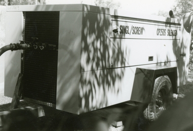 Ringwood and District Historical Society
Photographs, 1979-80 MMBW pipe line project at Hubbard Reserve, North Ringwood � compressor
Part of a 43-photo record of the MMBW�s engineering feat in drilling a 12 inch pipe line up to 40 feet deep through rock hardened by volcanic action associated with geological fault that occurs along the line. The work took place from October 1979 to May 1980 on the southern boundary of Hubbard Reserve, North Ringwood. The collection was presented to the Ringwood Historical Research Group by J Clarke on 9th June 1980.E561 N6 Feb 1980 A43 Compressor of the tunnelling gang on the sewer line in Burlock Ave -
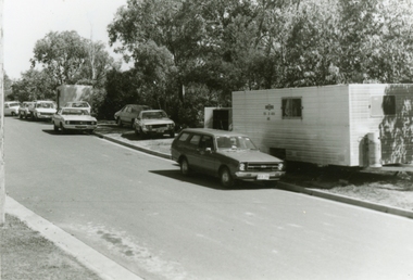 Ringwood and District Historical Society
Photographs, 1979-80 MMBW pipe line project at Hubbard Reserve, North Ringwood � cars and caravan of gang
Part of a 43-photo record of the MMBW�s engineering feat in drilling a 12 inch pipe line up to 40 feet deep through rock hardened by volcanic action associated with geological fault that occurs along the line. The work took place from October 1979 to May 1980 on the southern boundary of Hubbard Reserve, North Ringwood. The collection was presented to the Ringwood Historical Research Group by J Clarke on 9th June 1980.E561 N5 Feb 1980 A43 Cars and caravans of the tunnelling gang in Burlock Ave -
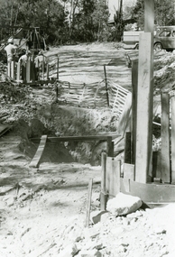 Ringwood and District Historical Society
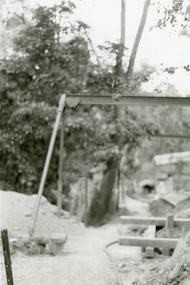
Photographs, 1979-80 MMBW pipe line project at Hubbard Reserve, North Ringwood
Part of a 43-photo record of the MMBW engineering feat in drilling a 12 inch pipe line up to 40 feet deep through rock hardened by volcanic action associated with geological fault that occurs along the line. The work took place from October 1979 to May 1980 on the southern boundary of Hubbard Reserve, North Ringwood. The collection was presented to the Ringwood Historical Research Group by J Clarke on 9th June 1980."E565 N8 16 April 1980 A43 The pipe laying has been finished, now to cover it all in." -
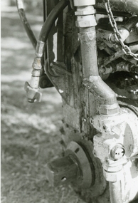 Ringwood and District Historical Society
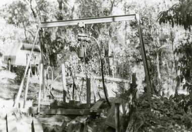
Photographs, 1979-80 MMBW pipe line project at Hubbard Reserve, North Ringwood � The grip of the mole
Part of a 43-photo record of the MMBW�s engineering feat in drilling a 12 inch pipe line up to 40 feet deep through rock hardened by volcanic action associated with geological fault that occurs along the line. The work took place from October 1979 to May 1980 on the southern boundary of Hubbard Reserve, North Ringwood. The collection was presented to the Ringwood Historical Research Group by J Clarke on 9th June 1980.E565 N11 28 April 1980 A43 The grip of the mechanical mole. The square at the bottom revolves, turning the sectioned shaft that carries the mole at its end. -
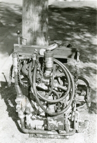 Ringwood and District Historical Society
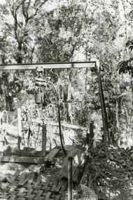
Photographs, 1979-80 MMBW pipe line project at Hubbard Reserve, North Ringwood � hydraulic mole
Part of a 43-photo record of the MMBW�s engineering feat in drilling a 12 inch pipe line up to 40 feet deep through rock hardened by volcanic action associated with geological fault that occurs along the line. The work took place from October 1979 to May 1980 on the southern boundary of Hubbard Reserve, North Ringwood. The collection was presented to the Ringwood Historical Research Group by J Clarke on 9th June 1980.E565 N10 28 April 1980 A43 The "muscles" of the mechanical mole, driven by a hydraulic line from a powerful "power pack".