Showing 3720 items matching "landscape"
-
 Bendigo Historical Society Inc.
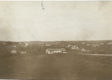
Photograph - ROBERT DENIS KELLY COLLECTION: LANDSCAPE
Black and white photo: landscape view of Biesmes.person, robert denis kelly, world war 1, france, biesmes -
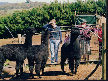
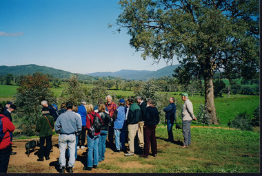 Wooragee Landcare Group
Photograph, 5 September 2004
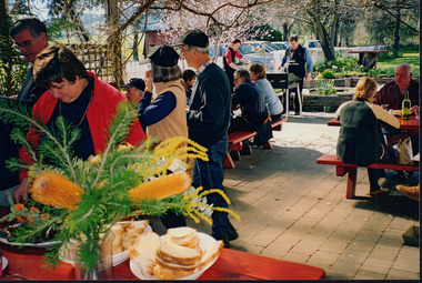
This photograph was taken at Samaria Farm on Sunday the 5th of September as part of a day trip by the Wooragee Landcare Group. The event was about looking at land use on small farms and as a social get-together for the Group. Wooragee Landcare was also researching how small landholders could run some enterprises around the time of this trip. Samaria Farm is located in northeast Victoria, near Mount Samaria, which is located 130 km northeast of Melbourne. Samaria Farm was owned by Sue and Due Matheson at the time of the trip and had a renowned rose garden, pigs, poultry, alpacas, and goats on their nine-hectare farm. The rose garden consists of 3000 damask roses. Samaria Farm distils the oil from these roses and is the only farm in Australia to do this. Rose oil has historically been used for religious and medical use. 20 kg of rose buds are picked by hand every day, which is then distilled and produced 5 to 8 ml of oil. The entire four-week season produces 80 to 100 ml of oil. Rose water is also created during this process and produces about 300 litres per season. Along with the oil, the Farm also harvests lemons, lime, olives, and oranges. The Farm is currently owned by Utako and Anthony since 2022, with Vicki and Allan Wight being the previous owners. Wooragee Landcare Group was created in 1988. Its core mission is to work towards eradicating animals and pests from the land to protect the natural vegetation and promote revegetation projects. This photograph is a great example of the type of events that Wooragee Landcare Group has organized, while educating the public about the importance of land use management. The group is important to the community and for the environment.Landscape coloured photograph printed on gloss paperReverse: WAN NA E0NA2N2. NNN+ 2 4240/ [PRINTED] (No. 18) / 371samaria farm, wooragee, wooragee landcare group, wooragee landcare's collection, samaria, small farm, land use, social, rose oil, damask roses, pests -
 Wooragee Landcare Group
Photograph, 5 September 2004
This photograph was taken at Samaria Farm on Sunday the 5th of September as part of a day trip by the Wooragee Landcare Group. The event was about looking at land use on small farms and as a social get-together for the Group. Wooragee Landcare was also researching how small landholders could run some enterprises around the time of this trip. Samaria Farm is located in northeast Victoria, near Mount Samaria, which is located 130 km northeast of Melbourne. Samaria Farm was owned by Sue and Due Matheson at the time of the trip and had a renowned rose garden, pigs, poultry, alpacas, and goats on their nine-hectare farm. The rose garden consists of 3000 damask roses. Samaria Farm distils the oil from these roses and is the only farm in Australia to do this. Rose oil has historically been used for religious and medical use. 20 kg of rose buds are picked by hand every day, which is then distilled and produced 5 to 8 ml of oil. The entire four-week season produces 80 to 100 ml of oil. Rose water is also created during this process and produces about 300 litres per season. Along with the oil, the Farm also harvests lemons, lime, olives, and oranges. The Farm is currently owned by Utako and Anthony since 2022, with Vicki and Allan Wight being the previous owners. Wooragee Landcare Group was created in 1988. Its core mission is to work towards eradicating animals and pests from the land to protect the natural vegetation and promote revegetation projects. This photograph is a great example of the type of events that Wooragee Landcare Group has organized, while educating the public about the importance of land use management. The group is important to the community and for the environment. Landscape colored photograph printed on gloss paperReverse: WAN NA E0NA2N2. ANN+ 1 4240/ [PRINTED] (No. 19) / 372samaria farm, wooragee landcare group, wooragee, victoria, mount samaria, farming, roses, rose oil, damask roses, agriculture, pests, vegetation -
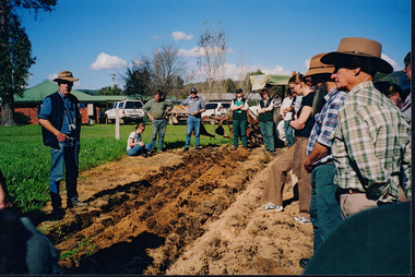
 Wooragee Landcare Group
Photograph, 27 August 2004
This photograph was taken on Friday the 27th of August 2004 as part of an event called 'Direct Seeding Expo'. This event was one of many held by the Wooragee Landcare Group in the early 2000s which aimed to educate the local community on certain agricultural and biodiversity conservative techniques. This particular event took place across three different locations - Wooragee Hall, and direct seeded sites at the properties of Marcus and Lisa O'Connor, and Neil and Anne Nankervis - and, therefore, the exact location where this photograph was taken is unknown. Three different direct seeding techniques were demonstrated during the day by several experts in the field. Direct seeding involves the sowing of seeds directly into the soil to achieve germination and establishment. It is an alternative to planting seedlings in a contained nursery plot. This direct method is intended to mimic a more natural process of growth, revegetating larger areas in a more efficient manner. This photograph is significant as it provides evidence of a project undertaken by the Wooragee Landcare Group in the early 2000s to educate members of the public on alternative and potentially more efficient methods of planting seedlings. The Wooragee Landcare Group has been instrumental in the co-ordination of programs relating to biodiversity protection in the local area, providing great assistance to landholders.Landscape coloured photograph printed on gloss paperReverse: WAN NA EOWA2N2 ANN- 1 4240 / neil and anne nankervis, marcus and lisa o'connor, wooragee hall, wooragee landcare, wooragee landcare group, direct seeding expo, direct seeding, seeds, revegetation, alternative planting -
 Wooragee Landcare Group
Photograph, 5 September 2004
This photograph was taken at Tatong Tavern, Victoria on Sunday the 5th of September as part of a day trip by the Wooragee Landcare Group. The event was about looking at land use on small farms and as a social get-together for the Group. Wooragee was also researching how small landholders could run some enterprises around the time of the trip. This photograph includes Jo Luisi, Bob Bennet, Christine Stewart, and Julius Holt. Tatong Tavern was built in the 1880's as Tatong Hotel or 'Pub' hotel for Mr. William Worrall. The original hotel was destroyed in 1923 by a fire, but was rebuilt for Mr. M. C. Clarke. The building is a representation of the changing society, as it changes as its uses and visitors change. The photograph shows the beer garden, which has been added more recently. The Tavern has a bar, restaurant, and accommodation area. Wooragee Landcare Group was created in 1988. Its core mission is to work towards eradicating animals and pests from the land to protect the natural vegetation and promote revegetation projects.This photograph is a great example of the type of events that Wooragee Landcare Group has organized, while educating the public about the importance of land use management. It showcases the social aspect of the Group, as well as the historic Tatong Tavern. Landscape colored photograph printed on gloss paper. Reverse: WAN NA E0NA2N2. NNN+ 1 4240/ [PRINTED] (No. 22) / 375wooragee, wooragee landcare group, wooragee landcare's collection, land use, social, tatong tavern, tatong hotel, tatong pub -
 Wooragee Landcare Group
Photograph, 5 September 2004
This photograph was taken at Tatong Tavern, Victoria on Sunday the 5th of September as part of a day trip by the Wooragee Landcare Group. The event was about looking at land use on small farms and as a social get-together for the Group. Wooragee was also researching how small landholders could run some enterprises around the time of the trip. This photograph includes Christine Stewart, Julius Holt, Graeme Missen, Peter Finedon, and Sue Brunskill. Tatong Tavern was built in the 1880's as Tatong Hotel or 'Pub' hotel for Mr. William Worrall. The original hotel was destroyed in 1923 by a fire, but was rebuilt for Mr. M. C. Clarke. The building is a representation of the changing society, as it changes as its uses and visitors change. The photograph shows the beer garden, which has been added more recently. The Tavern has a bar, restaurant, and accommodation area. Wooragee Landcare Group was created in 1988. Its core mission is to work towards eradicating animals and pests from the land to protect the natural vegetation and promote revegetation projects.This photograph is a great example of the type of events that Wooragee Landcare Group has organized, while educating the public about the importance of land use management. It showcases the social aspect of the Group, as well as the historic Tatong Tavern.Landscape colored photograph printed on gloss paper. Reverse: WAN NA E0NA2N2. NNN+ 2 4240 / [PRINTED] (No. 23) / 376wooragee, wooragee landcare group, wooragee landcare's collection, land use, social, tatong tavern, tatong hotel, tatong pub -
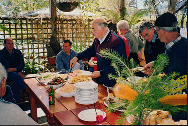
 Wooragee Landcare Group
Photograph, 5 September 2004
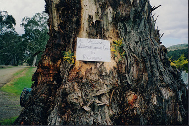
Wooragee Landcare was formed in 1989 to promote sustainable conservation and land-use practices in the North-East region of Victoria. The organisation's work has included public awareness and education campaigns to control invasive, introduced species and protect native wildlife, such as campaigns to replant native plant species to improve soil integrity and restore habitat for flora and fauna. The organisation has drawn on the work of a variety of Government and academic experts to ensure best practice approaches are utilised. This photograph was taken at Riverview Farm, Victoria on Sunday the 5th of September as part of a day trip by the Wooragee Landcare Group. The event was about looking at land use on small farms and as a social get-together for the Group. Wooragee was also researching how small landholders could run some enterprises around the time of the trip. This photograph is a great example of the type of events that Wooragee Landcare Group has organized, while educating the public about the importance of land use management.Landscape colour photograph printed on gloss paper. Reverse: WAN NA E0NA2N2. NNN+ 4 4240/ [PRINTED] (No. 24) / 377wooragee, wooragee landcare group, wooragee landcare's collection, land use, social, riverview farm, animals, pests, indigo shire, tatong, samaria, north-east victoria -
 Wooragee Landcare Group
Photograph, circa April 2003
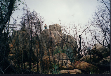
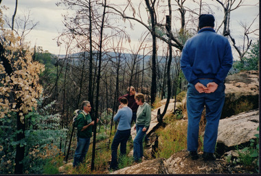
This photograph was taken in the Mount Pilot Chiltern National Park. This park is located near Chiltern in Victoria. It's most notable landmarks include Mt Pilot and Woolshed Falls. It also has many mines from the Gold Rush in the late 1800s. It is home to much flora and fauna, including the tiger quoll. The tiger quoll, also known as the spotted-tail quoll, is a marsupial that gives in the Mount Pilot Chiltern National Park. It is also main land Australia's largest carnivorous marsupial. It can weigh up too four kilograms and looks similar to either a possum or a spotted cat. It has red and brown fur with distinct spots. The tiger quoll is found along the Great Dividing Range, which includes Victoria, New South Wales and also near the border of Queensland. It lives in forests, rainforests and coastal heathlands and woodlands. In 2004 a team of volunteers from the Wooragee Landcare group as well as some of the Department of Sustainability and Environment staff set out to find the tiger quoll following the 2003 bushfires. Since the bushfires, concern had arisen for it because it hadn't been seen since the bushfires. They attempted to find traces of the quoll through finding and identifying their droppings as well as DNA testing. This photograph was taken during this search. This photograph represents the work that goes into protecting a important species like the tiger quoll. The tiger quoll is a significant species because it is main land Australia's largest carnivorous marsupial. As a result of this, there has been much work done to preserve and protect it. This photograph was taken when the Wooragee Landcare group went to ensure the survival of this species, highlighting how the tiger quoll is being protected. This photograph also demonstrates the impacts of the 2003 bushfires in the Mount Pilot Chiltern National Park. This is seen through the burnt trees featured in the picture. Landscape coloured photograph printed on gloss paperReverse: WAN NA 0ANA0N0 NNN 0 1636 / [PRINTED] (No.7) / 921quoll, mount pilot chiltern national park, national park, 2003 bushfires, search, endangered, beechworth, wooragee landcare group, wooragee landcare, wooragee, possum, australia, victoria, department of sustainability and environment, photograph, 2004, spotted-tailed quoll, great dividing range, spots, fur, forests, rainforests, woodlands, coastal heathlands, spotted quoll, spotted quoll habitat -
 Wooragee Landcare Group
Photograph, 3rd April 2004
This photograph depicts fox behaviour specialist Camille Veselsky demonstrating the use of a fox bait trap at an event conducted as part of an awareness campaign highlighting damage done to farm and domestic animals and native wildlife in April 2004. Camille Veselsky is a specialist in fox behaviour who worked for the Hume Rural lands Protection Board on pest animal control for 27 years. This date is suggested by the photograph's position in the 2004-2005 Wooragee Landcare Group Coordinator's Report folder. A note accompanying the item suggests an alternative date of February 2004, however. This event raised awareness about the impacts of foxes in rural areas and provided practical training in techniques to control their populations. Flyers contained in the parent folder suggest that baiting may have been agreed as a method of fox control as the event depicted was followed by a two week baiting campaign a fortnight later. Pictured in the photograph, left to right: unknown, Quentin Mansfield; four unknown people; Mary Prowse; two unknown people; Helmut Wiemann; unknown person. In the folder, the photograph is accompanied by a printed label stating: 'Train foxes to take free feeds before using the 1080. Small traces of fish oil can help attract foxes to the bait station.' Regional areas like Wooragee are susceptible to fox attacks due to the availability of food such as rubbish, scraps, native wildlife and livestock. Foxes can have a huge impact on native wildlife and domestic life as they are known to chew through irrigation systems, dig-up and defecate in gardens, raid rubbish bins and harass other domestic animals. Ground-dwelling native species are particularly susceptible to predation by foxes, which when combined with loss of habitat can endanger these species. Affected species include Speckled Warblers, Plovers, Diamond Firetails, Spotted Quail-Thrushes, Turquoise Parrots, Dunnarts, Bandicoots, Phascogales, skinks, geckos and legless lizards. This photograph is significant as an example of awareness raising and threat control programs undertaken by Wooragee Landcare Group in the 2000s in Indigo Shire.Landscape coloured photograph printed on gloss paper. Reverse: 25 / 2 [HANDWRITTEN] WAN NA 0ANA2N0 NNN+ 1 8743 / [PRINTED] (No.12) / 258wooragee, wooragee landcare group, indigo shire, north-east victoria, fox, foxes, pest control, vermin, conservation, baiting, trapping, farming, wildlife, speckled warblers, plovers, diamond firetails, spotted quail-thrush, turquoise parrot, dunnarts, bandicoots, phascogales, skinks, geckos, legless lizards, camille veselsky -
 Wooragee Landcare Group
Photograph, 28th April 2004
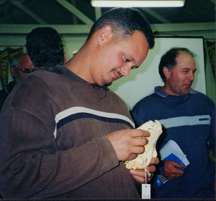
This photograph was taken at Wooragee Hall on Wednesday the 28th of April 2004 called 'Queries about Quolls' and shows a Quoll Presentation by Andrew Murray at Mt Pilot, Chiltern Mt Pilot National Park. The photograph shows (L - R) Jerry Alexander, Unknown, Unknown, Mary Prowse, Tony Prowse. The event was hosted by the Wooragee Landcare Group and was led by Andrew Murray (of Parks Victoria), President of the South-East Forest Spotted-tailed Quoll Working Group and one of Victoria's leading authorities in quolls. As the name of the event would suggest, this session provided attendees with insight and general information on quolls, including the characteristics of quolls, the habitat of quolls and the techniques that can be used when searching for quolls which was part of a wider project aimed at protecting the endangered species of the tiger quoll, also known as the spotted-tailed quoll, an animal that once inhabited Mount Pilot-Chiltern National Park. This particular photo shows a group of attendees looking at a typical quoll nesting site in a rock crevice. According to an article included in the Wooragee Landcare group coordinators annual report 2004 and 2005 album (record 00001), Andrew Murray had been tasked to train a team of Department of Sustainability and Environment staff and volunteers from the local area (Beechworth and Wooragee) in the detection skills needed to establish whether the tiger quoll still inhabited the Mount Pilot-Chiltern National Park and had survived after a bush fire in 2003 had burned through the area where they would normally have been found. The Tiger Quoll is the largest of the quoll species. Largely resembling a cross between a possum and a cat, the quoll is distinctive due to the white spots that are often found all over its brown fur.This photograph is significant as it provides evidence of a project undertaken by the Wooragee Landcare Group to educate themselves and members of the public on the tiger quoll in the early 2000s in an attempt to better understand and protect the species. The Wooragee Landcare Group has been instrumental in the co-ordination of programs relating to biodiversity protection in the local area, providing great assistance to landholders.Landscape coloured photograph printed on gloss paperReverse: WAN NA 0ANA2N0 AN2 0 1636 / [PRINTED] (No.4) / 918wooragee, wooragee hall, wooragee landcare, wooragee landcare group, quoll, spotted-tailed quoll, tiger quoll, queries about quolls, south east forest spotted-tailed quoll working group, andrew murray quolls, mount pilot chiltern national park, quoll species, endangered quoll, andrew murray, beechworth, landcare group, mount pilot -
 Wooragee Landcare Group
Photograph, 28th April 2004
Wooragee Landcare was formed in 1989 to promote sustainable conservation and land-use practices in the North-East region of Victoria. The organisation's work has included public awareness and education campaigns to control invasive, introduced species and protect native wildlife, such as campaigns to bait or trap foxes and to identify and monitor quoll populations in the region. The organisation has drawn on the work of a variety of Government and academic experts to inform best practice approaches are utilised. In 2004 Andrew Murray, a leading quoll expert from Parks Victoria, conducted training for Wooragee Landcare members and the local community in how to identify potential quoll habitat and populations (through identifying scat and other methods). Spotted-tail or Tiger quolls were known to have lived in the Mt Pilot and Stanley Plateau region previously but habitat encroachment, competitor species such as foxes and natural disasters had reduced sightings in recent years. The Spotted-Tail quoll (formerly known as the Tiger Quoll) is the largest of four species of native marsupial carnivore on mainland Australia, and the second-largest carnivore (after the dingo). The species' scientific name, Dasyurus maculatus, references its' 'hairy tail'. Adults are approximately 125cm long, including their long tail, and weigh around 5 kilograms. The Spotted-tail quoll is currently considered to be a threatened species, but other species are currently listed as endangered. This photograph is significant as an example of wildlife protection awareness programs undertaken by Wooragee Landcare Group in the 2000s in Indigo Shire.Landscape coloured photograph printed on gloss paper.Reverse: WAN NA 0ANA2N0 NNN+ 2 8743 / [PRINTED] (No.22) / 268wooragee, wooragee landcare, kiewa landcare, indigo shire, north-east victoria, farming, conservation, wildlife, quoll, quolls, marsupials, predators, simon feillafe, andy murray, south-east forests, spotted tail quoll, mt pilot, stanley plateau, andrew murray -
 Wooragee Landcare Group
Photograph, 3rd April 2004
This photograph depicts people attending the 'Spotlight on Fox' event watching a demonstration. The event was conducted as part of an awareness campaign highlighting damage done to farm and domestic animals and native wildlife in April 2004. This date is suggested by the photograph's position in the 2004-2005 Wooragee Landcare Group Coordinator's Report folder. A note accompanying the item suggests an alternative date of February 2004, however. This event raised awareness about the impacts of foxes in rural areas and provided practical training in techniques to control their populations. Flyers contained in the parent folder suggest that baiting may have been agreed as a method of fox control as the event depicted was followed by a two week baiting campaign a fortnight later. Pictured in this photograph, left to right: unknown; Sue Berwick ; Jerry Alexander; rest unidentified. A note accompanying the items suggests the photograph may have been taken by Karen Bowley or Maree Missen. Regional areas like Wooragee are susceptible to fox attacks due to the availability of food such as rubbish, scraps, native wildlife and livestock. Foxes can have a huge impact on native wildlife and domestic life as they are known to chew through irrigation systems, dig-up and defecate in gardens, raid rubbish bins and harass other domestic animals. Ground-dwelling native species are particularly susceptible to predation by foxes, which when combined with loss of habitat can endanger these species. Affected species include Speckled Warblers, Plovers, Diamond Firetails, Spotted Quail-Thrushes, Turquoise Parrots, Dunnarts, Bandicoots, Phascogales, skinks, geckos and legless lizards. This photograph is significant as an example of awareness raising and threat control programs undertaken by Wooragee Landcare Group in the 2000s in Indigo Shire.Landscape coloured photograph printed on gloss paperReverse: WAN NA 0ANA2N0 NNN 0 8743 / [PRINTED] (No. 13) / 259wooragee, wooragee landcare, indigo shire, north-east victoria, foxes, fox, pest control, vermin, conservation, baiting, trapping, events, 2004, wildlife, speckled warbler, plovers, diamond firetails, spotted quail-thrush, turquoise parrots, dunnarts, bandicoots, phascogales, skinks, geckos, legless lizards, farming, chickens, ducks, guinea-pigs -
 Wooragee Landcare Group
Photograph, 20th June 2004
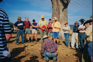
Photo shows (L-R) Bob Dunnett; Tony Prowse; Mary Prowse; Ray Henderson; unknown; Lesley Finedon; unknown; unknown assessing successful stream side rehabilitation at Bev DeJong and Bob Dunnett's place during a paddock demonstration and tree planting field day, called 'Really Successful Tree Planting!' run by Wooragee Landcare on Sunday 20th June 2004. Maintaining and reforesting native trees, shrubs and grasses are really important for a variety of reasons, including creating native habitat and food for birds and other animals, shade, biodiversity, visual appeal, cooling, shade for urban areas, sequestering carbon and conservation among other considerations. The planting must be consistent with the particular needs of the environment, such as trees or shrubs which would naturally occur and are native to the area. Tree planting demonstrations such as this one run by the Landcare Group ensures that the projects are being managed consistently with an overarching commitment to land protection and management and the best methods for best outcomes are employed. This photograph is significant as it provides evidence of a project undertaken by the Wooragee Landcare Group to educate themselves and members of the public on successful techniques needed to plant and maintain trees for replanting in the Wooragee area. The Wooragee Landcare Group has been instrumental in the co-ordination of programs relating to biodiversity protection in the local area, providing great assistance to landholders.Landscape coloured photograph printed on gloss paperReverse: WAN NA 0ANA2N0 NNN+ 1 1636 / [PRINTED] (No.19) / 933wooragee landcare, wooragee landcare group, beechworth, landcare group, wooragee, tree planting, successful tree planting, demonstration, paddock demonstration, tree planting field day, really successful tree planting, land protection and management, land management, native trees, conservation -
 Wooragee Landcare Group
Photograph, c2004
This photograph was taken during one of a series of workshops that were hosted by the Wooragee Landcare Group in the year 2004. In line with the main goals and missions of the Wooragee Landcare Group, these workshops aimed to promote biodiversity and land protection in the local area. Many of these workshops focused on either the protection of the endangered tiger quoll (spotted-tailed quoll) or the handling of fox infestations. Though the specific date of this photograph is unknown, it can be confirmed that it was taken outside of Wooragee Hall. Featured in the photograph, from left to right is: an unknown person, Jerry Alexander, Tony Prowse and Mary Prowse. The presence of wildlife ecologist Jerry Alexander suggests that this workshop focused on the tiger quoll, with possible exploration of its potential habitats (suggestive due to the outdoor location). The Tiger Quoll is the largest of the quoll species. Largely resembling a cross between a possum and a cat, the quoll is distinctive due to the white spots that are often found all over its brown fur.This photograph is significant as it provides evidence of a project undertaken by the Wooragee Landcare Group to educate members of the public on the tiger quoll in the early 2000s in an attempt to better understand and protect the species. The Wooragee Landcare Group has been instrumental in the co-ordination of programs relating to biodiversity protection in the local area, providing great assistance to landholders.Landscape coloured photograph printed on gloss paper. Reverse: WAN NAO1EONAON2. NNN- 1 1981 / wooragee, wooragee hall, wooragee landcare, wooragee landcare group, quoll, spotted-tailed quoll, tiger quoll, jerry alexander, jerry alexander ecologist, jerry alexander wildlife, tiger quoll habitat -
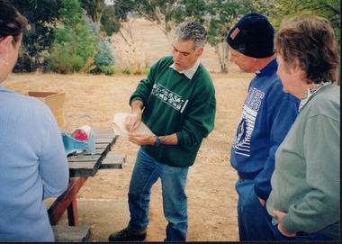
 Wooragee Landcare Group
Photograph, 27 August 2004
This photograph was taken on the 27th of August 2004 as a part of the Direct Seeding Expo held at Wooragee Hall. The event aimed to educate attendees about the methods and benefits of direct seeding. Direct seeding is a technique used to sow seeds into the ground to achieve germination and establishment so that crops can grow. The photo shows attendees of the event gathered around James Scholfield (who is not pictured) as he discusses and demonstrates methods of direct seeding like mouldboard ploughing and hand broadcasting a mixture of seed and river sand. James Scholfield has been a farmer and Greening Australia Project Officer for over 8 years and has significant experience with direct seeding, which is why he was chosen to attend this event in Wooragee. Two people have been identified in this photograph. Marcus O'Connor (left) is the property owner the workshop was held on and Robin Warner (third from the left) was the then president of Wooragee Landcare Group.This photograph exemplifies the educational events Wooragee Landcare Group hosted in order to inform the public about new methods or techniques about seed sowing that they did not already know. The photo holds significance to the people of Wooragee and the surrounding localities due to the informative nature of these events which may have aided them when working in their own farms or properties.Landscape coloured photograph printed on gloss paperReverse: WAN NA E0NA2N2 NNN+ 3 4240 / [PRINTED] (No.12) / 365wooragee, wooragee hall, wooragee landcare, wooragee landcare group, direct seeding, germination, seeds, james scholfield, crops, ploughing, mouldboard ploughing, hand broadcasting, greening australia project -
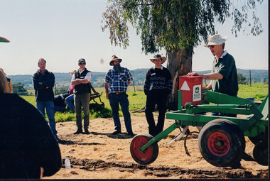 Wooragee Landcare Group
Photograph, 27 August 2004
This photograph was taken on Friday the 27th of August 2004 as part of an event called 'Direct Seeding Expo'. This event was one of many held by the Wooragee Landcare Group in the early 2000s which aimed to educate the local community on certain agricultural and biodiversity conservative techniques. This particular event took place at the property of Lisa and Marcus O'Connor in Wooragee. This photograph shows farmer and Greening Australia Project Officer James Scholfield giving a demonstration on the Hamilton Tree Seeder (a soil ripper). This machine is used to loosen tough, compact soil in order to prepare it for the planting of seedlings. This photograph is significant as it provides evidence of a project undertaken by the Wooragee Landcare Group in the early 2000s to educate members of the public on alternative and potentially more efficient methods of planting seedlings. The Wooragee Landcare Group has been instrumental in the co-ordination of programs relating to biodiversity protection in the local area, providing great assistance to landholders.Landscape coloured photograph printed on gloss paperReverse: WAN NA EONA2N2. NNN 0 4240 / lisa and marcus o'connor, direct seeding expo, direct seeding, seedlings, seeding methods, wooragee landcare group, wooragee, james scholfield, greening australia project, hamilton tree seeder, soil ripper, ripper -
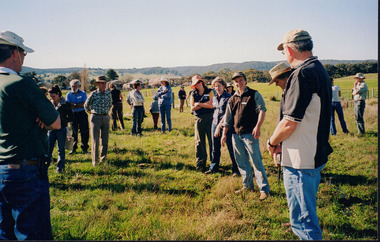 Wooragee Landcare Group
Photograph, 27 August 2004
This photograph was taken on Friday the 27th of August 2004 as part of an event called 'Direct Seeding Expo'. This event was one of many held by the Wooragee Landcare Group in the early 2000s which aimed to educate the local community on certain agricultural and biodiversity conservative techniques. This particular photograph shows attendees at the property of Neil and Anne Nankervis, inspecting sites where direct seeding had been used ten months earlier. Three different direct seeding techniques were demonstrated during the day by several experts in the field. Direct seeding involves the sowing of seeds directly into the soil to achieve germination and establishment. It is an alternative to planting seedlings in a contained nursery plot. This direct method is intended to mimic a more natural process of growth, revegetating larger areas in a more efficient manner.This photograph is significant as it provides evidence of a project undertaken by the Wooragee Landcare Group in the early 2000s to educate members of the public on alternative and potentially more efficient methods of planting seedlings. The Wooragee Landcare Group has been instrumental in the co-ordination of programs relating to biodiversity protection in the local area, providing great assistance to landholders.Landscape coloured photograph printed on gloss paperReverse: WAN NA EONA2N2. ANN+ 1 4240 / neil and anne nankervis, wooragee, wooragee landcare group, wooragee landcare, direct seeding expo, direct seeding, seeding, seedlings, direct seeding sites, alternative seeding, alternative seeding method -
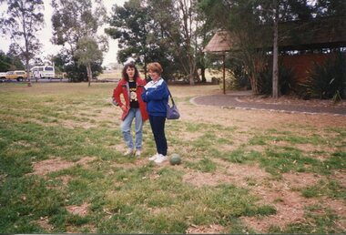 Broadmeadows Historical Society & Museum
Photograph, Two Adults in the Park, 1990
This photograph, taken during Jacana Primary School’s 1990 Christmas picnic—believed to have been held at Greenvale Reservoir, a well-loved recreational spot in Melbourne’s northern suburbs—captures a relaxed and festive moment. It features two adults, likely members of the teaching staff, posing together in a cheerful outdoor setting, reflecting the school’s tradition of fostering community spirit and celebrating the end of the school year with informal gatherings.This photograph, taken during Jacana Primary School’s 1990 Christmas picnic—likely held at Greenvale Reservoir, a popular recreational site in Melbourne’s northern suburbs—captures a casual portrait of two adults, presumed to be members of the teaching staff, enjoying the festive outdoor gathering. The image offers a glimpse into the school’s social and professional culture at the time, highlighting the informal, community-oriented atmosphere that characterised end-of-year celebrations. Established in 1959, Jacana Primary School was a cornerstone of the local community until its closure in the early 2000s, known for its emphasis on both academic achievement and social cohesion. Events like the annual Christmas picnic played a key role in strengthening relationships among students, staff, and families, fostering a sense of belonging and shared celebration. The presence of staff members in this relaxed setting underscores their role not only as educators but also as active participants in the school’s broader community life. Their engagement in such events reflects the school’s commitment to nurturing strong, supportive connections between teachers and students, reinforcing the values of inclusivity and community spirit.Colour Photograph on glossy paper in landscape formatPH18289 (crossed out) PH-4209 (crossed out) PH-4868/this paper/manufactured/by Kodakjacana primary school, christmas party, 1990, jacana -
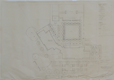 Federation University Historical Collection
Plan - Plans, Ballarat School of Mines Brewery Building Plans, 1995, 1995
The Ballarat School of Mines Brewery Building is now a part of the Ballarat Technology Park.Site plan and landscape plan for Stage 3 works for the Ballarat School of Mines Brewery Building. .1) Site plan by Philip Cox Sanderson & Partners, Melbourne .2) Landscape plan by John Patrick Pty Ltd, Landscape consultants, Kew, Victoriaballarat school of mines, brewery building, ballarat technology park, john patrick, philip cox sanderson, landscaping, archtectural plans -
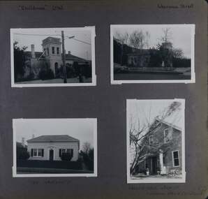 Glen Eira Historical Society
Album - Album page, Ercildoune (576), Inkerman Street, Circa 1972
This photograph is part of the Caulfield Historical Album 1972. This album was created in approximately 1972 as part of a project by the Caulfield Historical Society to assist in identifying buildings worthy of preservation. The album is related to a Survey the Caulfield Historical Society developed in collaboration with the National Trust of Australia (Victoria) and Caulfield City Council to identify historic buildings within the City of Caulfield that warranted the protection of a National Trust Classification. Principal photographer thought to be Trevor Hart, member of Caulfield Historical Society. Most photographs were taken between 1966-1972 with a small number of photographs being older and from unknown sources. All photographs are black and white except where stated, with 386 photographs over 198 pages. Vol 1 Caulfield's Building Heritage by Dr Geulah Solomon states that Ercildoune was the home of Sir Samuel Wilson and later, Arthur Knox. Knox is likely the person who subdivided the land, creating Ercildoune Street.Page 100 of Photograph Album with two photographs (landscape) of Ercildoune and two photographs (one landscape and one portrait) of two other houses on Inkerman Street.Handwritten: "Ercildoune" (576) [top left] / Inkerman Street [top right] / 138 INKERMAN ST [under bottom left photo] / LABASSA GROVE CORNER OF INKERMAN OPPOSITE ERCILDOUNE [under bottom right photo] / 100 [bottom right]trevor hart, east st kilda, ercildoune, mansions, towers, gardens, bloomsbury, inkerman road, labassa grove, attic houses, porches, inkerman street, caulfield north, st kilda east, sir samuel wilson, arthur knox, ercildoune street, house names -
 Nillumbik Shire Council
Video (HD): Ash KEATING, North Park Proposition (from the 'Urban Boundary Proposition' series)
Video of artist painting the facade of a concrete warehouse into a ‘Trompe-l’oeil’ landscape painting using fire extinguishers as paint brushes. The warehouse slowly disappears into the landscape. -
 University of Melbourne, Burnley Campus Archives
Photograph - Colour print, Burnley Campus Archives, The Dairy Shed in 1990, 1990
Appears to have been used in an exhibitionColour photograph pasted on polystyrene board. Renovated and repurposed DairyCaption, "The dairy shed in 1990, by now reclad. In the 1980's it was used for storage of landscape and arboriculture equipment."dairy shed, storage, equipment, dairy, renovated -
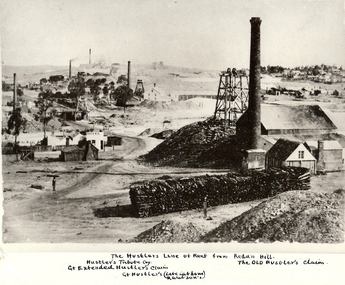 Bendigo Historical Society Inc.
Photograph - HUSTLER'S LINE OF REEF
BHS CollectionBlack and white photograph of mining landscape with poppet head, chimney and mining sheds (plus timber in stack) in foreground. Other mines in bare landscape on LHS background and housing on RHS background. Inscriptions: on front - 'The Hustler's Line of Reef from Redan Hill Hustler's Tribute Coy', 'Gt. Extended Hustler;s Claim', 'The Old Hustler's Claim, Gt. Hustlers (Late Latham & Watson's). On back - 'A Richardson, 29 Harrison Street, Bendigo'.mine, gold, hustlers reef mine, bendigo, mines and mining, mine, mines, mining, landscape, mining landscape, redan hill, poppet head, old hustlers, mining cottages -
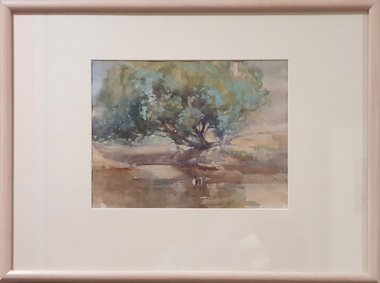 Federation University Art Collection
Painting - Watercolour, McGeorge, Norman, Untitled, c mid 1940s
Norman MacGEORGE (08 July 1872– 2 September 1952) Born Adelaide, South Australia Norman Macgeorge taught drawing at Wesley College, Melbourne from 1902-06. He also taught at Melbourne Teachers' College and at Melbourne Church of England Grammar School. This item is part of the Federation University Art Collection. The Art Collection features over 2000 works and was listed as a 'Ballarat Treasure' in 2007.Framed landscape depicting the confluence of the Darebin Creek and the Yarra River. Purchased by the Ballarat Teachers' College in 1964. This work was exhibited in "Norman MacGeorge: Man of Art" at the Ian Potter Museum of Art, The University of Melbourne, 22 September to 25 November 2001.art, artwork, norman mcgeorge, mcgeorge, watercolour, available, landscape, darebin creek, yarra river, ballarat teachers' college art collection -
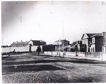 The Beechworth Burke Museum
Photograph, 1865
A photograph of Ford street, Beechworth. It features the old Gaol with the Telegraphs Office, Gold Wardens and Courthouse Office.A photograph that features several important buildings in the early history of Beechworth law enforcement, including the Courthouse and Gaol. Black and white landscape photograph on matte photographic paper.old beechworth gaol, telegraph office, beechworth courthosue -
 The Beechworth Burke Museum
Photograph, George Peach, c. 1930
Black and White photograph taken of the Robert O'Hara Burke Memorial Museum. The museum is named in honor of explorer and former Beechworth Superintendent Robert O'Hara Burke following his death in 1861.This item is significant because it shows the historic Burke Museum in a historic context, which can be used to document the changes in the building and the surroundings which have occurred over time.Copy of a black and white landscape photograph on photographic paper.burke museum, robert o'hara burke, robert o'hara burke museum -
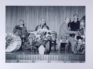 Mission to Seafarers Victoria
Photograph - Photograph, copy, circa 1956
Example of entertainment at the Mission in the 1950's. Lay Reader David Conolly featured in photo.small rectangular black and white photograph in landscape format.Inscription on back of photo: "Circa 1956-7 - the regular dance band for the dance at the Flinders Street Mission. Standing by the piano the staff compere, Lay Reader David Conolly."david conolly, lay reader, orchestra, music, dance, lhlg, concerts, band, saxophone, piano, drums, flowers, curtains, events -
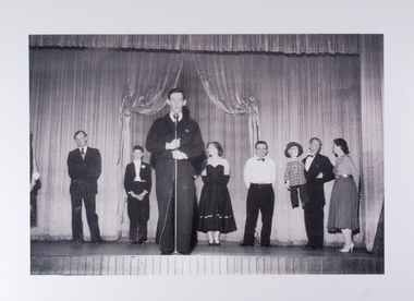 Mission to Seafarers Victoria
Photograph - Photograph, copy, 1956-1958
Lay Reader David Conolly thanking a concert party at the conclusion of their performance.Lay Reader David Conolly hosts a typical evening's entertainment at the Mission.small rectangular black and white photograph in landscape format.Inscription on back of photo: "Thanking a concert party at the conclusion of their performance at the Flinders Street Mission to Seamen, Circa 1956. At the microphone, stipendiary Lay Reader David Conolly."david conolly, lay reader, concerts, events, entertainment, artists, music, microphone, stage, curtains -
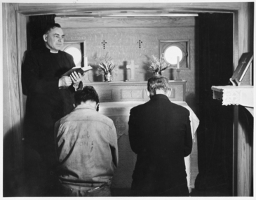 Mission to Seafarers Victoria
Photograph - Mounted photograph, Black and white, Reverend Fred Laight conducting a service in the floating church the "John Ashley"
large rectangular b/w photograph in landscape format. Inscription typed on paper and stuck to back of photo: "The Rev. Fred Laight conducts a service on board the mission launch JOHN ASHLEY"john ashley, floating church, reverend laight, fred laight, reverend john ashley (1801-1886), mission to seamen, river thames, england -
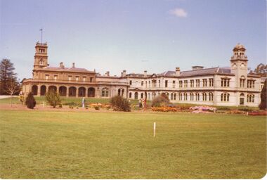 Bendigo Historical Society Inc.
Photograph - COLOUR PHOTOGRAPH OF BUILDINGS AND LANDSCAPE
Colour photograph of Buildings and landscape. Possibly Werribee Mansion.photograph, building