Showing 22608 items
matching matthew-creek
-
 Mt Dandenong & District Historical Society Inc.
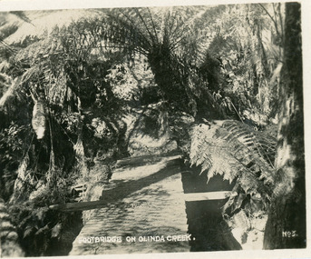
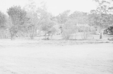
Photograph, Footbridge On Olinda Creek, late 1930s
Number 3 in commercial series.Small photograph, number 3 in Olinda series, showing footbridge over Olinda Creek surrounded by tree ferns. Late 1930s.olinda creek, footbridge, bridge, olinda, creek, tree ferns, ferns, bush -
 Coal Creek Community Park & Museum
Farmed Mine Map, Map Of Underground Workings of Coal Creek Mine, 1896
8515.1 - Map of underground tunnels at a coal creek mine. Frame has a paper label rotted and faded almost beyond legibility. -
 Tarnagulla History Archive
Unpublished manuscript: Sandy Creek 1852, Tarnagulla 1861 - History of the Goldfields, Sandy Creek 1852, Tarnagulla 1861 - History of the Goldfields, 1999
Donald Clark Collection. An unpublished research manuscript with title 'Sandy Creek 1852, Tarnagulla 1861 - History of the Goldfields' by Donald Clark. Plastic spiral bound.tarnagulla, local history, gold, goldfields -
Ballarat Heritage Services
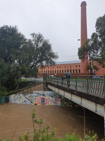
Video, Clare Gervasoni, Yarrowee Creek and Sunnyside Mill after heavy rain, 2022, 13/10/2022
Video of the Yarrowee Creek flowing down the channel at Sunnyside Corner (Mill St) after a day of very heavy and consistent rain.yarrowee creek, mill st ballarat, yarrowee channel, sunnyside corder, bridge, sunnyside mill -
 Ballarat Heritage Services
Photograph - Bridge, Clare Gervasoni, Yarrowee Creek and Sunnyside Mill after heavy rain, 2022, 13/10/2022
Photographs of the Yarrowee Creek flowing down the channel at Sunnyside Corner (Mill St) after a day of very heavy and consistent rain.yarrowee creek, mill st ballarat, yarrowee channel, sunnyside corder, bridge, sunnyside mill -
Ballarat Heritage Services
Video, Clare Gervasoni, Yarrowee Creek after heavy rain, 2022, 13/10/2022
An mp4 of the Yarrowee Creek flowing down the channel at Sunnyside Corner (Mill St) after a day of very heavy and consistent rain.yarrowee creek, mill st ballarat, yarrowee channel, sunnyside corder -
 Lorne Historical Society
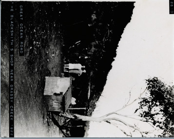
Photograph, Blacksmiths shop near Grassy Creek 1Great Ocean Road 1922
Photograph of C.R. B blacksmith's shop near Grassy Creek 1922. showing workers in lean to and other figures off road. g.o.r; grassy-creek; blacksmiths; c.r.b -
 Lorne Historical Society
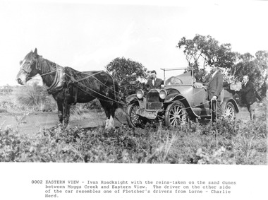
Photograph, Horse and Car near Moggs Creek
Photograph taken between Moggs Creek and Eastern View, of Ivan Roadnight (holding the horse reins) and Charlie Herd (driving the car) ivan roadnight, charlie herd, moggs creek, eastern view, horse and car -
Lakes Entrance Regional Historical Society (operating as Lakes Entrance History Centre & Museum)
Book, White, Kelvin, Angus McMillan Memorial Cairn, Dargo Road, Iguana Creek, 2002
Research, interpretation and management recommendations for the Angus McMillan memorial cairn, Dargo Road, Iguana Creek, Gippsland, Victoria, by Forestec Studentmemorials, explorers -
 Eltham District Historical Society Inc
Slide - Photograph, Diamond Creek Trail, Diamond Creek, c.Nov. 2001
Part of a slide show presentation "A Trip Down the Diamond Creek" by Russell Yeoman to the Eltham District Historical Society meeting of 14 Nov. 200135mm colour positive transparency Mount - Black and Whitediamond creek, diamond creek trail, marion yeoman -
 Ringwood and District Historical Society
Photograph, View along the bank of the Mullum Creek at the foot of New Street 1981
Written on back of photograph, "16/7/81. View along the bank of the Mullum Creek at the foot of New Street." -
 Ringwood and District Historical Society
Photograph, Mullum Mullum Creek- 29-10-89
Black and white photograph"Written on back of photograph" Mullum Mullum Creek Looking East (upstream) North Bank near Harrison St -
 Greensborough Historical Society
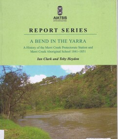
Book, Ian D. Clark et al, A Bend in the Yarra: a history of the Merri Creek protectorate Station and Merri Creek Aboriginal School 1841-1851, by Ian D. Clark and Toby Heydon, 2004_
A history of Aboriginal cultural institutions in colonial Victoria, in this book the interaction between Wurundjeri people and government officials and settlers at the confluence of the Merri Creek and Yarra River.Paperback book, 90 p. black & white illusmerri creek, aborigines victoria -
 Whitehorse Historical Society Inc.
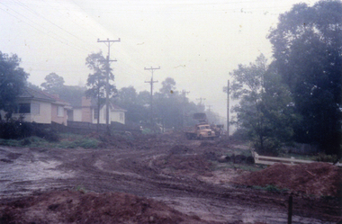
Photograph, Creek Road - road making, 1/06/1961 12:00:00 AM
Colour photo taken of a 33mm slide of the Creek road being constructed in June 1961 (Note first sign of brick veneer in street.)creek road mitcham, tresider, dot, road construction and maintenance -
 Southern Sherbrooke Historical Society Inc.
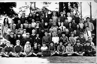
Photograph, Menzies Creek State School, 22nd November 1972
Photo of students and two teachers at Menzies Creek State School, 22nd November 1972. Head Teacher on right is Donald H. Jewell. -
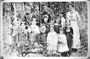
 Southern Sherbrooke Historical Society Inc.
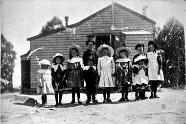
Photograph, Menzies Creek State School
A photograph of eight girls and two boys lined up in front of the Menzies Creek State School. They appear to be dressed up in their best clothes. -
 Ringwood and District Historical Society
Photograph, Mullum Creek. Taken from footbridge at end of Adelaide St, Ringwood. Aug. 1973
See also 2983Backing sheet on two copies reads, "Mullum Creek, Aug. 1963. Taken from footbridge at end of Adelaide St." Other copy reads, "Same area of flooded Mullum Creek as photo 403. A week later 1963".(Photo 403 is RE34 in Record 2983) -
Ringwood and District Historical Society
Document, Electoral District of Evelyn - Anderson's Creek Division. List of Ratepaying Electors - 1890 -91
Typed document Legislative Assembly - Electoral District of Evelyn - Anderson's Creek Division. Alphabetical list of Ratepaying Electors including residence and occupation. -
 Ringwood and District Historical Society
Photograph, Old baths site looking north west over creek to Ringwood Street, Late 1980
Written on back of photograph, "Late '80. Old baths site looking north west over creek to Ringwood Street." -
 Ringwood and District Historical Society
Photograph, Looking east along Dandenong Creek from very end of Heatherdale Road, Vermont South
Written on back of photograph, "Jan. 79. Looking east along Dandenong Creek from very end of Heatherdale Road." -
 Ringwood and District Historical Society
Photograph, Playing space corner Ringwood St. and Reynolds Ave. Ringwood, alongside Mullum Creek. 1973
Written on backing sheet, "Playing space corner Ringwood St. and Reynolds Ave. alongside Mullum Creek." 7/73 -
Ringwood and District Historical Society
Report, Radden, W.W.L, History of Anderson's Creek 1856-1865 by W.W.L. Radden January 1965, Jan-65
History of Anderson's Creek 1856-1865 - 7 foolscap pages and map prepared by W.W.L. Radden January 1965 +Additional Keywords: Radden, W.W.L. -
 Upper Yarra Museum
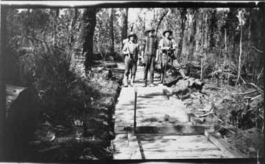
Negative Photographic Reproduction, Laying the tram track to Clover Dell Mill with E. Smith , W Towers …. Hoddles Creek
Laying the tram track to Clover Dell Mill with E. Smith , W Towers & ? Hoddles Creek Negative Black white Scanned at 600 dpi.laying tram track clover dell mill e smith w towers hoddle creek -
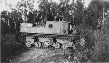 Upper Yarra Museum
Negative Photographic Reproduction, George (Mick) Worlley’s Grant tank used for clearing scrub 1952 Hoddles Creek
George Worlley bought a Grant Tank from Bandiana for clearing scrub and falling trees for the mill in 1952George (Mick) Worlley’s Grant tank used for clearing scrub 1952 Hoddles Creek Black and White negative scanned at 600 dpi Check no -
 Eltham District Historical Society Inc
Photograph, Upper Diamond Creek, Silvan Gully area, 1911
Two colour photograph copies of originals of Main Road through Silvan Gully area upper Diamond Creek prior to construction of the railway in 1911upper diamond creek, wattle glen, hurstbridge, silvan gully, hurstbridge road, kinglake road, heielberg kinglake road -
Eltham District Historical Society Inc
Photograph, Diamond Creek floods, 1953
Three photographs of floods Diamond Creek, Eltham, 21/10/1953, showing Brougham Street and Main Road near Eltham Primary Schooldiamond creek, floods, brougham street, main road -
Whitehorse Historical Society Inc.
Document, Land along Mullum Mullum Creek, 1994
Nunawading City Council minute on land along Mullum Mullum Creek west of Schwerkolt Cottage. 40/11/006 BPS/BN/DWTNunawading City Council minute on land along Mullum Mullum Creek west of Schwerkolt Cottage. 40/11/006 BPS/BN/DWTNunawading City Council minute on land along Mullum Mullum Creek west of Schwerkolt Cottage. 40/11/006 BPS/BN/DWTlocal government, city of nunawading, parks and reserves, schwerkolt cottage, yarran dheran, mullum mullum creek -
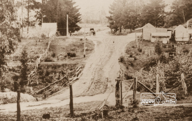
 Whitehorse Historical Society Inc.
Photograph, Creek Road Mitcham - June 1961, 1/06/1961 12:00:00 AM
Colour photo taken from a 35mm slide of the houses in Creek road Mitcham in June 1961 at the time when the roads were being madecreek road, mitcham, road construction and maintenance, tresider, dot -
 Southern Sherbrooke Historical Society Inc.
Photograph, Menzies Creek State School photo
A photograph of students from the Menzies Creek State School. Fiftenn children and a female teacher are standing in front of heavy bushland. Believed to be early 1900s. -
Lakes Entrance Regional Historical Society (operating as Lakes Entrance History Centre & Museum)
Book, TRAM Engineering and Services Pty. Ltd, Inspection Report - Stony Creek Bridge - Bairnsdale-Orbost Rail Trail, 2001
A report on the condition of the Stony Creek Railway bridge, Gippsland, Victoria, as well as the work required to ensure the stability of the bridge and make it suitable for use as a footbridge.transport, bridges, engineering